Blue Ridge Parkway: Sam Knob - Flat Laurel Creek - Chestnut Bald Loop Trail, Brevard, North Carolina5/13/2014 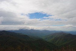 The Blue Ridge Parkway has some of the best hiking destinations in North Carolina, and this is only the second time I've been there (after Mount Pisgah three years ago). The Black Balsam/Sam Knob area is a small triangle between two wilderness areas and the Parkway. The views are grand from the whole hike, and many mountain tops are treeless. According to what I've heard, Sam Knob originally was only grass and rock, but it is being gradually covered up by brush and bushes. The views are incredible, nevertheless. This hike occurred on Saturday, May 10th, 2014. My plan was to take the Sam Knob trail from the Black Balsam Trailhead. At the junction with the Summit Trail, I planned taking the Summit Trail to the top of Sam Knob, and then go back down to the Sam Knob trail, and down to Flat Laurel Creek. After Flat Laurel Creek, I planned taking the Flat Laurel Creek Trail to the Little Sam Knob Trail, and from there, follow the Little Sam Knob Trail to the Mountains-to-Sea Trail. Finally, I planned finishing by taking the MtS to the Art Loeb Trail, and following the Art Loeb Trail to Black Balsam Road. The last part of the hike would be a road walk on Black Balsam Road. R/T Length of Trail: 7 Miles Duration of Hike: 5 Hours, 15 Minutes Type of Hike: Loop with Spur Difficulty Rating: 5 out of 10; Moderate, but some rocky sections Beginning Point: Black Balsam Trailhead at the end of Black Balsam Road Directions: From Asheville, NC: Take I-40 West to Exit 31, NC State Route 215. Take Exit 31, and then, turn left NC State Route 215. Follow it for 26 miles until the Blue Ridge Parkway. Take Ramp right towards the Parkway, and then turn left onto it. Follow it for 3.2 miles until Black Balsam Road on the left. Turn left onto Black Balsam Road, and follow it for 1.2 miles until the dead-end and trailhead parking lot. The high country of North Carolina is an area, which I have visited only a couple times so far, and after this visit, I look forward to visiting more often. The openness of the area really made this hike for me.On my way to the Blue Ridge Parkway, I got caught in a torrential downpour (while driving), and I figured that I would still hike, but I was expecting nobody else at the parking. By the time I reached Black Balsam Road, the rain ended, and the sun was trying to come out. And by the time I reached the parking lot, there was around 10 cars, maybe more. The parking lot was rather small for the popularity of this place (on good weekends, at least), so I would recommend getting there early, if you're going on a good weekend. Well, I almost got lost without even starting the trail. I parked at the lower end of the lot, and I didn't even bother looking towards the other end, so I thought the start of the trail was where I parked, especially when I saw a marker "DP 1". It turned out that this wasn't the trail at all! Just a bunch of campsites. I went back to the parking lot, and then, I found the start to the Sam Knob Trail (#617) to the right of the restrooms. Stupid me. This trail was the connector to the Sam Knob Summit Trail, and the other trails in the Flat Laurel Creek area. I wanted to get Sam Knob Summit out of the way first, so off I went. The trail started off wide and flat, but slowly entered an increasingly trenched area. The combination of heavy use and serious erosion created this. The trail gradually descended to a large meadow in front of Sam Knob. I found this to be one of the best places to see the double Sam Knob summits, but make sure that the wind won't blow away your camera while you are taking pictures. Because this was a gap pretty much, the wind was pretty strong. On the day I went, it seemed like it could be either too cold or too hot. Without the wind, it was humid and probably in the 80s, but with the wind, it felt like 50s or low 60s. At the end of the meadow (1/2 mile from the parking area), there was a trail junction. The trail that went to the right was the Sam Knob Summit Trail (#617A). It was supposed to be blue-blazed, although I never saw any blazes. The trail that went to the left was a continuation of the Sam Knob Trail, and it went towards Flat Laurel Creek. My plan was to go that way, but first, I decided to go up to the Sam Knob Summit. The climb along the Summit Trail wasn't too steep, and lasted about 30 minutes. I think the length of it was around 1/2 mile. There will be excellent views near the summit, although the best is last. Near the top, there was a junction. If you continue going forward, you'll reach the taller of the two summits, while to the right, was the smaller one. Both spurs are short, so I checked out both summits, and personally, I liked the taller summit views a little better. I recommend going to both, though. From the taller summit, to your front (west) is the Flat Laurel Creek Valley and the Middle Prong Wilderness, to your right (north) is the western section of the Shining Rock Wilderness and the West Fork of the Pigeon River, to your left (south) is the Blue Ridge Parkway and Little Sam Knob, and behind you (east) is the eastern section of the Shining Rock Wilderness. After taking in the views, I followed the Sam Knob Summit Trail back down, and before I knew it, I was back at the meadow at the base. Now, I went forward, following the sign "To Flat Laurel Creek". The trail was descending gradually but steadily. This area was particularly muddy, and even though there were boardwalks built, the mud was still there. I tried avoiding it by going next to the trail, but either way, you end up in mud. Sigh. At the end of the mud, there was a rock hop of one of the tributaries of Flat Laurel Creek, shortly followed by another one. At the end of the Sam Knob Trail (another 0.5 mil from the previous junction), there was a crossing of Flat Laurel Creek itself. Water levels seem above normal, due to the rain earlier in the afternoon, but there was no problem with the crossing due to lots of large rocks. On the other bank of Flat Laurel Creek, there was a junction with the Flat Laurel Creek Trail (#346). If going to the right, the trail reaches NC State Route 215 in a couple miles. I turned left, however. This area was muddy too from all the drainage's. The trail was supposed to be orange-blazed, but I never saw any blazes on it. I could see Little Sam Knob to the right, and Sam Knob to the left. Throughout the course of this section of the Flat Laurel Creek Trail, there were a couple crossings of Flat Laurel Creek and its tributaries. 1/2 mile from the previous junction, the trail met the Little Sam Knob Trail. Going forward would take you to the trailhead in less than a mile, but I wanted to increase the length of my hike, and take in more views, so I turned right onto the Little Sam Knob Trail. For the next 0.5 miles, the trail was flat, with the occasional ascent, and there were a few yellow blazes on the trees. But then, the trail suddenly descended to Flat Laurel Creek again (for the last time on this hike), and crossed it. This crossing was a little trickier than the others, although the stones were still in good enough spots to be navigable. After this crossing, the trail steeply climbed up the hillside, and reached a point that really confused me. The trail seemed to turn right, although there was apparently a trail to the left too, because both ways had large amounts of footprints. I spent about 30 minutes her, because I went to the right, and then suddenly thought I am on the wrong trail, so I went back, only to find that the left branch was a dead-end. To make a long story short, just go right at this turn. The next 0.5 miles, the trail followed the contours of the ridge line, going just below it. All the time, there were great views of Sam Knob and Little Sam on the right. There was lots of mud again, and several small creek crossings. And then, all of a sudden, the trail swiftly climbed up and over the ridge line, passed through a small meadow, and reached the Mountains-to-Sea Trail. The MtS is a work in progress, but when finished, it will be a trail that will lead from the Smoky Mountains to the NC Coast. It has circular, white blazes. At this junction, the unmarked trail forward was a connector to the Devil's Courthouse Trail, a hike for another day. However, I turned left onto the MtS. It started off with an ascent up Chestnut Bald, although it never reached the summit. However, right after it started descending from the slopes of Chestnut Bald, there was a small path that led to an extensive overlook on the right. Don't miss this overlook! From it, you could see the Blue Ridge Parkway, Silvermine Bald, Looking Glass Rock, much of the Southern Pisgah National Forest, and perhaps on a good day, even into South Carolina. If it was an earlier time, I could have stayed for an hour and watched the mountains. Eventually, I started moving. The trail reached a small gap after this overlook, and started the ascent of Silvermine Bald. Along the way, it met the Art Loeb Trail (also white-blazed). White blazes were abundant, and after the summit of Silvermine Bald, the trail began descending. There were a couple more short ascents along the Pisgah Ridge, but overall, it was mostly downhill. About a mile from the Art Loeb Trail junction, the trail entered an extensive pine forest, and kept going through it until the end. Fortunately, there were large amounts of blazes, so I never got lost. Just under two miles from the Art Loeb Trail junction, the trail reached Black Balsam Road. From here, it was another 0.5 mile along Black Balsam Road, and I reached the trailhead. In summary, this is a not-too-hard trail, and very rewarding. I rate it a "Best Hike", and I highly recommend it to anyone, who has the energy to hike it. Even hiking out and back to the Sam Knob Summits (2.5 miles) is rewarding. Y'know, you can do it. I think you can. Below are my pictures and videos.
20 Comments
Edwin L Bridges
11/26/2017 11:53:07 am
Compare some of my historical images of this area. I am sure I hiked it before 1974, but don't have any pics from earlier than that! : 8/4/2022 06:10:22 am
Edirne baymak servisi en uygun fiyat ve en hızlı servis garantisi ile sizlerle. https://www.edirneklimaservisi.com/edirne-baymak-servisi/ 8/20/2022 06:59:37 pm
NestaCloud VDS Sunucu kampanyalarından hemen yararlanın. Tüm hosting ve sunucu hizmetlerinde sezon indirimi başladı. %50 indirim ile sizde dilediğiniz sunucuyu ilk ay indirimi ile kullanabilirsiniz. Artık sunucu sahibi olmak çok kolay. 8/21/2022 09:19:23 am
Mp3 Video indir en kolay şekilde çoğu platformdan mp3 veya video indirebileceğiniz en popüler sitedir. Sitemizde tek tıkla cihazınıza istediğiniz mp3 veya video dosyasını kaydedebilirsiniz. Mp3 Video İndir Türkiye'nin en hızlı video indirme sitesi. 8/22/2022 02:53:29 am
DonghuaTr Tük animeye en Yüksek kalitede ve en hızlı şekilde ulaşabileceğiniz bir sitedir. Sitemiz her daim güncel olup içeriklerini her gün yeniler. Türkanime'ye ulaşmak hiç bu kadar kolay olmamıştı. DonghuaTR her zaman türk anime seçenekleri ile yanınızda. 9/21/2022 05:32:43 pm
The high country of North Carolina is an area, which I have visited only a couple times so far, and after this visit, I look forward to visiting more often. I’m so thankful for your helpful post! 9/25/2022 02:26:21 pm
En güncel urfa haber için sitemizi ziyaret et! Site adresi https://haberurfadan.com/ 10/5/2022 12:06:18 pm
instagram takipçi satın almak ve arttırmak çok uygun hale geldi. Adresimiz dahilindeki bu fırsat ile istediğiniz sonuca ulaşabilirsiniz. Adresimiz bu alanda aktiftir. 10/6/2022 05:30:41 pm
istanbul kepenk tamiri sitesidir! Kepenk tamiri hizmetleri için ziyaret et! https://kepenktamiriistanbul.net/ 10/19/2022 09:29:44 am
You can find the best quality reviews about the products of the zaful brand. 10/22/2022 02:09:31 pm
Find the latest verified SHEIN coupon codes promo codes & deals for October 2023. Get the best sitewide discounts free shipping gift cards and more. 2/14/2023 04:57:52 pm
It will be a trail that will lead from the Smoky Mountains to the NC Coast. It has circular, white blazes. At this junction, the unmarked trail forward was a connector to the Devil's Courthouse Trail, a hike for another day. I truly appreciate your great post! 3/15/2023 02:09:30 pm
The high country of North Carolina is an area, which I have visited only a couple times so far, and after this visit, I look forward to visiting more often. The openness of the area really made this hike for me. Thank you for taking the time to write a great post! 3/16/2023 03:18:51 pm
The combination of heavy use and serious erosion created this. The trail gradually descended to a large meadow in front of Sam Knob. I found this to be one of the best places to see the double Sam Knob summits, Thank you for sharing your great post! 5/6/2023 04:01:09 pm
It started descending from the slopes of Chestnut Bald, there was a small path that led to an extensive overlook on the right. Don't miss this overlook! From it, you could see the Blue Ridge Parkway, Silvermine Bald, Thank you for the beautiful post! 5/14/2024 04:00:20 pm
There will be excellent views near the summit, although the best is last. Near the top, there was a junction. If you continue going forward, you'll reach the taller of the two summits, while to the right, was the smaller one. Thank you for making this such an awesome post! Leave a Reply. |
About MeMark Oleg Ozboyd Dear readers: I have invested a tremendous amount of time and effort in this website and the Georgia Waterfalls Database the past five years. All of the work that has gone in keeping these websites updated with my latest trip reports has almost been like a full-time job. This has not allowed me to pick up a paid job to save up money for college, and therefore, I I've had to take out loans. If you find the information on this website interesting, helpful, or time-saving, you can say "thanks" and help me out by clicking the button above and making a contribution. I will be very grateful for any amount of support you give, as all of it will apply toward my college tuition. Thank you!

Coming in 2022-2023?
Other Hiking WebsitesMiles HikedYear 1: 540.0 Miles
Year 2: 552.3 Miles Year 3: 518.4 Miles Year 4: 482.4 Miles Year 5: 259.9 Miles Archives
March 2021
Categories
All
|
 RSS Feed