HIKING THE APPALACHIANS AND BEYOND
  • Home
  • Trail Reports
    • Best Hikes
    • Hikes with Scenic Views
    • Hikes with Water Features
    • Alabama
    • Georgia
    • Florida
    • North Carolina
    • South Carolina
    • Tennessee
    • Vermont
    • Virginia
  • Map
  • Hike List
  • Testimonials
  • Resources
  • Contact Us
  • Southeast Nature Society
    • Our Team
  • Georgia Waterfalls Database

Nantahala National Forest: Lower & Upper Buff Creek Falls, Sylva, North Carolina

4/1/2018

3 Comments

 
Picture
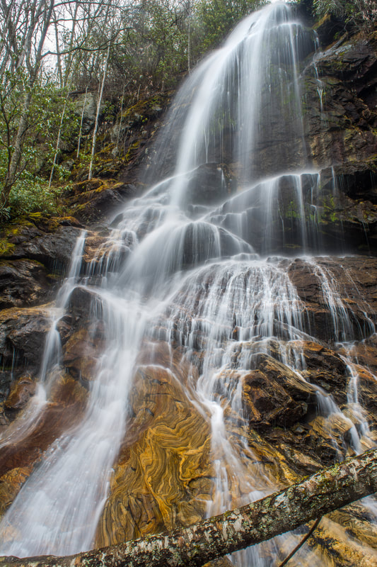
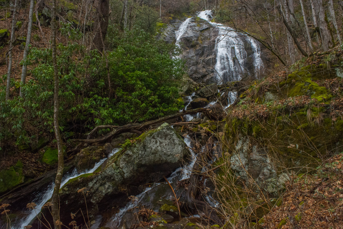
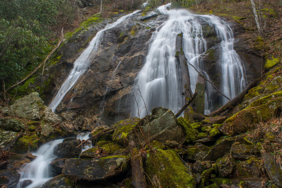
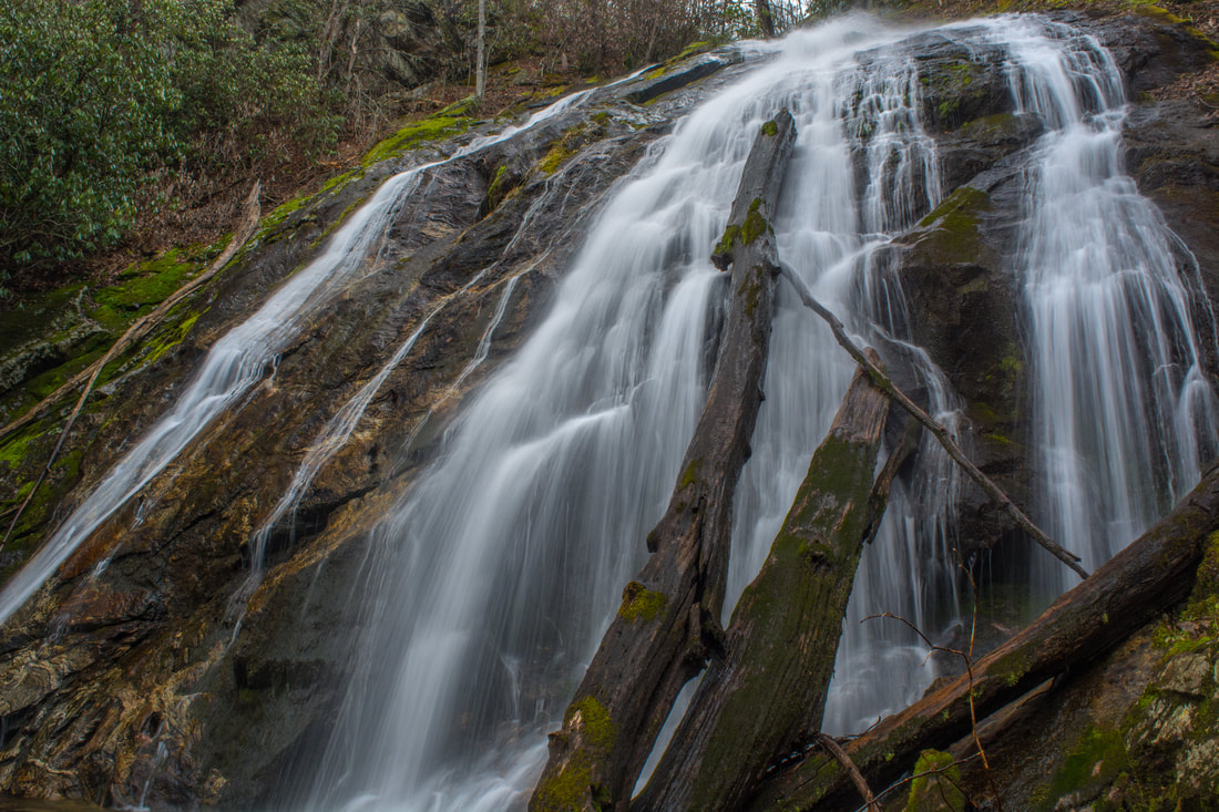
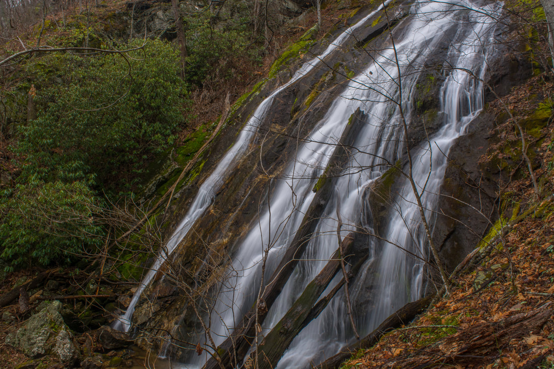
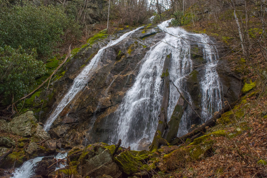
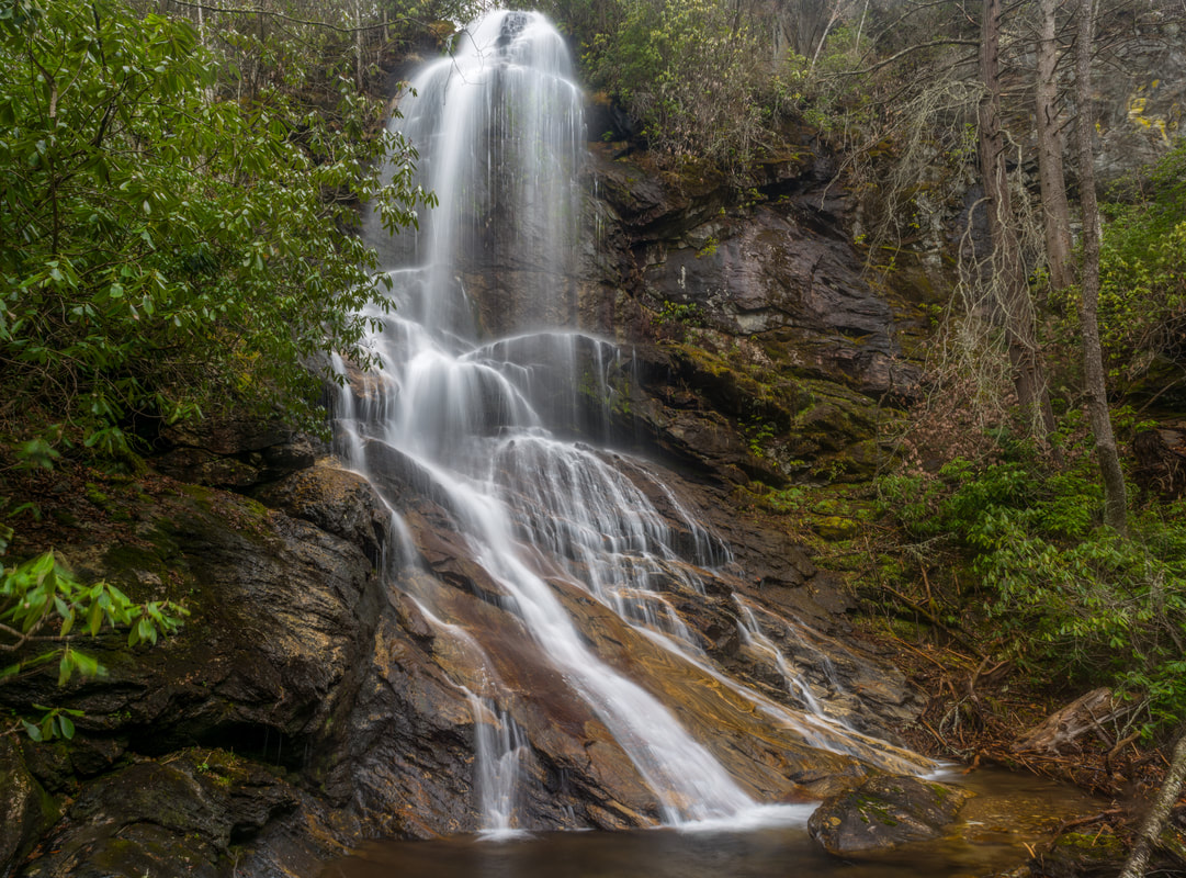
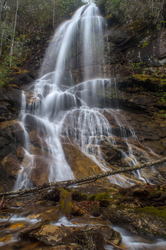
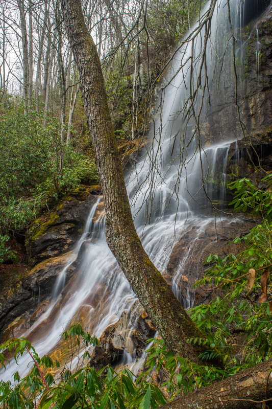
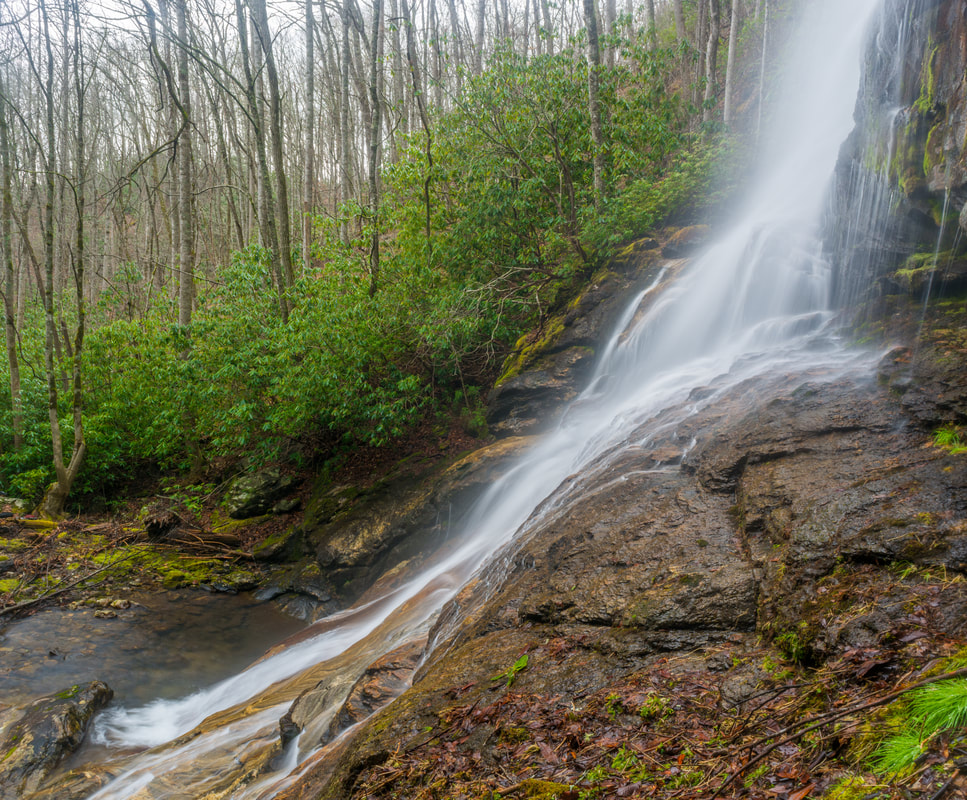
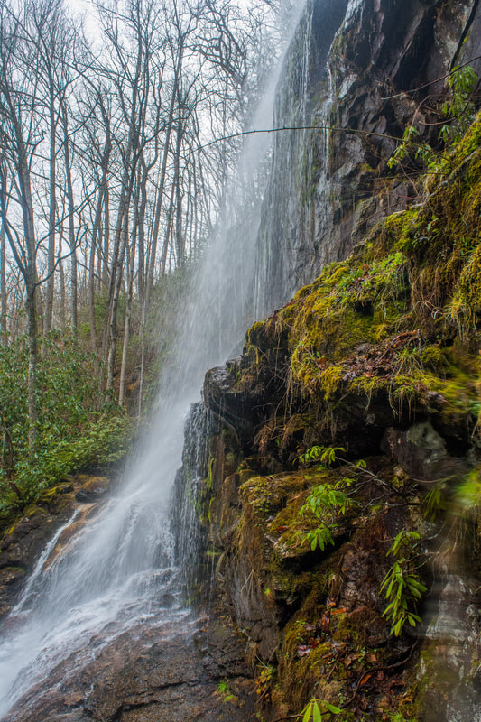
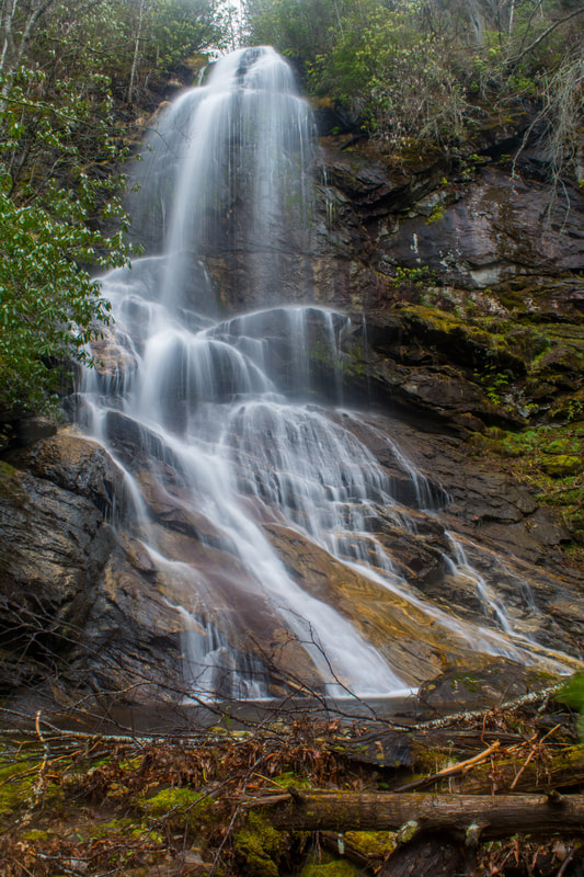
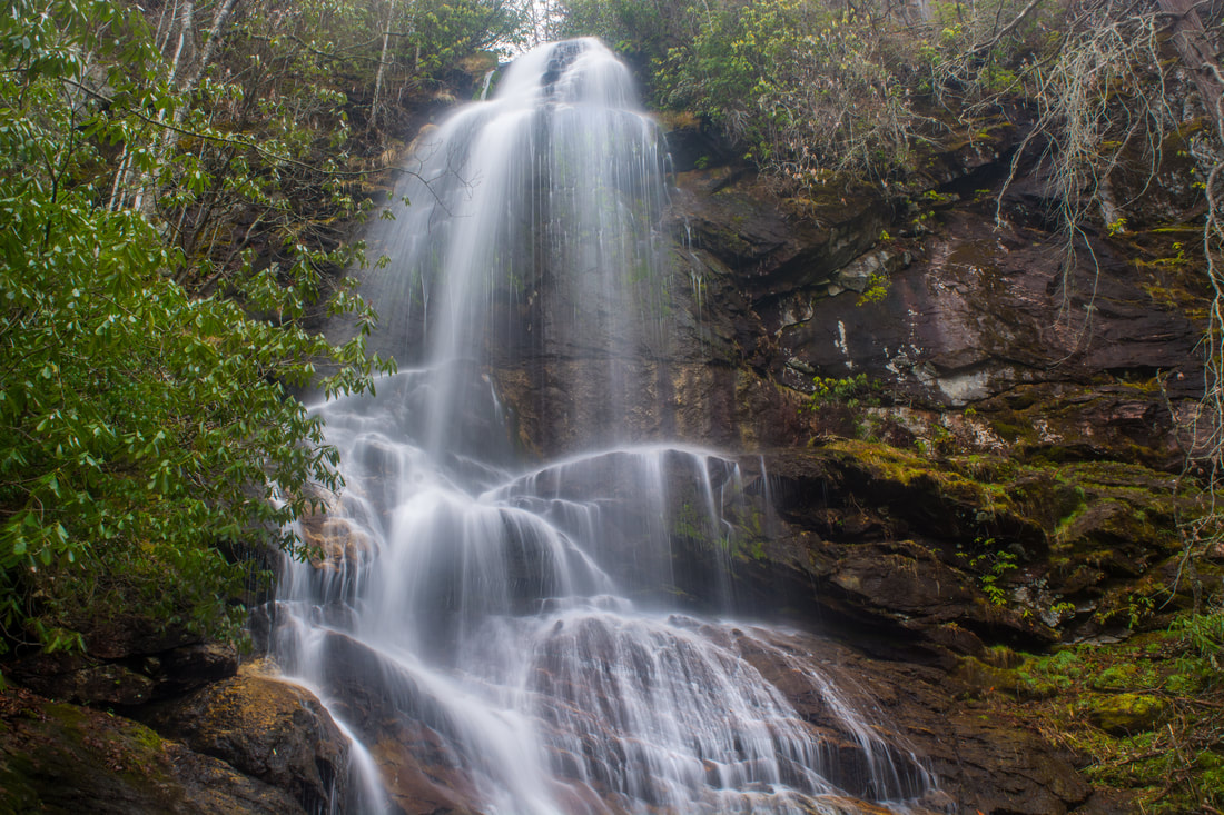
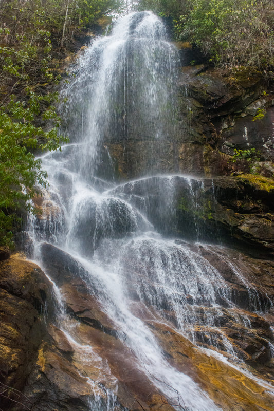
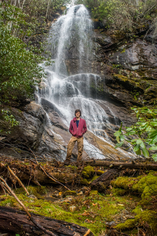
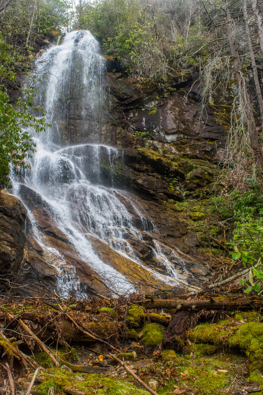
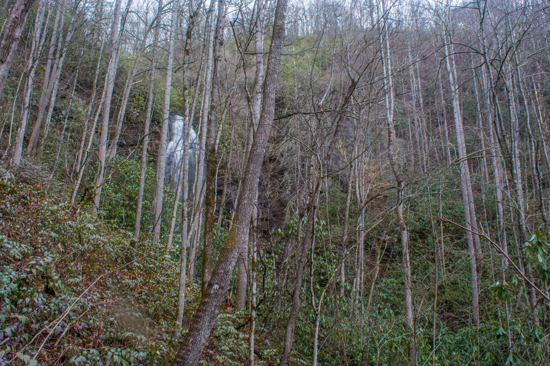
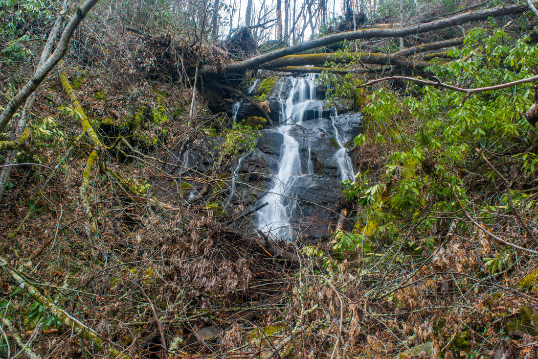
Dozens of streams flow off the slopes of the Plott Balsam Mountains, a high, rugged range of peaks near Sylva. Most of these streams form multiple waterfalls as they cascade into the valleys, but few are as impressive as the pair of waterfalls on Buff Creek. First, Buff Creek comes over a massive cliff to form Upper Buff Creek Falls, a remote and stunning part-free-fall waterfall over 100 feet high. Even taller, Lower Buff Creek Falls comes next as the creek slides steeply down a long, broad rock slab. While the lower falls can look skinny in dry periods, the upper falls is gorgeous in almost any condition! Upper Buff Creek Falls is among the most beautiful waterfalls in southwest North Carolina, but access to it presents problems. Shortly after dropping over the lower falls, Buff Creek enters private property as it comes alongside Buff Creek Road. The only legal way to see the waterfalls is a long hike along old logging roads from the trail to Blackrock Mountain. I visited both waterfalls on Saturday, March 24th, 2018. This is not a typical trail report as I do not have enough information to provide a step-by-step guide for the public route to the waterfalls. Instead, this report serves to acknowledge the existence and beauty of these waterfalls, as well as the possible options for accessing them. 

Update 5/2/18: Andy Kunkle hiked the route to Buff Creek from Blackrock Mountain and verified details about it. With the updated information, it's now clear that this route exists and is in mostly good shape. Andy also discovered two waterfalls on a tributary of Buff Creek that flows down from Blackrock Mountain west of Whiterock Ridge. Scroll down for details! 

Details

Before I describe the possible ways to approach the waterfalls on Buff Creek, I'll first list the locations of both waterfalls. The base of Lower Buff Creek Falls is at N35° 25.579' W83° 09.419'. The base of Upper Buff Creek Falls is at N35° 25.706' W83° 09.392'. Both waterfalls themselves are on the public land of Nantahala National Forest. My beauty rating for Lower Buff Creek Falls is a "7". My beauty rating for Upper Buff Creek Falls is a "10". 

The only way to reach the waterfalls on Buff Creek via public land is to follow a series of old forest roads from the Blackrock Trail. The Blackrock Trail begins at the Blue Ridge Parkway directly across from the access road to Waterrock Knob. The coordinates for the Blackrock Trailhead are N35° 27.379' W83° 08.576'. Since there is no official parking at the trailhead, it might be better to park at the Browning Knob Overlook along the Blue Ridge Parkway a quarter-mile to the east. The trail to Blackrock Mountain is 2.2 miles one way. It is a moderate hike that mostly follows the ridge, crossing Yellow Face Mountain along the way. I have not hiked to Blackrock Mountain this way (I have only hiked to it via Fisher Creek), so please check DWHike's excellent description of the trail. The summit of Blackrock Mountain has stunning panoramic views. Even though the approach to Buff Creek this way is a strenuous hike, it's still an excellent outing with both waterfalls and vistas in the same day. 

To see the waterfalls on Buff Creek, keep following the Blackrock Trail south from the summit of Blackrock Mountain. This is an extremely steep section. In 0.55 miles, the trail loses about 750 feet in elevation! 0.55 miles after the summit of Blackrock Mountain, or about 2.75 miles from the Blue Ridge Parkway, the Blackrock Trail meets a nearly-level, broad forest road at the coordinates N35° 26.333' W83° 10.604'. The junction is at an elevation of about 5040 feet. The Blackrock Trail turns right onto the forest road and eventually joins the West Fork Trail and East Fork Trail in Pinnacle Park. From this intersection with the forest road, do not keep following the Blackrock Trail. Instead, turn left onto the other direction of the forest road. It's unmarked and slightly overgrown, but it's distinct. 

I have not hiked the old forest roads between the Blackrock Trail and Upper Buff Creek Falls. However, Andy Kunkle recently hiked to the waterfalls on Buff Creek this way. He confirmed that the roadbeds exist and are easy to follow all the way, with the exception of a few blowdowns. Still, it's best to not attempt this hike without a good topo map that shows all of the roads (such as the one below). What you need to do is follow the same forest road straight for 2.2 miles. When you reach the unnamed tributary of Buff Creek on the east side of Whiterock Ridge (the tributary that joins Buff Creek just below the upper falls), turn right onto the forest and loosely parallel the tributary for 0.4 miles. You will then join another forest road. Bear right onto the second forest road and follow it for another 0.15 miles to a gradual right-hand curve at the coordinates N35° 25.710' W83° 09.520'. This is the exact place where you should turn left off the road and bushwhack down to Upper Buff Creek Falls. The woods are open but steep. You should be bushwhacking southeastward, In 0.1 miles, reach the Buff Creek tributary again (you might be able to see Upper Buff Creek Falls through the trees here in winter). To the left is a 50-foot sliding waterfall on the tributary at the coordinates N35° 25.724' W83° 09.455'. It's not very scenic due to large amounts of deadfall. To get to Upper Buff Creek Falls, cross the tributary and angle southeast toward Buff Creek. When you swing into the Buff Creek hollow, bear left and follow the creek for a short distance upstream to Upper Buff Creek Falls. The map below shows this route to the falls. 
Picture
The public access to Upper Buff Creek Falls is approximately 11.4 miles roundtrip with about 3000 feet of elevation gain. Although this is a long and strenuous hike, it is probably doable for seasoned hikers with good navigational skills. It's definitely worthwhile. The base of Lower Buff Creek Falls is only 0.2 miles downstream from Upper Buff Creek Falls. If you decide to scramble down to it, make sure to stay on the west side of the creek (River Right). It is an extremely steep scramble, but the woods are not overgrown. Do not go any further downstream from Lower Buff Creek Falls, as private property begins just below the base. 

Rather than going all the way from the Blue Ridge Parkway and Blackrock Mountain, a much easier access to both waterfalls on Buff Creek is from Buff Creek Road at its last crossing of the creek. Unfortunately, the beginning of the route passes through 150 feet of unmarked private property, within sight of houses. One can access Lower Buff Creek falls by following the east (River Left) side of Buff Creek for 0.2 miles from the road, and one could then cross the creek, scramble up the extremely steep slope on River Right, and get to Upper Buff Creek Falls that way. However, you'd definitely be trespassing at the beginning near the road that way, and I can't condone trespassing on private property without permission. I have not talked to local homeowners at the end of Buff Creek Road, so maybe they might give you permission to see the falls - I will leave it to you to find out. With that said, the long access from Blackrock Mountain is definitely worth doing, as Upper Buff Creek Falls is a jaw-dropping waterfall, and the panoramic view from Blackrock Mountain complements it very well. 

​You're also probably wondering where the forest road above Upper Buff Creek Falls leads. Yes, it comes out a gate right at the end of Buff Creek Road. The gate is posted with a 'No Trespassing' sign. As best as I can tell, a short section of the road near its lower end is owned by a real estate investment agency. Maybe if the agency tries to sell the land, public access to Buff Creek can be secured and a parking space can be built at the end of Buff Creek Road. For that to possibly happen, we will also need to alert local conservation groups about the existence of the spectacular, seldom-visited waterfalls on Buff Creek (especially the upper falls). Let's keep our fingers crossed that easier public access to Buff Creek will become a reality one day... 

Let's talk about the beauty of the waterfalls on Buff Creek. Upper Buff Creek Falls is 120 feet high, much of it a vertical drop! The upper tier of the falls is a series of free-falls over a grand cliff. The lower tier is a steep slide into a shallow pool. Dense rhododendron thickets surround the base of the falls. Besides the huge cliff, a remarkable feature of Upper Buff Creek Falls is the colorful, striated gneiss on the waterfall's sliding section. The gorgeous yellow rock adds even more beauty to this breathtaking waterfall. As you explore the falls, note how the big cliff stretches away very far along the mountain on the east side of the creek. 

Lower Buff Creek Falls, while not nearly as spectacular as the upper falls, is a beautiful waterfall as well. It consists of two sliding sections that total to 200 feet in height. The 70-foot upper sliding section is very difficult to see and is unremarkable, but the lower section is impressive, especially during high flow. At those times, the flow of Buff Creek splits into numerous powerful ribbons of water that slide down an enormous rock slab. A jumble of mossy boulders lies at the base of the falls. Although the lower tier of Lower Buff Creek Falls is about 130 feet high, it's slanted such that you can only see the lower 80 feet or so from the base., and the only good view is on the east side of the creek. It's still an impressive sight. 

Many thanks to local waterfaller Paul Albert for telling me about Lower Buff Creek Falls and giving me a lot of insight about access to it, as well as possible access routes to the upper falls. Although Upper Buff Creek Falls had technically been undocumented prior to my visit, Paul had known about the existence of upper falls for years too. Thanks to his help, I was able to lay out a route that led me to see this spectacular pair of falls. ​

When Andy Kunkle visited the waterfalls on Buff Creek, he also discovered two waterfalls on a large unnamed tributary of Buff Creek that flows down from Blackrock Mountain along the west side of Whiterock Ridge. He was able to hear the waterfalls from the old roadbed, but he had to scramble steeply off-trail down to see them. The first one, which he called 10,000 Trillium Falls due to the abundance of trilliums on the slopes above the waterfall, is at the 3880-foot contour and at the coordinates N35° 26' 06.5" W83° 09' 53.8". The second waterfall, which he called Dark Hollow Falls, is a short distance upstream at the 4000-foot contour and at the coordinates N35° 26' 09.8" W83° 09' 55.1". Each waterfall is about 30 feet high and is worth a visit, as long as the water flow isn't very low. Be sure to stay on the east (River Left) side of the stream while visiting these, as the west (River Right) side is private property. 

Pictures & Videos

3 Comments
Jerry Brooks
4/7/2018 03:24:47 pm

First time I’ve seen the falls in over 50 years.
Thanks for putting this out.
They are still as beautiful as I remember.

Reply
Juan Mo Time
11/10/2018 12:06:17 am

The ‘public’ route that you describe takes you through Nature Conservancy property. Don’t you have to get permission to travel across Nature Conservancy property?

Reply
Mark Oleg
11/19/2018 02:00:05 pm

Hi Juan,
This particular Nature Conservancy tract is open to public access per my knowledge. The spectacular Blackrock Mountain Trail already runs through it and is frequently hiked. I did not see any signs restricting access either.
Mark

Reply


Leave a Reply.

    About Me

    Mark Oleg Ozboyd
    I'm an avid outdoor explorer and a hobbyist landscape photographer. I'm 21 years old and have been hiking since 2011. Originally based out of Atlanta, Georgia, I started out by occasionally hiking short trails throughout well-known Georgia State Parks. During 2012 and 2013, I began to expand my trips into adjacent states, as well as into the wilder National Forest areas rather than just State Parks. Throughout the years that followed, as I slowly ran out of popular hiking trails in my area, I began to search for and hike in more seldom-visited areas. Today, you can find me out in the woods every weekend, whether it's on an official trail or bushwhacking through cross-country terrain without any paths. I now attend Washington & Lee University and am exploring Virginia and West Virginia. My other hobbies include chess, science, old music, and meteorology. I have 3 years of amateur weather forecasting experience, having studied a lot of meteorology basics over the years. I am also a student at European School of Music where I learned that music and nature have a lot in common. Listening to good music inspires me to capture nature's beauty on the camera in different aspects that also make me recall many beautiful music pieces that I've heard.​


    Dear readers: I have invested a tremendous amount of time and effort in this website and the Georgia Waterfalls Database the past five years. All of the work that has gone in keeping these websites updated with my latest trip reports has almost been like a full-time job. This has not allowed me to pick up a paid job to save up money for college, and therefore, I I've had to take out loans. If you find the information on this website interesting, helpful, or time-saving, you can say "thanks" and help me out by clicking the button above and making a contribution. I will be very grateful for any amount of support you give, as all of it will apply toward my college tuition. Thank you! 

    Enter your email address to subscribe for trail reports:

    Delivered by FeedBurner


    Picture
    Coming in 2022-2023?

    Other Hiking Websites

    DWHike's Adventures
    Florida's Natural Wonders
    Florida Trailblazer
    Meanderthals
    Mountain Images
    by Bernie Boyer

    North Carolina Waterfalls with
    ​Kevin Adams
    Take-a-Hike!
    Tennessee Landforms
    Waterfall Page
    Waterfall Adventurer
    Zach's Mild Adventures

    Miles Hiked

    Year 1: 540.0 Miles
    Year 2: 552.3 Miles
    ​Year 3: 518.4 Miles
    Year 4: 482.4 Miles
    Year 5: 259.9 Miles

    Archives

    March 2021
    February 2021
    January 2021
    November 2019
    October 2019
    September 2019
    August 2019
    July 2019
    June 2019
    February 2019
    January 2019
    December 2018
    November 2018
    October 2018
    August 2018
    July 2018
    June 2018
    May 2018
    April 2018
    March 2018
    February 2018
    January 2018
    December 2017
    November 2017
    October 2017
    September 2017
    August 2017
    July 2017
    June 2017
    May 2017
    April 2017
    March 2017
    February 2017
    January 2017
    December 2016
    November 2016
    October 2016
    September 2016
    August 2016
    June 2016
    May 2016
    April 2016
    March 2016
    January 2016
    December 2015
    November 2015
    October 2015
    September 2015
    August 2015
    July 2015
    June 2015
    May 2015
    April 2015
    March 2015
    February 2015
    January 2015
    December 2014
    November 2014
    October 2014
    September 2014
    August 2014
    July 2014
    June 2014
    May 2014
    April 2014
    March 2014
    February 2014

    Categories

    All
    Adel
    Adirondack Park
    Alabama
    Alfred A. Ring Park
    Allegheny Trail
    Amicalola Falls State Park
    Anniston Area
    Apalachicola Bluffs And Ravines Preserve
    Apalachicola National Forest
    Apalachicola/Port St. Joe Area
    Apopka
    Appalachian Trail
    Appling
    Art Loeb Trail
    Aska Trail System
    Bakersville
    Balm-Boyette Scrub Preserve
    Balsam Lake Recreation Area
    Bankhead National Forest
    Bartow County Parks
    Bartram Trail
    Basinger
    Beersheba Springs
    Benton
    Benton Mackaye Trail
    Berry College Trail System
    Best Hike
    Big South Fork National Recreation Area
    Black Bear Wilderness
    Black Rock Mountain State Park
    Blairsville
    Blakely
    Blood Mountain Wilderness
    Blowing Rock
    Blue Ridge
    Blue Ridge Parkway
    Boone
    Bradenton
    Bradenton Beach
    Brasstown Bald
    Brasstown Wilderness
    Brevard
    Bryson City
    Buchanan
    Bucks Pocket State Park
    Bulow Creek State Park
    Bulow Plantation Ruins State Park
    Caesars Head State Park
    Caladesi Island State Park
    Calhoun
    Camel's Hump State Park
    Cashiers
    Caspersen Beach Park
    Catfish Creek State Park
    Caves
    CC Putnam State Forest
    Cedar Point Environmental Park
    Chatsworth
    Chattahoochee National Forest
    Chattanooga
    Chattanooga Valley
    Chattooga National Wild And Scenic River
    Cheaha Wilderness
    Cherohala Skyway
    Cherokee
    Cherokee National Forest
    Chiefland Area
    Chillhowee Recreation Area
    Chipley
    Chunky Gal Trail
    Circle B Bar Reserve
    Citico Creek Wilderness
    Citrus Wildlife Management Area
    Clarkesville
    Clayton
    Cleevland
    Cleveland
    Cloudland Canyon State Park
    Cohutta Wilderness
    Collier-Seminole State Park
    Cordele
    Cornelia
    Covington
    Crestview Area
    Crew-land-and-water-trust
    Cullowhee
    Cumberland Trail
    Dahlonega
    Dalton
    Dawson Forest Wildlife Management Area
    Dawsonville
    Dayton
    De Soto National Memorial
    DeSoto State Park
    Dillard
    Double Springs
    Ducktown
    Duncan Ridge Trail
    Dunlap
    Eagle's Rest Park
    Eastpoint
    Econfina Creek Wildife Management Area
    Eglin Air Force Base
    Elizabethton
    Elkins
    Elk Knob Game Lands
    Elk Park
    Ellicott Rock Wilderness
    Ellijay
    Emerson Point Preserve
    Englewood Area
    Enota Retreat
    Erwin
    Falling Waters State Park
    Fayetteville
    Fires Creek Recreation Area
    Fire Tower
    Flint River
    Florence Area
    Florida
    Florida Caverns State Park
    Florida Trail
    Foothills Trail
    Fort Mountain State Park
    Fort Myers Area
    Fort Payne
    Fort Payne Area
    Fort Yargo State Park
    Franklin
    Franklin Delano Roosevelt State Park
    Franklin-Marion State Forest
    Frozen Head State Park
    Gainesville
    Gainesville Area
    Gatlinburg
    George Washington National Forest
    Georgia
    Georgia Veterans Memorial State Park
    Glasgow
    Gorges State Park
    Grandfather Mountain State Park
    Great Smoky Mountains National Park
    Greeneville
    Green River Game Lands
    Gruetli-Laager
    Grundy Forest State Natural Area
    GTM Reserve
    Guana River Wildlife Management Area
    Hayesville
    Helen
    Hiawassee
    High Falls State Park
    Highlands
    Highlands Scenic Highway
    Hillsborough River State Park
    Hinson Conservation & Recreation Area
    Historic Sites
    Honeymoon Island State Park
    Hot Springs
    Huntington
    Inverness Area
    Jackson
    Jasper
    Jefferson National Forest
    Joan M. Durante Park
    Jonathan Dickinson State Park
    Jones Gap State Park
    Joyce Kilmer Slickrock Wilderness
    Joyce Kilmer - Slickrock Wilderness
    Juniper Prairie Wilderness
    Kelly Park
    Keown Falls Recreation Area
    Kolomoki Mounds State Park
    LaFayette
    Lake City Area
    Lake George Wild Forest
    Lake June-in-Winter State Park
    Lakeland Area
    Lake Placid
    Lake Russell Wildlife Management Area
    Lake Wales Ridge State Forest
    Laurel Fork North Wilderness
    Leffis Key Preserve
    Leon Sinks Geological Area
    Lexington
    Lineville
    Linville
    Linville Gorge Wilderness
    Lithia Springs
    Little Frog Wilderness
    Little Manatee River State Park
    Little River Canyon National Preserve
    Longboat Key
    Long Trail
    Lookout Mountain
    Lookout Mountain Battlefield
    Lovingston
    Lula Lake Land Trust
    Lumpkin
    Maggie Valley
    Manatee Springs State Park
    Marianna Area
    Mark Trail Wilderness
    Marlinton
    Mccaysville
    McMinville
    Mentone
    Middlesex
    Mistletoe State Park
    Monongahela National Forest
    Montreat
    Mountain Bridge Wilderness Area
    Mountain City
    Mountains To Sea Trail
    Mountains-to-Sea Trail
    Mount Rogers National Recreation Area
    Myakka River State Park
    Myron B. Hodge City Park
    Nantahala National Forest
    Naples
    Naples Area
    Natural Bridge State Park
    Neal Preserve
    New Castle
    Newport
    New River Gorge National Park
    New York
    North Carolina
    Ocala Area
    Ocala National Forest
    Ocean-to-Lake Trail
    Oconee State Park
    Oconee Station Historic Site
    Okaloacoochee Slough State Forest
    Oldsmar
    Oneida
    Orlando Area
    Ormond Beach
    Oscar Scherer State Park
    Oxford
    Palatka
    Palmetto Trail
    Panama City Area
    Panthertown Valley
    Parrish
    Paynes Creek Historic State Park
    Peaks Of Otter Recreation Area
    Pigeon Crockford Mountain Wildlife Management Area
    Pigeon-Crockford Mountain Wildlife Management Area
    Pigeon-Crockford Wildlife Management Area
    Pine Mountain
    Pinhoti Trail
    Pinnacle Park
    Pisgah Civitan Park
    Pisgah National Forest
    Pittman Center
    Pond Mountain Wilderness
    Ponds/Lakes
    Prentice Cooper State Forest
    Providence Canyon State Park
    Pumpkintown
    Quick Point Nature Preserve
    Raven Cliffs Wilderness
    Reed Bingham State Park
    Reliance
    Rice Creek Conservation Area
    Riverview Pointe Preserve
    Robbinsville
    Robinson Preserve
    Rock Creek Gorge Scenic Area
    Rock Island State Park
    Rome
    Rosman
    Sale Creek
    Salem
    Salt Springs
    Saluda
    Santa Rosa Beach
    Sarasota
    Sarasota Area
    Savage Gulf State Natural Area
    Scenic Views
    Scottsboro Area
    Sebring Area
    Sewanee
    Sheltowee Trace Trail
    Shining Rock Wilderness
    Signal Mountain
    Sipsey Wilderness
    Sky Valley
    Smithgall Woods State Park
    Snowbird Backcountry Area
    Soddy Daisy
    Soddy-Daisy
    Sopchoppy
    South Carolina
    South Cumberland State Park
    Southeastern Cave Conservancy
    Southern Nantahala Wilderness
    Sparta
    Sprewell Bluff Park
    Spring City
    Spring Hill
    Springs
    Spruce Pine
    Standing Indian Backcountry Area
    St. Augustine
    St. George Island State Park
    St. Joseph Bay State Buffer Preserve
    St. Marks Area
    St. Marks National Wildlife Refuge
    Stone Mountain
    Stone Mountain Park
    Suches
    Sumatra
    Sumter National Forest
    Suwannee River
    Swallow Creek Wildlife Management Area
    Sweetwater Creek State Park
    Sylva
    Talladega National Forest
    Tallahassee Area
    Tallulah Falls
    Tallulah Gorge State Park
    Tampa Bay Area
    Tate City
    Tate's Hell State Forest
    Tea Creek Wildlife Management Area
    Tellico Plains
    Tennessee
    Thomaston
    Toccoa
    Topsail Hill State Park
    Torreya State Park
    Townsend
    Tracy City
    Tray Mountain Wilderness
    Trenton
    Triple Creek Preserve
    Troutdale
    Unaka Mountain Wilderness
    Upper Tampa Bay County Park
    Venice
    Vermont
    Virgin Falls State Natural Area
    Virginia
    Virginia Outdoors Foundation
    Vogel State Park
    Wakulla Springs State Park
    Waleska
    Walhalla
    Wartburg
    Water Features
    Waynesville
    Weedon Island Preserve
    Weeki Wachee Preserve
    Wekiwa Springs State Park
    West Palm Beach Area
    West Virginia
    Whitehall
    White Springs
    Winder
    Withlacoochee State Forest
    Young Harris

    RSS Feed

TRAIL REPORTS

Hikes in Alabama
​Hikes in Florida
Hikes in Georgia
Hikes in North Carolina
Hikes in South Carolina
Hikes in Tennessee
Hikes in Virginia

Hiking Resources

Alabama Resources
​
Florida Resources
Georgia Resources
North Carolina Resources
​South Carolina Resources
​
Tennessee Resources

Other

Contact
Map of Hikes
Alphabetical List of Hikes
Southeast Nature Society
© COPYRIGHT 2014-2018
​ALL RIGHTS RESERVED.
Important: I disclaim any responsibility for any damage or personal injury that may occur as a result of the activities and information found on this website. All outdoor activities, especially off-trail hiking, are done at your own risk. Never hike or head into that area that may be above your fitness or experience level.
  • Home
  • Trail Reports
    • Best Hikes
    • Hikes with Scenic Views
    • Hikes with Water Features
    • Alabama
    • Georgia
    • Florida
    • North Carolina
    • South Carolina
    • Tennessee
    • Vermont
    • Virginia
  • Map
  • Hike List
  • Testimonials
  • Resources
  • Contact Us
  • Southeast Nature Society
    • Our Team
  • Georgia Waterfalls Database