HIKING THE APPALACHIANS AND BEYOND
  • Home
  • Trail Reports
    • Best Hikes
    • Hikes with Scenic Views
    • Hikes with Water Features
    • Alabama
    • Georgia
    • Florida
    • North Carolina
    • South Carolina
    • Tennessee
    • Vermont
    • Virginia
  • Map
  • Hike List
  • Testimonials
  • Resources
  • Contact Us
  • Southeast Nature Society
    • Our Team
  • Georgia Waterfalls Database

Cohutta Wilderness: Jacks River Falls via Rice Camp Loop, Chatsworth, Georgia

4/4/2015

7 Comments

 
Picture
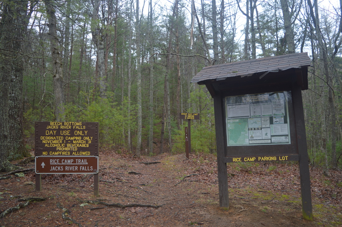
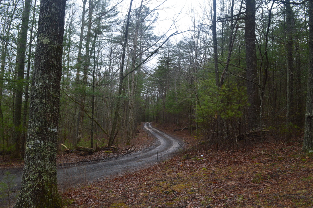
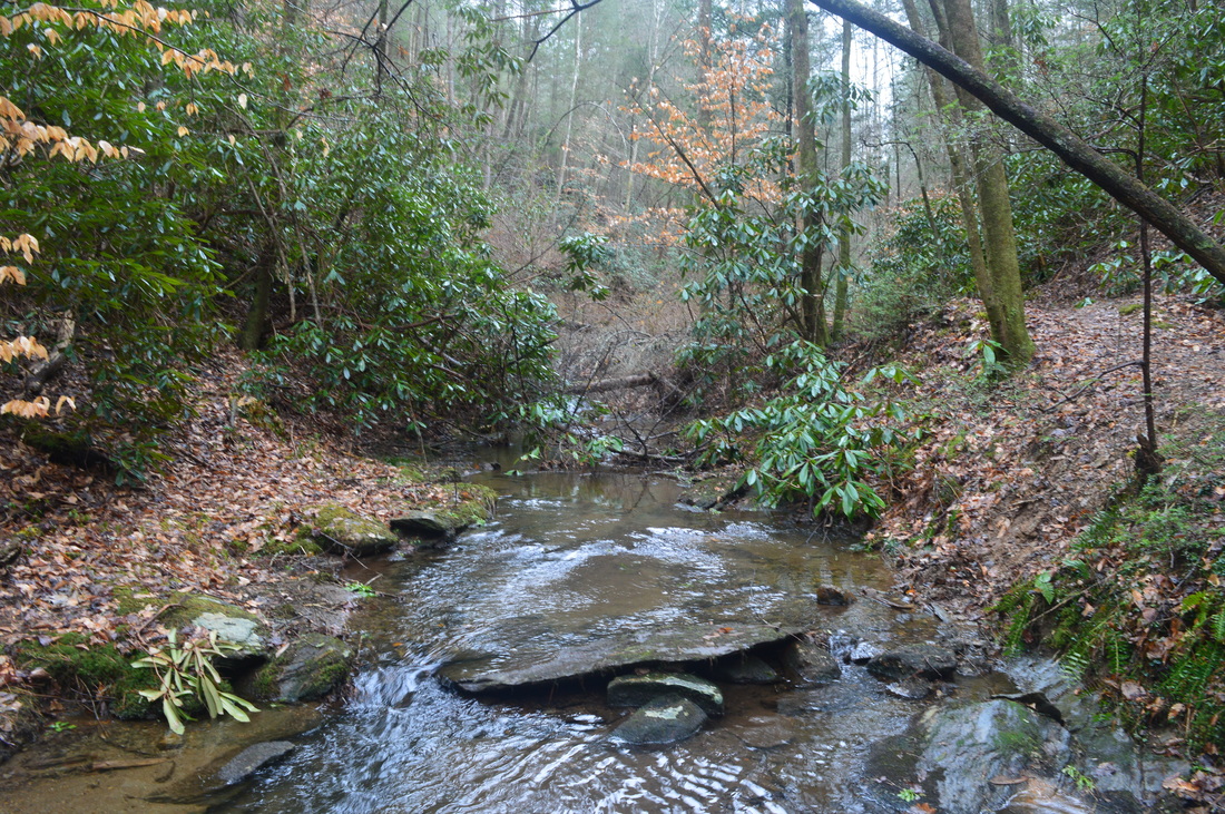
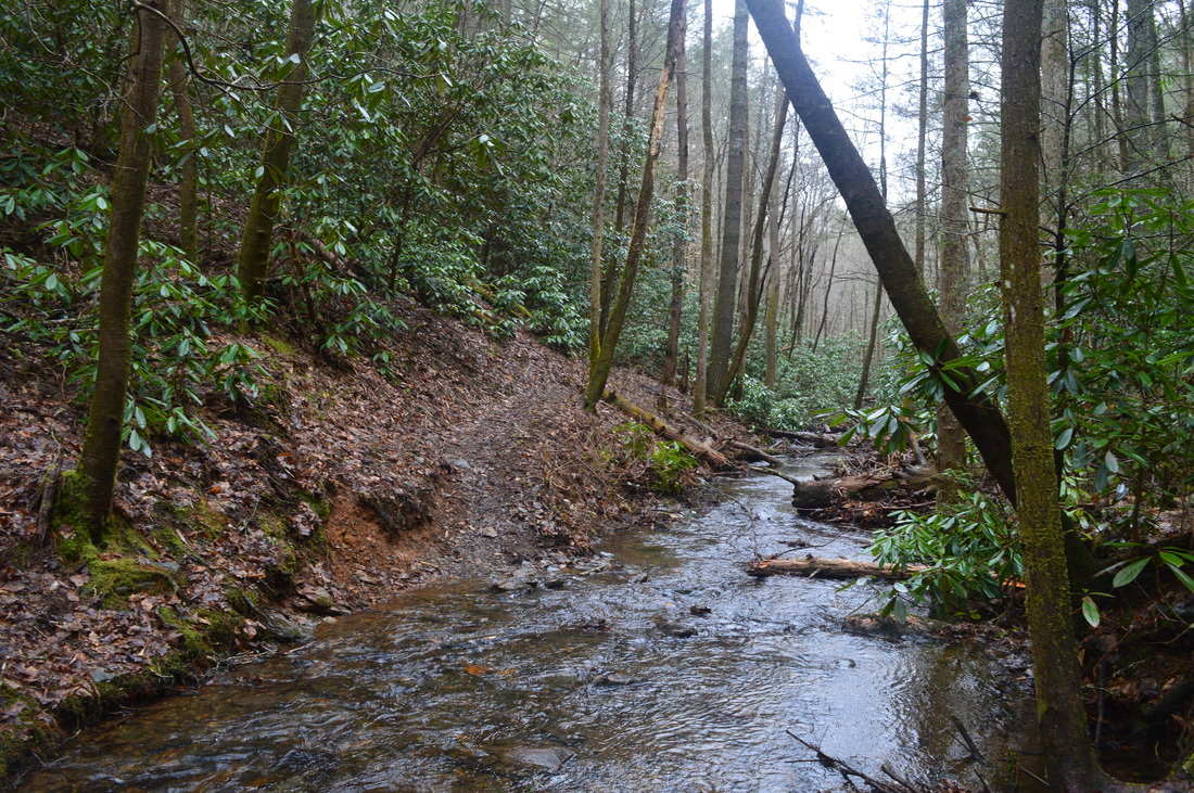
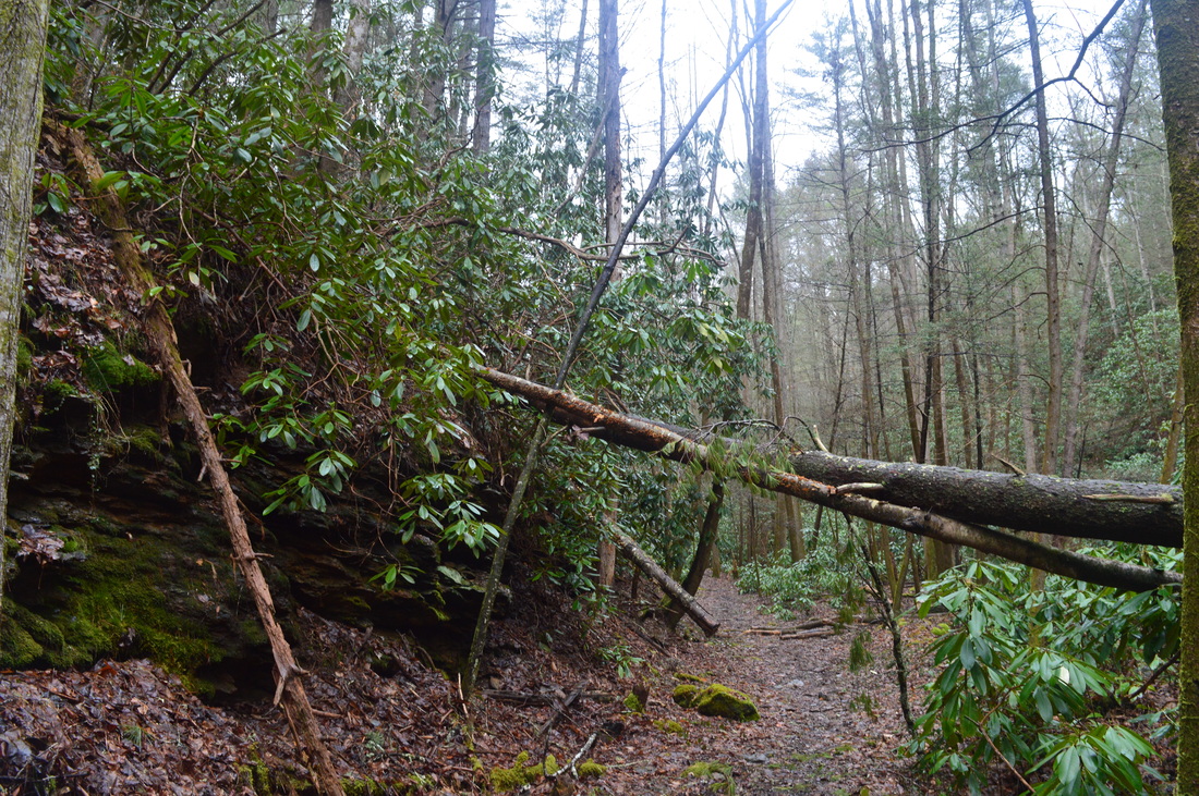
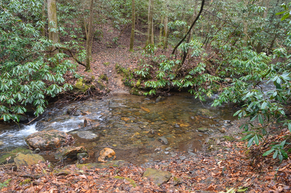
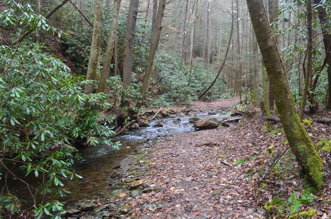
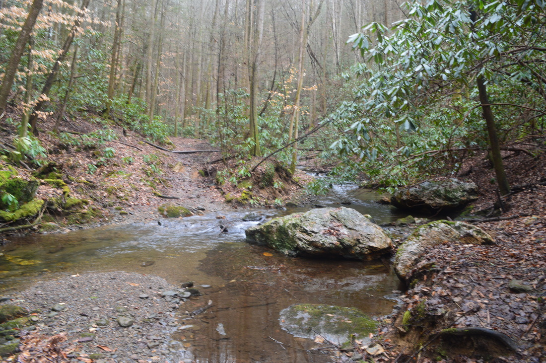
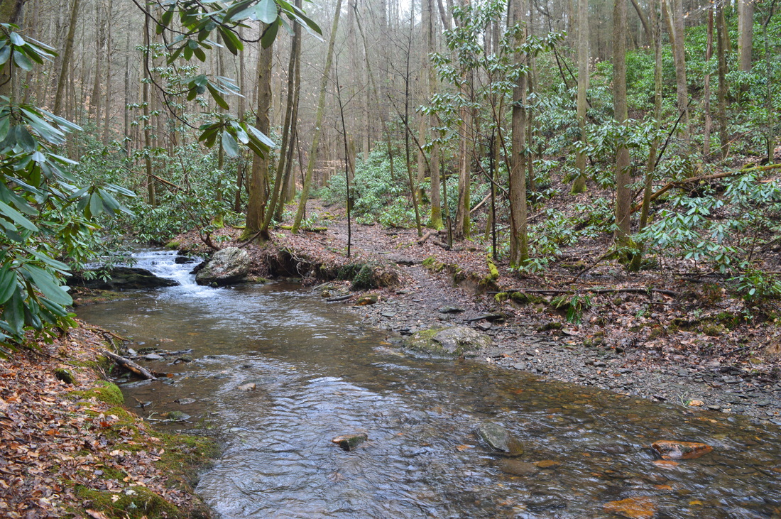
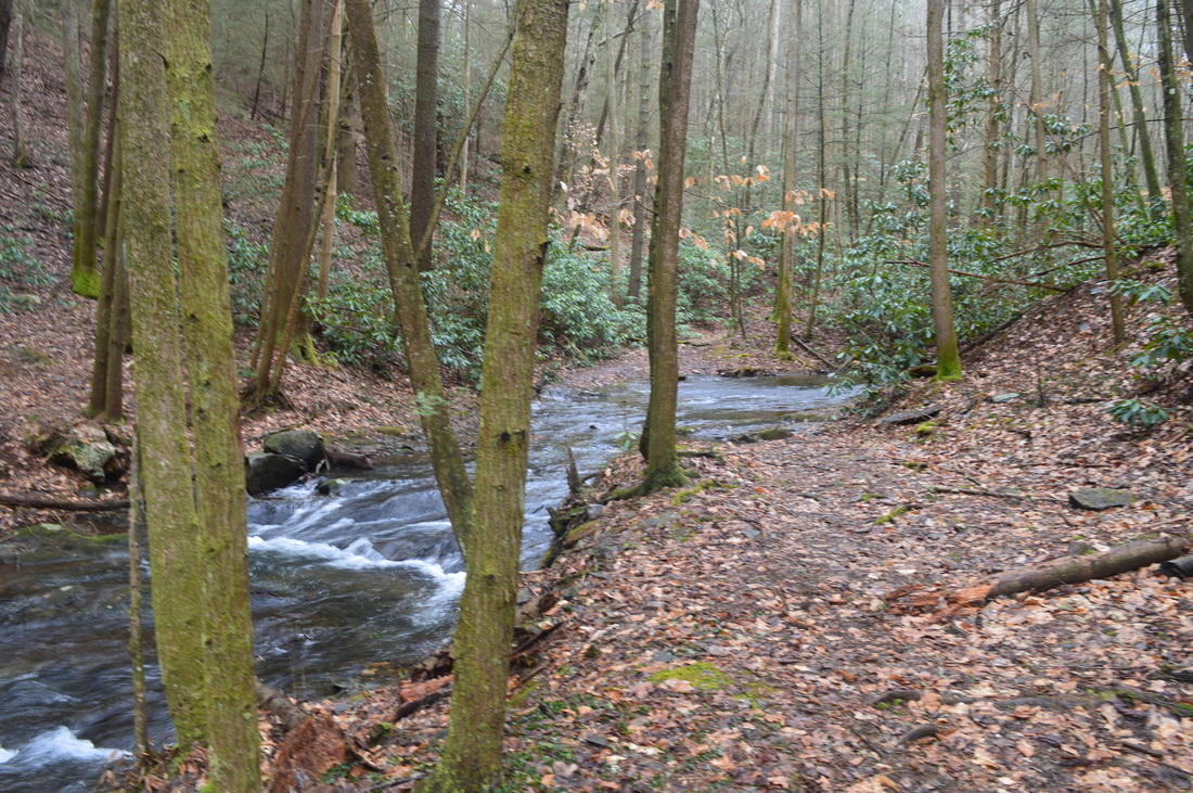
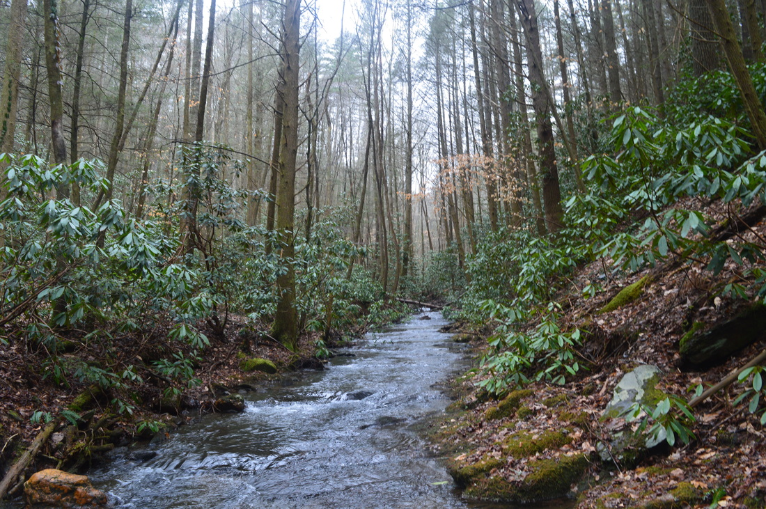
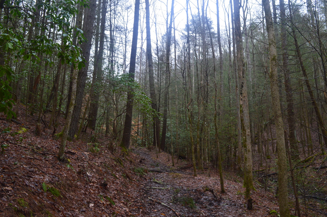
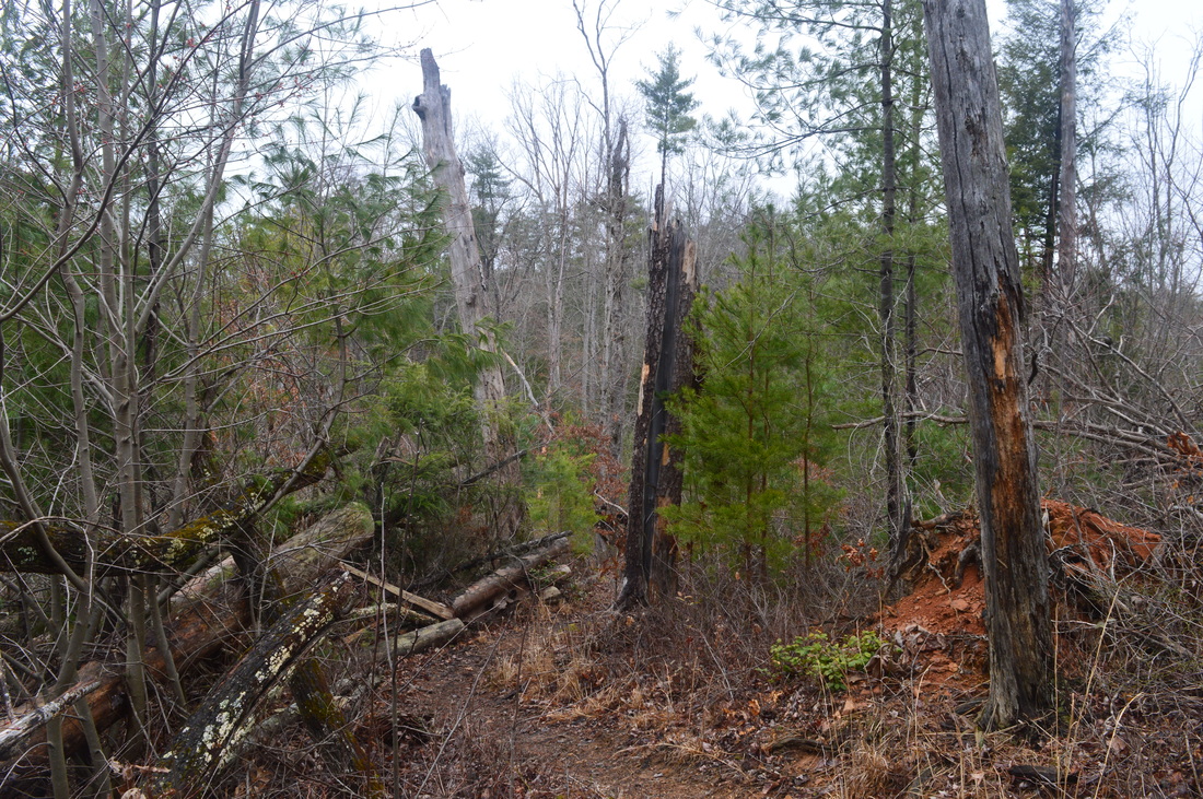
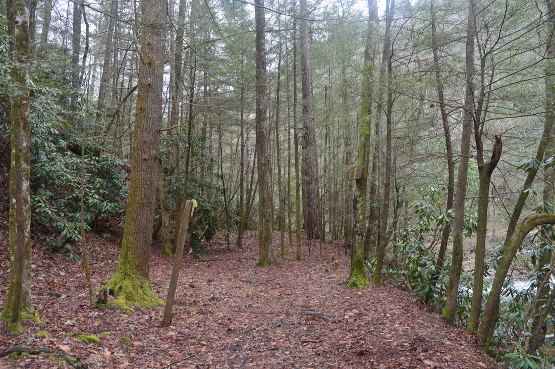
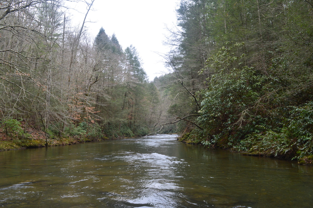
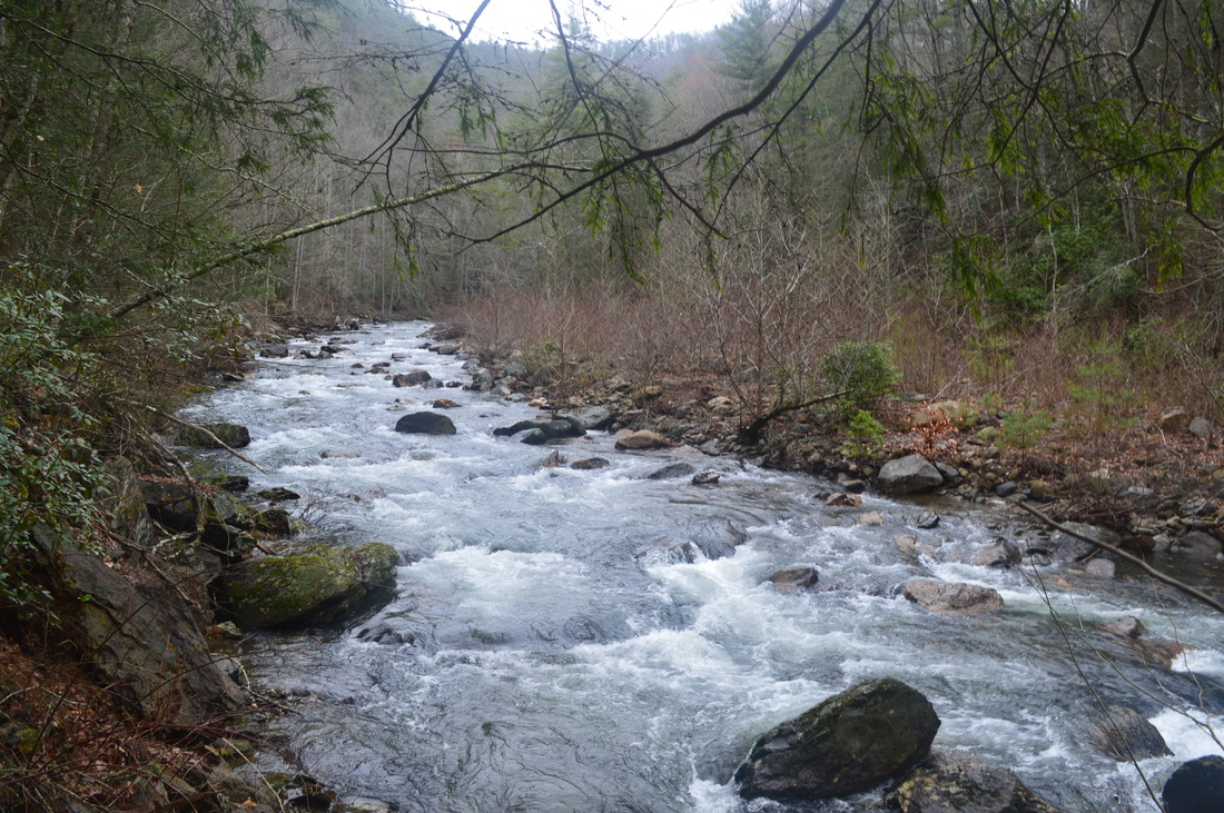
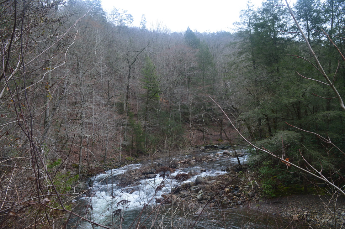
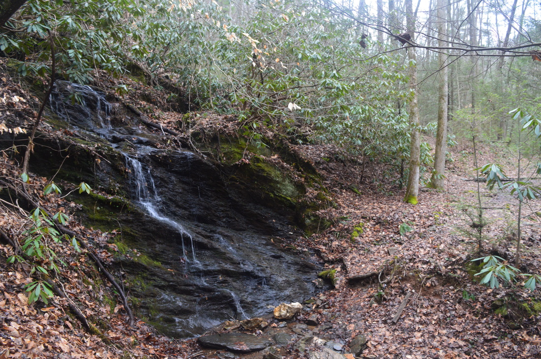
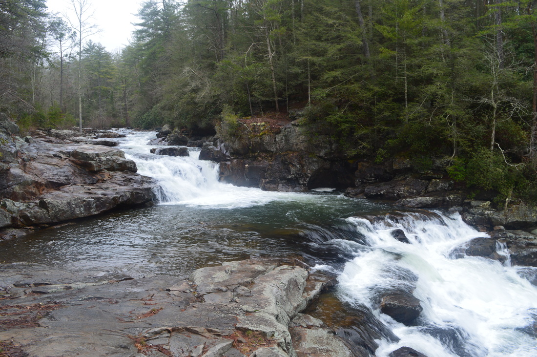
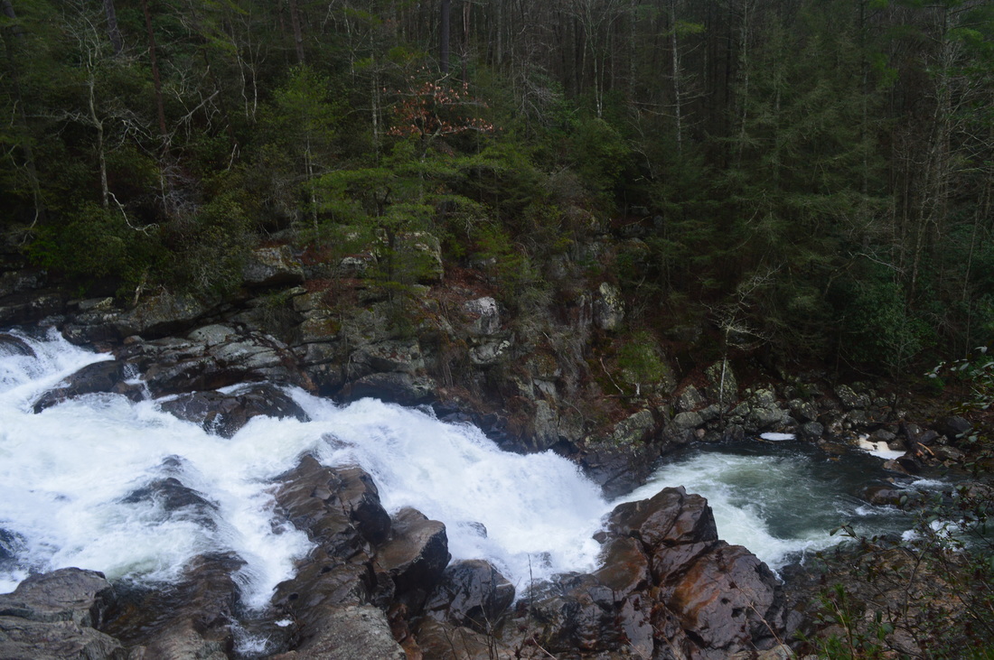
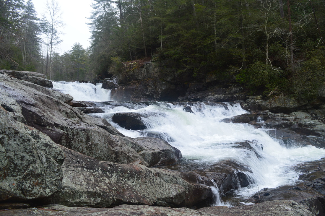
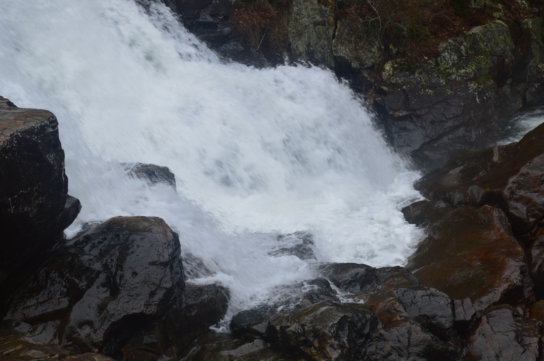
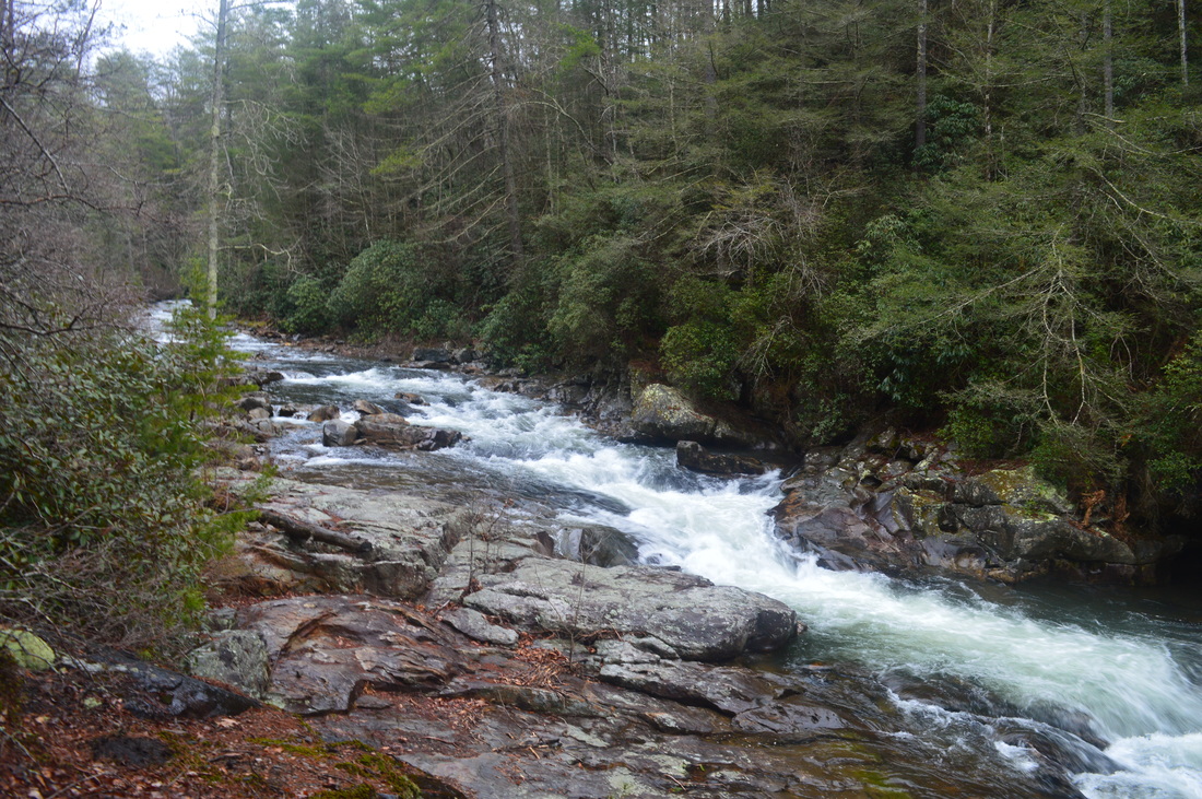
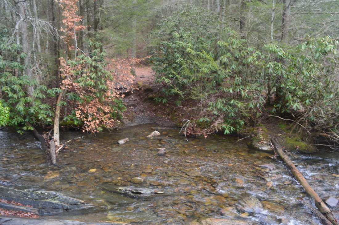
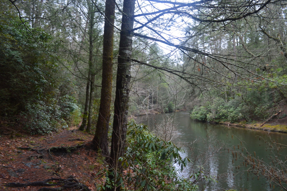
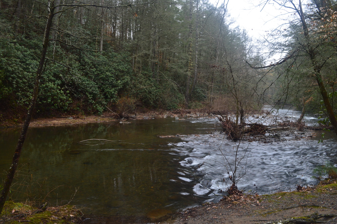
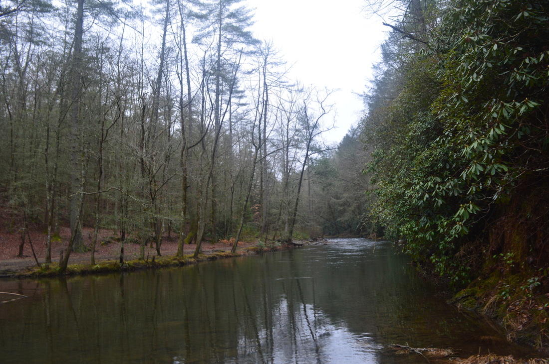
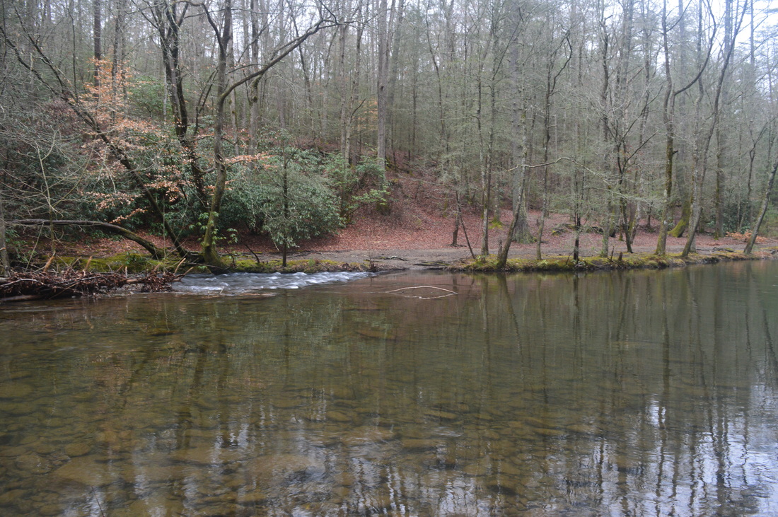
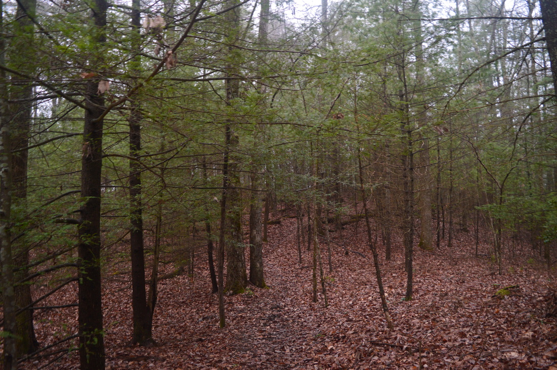
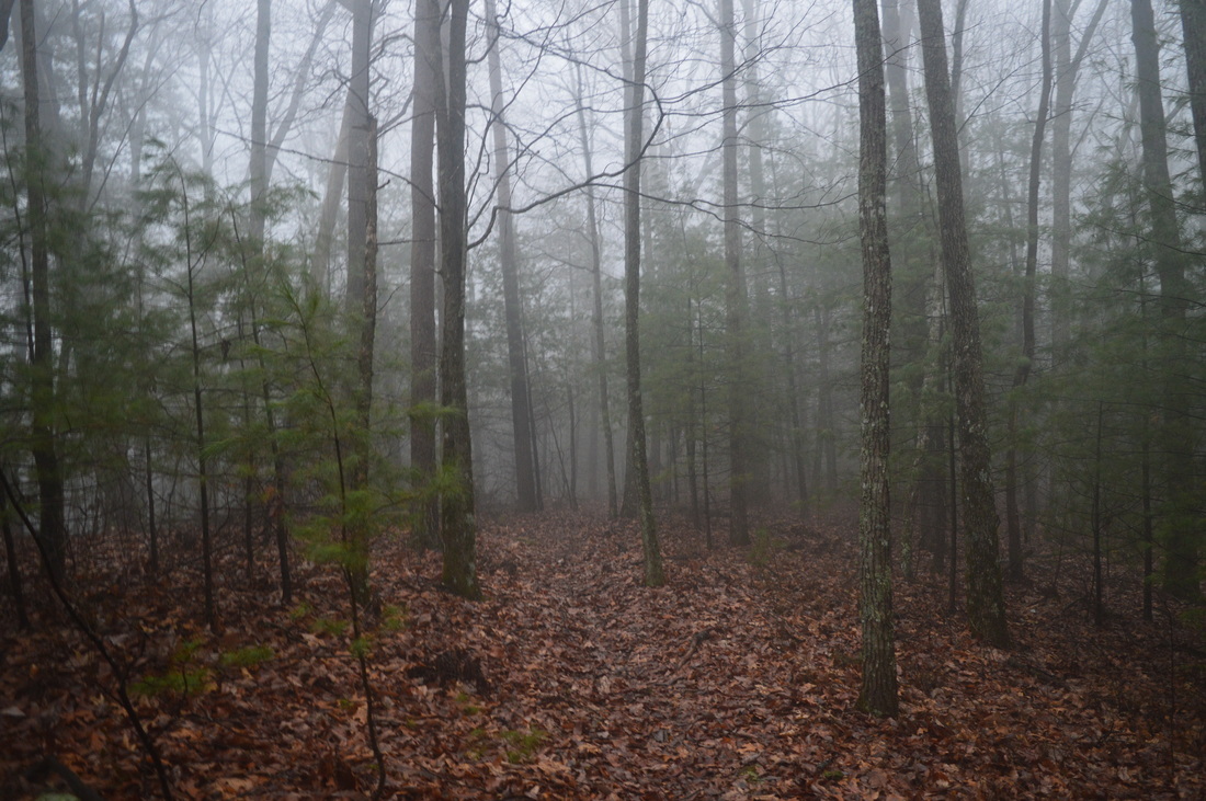
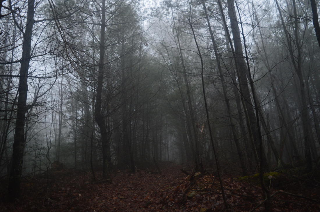
The Jacks River is a turbulent waterway that is the main linear focus of the northern Cohutta Wilderness. The Jacks River Trail travels through the wilderness from the river's headwaters near Dally Gap to the wilderness boundary and the place where Jacks River flows into the Conasauga River in Alaculsy Valley. With 42 fords, the trail is the wettest trail in the Cohutta Wilderness, but also the most scenic, passing through a gorge and past a large waterfall. On this hike, you'll have a chance to experience two fords of the Jacks River, as well as see Jacks River Falls - one of the most powerful waterfalls in Georgia. This hike occurred on Saturday, March 14th, 2015. My plan was to hike the Rice Camp Loop clockwise. I would first take the Rice Camp Trail to the Jacks River. From there, I would take the Jacks River Trail upstream, stopping by Jacks River Falls long the way. Next, I would take the Hickory Ridge Trail and follow it to its terminus at the East Cowpen Trail near Buckeye Mountain. I would finish by taking the East Cowpen Trail downhill back to the trailhead.

R/T Length of Trail: 11.2 Miles
Duration of Hike: 8:00
Type of Hike: Loop
Difficulty Rating: 7 out of 10
Pros: Most of the hike is on groomed trails
Cons: Many fords of Rice Camp Branch and Jacks River, including one extremely difficult and potentially dangerous ford of Jacks River; very steep uphill sections on Hickory Ridge Trail; no camping allowed in Jacks River Falls/Beech Bottoms area
Scenic Views: None
Water Features: Jacks River Falls - 9 stars
Best Season(s) to Hike: Spring; Summer
Trail Blaze Color(s): None; Some Jacks River fords may have a faded blaze
Beginning Point: Rice Camp Trailhead
Directions: From Chatsworth, GA: Follow US Route 411 North for about 13 miles. In Cisco, turn right onto Old Highway 2. The road will turn gravel shortly. Follow it for 7.6 miles, and then, turn right onto Forest Service Road 51, which is the road leading to the Rice Camp Trailhead. Follow this road for 4.9 miles to the dead-end and parking area. This road is generally in good condition, but due to two car fords of Jigger Creek, you will probably need a high-clearance vehicle to reach the trailhead. There are also a couple small muddy areas. 
Picture
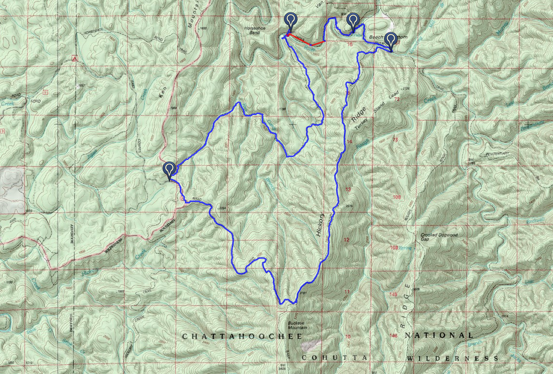
My GPS device malfunctioned during much of this hike, and for this reason, I had to manually edit my map. I drew by hand a line for the approximate location of the trail, where my GPS device didn't record. Thus, the map is not interactive. If you would like to see the interactive but uncompleted version of this hike's map, please click here. 
This is another hike which is only for experienced hikers, but for a completely different reason from my previous trail report. On this hike, there are 11 fords - 9 of Rice Camp Branch and 2 of Jacks River - and the first ford of Jacks River is extremely difficult and I would say potentially dangerous. The first ford of Jacks River is up to waist deep in some areas (although could be shallower in normal water conditions), and consists of large, slick, underwater rock slabs. These rock slabs are not even flat; many of them are angled or uneven, and it is extremely hard to make this ford because of the slippery conditions. Hiking poles are a must, and even with them, it's far from a guarantee that you can make it across. If you plan to attempt this ford, you must have river crossing skills and also, you must know how to swim, in case you end up falling into the deep river. With this said, most of the rest of the hike does not have any problems, as the other fords are all fine, and are just a nuisance. The only other problem is a STEEP climb on the Hickory Ridge Trail, that can be unpleasant after 6 miles and all the fords. But the rest of the hike does not require any special navigational or other hiking skills, so if you know for sure you can ford the river, then you can do this hike. Enough with the warnings now - let me get to the description. 


Two trails leave the Rice Camp Trailhead: the East Cowpen Trail continues uphill following an old roadbed beyond the turnaround, and the Rice Camp Trail leaves left, downhill from the turnaround. You will take the Rice Camp Trail and return by the East Cowpen Trail. As you start this hike, a thought might come up n our mind: if you are now going downhill, and the return trail would be downhill too, there will be a climb somewhere! And that's exactly why I put a difficulty rating of 7 for a generally easy hike. The 3 steep miles of the Hickory Ridge Trail make up for the easiness of the rest of the hike. In any case, for now, keep going downhill on the Rice Camp Trail. Within a quarter mile from the start, a small stream takes shape to the right of the trail. The stream keeps growing gradually as small feeder streams add in their weight from the left and right. The first crossing of the hike occurs at 0.7 miles, and is over the small stream. During the high water conditions in which I was here, this crossing could be crossed dry-shod, but just barely. What's the point anyway, when wet fords lay ahead? There are two more crossings of the stream. Then, at 0.9 miles, the stream drops into Rice Camp Branch, and the trail turns right to follow Rice Camp Branch upstream. At the turn, watch for a small sliding waterfall on the left. It can be a nice one after rain. Shortly afterwards, make the first out of nine fords of Rice Camp Branch. Perhaps all 9 fords can be done dry-shod during normal water levels, but when I was here, all of them were fords. Over the next mile, the fords of Rice Camp Branch come in quick succession as the trail crosses from bank to bank. Some are deep, some are not - the deepest was the last one, around knee deep. After this, at 1.9 miles, a feeder stream comes in from the left. Cross the stream, and then, switchback sharply to the left and now follow the small stream. This is the start of a short uphill section. At 2.1 miles,you will cross this small stream and then continue a gradual ascent, reaching a gap in a low ridge at 2.4 miles. 


From the gap, it gets a bit confusing. There are several different paths heading in different directions. Take the one on the left, and then bear right. The next half-mile of the trail is a bit strange - the trail winds between hills and crosses muddy drainages, without any clear indication of the destination. The terrain here reminds of the Piedmont more than of the mountains. At around 2.9 miles, the trail starts following a low ridge with some winter views. This area has been severely impacted by hurricane damage, but surprisingly, there are almost no blowdowns on the trail. A lot of trees were cut and moved off the trail. At 3.3 miles, the trail suddenly begins a steep descent down to the Jacks River, with few switchbacks. This section can be a bit hard if climbing it instead of descending it, although still better than Hickory Ridge. A small feeder stream on the right can be heard as the trail approaches the Jacks River. The Rice Camp Trail ends at the Jacks River Trail at 3.5 miles. Turning left will eventually bring you to Alaculsy Valley; turning right will bring you to Jacks River Falls and eventually Dally Gap. This hike follows the Jacks River Trail eastbound, so turn right. On the left, there's a large island in the river, separated from the mainland by a rocky, wet-weather channel. The trail will cross the feeder stream that it followed a bit earlier. At 3.6 miles, reach the Jacks River and make your first ford. If you are unsure of whether you can make this ford, this is a good place to turn around. Do not proceed without hiking poles. The ford took me nearly 30 minutes to complete, including taking a few pictures. The first part of the ford is the deepest but also the easiest with a soft riverbed - 2/3 of the ford, which come after the beginning, consist of rock slabs that are extremely slippery, even though it's shallower here. If you do make it across, then you won't encounter any more problems of this sort throughout the rest of the hike. On the other bank, the trail enters the Jacks River Falls/Beech Bottoms camping closure area. This area has been recently closed to camping for it to recover, as it was damaged too much. This area is only along the part of the hike between the two fords of Jacks River. Camping is allowed throughout the rest of the hike after this area.


The next section of the hike is also one of the most scenic sections. As the Jacks River Trail traces an old railroad bed upstream, there are many powerful rapids and small waterfalls on the Jacks River. After heavy rains, there can be several scenic sights along this stretch of the trail. After following the river for some time, the trail will rise well above it, crossing several small streams cascading off the steep slopes on the left. By 4.6 miles, the trail is so far above the river that vegetation significantly decreases the view of the river. But by the time you hear a large roaring sound, it means Jacks River Falls is around the corner - the sound is unmistakable. Reach Jacks River Falls at 4.7 miles. The 80-foot waterfall, cascading into a rock amphitheater and ending in a large pool, can be an impressive sight after heavy rains. Both of my trips to this falls were after heavy rains, and during those conditions, the whole waterfall is one big mass of whitewater , with drops of water flying almost as far as the trail. You might ask a question, "How do you get to the base of the falls?" That's a good question, and one which I didn't find the answer to. I was able to scramble down the cliff to a point on the side of the falls, but I couldn't see any easy way to get to the base. Some serious rock scrambling might be required. Maybe it would be easier to get off the trail somewhere earlier, when it followed the river, and then try to follow the river upstream to the falls. I'm not sure if that option would be possible after heavy rains though. 


After Jacks River Falls, the trail returns to following the river right along its bank. There are more rapids here. At 4.8 miles, reach Beech Bottoms Creek and ford it. Use caution descending down the rock slabs besides the creek. Again, during times of normal water flow, this may be a dry crossing, but when I was here, there was no way to cross it dry-shod. It seems like Beech Bottoms Creek brought the whitewater rapids to the river, because beyond the ford, the river became calm and deep, with few rapids. The trail here is level and easy as it gradually rises slightly above the river. After several more closed camping spots, reach a junction with the Beech Bottoms Trail at 5.4 miles. The Beech Bottoms Trail heads into Tennessee to its Big Frog Road Trailhead. The Beech Bottoms Trail is a good winter option for a hike to Jacks River Falls, as it's a relatively dry trail. Right after the junction, there is an unmarked junction with the Hickory Ridge Trail, although you may spot a sign for it nailed on a tree below the Jacks River Trail. The Hickory Ridge Trail drops right into a flat, while the Jacks River Trail continues straight. In the flat, there is a sign for the trail. Make the second and last ford of the Jacks River here, and also the last ford of any kind on the hike. After such a difficult first ford, this is a pretty easy ford. The footing is good and it's only knee deep. After the ford, follow a gravel bar along the ban of the river, and pay attention to where the trail leaves it and climbs to slightly higher ground to keep following the river. Then, watch for the trail turning sharply left, while a small stream, as well as the main river, lie ahead. Shortly cross the small stream and begin a long, often steep ascent to Buckeye Mountain. There are probably good winter views throughout the trail, but I couldn't tell because it was fogged in most of the time. After the first steep pitch, there are no steep areas for some time as the trail gradually keeps climbing up the ridge, but the steep pitches will start right when you think you are almost there. And from about halfway into the trail, the rest of the trail, whenever it's uphill, it's going to be steep. When you finally reach the end of the trail near the summit of Buckeye Mountain at 8.8 miles. You can now breathe a sigh of relief - no more climbing the rest of the hike. The East Cowpen Trail continues straight from here and continues climbing on its way to the summit of Buckeye Mountain and later Cowpen Mountain. The East Cowpen Trail also bears right, downhill, and this is where you're headed from here. The rest of the hike is downhill, and most of it is not steep. there will be a couple blowdowns, though, and several campsites. You will leave the Cohutta Wilderness at 10.9 miles, and make one final steep descent to the trailhead, reaching it at 11.2 miles. Several dozen yards before the trailhead, the Hickory Creek Trail leaves left on its way to the Conasauga River. 


To summarize, this is one of the better hikes in the Cohutta Wilderness that I have done. It's also generally on easy-to follow trails, and besides the steep climb and the one, very difficult river ford, the rest of the hike is manageable. Even with those two things, I think an intermediate hiker could do this hike, as long as you have river crossing skills. Below are my pictures and a video.
7 Comments
Carlos Diaz link
7/27/2016 06:07:13 pm

Hi, Im planing on doing a hike to the Jacks River falls on August 06 2016. Ill be getting there from Atlanta, GA
Doing my research to learn how to get there, i come across with your site.
i read the directions you posted in the article and all make sense until i track the route via google maps.

I pass Chatswoth, continue on 441 for 13 miles, turn right on Cisco onto Old Highway 2 for 7.6 miles. to that point, great. The thing is, I cant find the road Forest Road 51 to make a right on it. That is the road that lead me to the rice camp trail head. But I cant find it. It is not detailed in Google map. The only road I see to make a left is W Cow Pen Rd.

Can you please help me out here? I really appreciate your time.and look forward to hear from you.

Reply
Mark Oleg link
7/28/2016 06:36:57 pm

Hi Carlos,
Google Maps is not the best resource to use for navigating forest service roads, as forest service roads are not always shown on Google Maps, and many of them that are shown can be shown inaccurately. This has happened more than once in my experience.
Looking at the map, it appears that on Google Maps, Forest Service Road 51 is named as "East Cowpen Road". This is the road you will want to turn onto. The right turn onto the road is located at the following GPS coordinates: 34.979958, -84.637675. The Rice Camp Trailhead is located at the following GPS coordinates: 34.950336, -84.605130.
I hope that information helps you. The following link is to a forest service road map for the Conasauga District of the Chattahoochee National Forest. You should be able to locate FS 51 on this map. http://www.fs.usda.gov/Internet/FSE_DOCUMENTS/stelprdb5098004.pdf
If you have any other questions, feel free to let me know!
Mark

Reply
Kim E.
8/1/2016 04:21:42 pm

It states on the description that there is one potentially dangerous ford in the Jacks River. Is it pictured here or it is at another area? We did the Penitentiary Trail to the Jack's River Trail and back to Dally Gap over the weekend. Are the crossing comparable?
Thank you.

Reply
Carlos link
8/2/2016 12:58:35 pm

Hi Kim, Im doing this rice camp trail to Jacks river falls this coming Saturday 06. I went ahead last weekend in order to learn better the directions on how to get to the trail head. Everything is as Mark describe in the comment above. The only thing I will add is the following:

When the road became gravel, This section is like a "fork", keep the gravel road at the left, the gravel road at the right goes down hill to a shooter range.

The road is kind of ok, definitely hard for a small vehicle. I did drive a small vehicle and I had to drive slow. it toke me 1 hour to the trail head.

When you have to make a right on Forest Service Road 51, named as "East Cowpen Road", you'll see a sign that tells Rice Camp is in that direction.

In this section, you'll wind 2 small creek you have to cross with your vehicle. they are shallow. I guess a bit deep if is raining :)

you'll find the parking little while after that.

I did hike only 2 miles into the trail, i want it to get a bit familiar. It was very wild but trail well marked. Love it.. In only 2 miles crossed same o different creek 18 times :). Didn't get wet, I was hooping on rocks :)

So, didn't make it to the first River crossing , so i dont know how dangerous may be it. I dont think will be that bad honestly. In case im prepare with 100ft rope, harnesses and such and small inflatable life jacket. the reason we are taking this extra precautions elements is because we have few females.
But again, I was checking very high resolution satellites images from a friend company and dont see a big issue crossing. I guess i have to wait until this next sat. :) If you guys want to join us , let me know in
https://www.facebook.com/thehikingbudy/
thanks

Reply
Mark Oleg
8/2/2016 02:25:45 pm

Hello Kim,
The first ford of the Jacks River can be very difficult, depending on the water level. When I did the ford of the Jacks River near the Penitentiary Branch trail, it appeared to me that the ford was easier than the Rice Camp ford due to better footing The hazard at the big ford on the Rice Camp Loop is the large amount of underwater slanted rocks that make for a very slippery and slow crossing. It is pictured above with the caption "Jacks River Ford 1". A friend of mine just completed the loop last weekend. He said that due to the drought, the water levels were a lot lower, and he did not find it difficult to avoid the slanted rocks at the ford. Thus, with the lower water levels, you may find the ford easier than I did on my March hike. I hope this helps.

Mark Oleg
8/2/2016 02:27:30 pm

Hello Kim,
The first ford of the Jacks River can be very difficult, depending on the water level. When I did the ford of the Jacks River near the Penitentiary Branch trail, it appeared to me that the ford was easier than the Rice Camp ford due to better footing The hazard at the big ford on the Rice Camp Loop is the large amount of underwater slanted rocks that make for a very slippery and slow crossing. It is pictured above with the caption "Jacks River Ford 1". A friend of mine just completed the loop last weekend. He said that due to the drought, the water levels were a lot lower, and he did not find it difficult to avoid the slanted rocks at the ford. Thus, with the lower water levels, you may find the ford easier than I did on my March hike. I hope this helps.

Reply
Kyle Kramb
4/4/2018 05:35:24 pm

If doing this in reverse can you skip the deep ford at the Rice Camp Trail junction by continuing west on the Jacks River Trail towards Horseshoe bend?

Reply


Leave a Reply.

    About Me

    Mark Oleg Ozboyd
    I'm an avid outdoor explorer and a hobbyist landscape photographer. I'm 21 years old and have been hiking since 2011. Originally based out of Atlanta, Georgia, I started out by occasionally hiking short trails throughout well-known Georgia State Parks. During 2012 and 2013, I began to expand my trips into adjacent states, as well as into the wilder National Forest areas rather than just State Parks. Throughout the years that followed, as I slowly ran out of popular hiking trails in my area, I began to search for and hike in more seldom-visited areas. Today, you can find me out in the woods every weekend, whether it's on an official trail or bushwhacking through cross-country terrain without any paths. I now attend Washington & Lee University and am exploring Virginia and West Virginia. My other hobbies include chess, science, old music, and meteorology. I have 3 years of amateur weather forecasting experience, having studied a lot of meteorology basics over the years. I am also a student at European School of Music where I learned that music and nature have a lot in common. Listening to good music inspires me to capture nature's beauty on the camera in different aspects that also make me recall many beautiful music pieces that I've heard.​


    Dear readers: I have invested a tremendous amount of time and effort in this website and the Georgia Waterfalls Database the past five years. All of the work that has gone in keeping these websites updated with my latest trip reports has almost been like a full-time job. This has not allowed me to pick up a paid job to save up money for college, and therefore, I I've had to take out loans. If you find the information on this website interesting, helpful, or time-saving, you can say "thanks" and help me out by clicking the button above and making a contribution. I will be very grateful for any amount of support you give, as all of it will apply toward my college tuition. Thank you! 

    Enter your email address to subscribe for trail reports:

    Delivered by FeedBurner


    Picture
    Coming in 2022-2023?

    Other Hiking Websites

    DWHike's Adventures
    Florida's Natural Wonders
    Florida Trailblazer
    Meanderthals
    Mountain Images
    by Bernie Boyer

    North Carolina Waterfalls with
    ​Kevin Adams
    Take-a-Hike!
    Tennessee Landforms
    Waterfall Page
    Waterfall Adventurer
    Zach's Mild Adventures

    Miles Hiked

    Year 1: 540.0 Miles
    Year 2: 552.3 Miles
    ​Year 3: 518.4 Miles
    Year 4: 482.4 Miles
    Year 5: 259.9 Miles

    Archives

    March 2021
    February 2021
    January 2021
    November 2019
    October 2019
    September 2019
    August 2019
    July 2019
    June 2019
    February 2019
    January 2019
    December 2018
    November 2018
    October 2018
    August 2018
    July 2018
    June 2018
    May 2018
    April 2018
    March 2018
    February 2018
    January 2018
    December 2017
    November 2017
    October 2017
    September 2017
    August 2017
    July 2017
    June 2017
    May 2017
    April 2017
    March 2017
    February 2017
    January 2017
    December 2016
    November 2016
    October 2016
    September 2016
    August 2016
    June 2016
    May 2016
    April 2016
    March 2016
    January 2016
    December 2015
    November 2015
    October 2015
    September 2015
    August 2015
    July 2015
    June 2015
    May 2015
    April 2015
    March 2015
    February 2015
    January 2015
    December 2014
    November 2014
    October 2014
    September 2014
    August 2014
    July 2014
    June 2014
    May 2014
    April 2014
    March 2014
    February 2014

    Categories

    All
    Adel
    Adirondack Park
    Alabama
    Alfred A. Ring Park
    Allegheny Trail
    Amicalola Falls State Park
    Anniston Area
    Apalachicola Bluffs And Ravines Preserve
    Apalachicola National Forest
    Apalachicola/Port St. Joe Area
    Apopka
    Appalachian Trail
    Appling
    Art Loeb Trail
    Aska Trail System
    Bakersville
    Balm-Boyette Scrub Preserve
    Balsam Lake Recreation Area
    Bankhead National Forest
    Bartow County Parks
    Bartram Trail
    Basinger
    Beersheba Springs
    Benton
    Benton Mackaye Trail
    Berry College Trail System
    Best Hike
    Big South Fork National Recreation Area
    Black Bear Wilderness
    Black Rock Mountain State Park
    Blairsville
    Blakely
    Blood Mountain Wilderness
    Blowing Rock
    Blue Ridge
    Blue Ridge Parkway
    Boone
    Bradenton
    Bradenton Beach
    Brasstown Bald
    Brasstown Wilderness
    Brevard
    Bryson City
    Buchanan
    Bucks Pocket State Park
    Bulow Creek State Park
    Bulow Plantation Ruins State Park
    Caesars Head State Park
    Caladesi Island State Park
    Calhoun
    Camel's Hump State Park
    Cashiers
    Caspersen Beach Park
    Catfish Creek State Park
    Caves
    CC Putnam State Forest
    Cedar Point Environmental Park
    Chatsworth
    Chattahoochee National Forest
    Chattanooga
    Chattanooga Valley
    Chattooga National Wild And Scenic River
    Cheaha Wilderness
    Cherohala Skyway
    Cherokee
    Cherokee National Forest
    Chiefland Area
    Chillhowee Recreation Area
    Chipley
    Chunky Gal Trail
    Circle B Bar Reserve
    Citico Creek Wilderness
    Citrus Wildlife Management Area
    Clarkesville
    Clayton
    Cleevland
    Cleveland
    Cloudland Canyon State Park
    Cohutta Wilderness
    Collier-Seminole State Park
    Cordele
    Cornelia
    Covington
    Crestview Area
    Crew-land-and-water-trust
    Cullowhee
    Cumberland Trail
    Dahlonega
    Dalton
    Dawson Forest Wildlife Management Area
    Dawsonville
    Dayton
    De Soto National Memorial
    DeSoto State Park
    Dillard
    Double Springs
    Ducktown
    Duncan Ridge Trail
    Dunlap
    Eagle's Rest Park
    Eastpoint
    Econfina Creek Wildife Management Area
    Eglin Air Force Base
    Elizabethton
    Elkins
    Elk Knob Game Lands
    Elk Park
    Ellicott Rock Wilderness
    Ellijay
    Emerson Point Preserve
    Englewood Area
    Enota Retreat
    Erwin
    Falling Waters State Park
    Fayetteville
    Fires Creek Recreation Area
    Fire Tower
    Flint River
    Florence Area
    Florida
    Florida Caverns State Park
    Florida Trail
    Foothills Trail
    Fort Mountain State Park
    Fort Myers Area
    Fort Payne
    Fort Payne Area
    Fort Yargo State Park
    Franklin
    Franklin Delano Roosevelt State Park
    Franklin-Marion State Forest
    Frozen Head State Park
    Gainesville
    Gainesville Area
    Gatlinburg
    George Washington National Forest
    Georgia
    Georgia Veterans Memorial State Park
    Glasgow
    Gorges State Park
    Grandfather Mountain State Park
    Great Smoky Mountains National Park
    Greeneville
    Green River Game Lands
    Gruetli-Laager
    Grundy Forest State Natural Area
    GTM Reserve
    Guana River Wildlife Management Area
    Hayesville
    Helen
    Hiawassee
    High Falls State Park
    Highlands
    Highlands Scenic Highway
    Hillsborough River State Park
    Hinson Conservation & Recreation Area
    Historic Sites
    Honeymoon Island State Park
    Hot Springs
    Huntington
    Inverness Area
    Jackson
    Jasper
    Jefferson National Forest
    Joan M. Durante Park
    Jonathan Dickinson State Park
    Jones Gap State Park
    Joyce Kilmer Slickrock Wilderness
    Joyce Kilmer - Slickrock Wilderness
    Juniper Prairie Wilderness
    Kelly Park
    Keown Falls Recreation Area
    Kolomoki Mounds State Park
    LaFayette
    Lake City Area
    Lake George Wild Forest
    Lake June-in-Winter State Park
    Lakeland Area
    Lake Placid
    Lake Russell Wildlife Management Area
    Lake Wales Ridge State Forest
    Laurel Fork North Wilderness
    Leffis Key Preserve
    Leon Sinks Geological Area
    Lexington
    Lineville
    Linville
    Linville Gorge Wilderness
    Lithia Springs
    Little Frog Wilderness
    Little Manatee River State Park
    Little River Canyon National Preserve
    Longboat Key
    Long Trail
    Lookout Mountain
    Lookout Mountain Battlefield
    Lovingston
    Lula Lake Land Trust
    Lumpkin
    Maggie Valley
    Manatee Springs State Park
    Marianna Area
    Mark Trail Wilderness
    Marlinton
    Mccaysville
    McMinville
    Mentone
    Middlesex
    Mistletoe State Park
    Monongahela National Forest
    Montreat
    Mountain Bridge Wilderness Area
    Mountain City
    Mountains To Sea Trail
    Mountains-to-Sea Trail
    Mount Rogers National Recreation Area
    Myakka River State Park
    Myron B. Hodge City Park
    Nantahala National Forest
    Naples
    Naples Area
    Natural Bridge State Park
    Neal Preserve
    New Castle
    Newport
    New River Gorge National Park
    New York
    North Carolina
    Ocala Area
    Ocala National Forest
    Ocean-to-Lake Trail
    Oconee State Park
    Oconee Station Historic Site
    Okaloacoochee Slough State Forest
    Oldsmar
    Oneida
    Orlando Area
    Ormond Beach
    Oscar Scherer State Park
    Oxford
    Palatka
    Palmetto Trail
    Panama City Area
    Panthertown Valley
    Parrish
    Paynes Creek Historic State Park
    Peaks Of Otter Recreation Area
    Pigeon Crockford Mountain Wildlife Management Area
    Pigeon-Crockford Mountain Wildlife Management Area
    Pigeon-Crockford Wildlife Management Area
    Pine Mountain
    Pinhoti Trail
    Pinnacle Park
    Pisgah Civitan Park
    Pisgah National Forest
    Pittman Center
    Pond Mountain Wilderness
    Ponds/Lakes
    Prentice Cooper State Forest
    Providence Canyon State Park
    Pumpkintown
    Quick Point Nature Preserve
    Raven Cliffs Wilderness
    Reed Bingham State Park
    Reliance
    Rice Creek Conservation Area
    Riverview Pointe Preserve
    Robbinsville
    Robinson Preserve
    Rock Creek Gorge Scenic Area
    Rock Island State Park
    Rome
    Rosman
    Sale Creek
    Salem
    Salt Springs
    Saluda
    Santa Rosa Beach
    Sarasota
    Sarasota Area
    Savage Gulf State Natural Area
    Scenic Views
    Scottsboro Area
    Sebring Area
    Sewanee
    Sheltowee Trace Trail
    Shining Rock Wilderness
    Signal Mountain
    Sipsey Wilderness
    Sky Valley
    Smithgall Woods State Park
    Snowbird Backcountry Area
    Soddy Daisy
    Soddy-Daisy
    Sopchoppy
    South Carolina
    South Cumberland State Park
    Southeastern Cave Conservancy
    Southern Nantahala Wilderness
    Sparta
    Sprewell Bluff Park
    Spring City
    Spring Hill
    Springs
    Spruce Pine
    Standing Indian Backcountry Area
    St. Augustine
    St. George Island State Park
    St. Joseph Bay State Buffer Preserve
    St. Marks Area
    St. Marks National Wildlife Refuge
    Stone Mountain
    Stone Mountain Park
    Suches
    Sumatra
    Sumter National Forest
    Suwannee River
    Swallow Creek Wildlife Management Area
    Sweetwater Creek State Park
    Sylva
    Talladega National Forest
    Tallahassee Area
    Tallulah Falls
    Tallulah Gorge State Park
    Tampa Bay Area
    Tate City
    Tate's Hell State Forest
    Tea Creek Wildlife Management Area
    Tellico Plains
    Tennessee
    Thomaston
    Toccoa
    Topsail Hill State Park
    Torreya State Park
    Townsend
    Tracy City
    Tray Mountain Wilderness
    Trenton
    Triple Creek Preserve
    Troutdale
    Unaka Mountain Wilderness
    Upper Tampa Bay County Park
    Venice
    Vermont
    Virgin Falls State Natural Area
    Virginia
    Virginia Outdoors Foundation
    Vogel State Park
    Wakulla Springs State Park
    Waleska
    Walhalla
    Wartburg
    Water Features
    Waynesville
    Weedon Island Preserve
    Weeki Wachee Preserve
    Wekiwa Springs State Park
    West Palm Beach Area
    West Virginia
    Whitehall
    White Springs
    Winder
    Withlacoochee State Forest
    Young Harris

    RSS Feed

TRAIL REPORTS

Hikes in Alabama
​Hikes in Florida
Hikes in Georgia
Hikes in North Carolina
Hikes in South Carolina
Hikes in Tennessee
Hikes in Virginia

Hiking Resources

Alabama Resources
​
Florida Resources
Georgia Resources
North Carolina Resources
​South Carolina Resources
​
Tennessee Resources

Other

Contact
Map of Hikes
Alphabetical List of Hikes
Southeast Nature Society
© COPYRIGHT 2014-2018
​ALL RIGHTS RESERVED.
Important: I disclaim any responsibility for any damage or personal injury that may occur as a result of the activities and information found on this website. All outdoor activities, especially off-trail hiking, are done at your own risk. Never hike or head into that area that may be above your fitness or experience level.
  • Home
  • Trail Reports
    • Best Hikes
    • Hikes with Scenic Views
    • Hikes with Water Features
    • Alabama
    • Georgia
    • Florida
    • North Carolina
    • South Carolina
    • Tennessee
    • Vermont
    • Virginia
  • Map
  • Hike List
  • Testimonials
  • Resources
  • Contact Us
  • Southeast Nature Society
    • Our Team
  • Georgia Waterfalls Database