HIKING THE APPALACHIANS AND BEYOND
  • Home
  • Trail Reports
    • Best Hikes
    • Hikes with Scenic Views
    • Hikes with Water Features
    • Alabama
    • Georgia
    • Florida
    • North Carolina
    • South Carolina
    • Tennessee
    • Vermont
    • Virginia
  • Map
  • Hike List
  • Testimonials
  • Resources
  • Contact Us
  • Southeast Nature Society
    • Our Team
  • Georgia Waterfalls Database

Appalachian Trail: Nantahala Outdoor Center (NOC) to Wesser Bald, Bryson City, North Carolina

7/14/2014

13 Comments

 
Picture
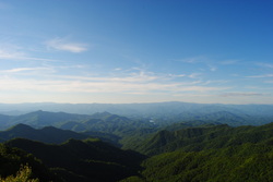
The Nantahala River is a premiere location for whitewater rafting and water slalom. The Nantahala Outdoor Center is situated right along the banks of the Nantahala's rushing waters, and on a good weekend, you can expect at least a hundred people here. Meanwhile, there's something for us hikers too. The Appalachian Trail passes through the NOC, crossing the busy US 74 and the Nantahala River. The Appalachian Trail offers a couple destinations in this area, including Cheoah Bald and Wesser Bald. While both are not easy to reach, both have ultimate rewarding views. This hike occurred on Friday, July 4th, 2014. My plan was to follow the Appalachian Trail from the NOC southward to the Jump-Up, and then even further to Wesser Bald and its fire tower. I would come back the same way. 

R/T Length of Trail: 13.5 Miles
Duration of Hike: 7 Hours, 40 Minutes
Difficulty Rating: 8 out of 10
Pros: Gradual ascent with few steep sections; very good winter views during the entire hike; fire tower; 360 degree views; outfitter store at trailhead
Cons: One extremely steep and rocky section, but short; lack of water; significant length of hike
Best Season(s) to Hike: Autumn; Winter
Trail Blaze Color(s): Appalachian Trail - White; Spur trails to shelters and water - Blue
Beginning Point: Large parking area at the Nantahala Outdoor Center
Directions: From Bryson City, NC: From the intersection of US Route 19 and US Route 74 near Bryson City, follow US Route 74 South for 9.4 miles until you see a road crossing a bridge to the right. Turn right onto the bridge, cross the railroad tracks, and park in the designated area. 
It's been a while since I last hiked more than 10 miles. Also, it's been a while since the last weekend with temperatures in the 70s and low humidity. Time for a long hike! I have been thinking to get to Wesser Bald for a while now, but all the time, something else came up that I liked more, and I would usually change my mind. However, this holiday weekend, I finally got together some more information about the hike, and decided to attempt it on July 4th. 


I love the drive down the Nantahala River. It's fun watching all the rafters with the river flowing along the road. I am not sure about what kind of other parking there is, but the place where I parked for the hike was in the Nantahala Outdoor Center parking lot. The most confusing thing about the entire hike is finding the trail. In most cases, the trail stats at the same place as where you park. Not in this case! It's more confusing than you think. In order to get onto the Appalachian Trail Southbound, you need to cross the bridge over the Nantahala River back onto US-74. Right away, cross US-74 and go onto Silvermine Road. After crossing a small creek on the road, watch for an Appalachian Trail sign on the left. Turn left onto the path here. The trail kicks off with a set of switchbacks up the steep mountainside. The switchbacks are accompanied by 5 small footbridges that help navigate muddy areas. After the last switchback, the trail leveled out and started following the edge of the mountain. During this time, the trail crossed two small streams that can be easily rock-hopped. There were also a couple rock cliffs. As the trail rounded the side of the mountain, the sounds of a tributary of Silvermine Creek were heard on the right. At 1 mile from the start, the trail reached the spur trail to the Rufus Morgan Shelter. The spur went to the left, while the AT continued forward past a majestic tree at the intersection. The real ascent started here. 


The trail ascended sets of steps as it followed the drainage of the Silvermine Creek tributary on the right. By the time it rounded the drainage, there was no water there. The trail continued its ascent via wooden steps. Here, I saw a black snake on the side of the trail. It was acting like it was dead. Shortly afterwards, the trail reached a gap and continued ascending. Over the course of the next 2 miles, there is nothing much to describe. The trail keeps following the hillside, crossing several ridges that climb up to the main one, as well as one small stream that appeared to be a tributary of Wesser Creek in the valley below. The trail kept getting rockier and rootier towards the 3-mile mark, and then, it suddenly popped out onto the main ridgeline. The trail reached a high point on the ridgeline, where there was a large rock. Then it went steeply downhill into a gap, before ascending again to follow the sometimes knife-edge ridgeline. However, the climbing was far from over, and the steepest was still ahead. There were several points where I could see Lowing Bald to the west. Also, around here was where the trail crossed from Swain County into Macon County. And then all of a sudden, you see the summit of the ridgeline looming right up front, and the steep part starts. The trail ascends through several rocky areas, including a place where minor scrambling is required. Following that, the trail climbed straight up with almost no switchbacks via numerous steps. Finally, the last push to the Jump-Up was another minor rock scramble to an incredible view.


To the north, I could see the Nantahala River Valley and Fontana Lake. On the horizon, I could see the Smokies. The panorama was great - and yet, this wasn't that close to the final viewpoint. I was now 4.3 miles from the trailhead. Another 2.4 miles to go. The trail shortly reached the high point of the ridge, before steeply dropping down into another gap. And yet, only to climb again. A couple switchbacks brought me to the crest of the knife-edge ridge, only to descend again shortly. The trail followed the ridge as it turned more to the southeast. There were several gaps and several hills in the course of the ridge. A final descent off the ridge brought me to the junction with the Wesser Creek Trail at 5.9 miles. If turning left onto the blue-blazed Wesser Creek Trail, it will bring you to the Wesser Creek Trailhead in 3.6 miles. This is certainly a shorter way to access Wesser Bald, but I decided to take the one I took so as to not miss out on the Jump-Up, and I am glad that I did. Also, the spur trail to the Wesser Bald Shelter went to the right. The final ascent to Wesser Bald started here. The rail ascended via long switchbacks. On one of the switchbacks, there was a spur trail to water, likely the headwaters of Wesser Creek. The ascent to Wesser Bald was perhaps one of the easiest parts of the hike. I was surprised. The switchbacks kept it almost unnoticeable. Finally as you reach a small gap, there is a view to the left, and a spur trail that goes forward. The AT goes to the right (downhill), but keep forward onto the spur trail. It shortly reaches the Wesser Bald summit 6.7 miles from the starting point. 


The Wesser Bald Fire Tower was erected in the mid 1900s, but in 1979, someone burned the cabin at the top of the fire tower. This was the reason that 2/3 of the tower was taken down. However, the stairway remained, and the empty space at the new top of the tower right above the treeline soon had an observation deck. The stairs led to this deck. There were only two flights of steps. But, at the top of the steps... what a view!!! The 360 degree panorama was as follows.
  • To the south was Copper Ridge Bald and Wayah Bald.
  • To the east was the Little Tennessee River Valley.
  • To the north was perhaps the grandest view. In the near sight was the Nantahala River Valley, followed by Fontana Lake and the Cheoah Mountains. On the background, the Smokies crowned the horizon. 
  • To the west was Nantahala Lake and the route of the Bartram Trail.

I could have, and did, stay for about a half-hour. On my way back at the Jump-Up, I managed to catch a brilliant sunset. Personally, I think it was the best one this year so far. 


Below are my pictures and a video from the hike. If you decide to do this hike, know that it's long, and know that there's other ways to reach it. You can cheat and come up from Wesser Creek or Tellico Gap, but the true sensation of accomplishment is when you do the hike like I did. The hike is not overly hard, and only on the lower end of challenging, because of its length. If you have been hiking in the area for a while, you can probably do it! I think this hike deserves to be classified as a "Best Hike". 
Best Hike!
13 Comments
Peggy Kurz
7/19/2015 03:03:13 am

Wow~ I really enjoyed your site and pics. Thanks for sharing. Camping for the season near Bryson near Happy Hollow. I hike to the waterfalls everyday, and would love to do just a piece of the AP I also have a chronic condition, but do about 4+miles a day. The views at Jump up are beautiful. How far is it from NOC to the Jump up and return? Thanks again for sharing. Peggy

Reply
Mark Oleg
7/29/2015 06:40:15 am

Hi Peggy,
Sorry for the delay in replying. I was in Florida for a month and did very limited operations on this site.
The distance from the NOC to the Jump-Up is 4.3 miles one way, or 8.6 miles roundtrip. You can expect it to be at least a moderately strenuous hike, with around 2200 feet of elevation gain.
Happy trails!
Mark

Reply
Nathan Garner
2/21/2017 07:26:13 am

I was doing some research and came across this older post. The Jump Up, according to every map I can find, is Northbound on the AT before Cheoah Bald, not Southbound.

Reply
Mark Oleg
2/21/2017 10:22:51 am

Hi Nathan,
I have seen references of the Jump-up being in both places, which confused me. Do you know the name of the rock outcrop with views on the southbound AT? Or is it unnamed?
Mark

Reply
Nathan Garner
2/21/2017 11:24:13 am

The map show that overlook as an unnamed scenic view. The one the map calls Jump Up is named as such because it succeeds a 7.5 mile climb northbound from the NOC. There is then a short descent and another 1.2 mile climb to Cheoah Bald. I did this section this weekend, and while the Bald was a great view, the rest of the trek to Fontana wasn't really anything to write about. Jacob's Ladder is a short but very tiring and steep climb, and the climb out of Cable Gap is deceptively tough, too. This whole stretch is considered the toughest in the Southern AT, possibly because of the length of the climb and possibly because of Jacob's Ladder, or a combination of the two.

Christina Cook Lee link
7/21/2017 11:54:46 am

Wondering if you would mind if I shared a link to this blog post on a website I'm doing for someone who has cabins in this area?

Reply
Jordan
7/30/2017 10:21:25 am

Great read! I do have a question about the parking. i'm trying to park there for a 5 day hike. what are your thoughts about parking there for 5 days. do you think i would be towed or should i ask to pay to park

Reply
Roy
9/20/2021 04:21:53 pm

Great article.i did the climb from nantahalla
to watch bald June 2021.going south to the bald was straight up.the views were worth it.

Reply
Edirne baymak servisi link
8/4/2022 06:07:59 am

Edirne baymak servisi için hemen websitemize göz at! https://www.edirneklimaservisi.com/edirne-baymak-servisi/

Reply
avcılar baymak yetkili servisi link
11/20/2022 07:07:42 am

Baymak yetkili servisi olarak hizmet vermekteyiz. Lütfen sitemizi ziyaret ediniz.

Reply
Baymak Yetkili Servisi link
12/12/2022 08:24:25 am

Baymak Yetkili Servisi Olarak Hizmet Vermekteyiz.

Reply
küçükçekmece kombi servisi link
9/28/2023 08:39:48 am

küçükçekmece kombi servisi olarak hizmet vermekteyiz.

Reply
Power Fence Company link
12/14/2023 04:34:00 am

interesting blog, thank you for sharing

Reply


Leave a Reply.

    About Me

    Mark Oleg Ozboyd
    I'm an avid outdoor explorer and a hobbyist landscape photographer. I'm 21 years old and have been hiking since 2011. Originally based out of Atlanta, Georgia, I started out by occasionally hiking short trails throughout well-known Georgia State Parks. During 2012 and 2013, I began to expand my trips into adjacent states, as well as into the wilder National Forest areas rather than just State Parks. Throughout the years that followed, as I slowly ran out of popular hiking trails in my area, I began to search for and hike in more seldom-visited areas. Today, you can find me out in the woods every weekend, whether it's on an official trail or bushwhacking through cross-country terrain without any paths. I now attend Washington & Lee University and am exploring Virginia and West Virginia. My other hobbies include chess, science, old music, and meteorology. I have 3 years of amateur weather forecasting experience, having studied a lot of meteorology basics over the years. I am also a student at European School of Music where I learned that music and nature have a lot in common. Listening to good music inspires me to capture nature's beauty on the camera in different aspects that also make me recall many beautiful music pieces that I've heard.​


    Dear readers: I have invested a tremendous amount of time and effort in this website and the Georgia Waterfalls Database the past five years. All of the work that has gone in keeping these websites updated with my latest trip reports has almost been like a full-time job. This has not allowed me to pick up a paid job to save up money for college, and therefore, I I've had to take out loans. If you find the information on this website interesting, helpful, or time-saving, you can say "thanks" and help me out by clicking the button above and making a contribution. I will be very grateful for any amount of support you give, as all of it will apply toward my college tuition. Thank you! 

    Enter your email address to subscribe for trail reports:

    Delivered by FeedBurner


    Picture
    Coming in 2022-2023?

    Other Hiking Websites

    DWHike's Adventures
    Florida's Natural Wonders
    Florida Trailblazer
    Meanderthals
    Mountain Images
    by Bernie Boyer

    North Carolina Waterfalls with
    ​Kevin Adams
    Take-a-Hike!
    Tennessee Landforms
    Waterfall Page
    Waterfall Adventurer
    Zach's Mild Adventures

    Miles Hiked

    Year 1: 540.0 Miles
    Year 2: 552.3 Miles
    ​Year 3: 518.4 Miles
    Year 4: 482.4 Miles
    Year 5: 259.9 Miles

    Archives

    March 2021
    February 2021
    January 2021
    November 2019
    October 2019
    September 2019
    August 2019
    July 2019
    June 2019
    February 2019
    January 2019
    December 2018
    November 2018
    October 2018
    August 2018
    July 2018
    June 2018
    May 2018
    April 2018
    March 2018
    February 2018
    January 2018
    December 2017
    November 2017
    October 2017
    September 2017
    August 2017
    July 2017
    June 2017
    May 2017
    April 2017
    March 2017
    February 2017
    January 2017
    December 2016
    November 2016
    October 2016
    September 2016
    August 2016
    June 2016
    May 2016
    April 2016
    March 2016
    January 2016
    December 2015
    November 2015
    October 2015
    September 2015
    August 2015
    July 2015
    June 2015
    May 2015
    April 2015
    March 2015
    February 2015
    January 2015
    December 2014
    November 2014
    October 2014
    September 2014
    August 2014
    July 2014
    June 2014
    May 2014
    April 2014
    March 2014
    February 2014

    Categories

    All
    Adel
    Adirondack Park
    Alabama
    Alfred A. Ring Park
    Allegheny Trail
    Amicalola Falls State Park
    Anniston Area
    Apalachicola Bluffs And Ravines Preserve
    Apalachicola National Forest
    Apalachicola/Port St. Joe Area
    Apopka
    Appalachian Trail
    Appling
    Art Loeb Trail
    Aska Trail System
    Bakersville
    Balm-Boyette Scrub Preserve
    Balsam Lake Recreation Area
    Bankhead National Forest
    Bartow County Parks
    Bartram Trail
    Basinger
    Beersheba Springs
    Benton
    Benton Mackaye Trail
    Berry College Trail System
    Best Hike
    Big South Fork National Recreation Area
    Black Bear Wilderness
    Black Rock Mountain State Park
    Blairsville
    Blakely
    Blood Mountain Wilderness
    Blowing Rock
    Blue Ridge
    Blue Ridge Parkway
    Boone
    Bradenton
    Bradenton Beach
    Brasstown Bald
    Brasstown Wilderness
    Brevard
    Bryson City
    Buchanan
    Bucks Pocket State Park
    Bulow Creek State Park
    Bulow Plantation Ruins State Park
    Caesars Head State Park
    Caladesi Island State Park
    Calhoun
    Camel's Hump State Park
    Cashiers
    Caspersen Beach Park
    Catfish Creek State Park
    Caves
    CC Putnam State Forest
    Cedar Point Environmental Park
    Chatsworth
    Chattahoochee National Forest
    Chattanooga
    Chattanooga Valley
    Chattooga National Wild And Scenic River
    Cheaha Wilderness
    Cherohala Skyway
    Cherokee
    Cherokee National Forest
    Chiefland Area
    Chillhowee Recreation Area
    Chipley
    Chunky Gal Trail
    Circle B Bar Reserve
    Citico Creek Wilderness
    Citrus Wildlife Management Area
    Clarkesville
    Clayton
    Cleevland
    Cleveland
    Cloudland Canyon State Park
    Cohutta Wilderness
    Collier-Seminole State Park
    Cordele
    Cornelia
    Covington
    Crestview Area
    Crew-land-and-water-trust
    Cullowhee
    Cumberland Trail
    Dahlonega
    Dalton
    Dawson Forest Wildlife Management Area
    Dawsonville
    Dayton
    De Soto National Memorial
    DeSoto State Park
    Dillard
    Double Springs
    Ducktown
    Duncan Ridge Trail
    Dunlap
    Eagle's Rest Park
    Eastpoint
    Econfina Creek Wildife Management Area
    Eglin Air Force Base
    Elizabethton
    Elkins
    Elk Knob Game Lands
    Elk Park
    Ellicott Rock Wilderness
    Ellijay
    Emerson Point Preserve
    Englewood Area
    Enota Retreat
    Erwin
    Falling Waters State Park
    Fayetteville
    Fires Creek Recreation Area
    Fire Tower
    Flint River
    Florence Area
    Florida
    Florida Caverns State Park
    Florida Trail
    Foothills Trail
    Fort Mountain State Park
    Fort Myers Area
    Fort Payne
    Fort Payne Area
    Fort Yargo State Park
    Franklin
    Franklin Delano Roosevelt State Park
    Franklin-Marion State Forest
    Frozen Head State Park
    Gainesville
    Gainesville Area
    Gatlinburg
    George Washington National Forest
    Georgia
    Georgia Veterans Memorial State Park
    Glasgow
    Gorges State Park
    Grandfather Mountain State Park
    Great Smoky Mountains National Park
    Greeneville
    Green River Game Lands
    Gruetli-Laager
    Grundy Forest State Natural Area
    GTM Reserve
    Guana River Wildlife Management Area
    Hayesville
    Helen
    Hiawassee
    High Falls State Park
    Highlands
    Highlands Scenic Highway
    Hillsborough River State Park
    Hinson Conservation & Recreation Area
    Historic Sites
    Honeymoon Island State Park
    Hot Springs
    Huntington
    Inverness Area
    Jackson
    Jasper
    Jefferson National Forest
    Joan M. Durante Park
    Jonathan Dickinson State Park
    Jones Gap State Park
    Joyce Kilmer Slickrock Wilderness
    Joyce Kilmer - Slickrock Wilderness
    Juniper Prairie Wilderness
    Kelly Park
    Keown Falls Recreation Area
    Kolomoki Mounds State Park
    LaFayette
    Lake City Area
    Lake George Wild Forest
    Lake June-in-Winter State Park
    Lakeland Area
    Lake Placid
    Lake Russell Wildlife Management Area
    Lake Wales Ridge State Forest
    Laurel Fork North Wilderness
    Leffis Key Preserve
    Leon Sinks Geological Area
    Lexington
    Lineville
    Linville
    Linville Gorge Wilderness
    Lithia Springs
    Little Frog Wilderness
    Little Manatee River State Park
    Little River Canyon National Preserve
    Longboat Key
    Long Trail
    Lookout Mountain
    Lookout Mountain Battlefield
    Lovingston
    Lula Lake Land Trust
    Lumpkin
    Maggie Valley
    Manatee Springs State Park
    Marianna Area
    Mark Trail Wilderness
    Marlinton
    Mccaysville
    McMinville
    Mentone
    Middlesex
    Mistletoe State Park
    Monongahela National Forest
    Montreat
    Mountain Bridge Wilderness Area
    Mountain City
    Mountains To Sea Trail
    Mountains-to-Sea Trail
    Mount Rogers National Recreation Area
    Myakka River State Park
    Myron B. Hodge City Park
    Nantahala National Forest
    Naples
    Naples Area
    Natural Bridge State Park
    Neal Preserve
    New Castle
    Newport
    New River Gorge National Park
    New York
    North Carolina
    Ocala Area
    Ocala National Forest
    Ocean-to-Lake Trail
    Oconee State Park
    Oconee Station Historic Site
    Okaloacoochee Slough State Forest
    Oldsmar
    Oneida
    Orlando Area
    Ormond Beach
    Oscar Scherer State Park
    Oxford
    Palatka
    Palmetto Trail
    Panama City Area
    Panthertown Valley
    Parrish
    Paynes Creek Historic State Park
    Peaks Of Otter Recreation Area
    Pigeon Crockford Mountain Wildlife Management Area
    Pigeon-Crockford Mountain Wildlife Management Area
    Pigeon-Crockford Wildlife Management Area
    Pine Mountain
    Pinhoti Trail
    Pinnacle Park
    Pisgah Civitan Park
    Pisgah National Forest
    Pittman Center
    Pond Mountain Wilderness
    Ponds/Lakes
    Prentice Cooper State Forest
    Providence Canyon State Park
    Pumpkintown
    Quick Point Nature Preserve
    Raven Cliffs Wilderness
    Reed Bingham State Park
    Reliance
    Rice Creek Conservation Area
    Riverview Pointe Preserve
    Robbinsville
    Robinson Preserve
    Rock Creek Gorge Scenic Area
    Rock Island State Park
    Rome
    Rosman
    Sale Creek
    Salem
    Salt Springs
    Saluda
    Santa Rosa Beach
    Sarasota
    Sarasota Area
    Savage Gulf State Natural Area
    Scenic Views
    Scottsboro Area
    Sebring Area
    Sewanee
    Sheltowee Trace Trail
    Shining Rock Wilderness
    Signal Mountain
    Sipsey Wilderness
    Sky Valley
    Smithgall Woods State Park
    Snowbird Backcountry Area
    Soddy Daisy
    Soddy-Daisy
    Sopchoppy
    South Carolina
    South Cumberland State Park
    Southeastern Cave Conservancy
    Southern Nantahala Wilderness
    Sparta
    Sprewell Bluff Park
    Spring City
    Spring Hill
    Springs
    Spruce Pine
    Standing Indian Backcountry Area
    St. Augustine
    St. George Island State Park
    St. Joseph Bay State Buffer Preserve
    St. Marks Area
    St. Marks National Wildlife Refuge
    Stone Mountain
    Stone Mountain Park
    Suches
    Sumatra
    Sumter National Forest
    Suwannee River
    Swallow Creek Wildlife Management Area
    Sweetwater Creek State Park
    Sylva
    Talladega National Forest
    Tallahassee Area
    Tallulah Falls
    Tallulah Gorge State Park
    Tampa Bay Area
    Tate City
    Tate's Hell State Forest
    Tea Creek Wildlife Management Area
    Tellico Plains
    Tennessee
    Thomaston
    Toccoa
    Topsail Hill State Park
    Torreya State Park
    Townsend
    Tracy City
    Tray Mountain Wilderness
    Trenton
    Triple Creek Preserve
    Troutdale
    Unaka Mountain Wilderness
    Upper Tampa Bay County Park
    Venice
    Vermont
    Virgin Falls State Natural Area
    Virginia
    Virginia Outdoors Foundation
    Vogel State Park
    Wakulla Springs State Park
    Waleska
    Walhalla
    Wartburg
    Water Features
    Waynesville
    Weedon Island Preserve
    Weeki Wachee Preserve
    Wekiwa Springs State Park
    West Palm Beach Area
    West Virginia
    Whitehall
    White Springs
    Winder
    Withlacoochee State Forest
    Young Harris

    RSS Feed

TRAIL REPORTS

Hikes in Alabama
​Hikes in Florida
Hikes in Georgia
Hikes in North Carolina
Hikes in South Carolina
Hikes in Tennessee
Hikes in Virginia

Hiking Resources

Alabama Resources
​
Florida Resources
Georgia Resources
North Carolina Resources
​South Carolina Resources
​
Tennessee Resources

Other

Contact
Map of Hikes
Alphabetical List of Hikes
Southeast Nature Society
© COPYRIGHT 2014-2024
​ALL RIGHTS RESERVED.
Important: I disclaim any responsibility for any damage or personal injury that may occur as a result of the activities and information found on this website. All outdoor activities, especially off-trail hiking, are done at your own risk. Never hike or head into that area that may be above your fitness or experience level.
  • Home
  • Trail Reports
    • Best Hikes
    • Hikes with Scenic Views
    • Hikes with Water Features
    • Alabama
    • Georgia
    • Florida
    • North Carolina
    • South Carolina
    • Tennessee
    • Vermont
    • Virginia
  • Map
  • Hike List
  • Testimonials
  • Resources
  • Contact Us
  • Southeast Nature Society
    • Our Team
  • Georgia Waterfalls Database