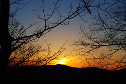
 When you hear about the Black Mountains of Western North Carolina, Mt. Mitchell and the Craggy Gardens usually come to mind. However, there is something else besides that most people don't know about, especially those who live farther away. Below Mt. Mitchell and its 6000' brethren is the Asheville watershed, and to the east of the watershed is a small private community called Montreat. And what most people don't know, besides the ones who live there, is that there are 20 miles of hiking trails in Montreat, and a lot of them are strenuous. This hike occurred on Saturday, March 8th, 2014. My plans were to take the Graybeard Trail from the trailhead in Montreat up to Graybeard Mountain Overlook and descend back to Montreat via the West Ridge Trail on Seven Sisters Ridge and then down Big Piney Ridge Trail. SummaryR/T Length of Trail: 9 Miles Duration of Hike: 7:00 Type of Hike: Loop Difficulty Rating: 7 out of 10 Pros: Relatively easy ascent on good trails; lots of winter views Cons: Very rough descent on West Ridge Trail Points of Interest: Graybeard Falls - 2 stars; Walker Knob - 7 stars; Graybeard Mountain - 8 stars; Rattlesnake Rock Vista - 5 stars Trail Blaze Color(s): Graybeard Trail - Blue; Walker's Knob Trail - Orange; West Ridge Trail - Gray; Big Piney Ridge Trail - Orange Best Season(s) to Hike: Year-round (there are good winter views from West Ridge/Seven Sisters Ridge) Fees: None Beginning Point: Graybeard Trailhead at the end of Graybeard Trl (the road) in Montreat Directions: From Asheville NC: Take I-40 East towards Black Mountain. Enter Exit 64 towards Black Mountain/Montreat State Route 9. Take a left at the traffic light, and drive 4.1 miles to the end of the road and the large parking lot. DetailsIt was a while, since I last visited the mountains in Northwestern North Carolina. 3 weeks passed. So why not? The day before there was a significant snowstorm in the higher elevations of North Carolina, and of course, the first place for hiking that came to mind was the Smoky Mountains. However, the roads were closed there because of winter weather, so I had to look for an alternative. I shortly found Montreat and its hiking trails, and by looking at a few other trail descriptions, realized that Graybeard Mountain looked very attractive. So I decided to give it a try. It was a long drive from Atlanta. About 4 hours. The road was beautiful, as it always is when going to those regions. When I passed through the center of Montreat and reached the end of the road, I was surprised how many cars there were at the trailhead. I barely found a parking spot. Of course, not everybody did the challenging climb up to Graybeard Mountain (there were other trails going from this parking lot too), but I think half of the people went up to the mountain. The trail started on the upper right hand corner of the parking lot. It immediately crossed Slaty Branch on a footbridge, and went right to the climb. Sorry, no warm-ups on this trail. You will quickly come to an intersection with the Harry Bryan Trail, which takes you back to the parking lot, making a small loop trail. turn right here and keep following the blue blazes of the Graybeard Trail. For the first 1.5 miles, you will follow Flat Creek, and cross it several times. There will be no other footbridges except the one in the very beginning, but fortunately, there are a lot of strategically-placed rocks to help cross the creek each time. There will be a couple plagues regarding the Boggs Memorial Wilderness along the way. After the third and last creek crossing, the trail starts climbing more steeply, and it keeps getting steeper, until you pop out onto a trail intersection at 1.5 miles from the start. Here, signage is plentiful. The Graybeard trail turns left into the first of a series of long switchbacks, while if you take a right, over the log to ford on the creek, you will be on the Old Trestle Road that goes southeast towards Long Gap, the Old Mitchell Toll Road, and the East Ridge trail. However, my plans were to keep following the Graybeard Trail. This section of the trail is flat and enjoyable, and works for a nice break from the previous climbing, and a warm-up for what was to come. You will soon come to an overlook, and your first view of the Swannanoa Mountains. After taking some pictures, I kept following this flast section of the trail, and the snow appeared too around this time. A lot was melting, so the trail was a mess. It was full blown mud. Don't expect this area to be muddy in normal conditions; I do not think the trail will be muddy anywhere during normal conditions. You will soon switchback back towards the creek, and at the third switchback from the start of them, you will reach another intersection at approximately 2 miles. If you take a right here, you will come to Graybeard Falls in about 200 feet. I decided to check out the spur. Apparently Graybeard Falls is never a strong waterfall, because even with all the snow melting today, it was not very strong. It was a typical slide waterfall. I still recommend you check it out on your way up to Graybeard Mountain. Once back from the spur, keep going forward following the blue blazes, and there will be a couple more switchbacks. Once you reach the creek for the final time, there will be yet another intersection. If you take the path over the creek, it will take you shortly to the Old Mitchell Toll Road, but there is not anything interesting over there, unless you want to go mountain biking. I skipped this spur, and went away from the creek, starting the harder climb again. Nothing was extremely steep, but still a normal climb for 4-5 miles is definitely tiring. At roughly 3 miles, you will reach Walker Knob Shelter. The Shelter was constructed in 1984, and is great for overnight camping, if you register in advance. Here, the Graybeard Trail took a right continuing the climb, while the short, orange-blazed, 0.2-mile, Walker Knob Spur Trail, took a left. I decided to check out Walker Knob, as I knew the trail leads to a beautiful overlook. The trail stays flat for a bit, and then there will be a short but somewhat steep climb to the summit of Walker's Knob. Almost immediately, the trail opened out and ended at a large rock outcropping, with fantastic views to the south and west. To the south I saw the town of Black Mountains, and behind it, the Swannanoa Mountains, including High Windy Mountain. Meanwhile, looking to the west, I could see Graybeard Mountain, which is the main destination of the trail, Seven Sisters Ridge, and Big Piney Ridge, all of which would be used as the descent back to Montreat. I wanted to stay more and take in the views, but there was still lots of climbing and hiking ahead. Once back on the Graybeard Trail, it kept going moderately steeply upwards, and there really were no good places to catch your breath. Finally, at 4.2 miles, I popped out at a weird fence, and a large amount of signage. This was the summit of Big Slaty Mountain, sometimes referred to as the False Graybeard Mountain. To the left, downhill, went the West Ridge Trail, which would be the return route. To the right, went the Graybeard Mountain Spur Trail, which is 0.3 miles long, and ascends to the very top of Graybeard Mountain and reaches its overlook. There was a sign here, which said, that to the west of the West Ridge Trail (to the right of you if you are going downhill) is the Asheville watershed. There was an old barbed wire fence along the boundary of the watershed, and signs saying "Posted". The main sign here also noted that the West Ridge Trail is rugged and remote, and that it is not recommended to be out on it without proper clothes, food, and shoes, and not to be on it in the dark. When hiking this trail later, I was not quite sure on how exaggerated this advice was, but it was to some extent. Finally, the sign said that it is 3.9 miles from this point to get back to Montreat via Big Piney Ridge, and 4.1 miles via Stomping Knob Trail. For now, I took the spur trail up Graybeard Mountain. After crossing Big Slaty,it actually went downhill a tad, before climbing about 200 feet steeply to the top of the mountain. There were some knee high snow drifts here, that did not melt, although most of the snow did melt. Once at the top of the mountain, the last 0.1 mile is flat crossing over the narrow ridge on Graybeard Mountain, arriving at the overlook. While there were some bushes slightly impeding the view, the overlook was even more spectacular than Walker Knob. From here, you could see the whole extent of the Black Mountains, including Mount Mitchell, and its brother peaks. I also saw the Blue Ridge Parkway making its way through the mountain landscape. The Parkway was closed though, because of the snow. After taking some pictures and taking in the views, it was time to head back. From here, it was all downhill... or so I thought? After getting back to the West Ridge Trail intersection, I took it downhill. I could immediately see it wasn't used that much as the Graybeard Trail, because of much less footprints in the snow. The trail quickly went downhill, and pretty steeply, before reaching the summit of Little Slaty Mountain. The West Ridge Trail was pretty rugged, passed over many rock outcrops, where there was some minor cautiousness needed. However, it was not all downhill, like I expected. There was lots of ups and downs, on a downhill trend, passing over each of the "sister mountains" on Seven Sisters Ridge. However, the Asheville Watershed Reservoir kept getting closer, so I knew I was getting farther down. At about 2.5 miles from the start of the West Ridge Trail, and just after crossing the fifth "sister", I reached the junction with the Big Piney Ridge Trail. The West Ridge Trail continued south towards Stomping Knob, but I took Big Piney Ridge Trail westwards. It started out very steeply downhill, although flattened out somewhat a little later. In about 0.5 miles from the junction, I reached Rattlesnake Rock. This was a large rock outcrop, with views of Black Mountain almost directly below. The view was similar to Walker Knob, except it's lower. And nope, no rattlesnakes here today. The descent picked up again, and there was a lot of switchbacks, as I went down pretty steeply, but before I knew it, I reached the junction with the Lower Piney Trail, and it was flat from here. The Lower Piney Trail went to the right, while I kept left. I crossed a small creek, and exited the Big Piney Trail onto Suwanee Drive. Shortly afterwards, I reached Graybeard Trail Road, and from here, it was another quarter mile back to the parking lot. Overall, this was a quite difficult hike, but also a very beautiful hike. The only thing is, I think it might have been better to hike the trail counter-clockwise, because even though the first 1.5 miles would be very steep, the trail up Seven Sisters Ridge would be much easier, because it would be up and down the sisters, not going straight up without any stops. And on the way back down Graybeard Trail, you would have been going down at a gentle place, and wouldn't have to watch your feet in most places. Either way, I highly recommend this trail, and depending on your physical condition, you definitely need to check it out. I think I can put this one into the category of "Best Hikes". I hope this trail description helped you. See my photos below! VariationsHike out and back to Graybeard Falls - 4 Miles Hike out and back to Walker's Knob - 6.4 Miles Hike out and back to Graybeard Mountain via Graybeard Trail - 9 Miles Bonus Stops If you still have the energy, hike to the Lookout, another vista on the east side of Montreat. Pictures
1 Comment
8/4/2022 06:17:47 am
Edirne baymak servisi en uygun fiyat ve en hızlı servis garantisi ile sizlerle. https://www.edirneklimaservisi.com/edirne-baymak-servisi/ Leave a Reply. |
About MeMark Oleg Ozboyd Dear readers: I have invested a tremendous amount of time and effort in this website and the Georgia Waterfalls Database the past five years. All of the work that has gone in keeping these websites updated with my latest trip reports has almost been like a full-time job. This has not allowed me to pick up a paid job to save up money for college, and therefore, I I've had to take out loans. If you find the information on this website interesting, helpful, or time-saving, you can say "thanks" and help me out by clicking the button above and making a contribution. I will be very grateful for any amount of support you give, as all of it will apply toward my college tuition. Thank you!

Coming in 2022-2023?
Other Hiking WebsitesMiles HikedYear 1: 540.0 Miles
Year 2: 552.3 Miles Year 3: 518.4 Miles Year 4: 482.4 Miles Year 5: 259.9 Miles Archives
March 2021
Categories
All
|
 RSS Feed