HIKING THE APPALACHIANS AND BEYOND
  • Home
  • Trail Reports
    • Best Hikes
    • Hikes with Scenic Views
    • Hikes with Water Features
    • Alabama
    • Georgia
    • Florida
    • North Carolina
    • South Carolina
    • Tennessee
    • Vermont
    • Virginia
  • Map
  • Hike List
  • Testimonials
  • Resources
  • Contact Us
  • Southeast Nature Society
    • Our Team
  • Georgia Waterfalls Database

Cumberland Trail: Signal Point to Edwards Point, Signal Mountain, Tennessee

4/7/2014

0 Comments

 
Picture
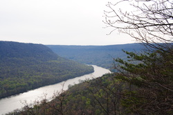
The Cumberland Trail is a state trail of Tennessee. It runs around 300 miles from its southern terminus at Signal Mountain, TN, to its northern terminus at Cumberland Gap, TN. It is not fully completed yet, but a lot of sections are open. It passes over the Cumberland Plateau of Tennessee, and is a very beautiful trail. I hope to hike many sections of it in the future. One of the most beautiful sections of it was the Tennessee River Gorge, my destination for this hike. This hike occurred on Saturday, April 5th, 2014. My plan was to hike the Cumberland Trail from its southern terminus at Signal Point Overlook to Edwards Point Overlook, and then return the same way.  

Summary

R/T Length of Trail: 5.6 Miles
Duration of Hike: 4:00
Type of Hike: Out and Back
Difficulty Rating: 5 out of 10
Pros: Great views on this excellent segment of the Cumberland Trail
Cons: Some sections of the hike are extremely rocky and slow
Points of Interest: Signal Point Overlook - 8 stars; Julia's Falls Overlook - 7 stars; Edwards Point Overlook - 10 stars
Trail Blaze Color(s): Cumberland Trail - White
Best Season(s) to Hike: Winter
Fees: None

Beginning Point: Signal Point Trailhead on the southwestern corner of the town of Signal Mountain. 
Directions: From Chattanooga, TN: Take US 27 North to the exit for Dayton Boulevard, Signal Mountain (US 127). Drive 4.8 miles on US 127 to Mississippi Avenue on Signal Mountain Turn left, and drive 1.1 miles to Signal Point Road. Turn left onto Signal Point  Road and drive 0.3 miles to the large parking lot. 

Details

My original plan was to hike a 12-mile loop hike in the Prentice Cooper State Forest, but it didn't take me long to find out that they closed the area because of a managed hunt. Thus, I changed my plans to hiking a section of the Cumberland Trail east of TN State Route 27. It was a beautiful section of trail from the southern terminus of the Cumberland Trail near Signal Mountain. The trail starts as a paved downhill path from the parking to the extensive overlook of Signal Point. The views were amazing, and I really liked it. This was just a taste of what was to come. There was a sign for "Cumberland Trail --->". The trail started off along a fence, and then went down some steps to a trailhead kiosk. I was returning in the dark, so I took a picture of the kiosk, with a camera flash, on my way back, and I included it in the photo gallery at the bottom of this post. After the kiosk, there was a pretty hard part of trail. First it went down several steep fights of steps, and then there were several switchbacks, with a steep descent, along the bluff of Signal Point. There did not seem to be any sane way to get this trail down the bluff. No matter how they would take it down, it would be a steep descent, and this was probably the best way to do it. At the last switchback, there was another flight of stairs, which was steeper than the others. There was a chance that you might lose balance here, so there is a cable along the left side of the stairs to help you come down. Once you are down this set of steps, there is a spur trail to the left that leads to another overlook. It is only 0.1 mile long, and it leads to a close-up view of the Tennessee River Valley Gorge. The views were breathtaking! 


Once back on the main trail, I think that you can say you have cleared the hardest section if the hike, with the exception of the climb back up the bluff on your return. The trail follows the base of the cliffs, and keeps going over rocks. At about 0.7 miles from the start of the hike, there will be an overlook to the front with an extensive view of the Middle Creek Valley, and another view of the Tennessee River Valley. I really liked this view even more than the other two overlooks. At this overlook, the trail turns right, and starts following the Middle Creek Valley. The trail will pass some apartments perched on the bluffs to the right. It will also cross several boulder fields. In a really large boulder field, there is a good view of Julia's Falls below. It is a waterfall on Middle Creek. It is easy to get lost in this boulder field too. There is a path going to the right, and it is not the trail, even though it will still come back to the main trail. However, it might be troublesome to get back on the main trail, because I accidentally got on that path, and there was a bunch of fallen trees and overgrowth. On my way back, I picked up the correct trail. The correct trail actually goes to the left, where there is a sign about the danger of high cliffs. The sign can be confusing, because it makes t look like you can't go there, but it actually means not to go off the trail. The trail passes through several more boulder fields, and at one point descends through a steep gap between stones. It will also cross a couple of small creeks. Roughly 0.3 miles from the Julia's Falls Overlook, the trail crosses a small, old suspension bridge over a creek. After the bridge, the trail descends pretty steely toward Middle Creek, and at 1.4 miles from the start of the hike, there will be a trail junction. Here, the Cumberland trail turns left over Middle Creek via a large suspension bridge. From here, it is 1.4 miles to Edward Point. Meanwhile, the Rainbow Lake Trail goes forward towards Rainbow Lake, and it is a way to access the town of Signal Mountain at the top. My goal was to go to Edwards Point, so I crossed the long suspension bridge, and here the trail started going steeply uphill. There will be another trail junction. The Bee Branch Trail goes to the right, also towards Rainbow Lake. It will reconnect with the Rainbow Lake trail. Meanwhile, the Cumberland Trail goes forward, and steeply ascends this side of the valley. After a little bit, it levels out, and there will be a rock formation called Lockhart Arch.


Lockhart Arch is a natural bridge, and the bluffs around it look impressive. There is also a campsite next to Lockhart Arch. After this, the trail doesn't' ascend much for a while, but keeps following the base of the cliffs. However, there will be a confusing section son, so I recommend paying attention to the blazes, which I myself didn't do. The trail turns right, and steeply climbs the bluffs, just before a small stream. I crossed the stream, and soon found that I was in the wrong place, so I came back to this spot, and then saw the trail climbing the bluffs. It is not hard to climb the bluff. There are some rocks, but at least no scrambling is needed. Once the trail reaches the top of the bluffs, it will be almost level for the rest of the time to Edwards Point. It shortly crosses a stream, and then a little later there will be an unmarked trail junction. Well, the Cumberland Trail and its white blazes go left, while to the right, the trail goes out onto an ATV trail. I kept following the Cumberland Trail, and crosses numerous small streams. At 2.4 miles from the start of the hike, and 1 mile from the large suspension bridge, the trail crossed a large, but unnamed stream, via rock hop.  The trail than ascended a hill, and leveled out for the last 0.1 miles. And there it was! Edwards Point overlook was located on a bend in the trail. The Cumberland Trail turned right, while the Overlook was straight ahead. The views were spectacular! I could see the Tennessee River entering the gorge, and Signal Point on the left side and Raccoon Mountain on the right side were like the entrance gate. I could see right where I came from, and it actually seemed more than 2.7 miles. After taking in the views, I went back on the trail the way I came, but because I thought it would take me less time to do this trail, I ended out hiking the last mile or so in the dark. I took the correct trail in the boulder field this time, and the ascent up Signal Point seemed easier than the descent, although I did find the cable on the stairs helpful. It was a good 4 hours since the start, when I finished the hike. An average 5.6 mile trail would take me 3 hours to hike, another evidence of how rocky the trail was. 
​

Update 11/25/17: I have learned that there are several more views past the first rock outcrop near Edwards Point, and each one is better than the first view I went to on my first hike on 4/5/14. Click here for an updated trail report with more accurate mileage and additional details.  

In summary, this trail was excellent. I can call it a "Best Hike". While it was slow and rocky, the views were spectacular, and I think I could safely say this is the most beautiful canyon I have been in yet. No matter how I liked my trip to Little River Canyon a short two weeks ago, this trip was even better, and I look forward to hiking more trails in this area in the near future. The photos from the trip are in the gallery below. 

Variations

Add the Bee Branch Trail and Rainbow Lake Loop to the hike.

Bonus Stops

The trail to a side view of Falling Water Falls is quite short and is located  to the northeast not far off nearby US Route 27.

Pictures

0 Comments


Leave a Reply.

    About Me

    Mark Oleg Ozboyd
    I'm an avid outdoor explorer and a hobbyist landscape photographer. I'm 21 years old and have been hiking since 2011. Originally based out of Atlanta, Georgia, I started out by occasionally hiking short trails throughout well-known Georgia State Parks. During 2012 and 2013, I began to expand my trips into adjacent states, as well as into the wilder National Forest areas rather than just State Parks. Throughout the years that followed, as I slowly ran out of popular hiking trails in my area, I began to search for and hike in more seldom-visited areas. Today, you can find me out in the woods every weekend, whether it's on an official trail or bushwhacking through cross-country terrain without any paths. I now attend Washington & Lee University and am exploring Virginia and West Virginia. My other hobbies include chess, science, old music, and meteorology. I have 3 years of amateur weather forecasting experience, having studied a lot of meteorology basics over the years. I am also a student at European School of Music where I learned that music and nature have a lot in common. Listening to good music inspires me to capture nature's beauty on the camera in different aspects that also make me recall many beautiful music pieces that I've heard.​


    Dear readers: I have invested a tremendous amount of time and effort in this website and the Georgia Waterfalls Database the past five years. All of the work that has gone in keeping these websites updated with my latest trip reports has almost been like a full-time job. This has not allowed me to pick up a paid job to save up money for college, and therefore, I I've had to take out loans. If you find the information on this website interesting, helpful, or time-saving, you can say "thanks" and help me out by clicking the button above and making a contribution. I will be very grateful for any amount of support you give, as all of it will apply toward my college tuition. Thank you! 

    Enter your email address to subscribe for trail reports:

    Delivered by FeedBurner


    Picture
    Coming in 2022-2023?

    Other Hiking Websites

    DWHike's Adventures
    Florida's Natural Wonders
    Florida Trailblazer
    Meanderthals
    Mountain Images
    by Bernie Boyer

    North Carolina Waterfalls with
    ​Kevin Adams
    Take-a-Hike!
    Tennessee Landforms
    Waterfall Page
    Waterfall Adventurer
    Zach's Mild Adventures

    Miles Hiked

    Year 1: 540.0 Miles
    Year 2: 552.3 Miles
    ​Year 3: 518.4 Miles
    Year 4: 482.4 Miles
    Year 5: 259.9 Miles

    Archives

    March 2021
    February 2021
    January 2021
    November 2019
    October 2019
    September 2019
    August 2019
    July 2019
    June 2019
    February 2019
    January 2019
    December 2018
    November 2018
    October 2018
    August 2018
    July 2018
    June 2018
    May 2018
    April 2018
    March 2018
    February 2018
    January 2018
    December 2017
    November 2017
    October 2017
    September 2017
    August 2017
    July 2017
    June 2017
    May 2017
    April 2017
    March 2017
    February 2017
    January 2017
    December 2016
    November 2016
    October 2016
    September 2016
    August 2016
    June 2016
    May 2016
    April 2016
    March 2016
    January 2016
    December 2015
    November 2015
    October 2015
    September 2015
    August 2015
    July 2015
    June 2015
    May 2015
    April 2015
    March 2015
    February 2015
    January 2015
    December 2014
    November 2014
    October 2014
    September 2014
    August 2014
    July 2014
    June 2014
    May 2014
    April 2014
    March 2014
    February 2014

    Categories

    All
    Adel
    Adirondack Park
    Alabama
    Alfred A. Ring Park
    Allegheny Trail
    Amicalola Falls State Park
    Anniston Area
    Apalachicola Bluffs And Ravines Preserve
    Apalachicola National Forest
    Apalachicola/Port St. Joe Area
    Apopka
    Appalachian Trail
    Appling
    Art Loeb Trail
    Aska Trail System
    Bakersville
    Balm-Boyette Scrub Preserve
    Balsam Lake Recreation Area
    Bankhead National Forest
    Bartow County Parks
    Bartram Trail
    Basinger
    Beersheba Springs
    Benton
    Benton Mackaye Trail
    Berry College Trail System
    Best Hike
    Big South Fork National Recreation Area
    Black Bear Wilderness
    Black Rock Mountain State Park
    Blairsville
    Blakely
    Blood Mountain Wilderness
    Blowing Rock
    Blue Ridge
    Blue Ridge Parkway
    Boone
    Bradenton
    Bradenton Beach
    Brasstown Bald
    Brasstown Wilderness
    Brevard
    Bryson City
    Buchanan
    Bucks Pocket State Park
    Bulow Creek State Park
    Bulow Plantation Ruins State Park
    Caesars Head State Park
    Caladesi Island State Park
    Calhoun
    Camel's Hump State Park
    Cashiers
    Caspersen Beach Park
    Catfish Creek State Park
    Caves
    CC Putnam State Forest
    Cedar Point Environmental Park
    Chatsworth
    Chattahoochee National Forest
    Chattanooga
    Chattanooga Valley
    Chattooga National Wild And Scenic River
    Cheaha Wilderness
    Cherohala Skyway
    Cherokee
    Cherokee National Forest
    Chiefland Area
    Chillhowee Recreation Area
    Chipley
    Chunky Gal Trail
    Circle B Bar Reserve
    Citico Creek Wilderness
    Citrus Wildlife Management Area
    Clarkesville
    Clayton
    Cleevland
    Cleveland
    Cloudland Canyon State Park
    Cohutta Wilderness
    Collier-Seminole State Park
    Cordele
    Cornelia
    Covington
    Crestview Area
    Crew-land-and-water-trust
    Cullowhee
    Cumberland Trail
    Dahlonega
    Dalton
    Dawson Forest Wildlife Management Area
    Dawsonville
    Dayton
    De Soto National Memorial
    DeSoto State Park
    Dillard
    Double Springs
    Ducktown
    Duncan Ridge Trail
    Dunlap
    Eagle's Rest Park
    Eastpoint
    Econfina Creek Wildife Management Area
    Eglin Air Force Base
    Elizabethton
    Elkins
    Elk Knob Game Lands
    Elk Park
    Ellicott Rock Wilderness
    Ellijay
    Emerson Point Preserve
    Englewood Area
    Enota Retreat
    Erwin
    Falling Waters State Park
    Fayetteville
    Fires Creek Recreation Area
    Fire Tower
    Flint River
    Florence Area
    Florida
    Florida Caverns State Park
    Florida Trail
    Foothills Trail
    Fort Mountain State Park
    Fort Myers Area
    Fort Payne
    Fort Payne Area
    Fort Yargo State Park
    Franklin
    Franklin Delano Roosevelt State Park
    Franklin-Marion State Forest
    Frozen Head State Park
    Gainesville
    Gainesville Area
    Gatlinburg
    George Washington National Forest
    Georgia
    Georgia Veterans Memorial State Park
    Glasgow
    Gorges State Park
    Grandfather Mountain State Park
    Great Smoky Mountains National Park
    Greeneville
    Green River Game Lands
    Gruetli-Laager
    Grundy Forest State Natural Area
    GTM Reserve
    Guana River Wildlife Management Area
    Hayesville
    Helen
    Hiawassee
    High Falls State Park
    Highlands
    Highlands Scenic Highway
    Hillsborough River State Park
    Hinson Conservation & Recreation Area
    Historic Sites
    Honeymoon Island State Park
    Hot Springs
    Huntington
    Inverness Area
    Jackson
    Jasper
    Jefferson National Forest
    Joan M. Durante Park
    Jonathan Dickinson State Park
    Jones Gap State Park
    Joyce Kilmer Slickrock Wilderness
    Joyce Kilmer - Slickrock Wilderness
    Juniper Prairie Wilderness
    Kelly Park
    Keown Falls Recreation Area
    Kolomoki Mounds State Park
    LaFayette
    Lake City Area
    Lake George Wild Forest
    Lake June-in-Winter State Park
    Lakeland Area
    Lake Placid
    Lake Russell Wildlife Management Area
    Lake Wales Ridge State Forest
    Laurel Fork North Wilderness
    Leffis Key Preserve
    Leon Sinks Geological Area
    Lexington
    Lineville
    Linville
    Linville Gorge Wilderness
    Lithia Springs
    Little Frog Wilderness
    Little Manatee River State Park
    Little River Canyon National Preserve
    Longboat Key
    Long Trail
    Lookout Mountain
    Lookout Mountain Battlefield
    Lovingston
    Lula Lake Land Trust
    Lumpkin
    Maggie Valley
    Manatee Springs State Park
    Marianna Area
    Mark Trail Wilderness
    Marlinton
    Mccaysville
    McMinville
    Mentone
    Middlesex
    Mistletoe State Park
    Monongahela National Forest
    Montreat
    Mountain Bridge Wilderness Area
    Mountain City
    Mountains To Sea Trail
    Mountains-to-Sea Trail
    Mount Rogers National Recreation Area
    Myakka River State Park
    Myron B. Hodge City Park
    Nantahala National Forest
    Naples
    Naples Area
    Natural Bridge State Park
    Neal Preserve
    New Castle
    Newport
    New River Gorge National Park
    New York
    North Carolina
    Ocala Area
    Ocala National Forest
    Ocean-to-Lake Trail
    Oconee State Park
    Oconee Station Historic Site
    Okaloacoochee Slough State Forest
    Oldsmar
    Oneida
    Orlando Area
    Ormond Beach
    Oscar Scherer State Park
    Oxford
    Palatka
    Palmetto Trail
    Panama City Area
    Panthertown Valley
    Parrish
    Paynes Creek Historic State Park
    Peaks Of Otter Recreation Area
    Pigeon Crockford Mountain Wildlife Management Area
    Pigeon-Crockford Mountain Wildlife Management Area
    Pigeon-Crockford Wildlife Management Area
    Pine Mountain
    Pinhoti Trail
    Pinnacle Park
    Pisgah Civitan Park
    Pisgah National Forest
    Pittman Center
    Pond Mountain Wilderness
    Ponds/Lakes
    Prentice Cooper State Forest
    Providence Canyon State Park
    Pumpkintown
    Quick Point Nature Preserve
    Raven Cliffs Wilderness
    Reed Bingham State Park
    Reliance
    Rice Creek Conservation Area
    Riverview Pointe Preserve
    Robbinsville
    Robinson Preserve
    Rock Creek Gorge Scenic Area
    Rock Island State Park
    Rome
    Rosman
    Sale Creek
    Salem
    Salt Springs
    Saluda
    Santa Rosa Beach
    Sarasota
    Sarasota Area
    Savage Gulf State Natural Area
    Scenic Views
    Scottsboro Area
    Sebring Area
    Sewanee
    Sheltowee Trace Trail
    Shining Rock Wilderness
    Signal Mountain
    Sipsey Wilderness
    Sky Valley
    Smithgall Woods State Park
    Snowbird Backcountry Area
    Soddy Daisy
    Soddy-Daisy
    Sopchoppy
    South Carolina
    South Cumberland State Park
    Southeastern Cave Conservancy
    Southern Nantahala Wilderness
    Sparta
    Sprewell Bluff Park
    Spring City
    Spring Hill
    Springs
    Spruce Pine
    Standing Indian Backcountry Area
    St. Augustine
    St. George Island State Park
    St. Joseph Bay State Buffer Preserve
    St. Marks Area
    St. Marks National Wildlife Refuge
    Stone Mountain
    Stone Mountain Park
    Suches
    Sumatra
    Sumter National Forest
    Suwannee River
    Swallow Creek Wildlife Management Area
    Sweetwater Creek State Park
    Sylva
    Talladega National Forest
    Tallahassee Area
    Tallulah Falls
    Tallulah Gorge State Park
    Tampa Bay Area
    Tate City
    Tate's Hell State Forest
    Tea Creek Wildlife Management Area
    Tellico Plains
    Tennessee
    Thomaston
    Toccoa
    Topsail Hill State Park
    Torreya State Park
    Townsend
    Tracy City
    Tray Mountain Wilderness
    Trenton
    Triple Creek Preserve
    Troutdale
    Unaka Mountain Wilderness
    Upper Tampa Bay County Park
    Venice
    Vermont
    Virgin Falls State Natural Area
    Virginia
    Virginia Outdoors Foundation
    Vogel State Park
    Wakulla Springs State Park
    Waleska
    Walhalla
    Wartburg
    Water Features
    Waynesville
    Weedon Island Preserve
    Weeki Wachee Preserve
    Wekiwa Springs State Park
    West Palm Beach Area
    West Virginia
    Whitehall
    White Springs
    Winder
    Withlacoochee State Forest
    Young Harris

    RSS Feed

TRAIL REPORTS

Hikes in Alabama
​Hikes in Florida
Hikes in Georgia
Hikes in North Carolina
Hikes in South Carolina
Hikes in Tennessee
Hikes in Virginia

Hiking Resources

Alabama Resources
​
Florida Resources
Georgia Resources
North Carolina Resources
​South Carolina Resources
​
Tennessee Resources

Other

Contact
Map of Hikes
Alphabetical List of Hikes
Southeast Nature Society
© COPYRIGHT 2014-2024
​ALL RIGHTS RESERVED.
Important: I disclaim any responsibility for any damage or personal injury that may occur as a result of the activities and information found on this website. All outdoor activities, especially off-trail hiking, are done at your own risk. Never hike or head into that area that may be above your fitness or experience level.
  • Home
  • Trail Reports
    • Best Hikes
    • Hikes with Scenic Views
    • Hikes with Water Features
    • Alabama
    • Georgia
    • Florida
    • North Carolina
    • South Carolina
    • Tennessee
    • Vermont
    • Virginia
  • Map
  • Hike List
  • Testimonials
  • Resources
  • Contact Us
  • Southeast Nature Society
    • Our Team
  • Georgia Waterfalls Database