HIKING THE APPALACHIANS AND BEYOND
  • Home
  • Trail Reports
    • Best Hikes
    • Hikes with Scenic Views
    • Hikes with Water Features
    • Alabama
    • Georgia
    • Florida
    • North Carolina
    • South Carolina
    • Tennessee
    • Vermont
    • Virginia
  • Map
  • Hike List
  • Testimonials
  • Resources
  • Contact Us
  • Southeast Nature Society
    • Our Team
  • Georgia Waterfalls Database

George Washington National Forest: Crabtree Falls Trail, Lovingston, Virginia

2/5/2017

0 Comments

 
Picture
Known as the tallest waterfall in Virginia, Crabtree Falls is a series of slides and waterfalls on Crabtree Creek, dropping approximately 1000 feet cumulatively. A hiking trail, equipped with well-constructed switchbacks and steps, provides easy access to all of the various drops of Crabtree Falls, each one unique in its own way. As a bonus, the large rock face at the top of the falls provides a great view into the Tye River Gorge. Just make sure to do this hike on a day when the crowds would likely be thinner than they were on my visit. This hike occurred on Sunday, November 27th, 2016. My plan was to hike the Crabtree Falls Trail out and back from VA 56 to the top of Crabtree Falls. ​This hike was the seventh and final of seven hikes that I did during a four-day Thanksgiving trip to the mountains of western Virginia.​

Summary

R/T Length of Trail: 3.2 Miles 
Duration of Hike: 3:15 (Please note that it took me a long time to hike this trail due to many photography stops. It can be hiked at a considerably faster pace) 
Type of Hike: Out and Back 
Difficulty Rating: 3 out of 10 
Total Elevation Gain: 1120 Feet 
Pros: Very well-built trail with no strenuous grades along the extremely steep Crabtree Creek
Cons: The Crabtree Falls Trail can be crowded; it is difficult to take good pictures of some of the portions of Crabtree Falls on a sunny day
Points of Interest: Crabtree Falls - 8 stars cumulatively (this includes all of the drops of Crabtree Falls); Top of Crabtree Falls Overlook - 4 stars
Trail Blaze Colors: Crabtree Falls Trail - Blue 
Best Seasons to Hike: Winter; Spring 
Fees: There is a $3 fee for parking at the VA 56 Crabtree Falls Trailhead.  
Beginning Point: Crabtree Falls Trailhead
Directions from Lovingston, VA: From the intersection of US Route 29 and US 29 Business on the south side of Lovingston, follow US 29 South for 4.3 miles, and then, turn right onto VA 56 West. Follow VA 56 for 4.9 miles, and then, turn right onto VA 151 North/VA 56 West. In another 2.5 miles, turn left to continue following VA 56. Follow VA 56 for 11.7 miles until the entrance to the Crabtree Falls parking area, which is located on the left side of the road. Drive up the short entrance road to the parking area, which consists of an upper lot and a lover overflow lot. 

Map

Click ​here for more information and to download this trail map to view in Garmin Basecamp.
Note: The Crabtree Falls Trail never crosses Crabtree Creek. My GPS bounced around a bit in the Crabtree Creek gorge, so the track shows some brief stretches on the east side of the creek. This is incorrect, as the trail always stays on the west side. 

Details

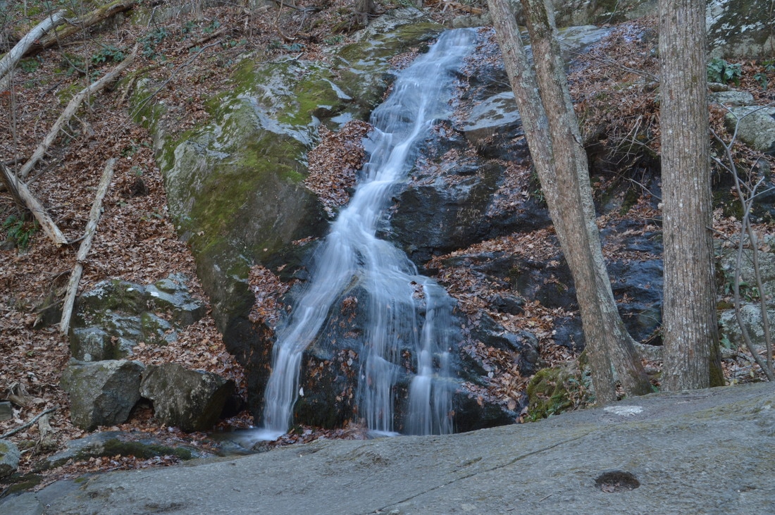
Crabtree Falls is widely known to be the tallest waterfall in Virginia. While it is true indeed, the waterfall is not actually one waterfall. Instead, Crabtree Falls actually consists of four main drops on Crabtree Creek, all of which cumulatively total slightly over 1000 feet. There is also a claim that the waterfall is the highest east of the Mississippi River, but that is pomewhat questionable, as there have been attempts to attribute this claim to other waterfalls (such as Amicalola Falls) as well. All four drops of the waterfall are beautiful, although it is located on a small creek, and it would be best to do this hike during winter or spring, when water levels are typically higher. When I did this hike in late November, water levels were slightly below normal even for fall's usually lower water levels, and as a result, many portions of Crabtree Falls were close to a trickle, but it was still beautiful. 

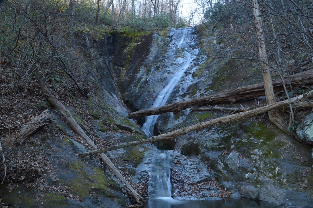
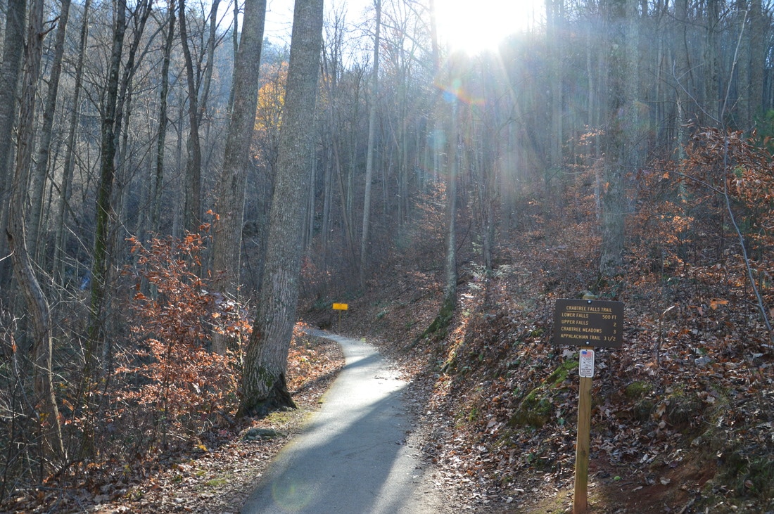
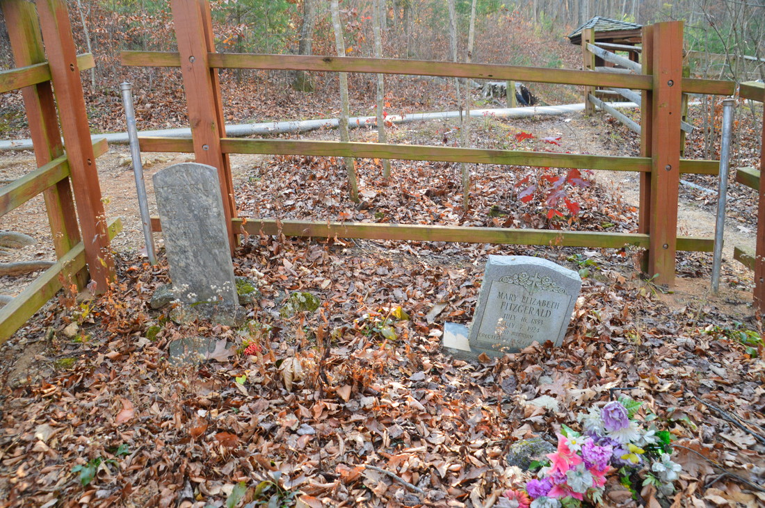
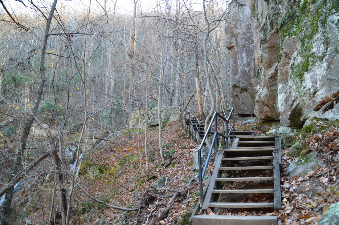
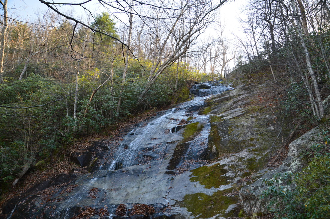
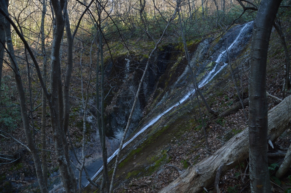
There are two approaches for Crabtree Falls: the "top" approach from Crabtree Meadows on FS 263, and the "bottom" approach from VA 56. The bottom approach is the common way to access Crabtree Falls, as the way back to the trailhead is all downhill. In fact, this was the approach I used on this day. The hike begins at either one of the two parking areas at Crabtree Falls Trailhead. Initially, the Crabtree Falls Trail follows a paved path. Near the beginning of the hike, a fenced off area to the left is home to two Fitzgerald graves. You will soon pass a mileage sign that indicates that the distance to the top of the falls is 2 miles, although my GPS device registered it as less than that. The paved path ends at an observation deck at the 1st (lowermost) drop of Crabtree Falls at 0.15 miles. This is the shortest of the four main drops, and it consists of a cascade that gradually falls down a sloping rock face. 

The main trail turns into a dirt path as it switchbacks acutely to the right. There are wooden posts with mile markers every tenth of a mile, and I found these mile markers to be more accurate than the sign at the beginning and much closer to my GPS readings. After another switchback, the trail returns to the creek and ascends a series of wooden staircases past some cascades on the creek, passing an observation deck. From a distance, you can see the entire 2nd drop of Crabtree Falls ahead, although as the trail gets closer to it, you can no longer see the full drop. At 0.35 miles, at a switchback, the trail reaches the base of the 2nd drop of Crabtree Falls. I consider this to be "Part 1 of the 2nd Drop", because you cannot see the full 2nd drop up close until farther up the trail. The entire 2nd drop consists of an impressive rock face, down which the creek steeply slides before ending with cascades. 
Picture
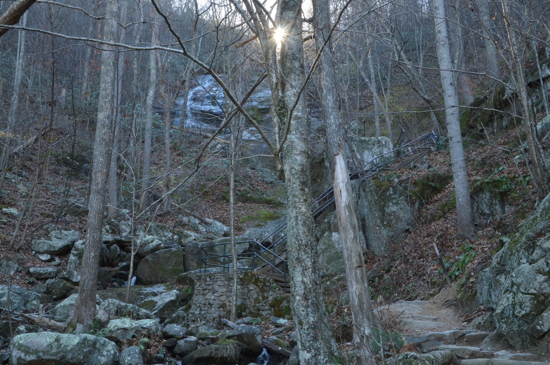
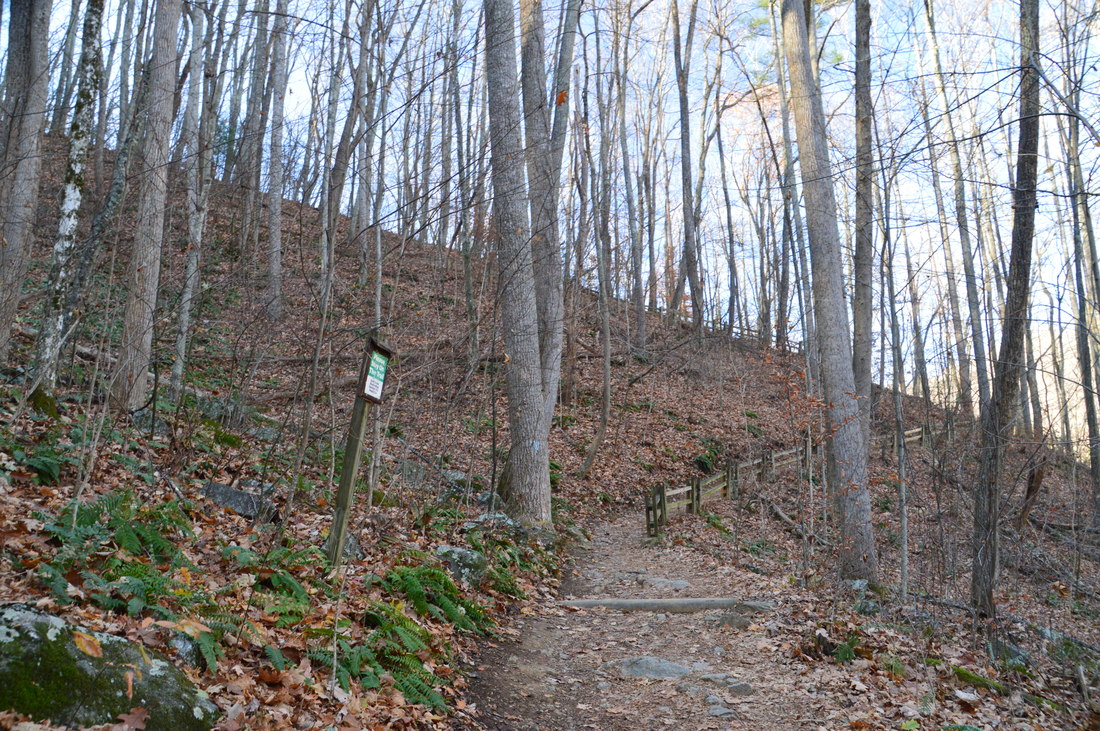
The Crabtree Falls Trail ascends several staircases along the steep Crabtree Creek as it works its way to each of the waterfall's main drops.
The trail leaves the creek for some time after the lower part of the 2nd drop, passing a somewhat limited view of the Tye River Gorge. After another switchback, the trail ascends several series' of wooden steps and reaches the upper part of the 2nd drop of Crabtree Falls at 0.6 miles. Here, there is a great view of the impressive rock slab that the creek flows down, although the creek was only a trickle as it spread into several different channels of water that flow down the rock slab. At 0.65 miles, the trail ascends a long wooden staircase near the top of the 2nd drop, before reaching an observation area at the top of the 2nd drop. From here, there are good views of the Tye River Gorge and of VA 56 down in the valley. From lower below, it seemed like the top of the 2nd drop was the top of Crabtree Falls, but once the trail reaches the top of this drop, it becomes evident that there is more falling water ahead. 

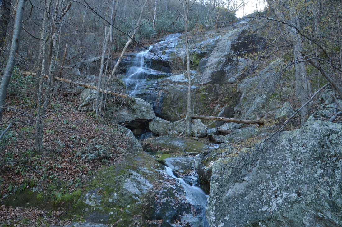
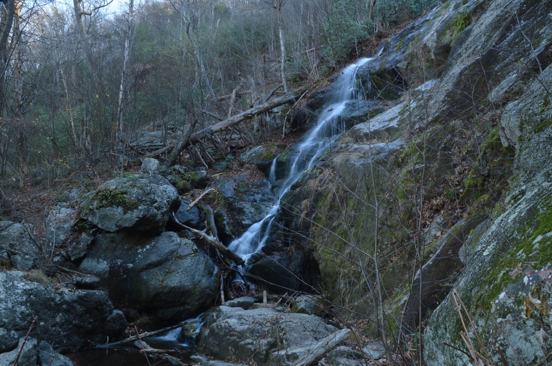
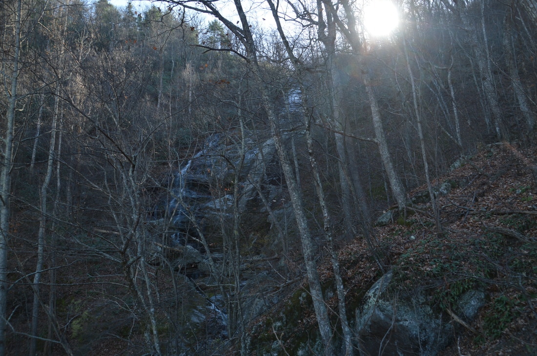
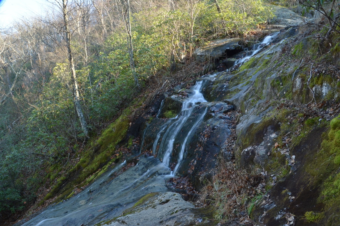
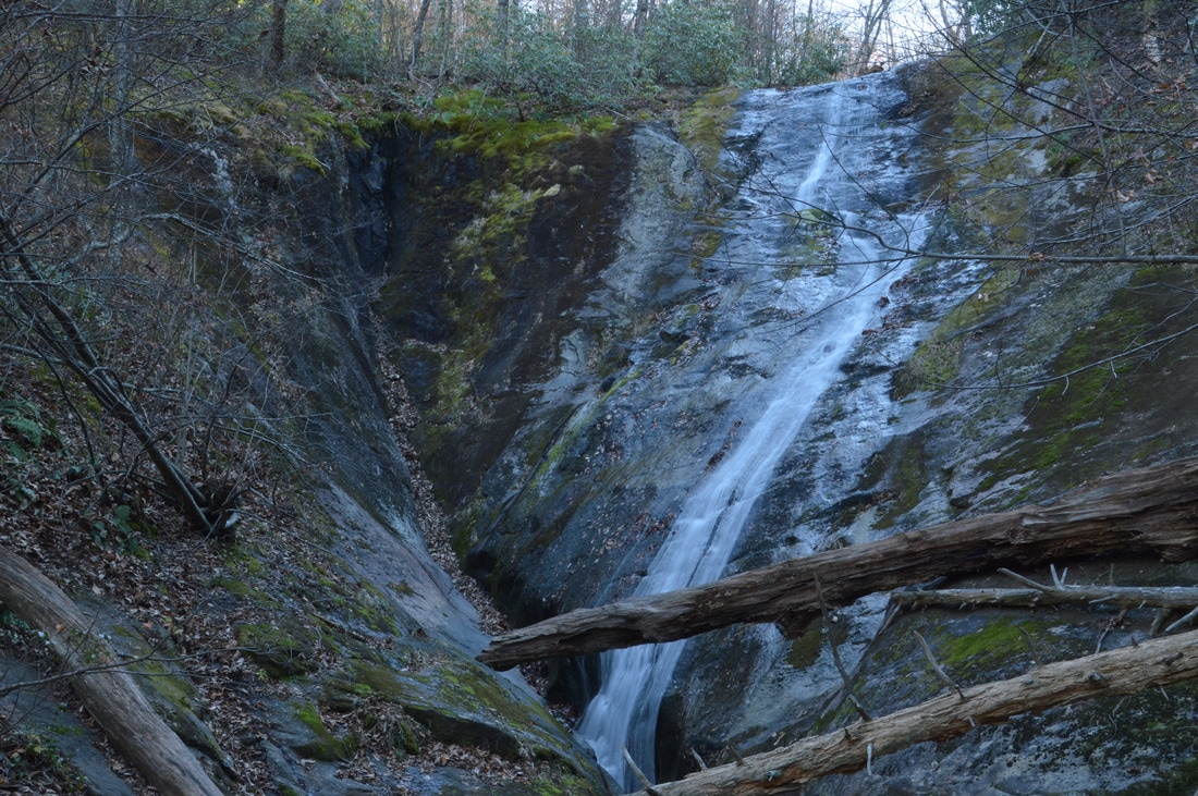
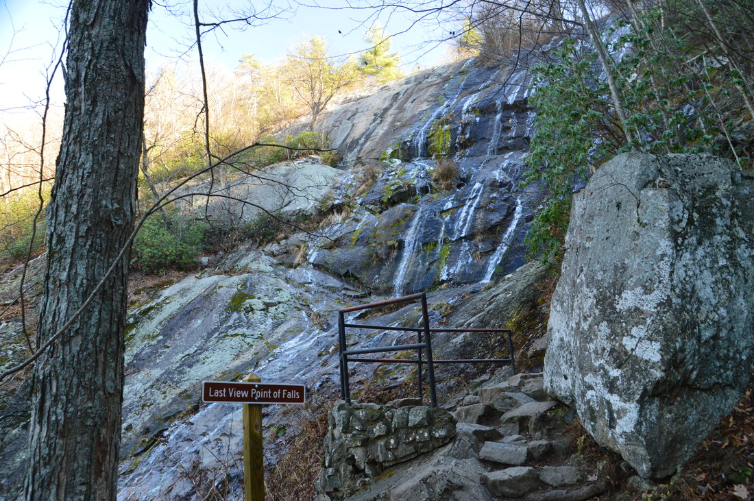
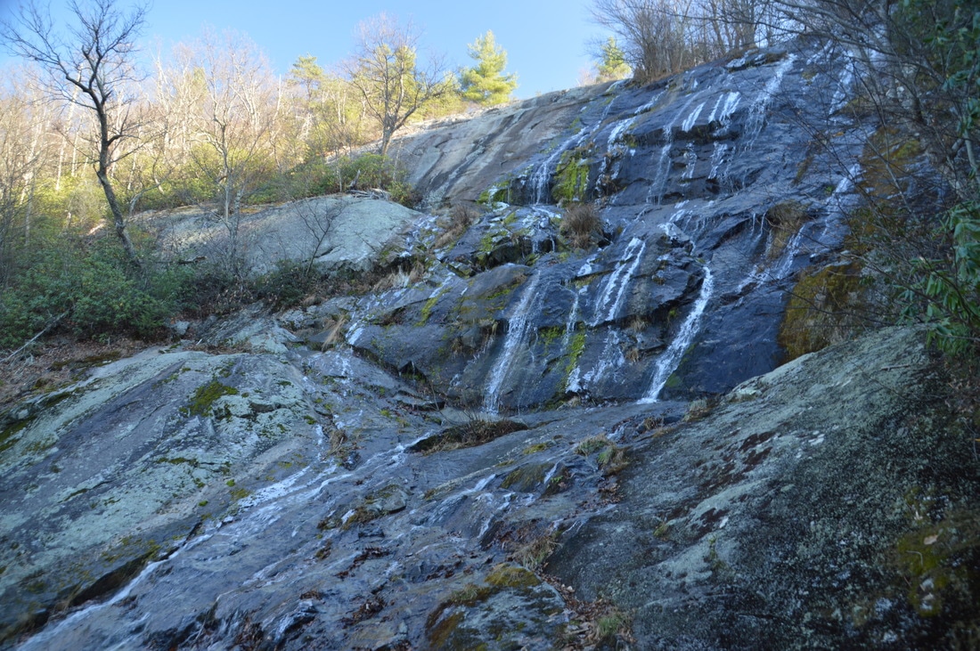
After the top of the 2nd drop, the trail gradually ascends along Crabtree Creek, which is flatter here with only small cascades. At 0.8 miles, the trail reaches the 3rd drop of Crabtree Falls, and a short side trail to the left leads to the base of the drop. In my opinion, this is the most scenic drop of Crabtree Falls. In fact, the 3rd drop of Crabtree Falls is the cover photo for this trail report. Here, there is a very scenic rock face with a depression in the middle. The creek actually slides down the right side of the rock face, while the depression is typically dry. However, the depression in the rock adds a very unique touch to this waterfall. Also, I like the view of this drop from the side, as it illustrates just how thin the ribbon of water is in relation to the rest of the rock face.

After the 3rd drop, the trail makes two pairs of switchbacks as it gradually works its way up the steep gorge and toward the uppermost (4th drop) of Crabtree Falls. At 1.3 miles, the trail reaches the 4th drop of Crabtree Falls. This is the top drop of the falls, and a sign states that this is the last viewpoint of the falls. This is  also the tallest drop of the falls, as the creek cascades down a very wide and tall rock face. During times of higher water, this can be an impressive waterfall, but on this day, the water flow was fairly low. 
Picture
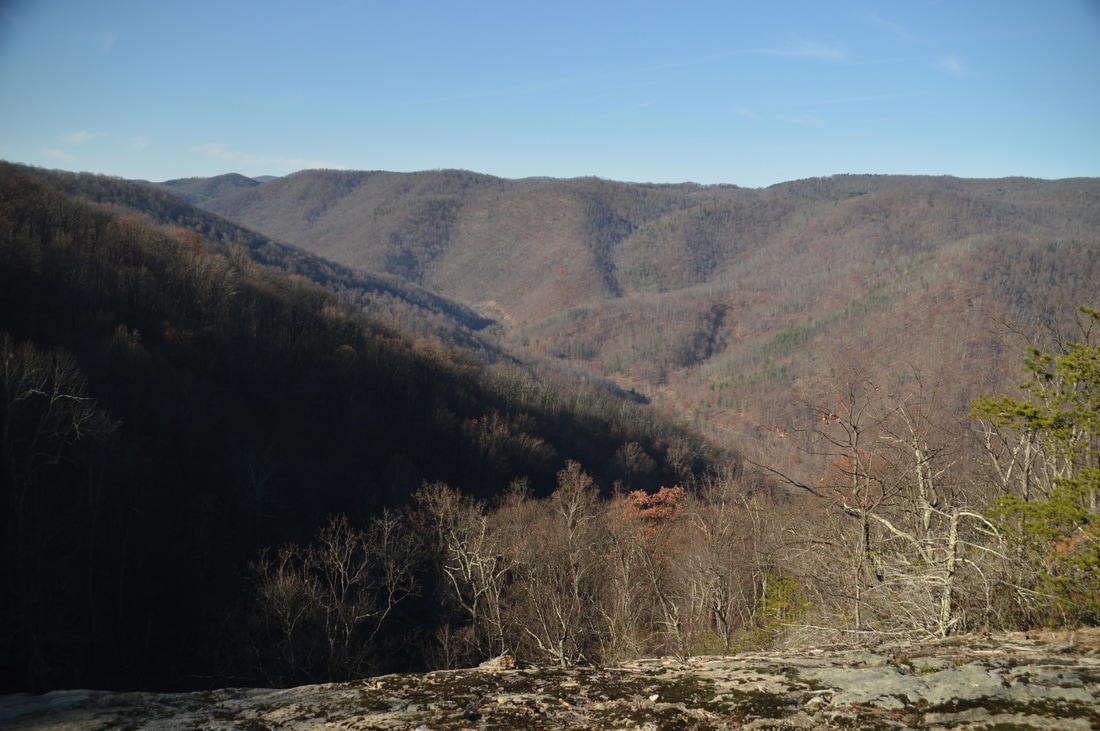
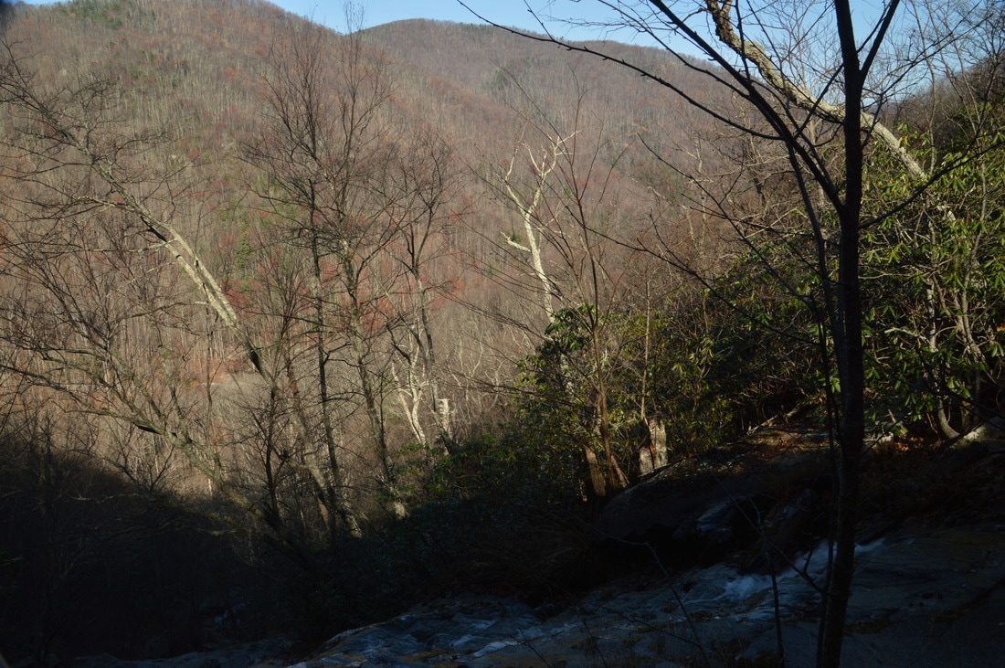
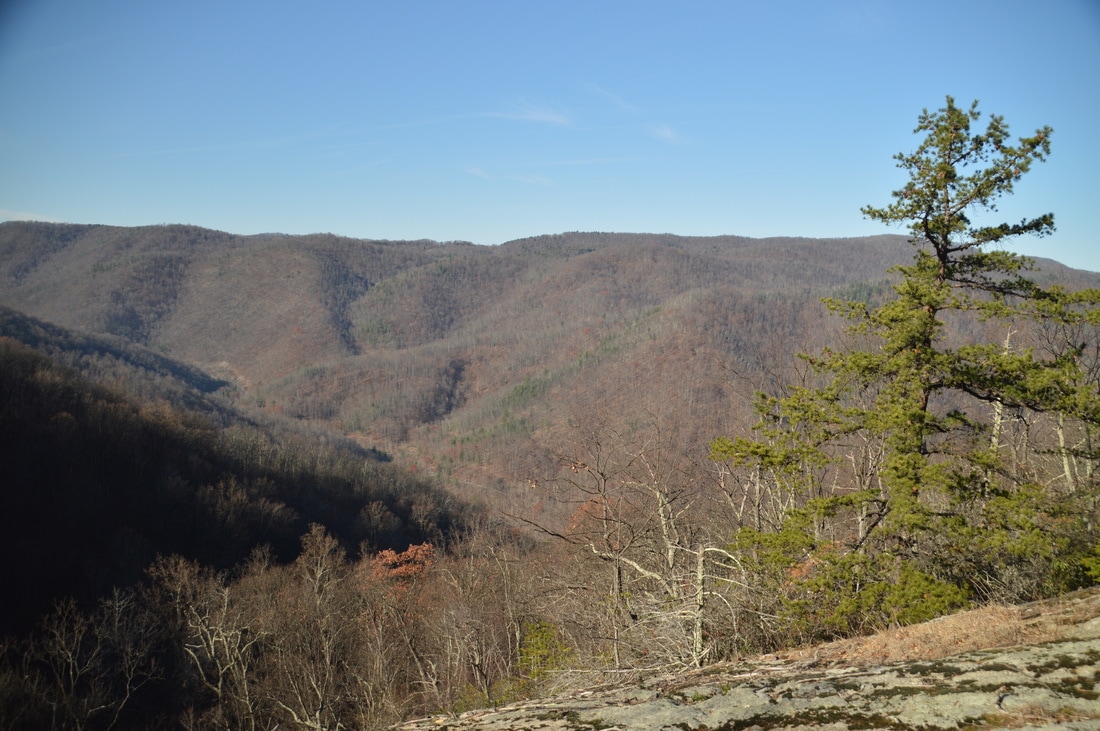
The view of the Tye River Gorge from the top of Crabtree Falls is a great bonus to the Crabtree Falls hike.
After passing the 4th drop of Crabtree Falls, the trail makes a final pair of switchbacks as it ascends to the top of Crabtree Falls. The trail reaches the top of Crabtree Falls at 1.6 miles (the mile marker here says that it is mile 1.7 - wonder what is more accurate?). Here, the Crabtree Falls Trail bears right along Crabtree Creek, eventually reaching Crabtree Meadows in a mile and the Appalachian Trail in a mile and a half. While this hike ends at the top of Crabtree Falls, there are multiple options for extending the hike to a variety of viewpoints on the Appalachian Trail. For this hike, at the top of the falls, bear left onto the short spur trail to the overlook of the Tye River Gorge. Cross Crabtree Creek via a footbridge and reach the overlook on the large rock slab on the other side. From here, there is a great view of the Tye River Gorge, with Fork Mountain and Aggies Mountain on the other side of the gorge. 

From the top of Crabtree Falls, simply retrace your steps along the Crabtree Falls Trail to the trailhead, reaching the trailhead and concluding the hike at 3.2 miles. 

Mileage

0.0 - Crabtree Falls Trailhead
0.15 - 1st Drop of Crabtree Falls 
0.35 - 2nd Drop of Crabtree Falls, Part 1 
0.6 - 2nd Drop of Crabtree Falls, Part 2 
0.8 - 3rd Drop of Crabtree Falls
1.3 - 4th Drop of Crabtree Falls 
1.6 - Top of Crabtree Falls Overlook 

Variations

Hike out and back to The Priest Mountain via Crabtree Falls Trail and Appalachian Trail - 8.0 Miles 
Hike out and back to Spy Rock via Crabtree Falls Trail and Appalachian Trail - 13.6 Miles

Bonus Stops

A short drive along the Blue Ridge Parkway northward leads to the trailhead for Humpback Rocks, which is a 2-mile hike to a fantastic view. There are also longer variations of it, including a 4-mile loop and an extension along the Appalachian Trail to more views. 

Pictures

Videos

0 Comments


Leave a Reply.

    About Me

    Mark Oleg Ozboyd
    I'm an avid outdoor explorer and a hobbyist landscape photographer. I'm 21 years old and have been hiking since 2011. Originally based out of Atlanta, Georgia, I started out by occasionally hiking short trails throughout well-known Georgia State Parks. During 2012 and 2013, I began to expand my trips into adjacent states, as well as into the wilder National Forest areas rather than just State Parks. Throughout the years that followed, as I slowly ran out of popular hiking trails in my area, I began to search for and hike in more seldom-visited areas. Today, you can find me out in the woods every weekend, whether it's on an official trail or bushwhacking through cross-country terrain without any paths. I now attend Washington & Lee University and am exploring Virginia and West Virginia. My other hobbies include chess, science, old music, and meteorology. I have 3 years of amateur weather forecasting experience, having studied a lot of meteorology basics over the years. I am also a student at European School of Music where I learned that music and nature have a lot in common. Listening to good music inspires me to capture nature's beauty on the camera in different aspects that also make me recall many beautiful music pieces that I've heard.​


    Dear readers: I have invested a tremendous amount of time and effort in this website and the Georgia Waterfalls Database the past five years. All of the work that has gone in keeping these websites updated with my latest trip reports has almost been like a full-time job. This has not allowed me to pick up a paid job to save up money for college, and therefore, I I've had to take out loans. If you find the information on this website interesting, helpful, or time-saving, you can say "thanks" and help me out by clicking the button above and making a contribution. I will be very grateful for any amount of support you give, as all of it will apply toward my college tuition. Thank you! 

    Enter your email address to subscribe for trail reports:

    Delivered by FeedBurner


    Picture
    Coming in 2022-2023?

    Other Hiking Websites

    DWHike's Adventures
    Florida's Natural Wonders
    Florida Trailblazer
    Meanderthals
    Mountain Images
    by Bernie Boyer

    North Carolina Waterfalls with
    ​Kevin Adams
    Take-a-Hike!
    Tennessee Landforms
    Waterfall Page
    Waterfall Adventurer
    Zach's Mild Adventures

    Miles Hiked

    Year 1: 540.0 Miles
    Year 2: 552.3 Miles
    ​Year 3: 518.4 Miles
    Year 4: 482.4 Miles
    Year 5: 259.9 Miles

    Archives

    March 2021
    February 2021
    January 2021
    November 2019
    October 2019
    September 2019
    August 2019
    July 2019
    June 2019
    February 2019
    January 2019
    December 2018
    November 2018
    October 2018
    August 2018
    July 2018
    June 2018
    May 2018
    April 2018
    March 2018
    February 2018
    January 2018
    December 2017
    November 2017
    October 2017
    September 2017
    August 2017
    July 2017
    June 2017
    May 2017
    April 2017
    March 2017
    February 2017
    January 2017
    December 2016
    November 2016
    October 2016
    September 2016
    August 2016
    June 2016
    May 2016
    April 2016
    March 2016
    January 2016
    December 2015
    November 2015
    October 2015
    September 2015
    August 2015
    July 2015
    June 2015
    May 2015
    April 2015
    March 2015
    February 2015
    January 2015
    December 2014
    November 2014
    October 2014
    September 2014
    August 2014
    July 2014
    June 2014
    May 2014
    April 2014
    March 2014
    February 2014

    Categories

    All
    Adel
    Adirondack Park
    Alabama
    Alfred A. Ring Park
    Allegheny Trail
    Amicalola Falls State Park
    Anniston Area
    Apalachicola Bluffs And Ravines Preserve
    Apalachicola National Forest
    Apalachicola/Port St. Joe Area
    Apopka
    Appalachian Trail
    Appling
    Art Loeb Trail
    Aska Trail System
    Bakersville
    Balm-Boyette Scrub Preserve
    Balsam Lake Recreation Area
    Bankhead National Forest
    Bartow County Parks
    Bartram Trail
    Basinger
    Beersheba Springs
    Benton
    Benton Mackaye Trail
    Berry College Trail System
    Best Hike
    Big South Fork National Recreation Area
    Black Bear Wilderness
    Black Rock Mountain State Park
    Blairsville
    Blakely
    Blood Mountain Wilderness
    Blowing Rock
    Blue Ridge
    Blue Ridge Parkway
    Boone
    Bradenton
    Bradenton Beach
    Brasstown Bald
    Brasstown Wilderness
    Brevard
    Bryson City
    Buchanan
    Bucks Pocket State Park
    Bulow Creek State Park
    Bulow Plantation Ruins State Park
    Caesars Head State Park
    Caladesi Island State Park
    Calhoun
    Camel's Hump State Park
    Cashiers
    Caspersen Beach Park
    Catfish Creek State Park
    Caves
    CC Putnam State Forest
    Cedar Point Environmental Park
    Chatsworth
    Chattahoochee National Forest
    Chattanooga
    Chattanooga Valley
    Chattooga National Wild And Scenic River
    Cheaha Wilderness
    Cherohala Skyway
    Cherokee
    Cherokee National Forest
    Chiefland Area
    Chillhowee Recreation Area
    Chipley
    Chunky Gal Trail
    Circle B Bar Reserve
    Citico Creek Wilderness
    Citrus Wildlife Management Area
    Clarkesville
    Clayton
    Cleevland
    Cleveland
    Cloudland Canyon State Park
    Cohutta Wilderness
    Collier-Seminole State Park
    Cordele
    Cornelia
    Covington
    Crestview Area
    Crew-land-and-water-trust
    Cullowhee
    Cumberland Trail
    Dahlonega
    Dalton
    Dawson Forest Wildlife Management Area
    Dawsonville
    Dayton
    De Soto National Memorial
    DeSoto State Park
    Dillard
    Double Springs
    Ducktown
    Duncan Ridge Trail
    Dunlap
    Eagle's Rest Park
    Eastpoint
    Econfina Creek Wildife Management Area
    Eglin Air Force Base
    Elizabethton
    Elkins
    Elk Knob Game Lands
    Elk Park
    Ellicott Rock Wilderness
    Ellijay
    Emerson Point Preserve
    Englewood Area
    Enota Retreat
    Erwin
    Falling Waters State Park
    Fayetteville
    Fires Creek Recreation Area
    Fire Tower
    Flint River
    Florence Area
    Florida
    Florida Caverns State Park
    Florida Trail
    Foothills Trail
    Fort Mountain State Park
    Fort Myers Area
    Fort Payne
    Fort Payne Area
    Fort Yargo State Park
    Franklin
    Franklin Delano Roosevelt State Park
    Franklin-Marion State Forest
    Frozen Head State Park
    Gainesville
    Gainesville Area
    Gatlinburg
    George Washington National Forest
    Georgia
    Georgia Veterans Memorial State Park
    Glasgow
    Gorges State Park
    Grandfather Mountain State Park
    Great Smoky Mountains National Park
    Greeneville
    Green River Game Lands
    Gruetli-Laager
    Grundy Forest State Natural Area
    GTM Reserve
    Guana River Wildlife Management Area
    Hayesville
    Helen
    Hiawassee
    High Falls State Park
    Highlands
    Highlands Scenic Highway
    Hillsborough River State Park
    Hinson Conservation & Recreation Area
    Historic Sites
    Honeymoon Island State Park
    Hot Springs
    Huntington
    Inverness Area
    Jackson
    Jasper
    Jefferson National Forest
    Joan M. Durante Park
    Jonathan Dickinson State Park
    Jones Gap State Park
    Joyce Kilmer Slickrock Wilderness
    Joyce Kilmer - Slickrock Wilderness
    Juniper Prairie Wilderness
    Kelly Park
    Keown Falls Recreation Area
    Kolomoki Mounds State Park
    LaFayette
    Lake City Area
    Lake George Wild Forest
    Lake June-in-Winter State Park
    Lakeland Area
    Lake Placid
    Lake Russell Wildlife Management Area
    Lake Wales Ridge State Forest
    Laurel Fork North Wilderness
    Leffis Key Preserve
    Leon Sinks Geological Area
    Lexington
    Lineville
    Linville
    Linville Gorge Wilderness
    Lithia Springs
    Little Frog Wilderness
    Little Manatee River State Park
    Little River Canyon National Preserve
    Longboat Key
    Long Trail
    Lookout Mountain
    Lookout Mountain Battlefield
    Lovingston
    Lula Lake Land Trust
    Lumpkin
    Maggie Valley
    Manatee Springs State Park
    Marianna Area
    Mark Trail Wilderness
    Marlinton
    Mccaysville
    McMinville
    Mentone
    Middlesex
    Mistletoe State Park
    Monongahela National Forest
    Montreat
    Mountain Bridge Wilderness Area
    Mountain City
    Mountains To Sea Trail
    Mountains-to-Sea Trail
    Mount Rogers National Recreation Area
    Myakka River State Park
    Myron B. Hodge City Park
    Nantahala National Forest
    Naples
    Naples Area
    Natural Bridge State Park
    Neal Preserve
    New Castle
    Newport
    New River Gorge National Park
    New York
    North Carolina
    Ocala Area
    Ocala National Forest
    Ocean-to-Lake Trail
    Oconee State Park
    Oconee Station Historic Site
    Okaloacoochee Slough State Forest
    Oldsmar
    Oneida
    Orlando Area
    Ormond Beach
    Oscar Scherer State Park
    Oxford
    Palatka
    Palmetto Trail
    Panama City Area
    Panthertown Valley
    Parrish
    Paynes Creek Historic State Park
    Peaks Of Otter Recreation Area
    Pigeon Crockford Mountain Wildlife Management Area
    Pigeon-Crockford Mountain Wildlife Management Area
    Pigeon-Crockford Wildlife Management Area
    Pine Mountain
    Pinhoti Trail
    Pinnacle Park
    Pisgah Civitan Park
    Pisgah National Forest
    Pittman Center
    Pond Mountain Wilderness
    Ponds/Lakes
    Prentice Cooper State Forest
    Providence Canyon State Park
    Pumpkintown
    Quick Point Nature Preserve
    Raven Cliffs Wilderness
    Reed Bingham State Park
    Reliance
    Rice Creek Conservation Area
    Riverview Pointe Preserve
    Robbinsville
    Robinson Preserve
    Rock Creek Gorge Scenic Area
    Rock Island State Park
    Rome
    Rosman
    Sale Creek
    Salem
    Salt Springs
    Saluda
    Santa Rosa Beach
    Sarasota
    Sarasota Area
    Savage Gulf State Natural Area
    Scenic Views
    Scottsboro Area
    Sebring Area
    Sewanee
    Sheltowee Trace Trail
    Shining Rock Wilderness
    Signal Mountain
    Sipsey Wilderness
    Sky Valley
    Smithgall Woods State Park
    Snowbird Backcountry Area
    Soddy Daisy
    Soddy-Daisy
    Sopchoppy
    South Carolina
    South Cumberland State Park
    Southeastern Cave Conservancy
    Southern Nantahala Wilderness
    Sparta
    Sprewell Bluff Park
    Spring City
    Spring Hill
    Springs
    Spruce Pine
    Standing Indian Backcountry Area
    St. Augustine
    St. George Island State Park
    St. Joseph Bay State Buffer Preserve
    St. Marks Area
    St. Marks National Wildlife Refuge
    Stone Mountain
    Stone Mountain Park
    Suches
    Sumatra
    Sumter National Forest
    Suwannee River
    Swallow Creek Wildlife Management Area
    Sweetwater Creek State Park
    Sylva
    Talladega National Forest
    Tallahassee Area
    Tallulah Falls
    Tallulah Gorge State Park
    Tampa Bay Area
    Tate City
    Tate's Hell State Forest
    Tea Creek Wildlife Management Area
    Tellico Plains
    Tennessee
    Thomaston
    Toccoa
    Topsail Hill State Park
    Torreya State Park
    Townsend
    Tracy City
    Tray Mountain Wilderness
    Trenton
    Triple Creek Preserve
    Troutdale
    Unaka Mountain Wilderness
    Upper Tampa Bay County Park
    Venice
    Vermont
    Virgin Falls State Natural Area
    Virginia
    Virginia Outdoors Foundation
    Vogel State Park
    Wakulla Springs State Park
    Waleska
    Walhalla
    Wartburg
    Water Features
    Waynesville
    Weedon Island Preserve
    Weeki Wachee Preserve
    Wekiwa Springs State Park
    West Palm Beach Area
    West Virginia
    Whitehall
    White Springs
    Winder
    Withlacoochee State Forest
    Young Harris

    RSS Feed

TRAIL REPORTS

Hikes in Alabama
​Hikes in Florida
Hikes in Georgia
Hikes in North Carolina
Hikes in South Carolina
Hikes in Tennessee
Hikes in Virginia

Hiking Resources

Alabama Resources
​
Florida Resources
Georgia Resources
North Carolina Resources
​South Carolina Resources
​
Tennessee Resources

Other

Contact
Map of Hikes
Alphabetical List of Hikes
Southeast Nature Society
© COPYRIGHT 2014-2018
​ALL RIGHTS RESERVED.
Important: I disclaim any responsibility for any damage or personal injury that may occur as a result of the activities and information found on this website. All outdoor activities, especially off-trail hiking, are done at your own risk. Never hike or head into that area that may be above your fitness or experience level.
  • Home
  • Trail Reports
    • Best Hikes
    • Hikes with Scenic Views
    • Hikes with Water Features
    • Alabama
    • Georgia
    • Florida
    • North Carolina
    • South Carolina
    • Tennessee
    • Vermont
    • Virginia
  • Map
  • Hike List
  • Testimonials
  • Resources
  • Contact Us
  • Southeast Nature Society
    • Our Team
  • Georgia Waterfalls Database