HIKING THE APPALACHIANS AND BEYOND
  • Home
  • Trail Reports
    • Best Hikes
    • Hikes with Scenic Views
    • Hikes with Water Features
    • Alabama
    • Georgia
    • Florida
    • North Carolina
    • South Carolina
    • Tennessee
    • Vermont
    • Virginia
  • Map
  • Hike List
  • Testimonials
  • Resources
  • Contact Us
  • Southeast Nature Society
    • Our Team
  • Georgia Waterfalls Database

Jefferson National Forest: Roaring Run Falls Loop, Covington, Virginia

2/3/2017

0 Comments

 
Picture
The Roaring Run gorge in Virginia's Blue Ridge sports numerous scenic slides and cascades, on top of a spectacular 35-foot Roaring Run Falls. Several short nature trails provide easy access to this pristine location. The area also has an interesting iron ore mining history, which can be observed today in the form of the Roaring Run Furnace, an iconic sight  along this short loop hike in the vicinity of Roaring Run. This hike occurred on Saturday, November 26th, 2016. My plan was to hike the Roaring Run Falls Loop clockwise, by first following the Streamside Trail and then returning along the Woodland Trail, after hiking the side trail to Roaring Run Falls. This hike was the sixth of seven hikes that I did during a four-day Thanksgiving trip to the mountains of western Virginia.​

Summary

R/T Length of Trail: 1.6 Miles 
Duration of Hike: 1:30 
Type of Hike: Loop 
Difficulty Rating: 2 out of 10 
Total Elevation Gain: 411 Feet 
Pros: Easy trail to several beautiful water features 
​Cons: The gorge view on the Woodland Trail is more limited than one would have desired 
Points of Interest: 35-Foot Slide on Roaring Run - 5 stars; Roaring Run Falls - 10 stars; Other cascades and slides on Roaring Run; Roaring Run Furnace 
Trail Blaze Colors: None 
Best Seasons to Hike: Spring 
Fees: None 
Beginning Point: Roaring Run Day Use Area
Directions from Covington, VA: From the intersection of US Route 60/220 (Allegheny Avenue) and VA Route 18 (Carpenter Drive), follow VA 18 South for 1.9 miles. Then, turn left onto VA 657 (Pitzer Ridge Road). In another 1.9 miles, turn left onto VA 619 (Hayes Gap Road). Follow VA 619 for 3.3 miles, before turning left onto VA 616 (Rich Patch Road). In 7.1 miles, turn right onto the entrance road to the Roaring Run Day Use Area, and reach the trailhead parking area in 0.2 miles.

Map

Click the link below to download a .KML file with a track of this hike.
jefferson_national_forest_roaring_run_falls_loop.kml
File Size: 27 kb
File Type: kml
Download File

Details

Roaring Run Falls was a hike that had been low on my list during my trip to Virginia. In fact, I had debated skipping it altogether, but I eventually found time to fit it in one evening. I have to admit that I had not expected anything as beautiful as this picturesque little gorge. The Streamside Trail to Roaring Run Falls passes several beautiful slides and cascades, including one of notable height (35 feet), before reaching the main show: a top-notch high-flow waterfall that spills over a ledge in the form of an upside-down "V". I highly recommend this short outing, if you ever find yourself in this area of Virginia.  

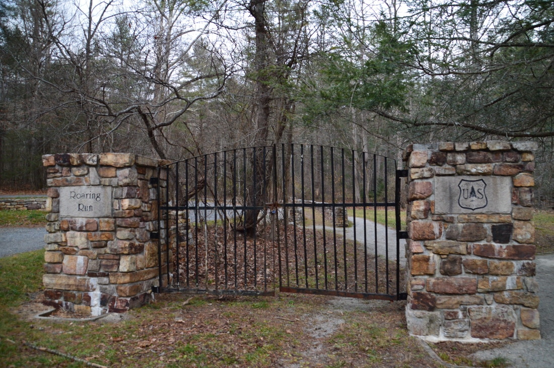
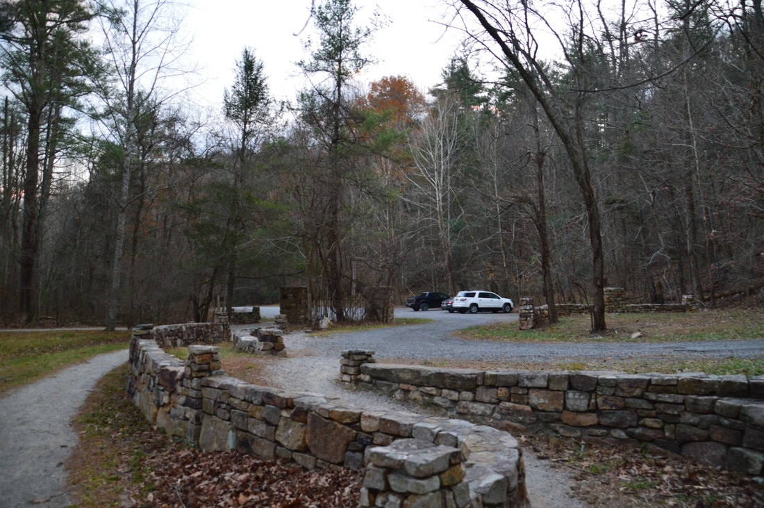
The hike begins at a historic gate at the large parking area. This iron gate, bordered by two stone pillars (one with a USFS logo and the other with the words "Roaring Run" inscribed), appears to be here for exhibit purposes, as the trail begins to the right of the gate. An "Iron Furnace & Trails" sign directs you in the right direction along a gravel path, leaving the picnic area to the right. Only about 250 feet from the trailhead, reach a major intersection at an information kiosk and restrooms. Here, thee trails head in different directions. To the left, the 2.4-mile Iron Ore Trail leads to the Hoop Hole Loop, which is a figure-8 loop that is actually designated as a National Recreation Trail and is around 9 miles long. Straight ahead, the Streamside Trail leads along Roaring Run to Roaring Run Falls. To the right, the Woodland Trail leads to the Roaring Run Furnace and then stays above the gorge on its alternative way to Roaring Run Falls. I hiked the Streamside Trail/Woodland Trail loop clockwise, passing through the scenic area first. For this short hike, you will not use the Iron Ore Trail, although it is certainly an option for extending the hike. To hike the loop the way I did, continue straight on the Streamside Trail. 
Picture
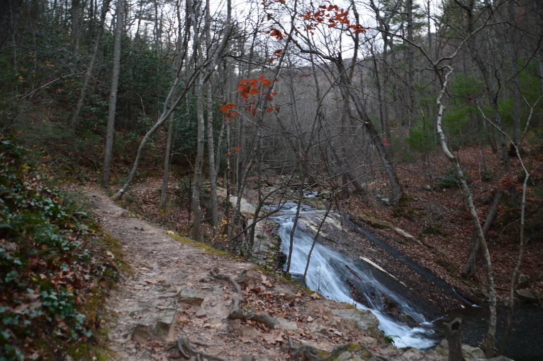
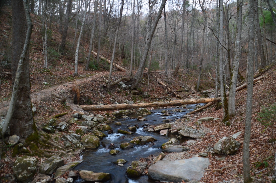
The Streamside Trail to Roaring Run Falls passes several beautiful slides and cascades on Roaring Run.
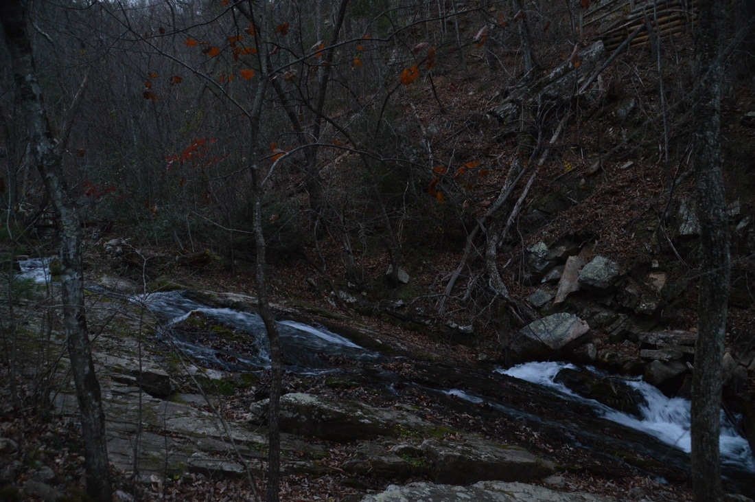
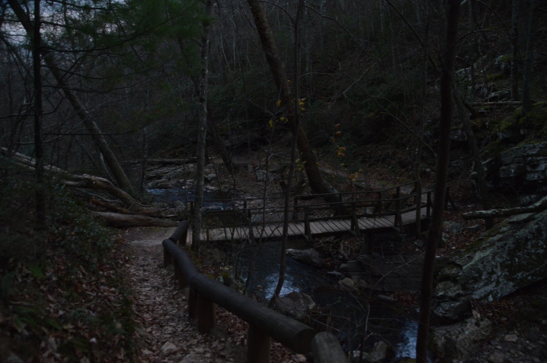
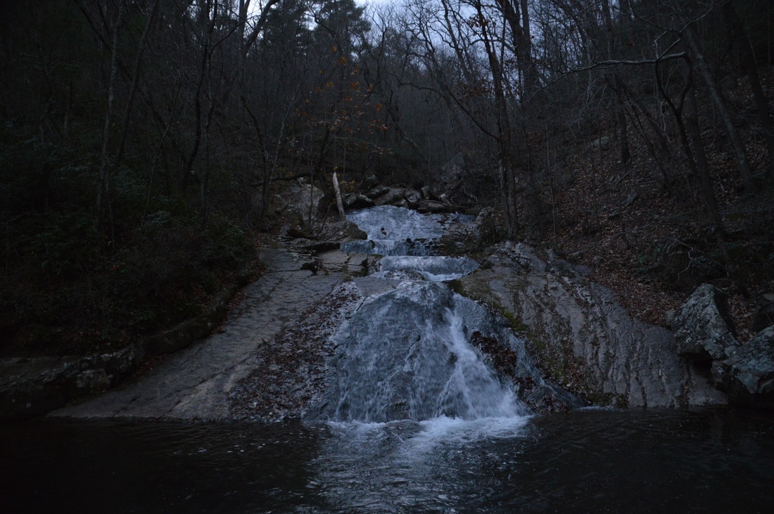
The Streamside Trail shortly comes alongside Roaring Run, which is a typical cascading mountain stream. At 0.2 miles, the trail crosses Roaring Run via a footbridge - just below a notable side - only to cross back to the west side of the creek a few dozen feet later. At about 0.35 miles, the trail passes by a taller slide to the right that is quite picturesque, especially during times of higher water. The gorge then narrows and the creek becomes faster, as the trail follows it along a boardwalk before crossing it for the third time at 0.5 miles, via another well-constructed wooden footbridge. On the other side of the creek is a junction with the Woodland Trail, which turns right and loops back to the trailhead. For now, turn left onto the spur trail to Roaring Run Falls. Just ahead is a multi-tiered slide on the creek that has a height of about 35 feet. In my opinion, this is a worthwhile waterfall in its own, although the main show definitely lies ahead. 

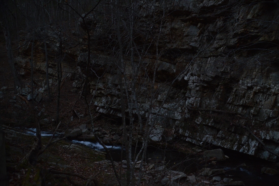
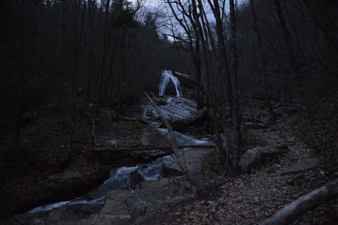
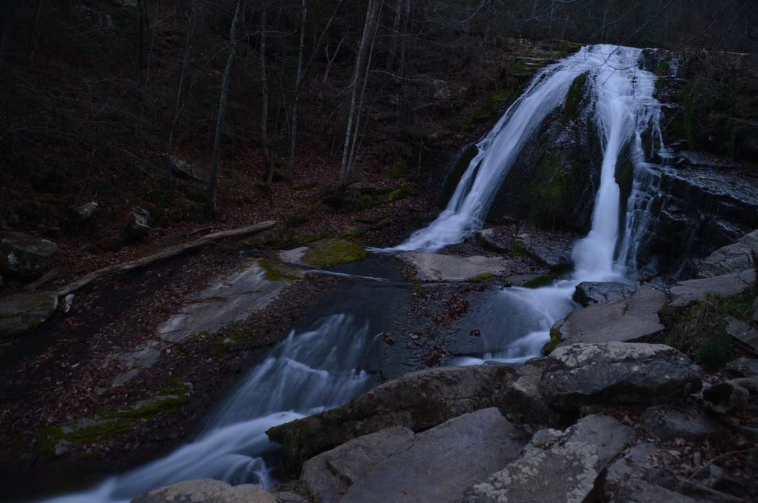
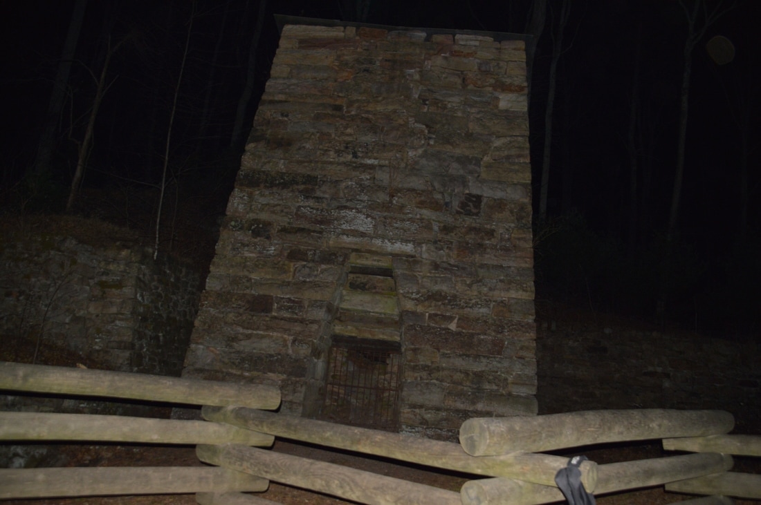
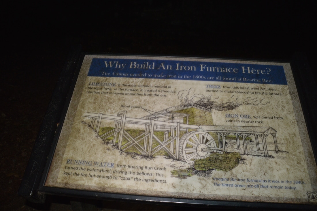
After ascending some rock steps and traversing increasingly rocky terrain, the trail dead-ends at Roaring Run Falls at 0.65 miles. This waterfall is a sight to behold. The creek spills down a 35-foot rock ledge, and the water fans out into two different channels down the ledge (that start at one point). The shape of the waterfall is like an upside-down letter V. Below the falls, the scenic creek tumbles over a few fast shoals before bending out of sight. A large slanted rock slab covers the area to the right and above the falls. This is one of the most photogenic waterfalls that I have seen, despite the relatively low height. 

From Roaring Run Falls, retrace your steps to the junction with the Woodland Trail. Continue straight onto it. The trail quickly ascends out of the gorge and leaves the creek. This is the the biggest uphill on the hike, but it really isn't much. The travel levels out around 1.0 miles, staying below VA 616. There are some winter views of the gorge to the right. The trail reaches a stone observation area at 1.05 miles, where there is a limited view into the Roaring Run Gorge. After this, a gradual descent begins as the trail works its way down into the valley towards the trailhead. Reach the Roaring Run Furnace, which is fenced off to the right, at 1.5 miles. This location was perfect for the Roaring Run Furnace, because the four main elements that are required to make iron were all here: limestone, trees, iron ore, and running water. In the 1800s, iron ore was mined in nearby rocks and then was fed into the furnace, together with limestone and charcoal, to form iron. Two signs at the furnace described the operations that were done at Roaring Run in detail.
Picture
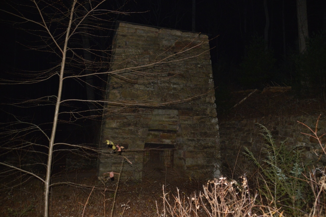
The Roaring Run Furnace is the only remaining piece of the interesting history of the Roaring Run area, in regards to mining.
After the furnace, the trail crosses Roaring Run on an impressive wooden footbridge. I highly admire whoever constructed the trails around Roaring Run. They have done an excellent job, especially with all of the footbridges. At 1.55 miles, the Woodland Trail ends at the information kiosk and four-way trail junction near the trailhead. Here, turn left on the access trail to the trailhead and reach the parking area at 1.6 miles, concluding the hike. Due to the beauty of Roaring Run Falls and the Roaring Run Gorge in general, I decided to rate this hike a "Best Hike"!
Best Hike!

Mileage

0.0 - Roaring Run Day Use Area 
0.35 - Slide on Roaring Run 
0.5 - 35-Foot Slide on Roaring Run 
0.65 - Roaring Run Falls 
1.05 - View of Roaring Run Gorge
1.5 - Roaring Run Furnace
1.6 - Roaring Run Day Use Area

Variations

Hike out and back to Roaring Run Falls via the Streamside Trail - 1.3 Miles

Bonus Stops

There are several other trails in the area that could be hiked, including the Craig Creek Trail and Hoop Hole Trail (that consists of a shorter lower loop and longer full loop). 

Pictures

My apologies for the darkness of some pictures. I did this hike in the early evening, starting at around sunset, and I didn't have enough light to take good pictures of some of the sights along this hike. 
0 Comments


Leave a Reply.

    About Me

    Mark Oleg Ozboyd
    I'm an avid outdoor explorer and a hobbyist landscape photographer. I'm 21 years old and have been hiking since 2011. Originally based out of Atlanta, Georgia, I started out by occasionally hiking short trails throughout well-known Georgia State Parks. During 2012 and 2013, I began to expand my trips into adjacent states, as well as into the wilder National Forest areas rather than just State Parks. Throughout the years that followed, as I slowly ran out of popular hiking trails in my area, I began to search for and hike in more seldom-visited areas. Today, you can find me out in the woods every weekend, whether it's on an official trail or bushwhacking through cross-country terrain without any paths. I now attend Washington & Lee University and am exploring Virginia and West Virginia. My other hobbies include chess, science, old music, and meteorology. I have 3 years of amateur weather forecasting experience, having studied a lot of meteorology basics over the years. I am also a student at European School of Music where I learned that music and nature have a lot in common. Listening to good music inspires me to capture nature's beauty on the camera in different aspects that also make me recall many beautiful music pieces that I've heard.​


    Dear readers: I have invested a tremendous amount of time and effort in this website and the Georgia Waterfalls Database the past five years. All of the work that has gone in keeping these websites updated with my latest trip reports has almost been like a full-time job. This has not allowed me to pick up a paid job to save up money for college, and therefore, I I've had to take out loans. If you find the information on this website interesting, helpful, or time-saving, you can say "thanks" and help me out by clicking the button above and making a contribution. I will be very grateful for any amount of support you give, as all of it will apply toward my college tuition. Thank you! 

    Enter your email address to subscribe for trail reports:

    Delivered by FeedBurner


    Picture
    Coming in 2022-2023?

    Other Hiking Websites

    DWHike's Adventures
    Florida's Natural Wonders
    Florida Trailblazer
    Meanderthals
    Mountain Images
    by Bernie Boyer

    North Carolina Waterfalls with
    ​Kevin Adams
    Take-a-Hike!
    Tennessee Landforms
    Waterfall Page
    Waterfall Adventurer
    Zach's Mild Adventures

    Miles Hiked

    Year 1: 540.0 Miles
    Year 2: 552.3 Miles
    ​Year 3: 518.4 Miles
    Year 4: 482.4 Miles
    Year 5: 259.9 Miles

    Archives

    March 2021
    February 2021
    January 2021
    November 2019
    October 2019
    September 2019
    August 2019
    July 2019
    June 2019
    February 2019
    January 2019
    December 2018
    November 2018
    October 2018
    August 2018
    July 2018
    June 2018
    May 2018
    April 2018
    March 2018
    February 2018
    January 2018
    December 2017
    November 2017
    October 2017
    September 2017
    August 2017
    July 2017
    June 2017
    May 2017
    April 2017
    March 2017
    February 2017
    January 2017
    December 2016
    November 2016
    October 2016
    September 2016
    August 2016
    June 2016
    May 2016
    April 2016
    March 2016
    January 2016
    December 2015
    November 2015
    October 2015
    September 2015
    August 2015
    July 2015
    June 2015
    May 2015
    April 2015
    March 2015
    February 2015
    January 2015
    December 2014
    November 2014
    October 2014
    September 2014
    August 2014
    July 2014
    June 2014
    May 2014
    April 2014
    March 2014
    February 2014

    Categories

    All
    Adel
    Adirondack Park
    Alabama
    Alfred A. Ring Park
    Allegheny Trail
    Amicalola Falls State Park
    Anniston Area
    Apalachicola Bluffs And Ravines Preserve
    Apalachicola National Forest
    Apalachicola/Port St. Joe Area
    Apopka
    Appalachian Trail
    Appling
    Art Loeb Trail
    Aska Trail System
    Bakersville
    Balm-Boyette Scrub Preserve
    Balsam Lake Recreation Area
    Bankhead National Forest
    Bartow County Parks
    Bartram Trail
    Basinger
    Beersheba Springs
    Benton
    Benton Mackaye Trail
    Berry College Trail System
    Best Hike
    Big South Fork National Recreation Area
    Black Bear Wilderness
    Black Rock Mountain State Park
    Blairsville
    Blakely
    Blood Mountain Wilderness
    Blowing Rock
    Blue Ridge
    Blue Ridge Parkway
    Boone
    Bradenton
    Bradenton Beach
    Brasstown Bald
    Brasstown Wilderness
    Brevard
    Bryson City
    Buchanan
    Bucks Pocket State Park
    Bulow Creek State Park
    Bulow Plantation Ruins State Park
    Caesars Head State Park
    Caladesi Island State Park
    Calhoun
    Camel's Hump State Park
    Cashiers
    Caspersen Beach Park
    Catfish Creek State Park
    Caves
    CC Putnam State Forest
    Cedar Point Environmental Park
    Chatsworth
    Chattahoochee National Forest
    Chattanooga
    Chattanooga Valley
    Chattooga National Wild And Scenic River
    Cheaha Wilderness
    Cherohala Skyway
    Cherokee
    Cherokee National Forest
    Chiefland Area
    Chillhowee Recreation Area
    Chipley
    Chunky Gal Trail
    Circle B Bar Reserve
    Citico Creek Wilderness
    Citrus Wildlife Management Area
    Clarkesville
    Clayton
    Cleevland
    Cleveland
    Cloudland Canyon State Park
    Cohutta Wilderness
    Collier-Seminole State Park
    Cordele
    Cornelia
    Covington
    Crestview Area
    Crew-land-and-water-trust
    Cullowhee
    Cumberland Trail
    Dahlonega
    Dalton
    Dawson Forest Wildlife Management Area
    Dawsonville
    Dayton
    De Soto National Memorial
    DeSoto State Park
    Dillard
    Double Springs
    Ducktown
    Duncan Ridge Trail
    Dunlap
    Eagle's Rest Park
    Eastpoint
    Econfina Creek Wildife Management Area
    Eglin Air Force Base
    Elizabethton
    Elkins
    Elk Knob Game Lands
    Elk Park
    Ellicott Rock Wilderness
    Ellijay
    Emerson Point Preserve
    Englewood Area
    Enota Retreat
    Erwin
    Falling Waters State Park
    Fayetteville
    Fires Creek Recreation Area
    Fire Tower
    Flint River
    Florence Area
    Florida
    Florida Caverns State Park
    Florida Trail
    Foothills Trail
    Fort Mountain State Park
    Fort Myers Area
    Fort Payne
    Fort Payne Area
    Fort Yargo State Park
    Franklin
    Franklin Delano Roosevelt State Park
    Franklin-Marion State Forest
    Frozen Head State Park
    Gainesville
    Gainesville Area
    Gatlinburg
    George Washington National Forest
    Georgia
    Georgia Veterans Memorial State Park
    Glasgow
    Gorges State Park
    Grandfather Mountain State Park
    Great Smoky Mountains National Park
    Greeneville
    Green River Game Lands
    Gruetli-Laager
    Grundy Forest State Natural Area
    GTM Reserve
    Guana River Wildlife Management Area
    Hayesville
    Helen
    Hiawassee
    High Falls State Park
    Highlands
    Highlands Scenic Highway
    Hillsborough River State Park
    Hinson Conservation & Recreation Area
    Historic Sites
    Honeymoon Island State Park
    Hot Springs
    Huntington
    Inverness Area
    Jackson
    Jasper
    Jefferson National Forest
    Joan M. Durante Park
    Jonathan Dickinson State Park
    Jones Gap State Park
    Joyce Kilmer Slickrock Wilderness
    Joyce Kilmer - Slickrock Wilderness
    Juniper Prairie Wilderness
    Kelly Park
    Keown Falls Recreation Area
    Kolomoki Mounds State Park
    LaFayette
    Lake City Area
    Lake George Wild Forest
    Lake June-in-Winter State Park
    Lakeland Area
    Lake Placid
    Lake Russell Wildlife Management Area
    Lake Wales Ridge State Forest
    Laurel Fork North Wilderness
    Leffis Key Preserve
    Leon Sinks Geological Area
    Lexington
    Lineville
    Linville
    Linville Gorge Wilderness
    Lithia Springs
    Little Frog Wilderness
    Little Manatee River State Park
    Little River Canyon National Preserve
    Longboat Key
    Long Trail
    Lookout Mountain
    Lookout Mountain Battlefield
    Lovingston
    Lula Lake Land Trust
    Lumpkin
    Maggie Valley
    Manatee Springs State Park
    Marianna Area
    Mark Trail Wilderness
    Marlinton
    Mccaysville
    McMinville
    Mentone
    Middlesex
    Mistletoe State Park
    Monongahela National Forest
    Montreat
    Mountain Bridge Wilderness Area
    Mountain City
    Mountains To Sea Trail
    Mountains-to-Sea Trail
    Mount Rogers National Recreation Area
    Myakka River State Park
    Myron B. Hodge City Park
    Nantahala National Forest
    Naples
    Naples Area
    Natural Bridge State Park
    Neal Preserve
    New Castle
    Newport
    New River Gorge National Park
    New York
    North Carolina
    Ocala Area
    Ocala National Forest
    Ocean-to-Lake Trail
    Oconee State Park
    Oconee Station Historic Site
    Okaloacoochee Slough State Forest
    Oldsmar
    Oneida
    Orlando Area
    Ormond Beach
    Oscar Scherer State Park
    Oxford
    Palatka
    Palmetto Trail
    Panama City Area
    Panthertown Valley
    Parrish
    Paynes Creek Historic State Park
    Peaks Of Otter Recreation Area
    Pigeon Crockford Mountain Wildlife Management Area
    Pigeon-Crockford Mountain Wildlife Management Area
    Pigeon-Crockford Wildlife Management Area
    Pine Mountain
    Pinhoti Trail
    Pinnacle Park
    Pisgah Civitan Park
    Pisgah National Forest
    Pittman Center
    Pond Mountain Wilderness
    Ponds/Lakes
    Prentice Cooper State Forest
    Providence Canyon State Park
    Pumpkintown
    Quick Point Nature Preserve
    Raven Cliffs Wilderness
    Reed Bingham State Park
    Reliance
    Rice Creek Conservation Area
    Riverview Pointe Preserve
    Robbinsville
    Robinson Preserve
    Rock Creek Gorge Scenic Area
    Rock Island State Park
    Rome
    Rosman
    Sale Creek
    Salem
    Salt Springs
    Saluda
    Santa Rosa Beach
    Sarasota
    Sarasota Area
    Savage Gulf State Natural Area
    Scenic Views
    Scottsboro Area
    Sebring Area
    Sewanee
    Sheltowee Trace Trail
    Shining Rock Wilderness
    Signal Mountain
    Sipsey Wilderness
    Sky Valley
    Smithgall Woods State Park
    Snowbird Backcountry Area
    Soddy Daisy
    Soddy-Daisy
    Sopchoppy
    South Carolina
    South Cumberland State Park
    Southeastern Cave Conservancy
    Southern Nantahala Wilderness
    Sparta
    Sprewell Bluff Park
    Spring City
    Spring Hill
    Springs
    Spruce Pine
    Standing Indian Backcountry Area
    St. Augustine
    St. George Island State Park
    St. Joseph Bay State Buffer Preserve
    St. Marks Area
    St. Marks National Wildlife Refuge
    Stone Mountain
    Stone Mountain Park
    Suches
    Sumatra
    Sumter National Forest
    Suwannee River
    Swallow Creek Wildlife Management Area
    Sweetwater Creek State Park
    Sylva
    Talladega National Forest
    Tallahassee Area
    Tallulah Falls
    Tallulah Gorge State Park
    Tampa Bay Area
    Tate City
    Tate's Hell State Forest
    Tea Creek Wildlife Management Area
    Tellico Plains
    Tennessee
    Thomaston
    Toccoa
    Topsail Hill State Park
    Torreya State Park
    Townsend
    Tracy City
    Tray Mountain Wilderness
    Trenton
    Triple Creek Preserve
    Troutdale
    Unaka Mountain Wilderness
    Upper Tampa Bay County Park
    Venice
    Vermont
    Virgin Falls State Natural Area
    Virginia
    Virginia Outdoors Foundation
    Vogel State Park
    Wakulla Springs State Park
    Waleska
    Walhalla
    Wartburg
    Water Features
    Waynesville
    Weedon Island Preserve
    Weeki Wachee Preserve
    Wekiwa Springs State Park
    West Palm Beach Area
    West Virginia
    Whitehall
    White Springs
    Winder
    Withlacoochee State Forest
    Young Harris

    RSS Feed

TRAIL REPORTS

Hikes in Alabama
​Hikes in Florida
Hikes in Georgia
Hikes in North Carolina
Hikes in South Carolina
Hikes in Tennessee
Hikes in Virginia

Hiking Resources

Alabama Resources
​
Florida Resources
Georgia Resources
North Carolina Resources
​South Carolina Resources
​
Tennessee Resources

Other

Contact
Map of Hikes
Alphabetical List of Hikes
Southeast Nature Society
© COPYRIGHT 2014-2018
​ALL RIGHTS RESERVED.
Important: I disclaim any responsibility for any damage or personal injury that may occur as a result of the activities and information found on this website. All outdoor activities, especially off-trail hiking, are done at your own risk. Never hike or head into that area that may be above your fitness or experience level.
  • Home
  • Trail Reports
    • Best Hikes
    • Hikes with Scenic Views
    • Hikes with Water Features
    • Alabama
    • Georgia
    • Florida
    • North Carolina
    • South Carolina
    • Tennessee
    • Vermont
    • Virginia
  • Map
  • Hike List
  • Testimonials
  • Resources
  • Contact Us
  • Southeast Nature Society
    • Our Team
  • Georgia Waterfalls Database