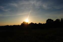
 The Pigeon-Crockford Mountain Wildlife Management Area lies on some of the southernmost extents of the Cumberland Plateau in Georgia. Even though the elevations are generally at or lower than 2000 feet across this area, it is still quite beautiful. The WMA has numerous hiking trails, and while many are not particularly interesting, they are not excessively hard, relaxing, with some rewards. In terms of wildlife, deer and turkeys are abundant, although there are a few bears as well. This hike occurred on Saturday, June 14th, 2014. My plan was to start my hike at the Hood Overlook, and follow the Atwood trail to the Hood Trail. From there, I would follow the Hood Trail to the southern end of the Atwood Trail, and follow the Atwood Trail back to the Hood Overlook. Along the way, I would stop at Allen Creek Falls. R/T Length of Trail: 6.5 Miles Duration of Hike: 3 Hours, 40 Minutes Type of Hike: Loop with Small Spur Difficulty Rating: 5 out of 10 Pros: No prolonged ascents or descents; frequent blazes; panoramic views and small waterfall; lack of people (we saw no one the entire hike on a beautiful Saturday afternoon) Cons: Eroded trail sections; several short, but steep, eroded ascents/descents; Somewhat confusing signage; poorly-marked trail in wildlife clearings; two stream crossings, with one almost knee deep Beginning Point: Hood Overlook on West Brow Road Directions: From Lafayette, GA: Follow GA State Route 193 for 2.8 miles until Chamberlain Road. Turn left onto Chamberlain Road, and follow it for 3.4 miles until Rocky Lane. Turn right onto Rocky Lane, and follow it for 3.5 miles. Watch out for some ruts in the asphalt. Continue onto West Brow Road (Rocky Lane will turn right) for another 0.2 miles until Hood Overlook, and the large parking area on the left. The first time I found out about Pigeon-Crockford Mountain Wildlife Management Area was through the TV show Storm Stories on The Weather Channel. Does that make any sense? Well, they were talking about a group of people, who went into a cave in the WMA (Possibly Ellison Cave?), and all of the people but one got stuck in the cave, because of flash flooding that blocked the cave opening. I believe that the one who was left outside managed to get help. Quite a story! Anyway, that's how I first found out about this place, but I didn't know it had any relatively good trails, until a friend told me about the loop hike I am about to write about. I was expecting it to be easy (after all the hard hikes the past few weeks). Certainly it was much easier, but not as easy as I expected! The drive to the trailhead is quite exciting in its own. Rocky Lane, the road that leads to the top, is a narrow and very winding road, with numerous switchbacks. Although it is paved, there are some ruts/cracks/bumps in spots. Also, when I was here, there were a few fallen tree branches, some large, across portions of the road, but they were passable. Once you get onto West Brow Road, it becomes gravel, but it is manageable by pretty much all vehicles. Once you park, you can go and check out the path to the Hood Overlook, but that is not where the trail starts. In fact, finding the trail can be confusing, if you are not familiar with the area. Once you are parked, walk up the West Brow Road the way you came from, and you'll see another small parking lot on the left. Turn left here, and walk into a grassy area. If you follow the edge of the grassy area to the forest line, you will see a trail marker for the Atwood Trail and a couple of blue blazes. The trail starts off by ascending into another field, a bigger one this time. This was honestly one of the most confusing places on the entire trail. There were no pathways across the field, and there were no signs or blazes either. It took me a while to figure it out, but you have to turn right when you get onto the field, and follow the border of the forest and the field. Once you come to the corner of the field, don't turn left, but continue going forward on an old road. This is the trail, and the blue blazes reappeared shortly. Even though most if not all of this hike was on old roads, they were barely noticeable in many areas. The old road quickly became a trail,and started descending. At first the descent was gentle, but at 0.3 miles, the trail turned sharply left, and a steeper descent commenced. The trail crossed a small stream at the end of the descent at 0.5 miles, and a brief, eroded, and steep ascent followed. That ascent lasted 0.1 miles, before the trail flattened out again and reached the junction with the Hood Trail at 0.8 miles. The Atwood Trail turned right, while the Hood Trail continued forward. The blazes, although frequent, were confusing, to say the least on this hike. The Atwood Trail was blue-blazed all the time, but somehow the Hood Trail had both red-orange AND blue blazes..? While descriptions said that Atwood Trail should be red-orange blazed and Hood Trail should be blue-blazed? I wasn't sure what the deal was here, but the rule pretty much was if you see any red blazes on the trail, it's the Hood Trail, while if it is just blue, it is the Atwood Trail. One good part about the trail system here is that there were frequent mileage markers, which helped me to figure out how much I hiked. The Hood Trail started off flat, but the key part is "started off". The flat gave way to a gentle descent at 0.9 miles from the start, and the gentle descent gave way to a steep and very eroded descent. The trail became rutted, very steep, and quite muddy as it "precipitated" into the Allen Creek valley. Fortunately, this descent didn't last long, but it was enough to make my boots very muddy. At 0.3 miles from the start of the Hood Trail, the descent slackened, and the trail now followed the stream until it rounded the corner, and... there it is! Two smaller streams joined here to form one large Allen Creek. There was definitely no way to cross here without getting wet, although if you bushwhack upstream along the right hand stream, there did seem to be a somewhat uncertain way of rock hopping. I decided to just wade through. The water was just above my ankles, although in the deepest part it was just shy of my knees. Also, there is a trail junction at this crossing. the Connector Trail goes to the left of the stream towards Atwood Trail in a mere 100 yards. That significantly shortens the length of the loop, if you want a shorter hike. Meanwhile, the Hood Trail continues across the stream bearing right. Take the Hood Trail. The trail follows the stream for a bit, but then it turns sharply right, and starts a steep and equally eroded ascent back to the ridgeline. Once again, it lasted only 0.1 miles, but it was still not too easy. At 1.4 miles, the trail reached the ridgeline and turned left. An unofficial path continued forward. The path is supposed to connect to Rocktown, which is also an interesting attraction, but I didn't go today. The next mile of the Hood Trail was quite easy, with only a couple fallen trees and no ascents or descents. The trail just followed the ridgeline. That has to end though, right? In about a mile from the start of the easy section, the sounds of creeks from both the left and right became loud, and a descent started again. This one wasn't as steep or eroded as the ones earlier, so it was actually relaxing. In another 0.2 miles (1.8 miles on the Hood Trail now and 2.6 miles from the start), the trail reaches the creeks. This was another confusing spot. According to my maps, if you want to get to the West Brow Trail, you need to hike up the smaller creek bed to the right, and you'll see it go away to your left. I never saw where that was, but it wasn't my plan to go there anyway. The Hood Trail ended here, and I turned left hiking straight down this small creek bed to Allen Creek. Across Allen Creek, I could see a sign for the Atwood Trail. However, between me and that sign, there was rushing water. I carefully waded through again. There were lots of slippery rocks here, which made things more difficult than in the first crossing. I made it across fine though. As far as I understood, the Atwood Trail actually started here, not at the parking lot where I parked. This was confusing, but regardless, just know that you will have to follow Atwood Trail and blue blazes for the rest of the way. Right after this sign, the trail becomes a mess. It appears that this section is a very muddy stream bed, so I had to try hop and skip from bank to bank of the bed until it was over. Luckily, that wasn't long. After this, the trail followed the edge of the stream for 0.2 miles. At 0.2 miles from the stream crossing, the Atwood Trail turns sharply left. However, don't do that yet! An unsigned old road continues forward to Allen Creek Falls. Follow this road to a path that goes right. Follow this path through a partially overgrown campsite and exit out onto Allen Creek. This is Allen Creek Falls. It is not a big falls, but nice regardless. I was now 2.9 miles from the start of the hike. From Allen Creek Falls, I went back the way I came to the Atwood Trail, and turned right onto the Atwood Trail. The trail quickly left Allen Creek, and started a relatively long but gentle ascent. At least nothing was eroded here. The ascent continued for a mile through an open forest with sporadic views until it reached the end of the climb 4 miles into the hike. However, the end of the climb brought confusion. The wide, flat summit of this unnamed "hill" on the plateau had a big wildlife opening, and I had no clue where the trail went, because there were no signs. My best guess was to turn left and follow the edge of the opening, because that was how it looked like on my map. Along the way, I saw numerous wildflowers in the field, including daisies. And then, suddenly the trail turned left into the forest, and a brief descent followed. However, it wasn't long before the trail exited into another even bigger wildlife opening, with still no signs of where to go. Ugh. First, I captured the sunset from the field. There were also good views to the west. Afterwards, I tried figuring out where the trail went, and there were faint signs of a path along the left edge of the field, so I turned left and followed the edge. On the far end of the field, the trail turned into the forest, and blazes reappeared. I sure hoped there would be no more of these openings! The descent was steady, for 0.5 miles.Then there was a small brook crossing, followed by several short, but steep ups and downs in the course of a mile. 5.5 miles into the hike, the trail reached the lowest pint of the descent where there was a trail junction. Remember the Connector Trail that I talked about, when I was on the Hood Trail? Well, that Connector Trail came out here. It takes you to Allen Creek and the Hood Trail in 100 yards. Meanwhile, the Atwood Trail turned right and began another ascent. There was another wildlife opening shortly! Again no blazes, but I kept following the right edge of the opening. At the far end of this side, there was a forest road, and that was where the trail went. The rest of the hike was easy. The old road was bulldozed recently apparently, because the bulldozer tracks were still somewhat fresh The road gently ascended the next 0.7 miles. 0.7 miles from the last junction, the trail passed a wildlife opening on the left and reached a gate. The trail went around the gate and opened up on West Brow Road. From here, it was a short walk up West Brow Road (around 0.2 miles) back to the parking area. In summary, this is a very enjoyable, and not very hard hike. While certainly there are some descents and ascents, none have a combination of too steep and too long. Hood Overlook and Allen Creek Falls are worth the visit, and although the crossings of Allen Creek do slow things down a bit, they only spice up the adventure. Below is my picture gallery from the hike, as well as a video of Allen Creek Falls!
2 Comments
Angela
3/11/2022 09:00:12 pm
Thank you and please correct to Crockford-Pigeon Wildlife Management Area 8/3/2022 06:02:32 pm
Edirne ECA servisi hizmetlerimiz memnuniyet odaklıdır. Detayları incelemek için hemen web adresimize göz at! https://www.edirneklimaservisi.com/edirne-eca-servisi/ Leave a Reply. |
About MeMark Oleg Ozboyd Dear readers: I have invested a tremendous amount of time and effort in this website and the Georgia Waterfalls Database the past five years. All of the work that has gone in keeping these websites updated with my latest trip reports has almost been like a full-time job. This has not allowed me to pick up a paid job to save up money for college, and therefore, I I've had to take out loans. If you find the information on this website interesting, helpful, or time-saving, you can say "thanks" and help me out by clicking the button above and making a contribution. I will be very grateful for any amount of support you give, as all of it will apply toward my college tuition. Thank you!

Coming in 2022-2023?
Other Hiking WebsitesMiles HikedYear 1: 540.0 Miles
Year 2: 552.3 Miles Year 3: 518.4 Miles Year 4: 482.4 Miles Year 5: 259.9 Miles Archives
March 2021
Categories
All
|
 RSS Feed