Cohutta Wilderness: East Cowpen - Panther Creek - Conasauga River Trails Loop, Ellijay, Georgia4/30/2014 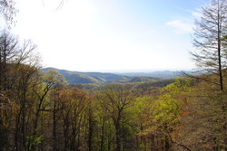 The Cohutta Mountains in North Georgia are considered as some of the oldest mountains in the world. They are part of the Cohutta Wilderness, which is part of the Chattahoochee National Forest. With nearly 100 miles of occasionally traveled trails that drop from high ridgetops to valleys full of rushing mountain water... the Cohutta Wilderness has some of the most interesting hiking opportunities in Georgia. This hike occurred on Saturday, April 26, 2014. My plan was to park at the East Cowpen Trailhead (Three Forks on USFS 64) and follow the East Cowpen Trail to the Panther Creek Trail. From there, I would take the Panther Creek Trail down into the Conasauga River Valley, and follow the Conasauga River Trail south to the Betty Gap trailhead on USFS 64. I would finish of the hike by hiking the portion of USFS 64 between Betty Gap and Three Forks back to the starting point. R/T Length of Trail: 12.5 Miles Duration of Hike: 7 Hours, 40 Minutes Type of Hike: Loop Difficulty Rating: 10 out of 10; very challenging, deep river crossings, steep ascent Beginning Point: Three Forks on USFS 64 Directions: From Atlanta, GA: Take I-75 to I-575, and follow I-575 up into North Georgia. I-575 will become Route 515. In Elijay, take a left onto Soule Bridge, and immediately another left onto GA Route 52. In downtown Elijay, take the second exit to the right on the roundabout. Follow GA 52 for 5.2 miles until Gates Chapel Road. Turn right onto Gates Chapel Road and follow it for 5.4 miles. When pavement will end, keep right onto Wilderness Trl. Follow it for 1.5 miles, and then take a right onto Old CCC Camp Road. Follow it for 3.2 miles to the top of the mountain and USFS 64. Turn right onto USFS 64, and follow it for 4.2 miles until you will see a large parking lot on the left of the road, while the road itself sharply switchbacks to the right. This is Three Forks. This is an extremely hard trail. Yes, it is very, very hard. I reserve wording like this and the "10 out of 10" rating for only the very hardest trails, and yet, I find it more than needed to put them in this post. This trail is one of the hardest - if not the hardest - I have ever hiked. The trail starts with a gradual ascent, and then a nice and long descent. Everything's fine all the way to Panther Creek Falls. Yes, the descent does get steep at times, but everything's manageable. After the top of Panther Creek Falls? Not so much. The deterioration of the hike starts with a descent almost vertically downhill right after Panther Creek Falls. And then, on the Conasauga River Trail, you will run into 18 river crossings, most with water approaching your knees. And well, you finish it off with a climb that is about as steep, if not steeper than the descent from Panther Creek Falls. I do recommend hiking this trail, but... but... but... if you are a novice, the best choice is to just hike out and back to Panther Creek Falls. The rest is for the more experienced hikers. The trailhead for this hike is Three Forks on US Forest Service Road 64. It is a long drive on unpaved roads no matter which direction you come from, but at least the road is in great condition and manageable by pretty much any vehicle with caution. The parking lot has space for 7-8 cars. I think you can park on the shoulder if the parking lot is full, as it can get pretty busy on weekends. The first trail you will be hiking is the East Copwen Trail. It starts off with a gradual but steady ascent up the mountain. At around 0.5 miles from the start, the Rough Ridge Trail will branch off to the right. This trail goes in the direction of Jacks River, and eventually reaches it. I continued the steady climb up the East Cowpen Trail. At 1 mile from the start, the trail passed through a gap and starting heading downhill. It was pretty clear that this trail was an old road. Probably many dozens of years ago, it was used for logging operations, as much of the Cohutta Wilderness was logged extensively back in the early 1900s and 1800s. Also, the forest along the trail was see through. I could see all the valleys on both sides of the ridge. I like trails like this. At 2.2 miles from the start, there was a trail junction with the Panther Creek Trail. The East Cowpen Trail continued northward towards jacks River and the Beech Bottoms area, but for the purpose of this hike, I turned left onto the Panther Creek Trail. The Panther Creek Trail started off decently. The descent was very gradual as the trail followed the contours of the ridgeline. However, 0.6 miles from the junction, BUMP! The trail crossed the roots of a large tree (which were used as a step too), and a sudden steep descent started. Nothing horrible, but there was some pressure on my knees as the trail went straight down the mountain. There were no switchbacks. There was a short section, where I had to jump down in order to get down the trail safely. Another 0.6 miles from the start of the steep section, the trail reached a gap. You would think the descent would temporarily stop here, and the trail would go upwards. Nope! Don't go forward, because that isn't the trail. It is just a fake side path. The official trail turned left. There was a series of steps, which helped to ease the descent a little bit. 3.7 miles from the start of the hike, and about 1.5 miles since the Panther Creek Trail junction, the trail crossed Panther Creek - barely a trickle - and leveled out considerably. Don't expect this too long, though. So far, everything was more or less manageable, although certainly, ascending back up this trail would be very, very hard. The trail quickly crossed panther Creek via rock hop again. Here, there was a bunch of campsites. Apparently, I lost the trail somewhere, because I soon found that out after Panther Creek Falls. It is very easy to lose the trail among the campsites, because there's lots of small paths going everywhere. I might have followed the correct trail and lost it later... I am not entirely sure. The trail reached an area full of boulders, This was the top of Panther Creek Falls. I walked to the rock outcrop at the top, and here there was both a view of the falls and of the mountains. Usually, you don't see both a waterfall and an overlook at one spot. After the waterfall, I went back to the boulders and tried figuring out where the trail went. Either I lost the trail somewhere before, or there was no designated trail in this place. Every path down the bluffs looked the same, and I just went down the easiest path. Along the way, I stopped at a nice view of the falls from its base. The trail kept going down the bluffs, and it was even steeper than the previous sections before Panther Creek Falls. And then all of a sudden, the little path I had been following came out onto a maintained path, which looked much more like the trail. Where did that come from?? I wasn't sure where I missed a turn in the trail, but luckily, I still made it back onto the right path. Immediately, the trail crossed Panther Creek again via rock hop. After that, a gradual descent started. This was a welcome sight after the stumbling down the bluffs of Panther Creek Falls. At 2 miles from the start of the Panther Creek Trail and 4.2 miles from the start of the hike, the descent finally ended, and there were several more crossings of Panther Creek. Each had some well placed stones for the crossing. You made it this far without getting your feet wet, but don't count on still being dry by the time you finish this hike. After 4 rock hops over Panther Creek, the trail reaches the mouth of Panther Creek, where it empties itself into the Conasauga River. Here, the Panther Creek Trail crosses the Conasauga River. Just like all other crossings ahead, this crossing had water up to my knees at the deepest part. On the other side of the river, the Panther Creek Trail dead ended into the Conasauga River Trail. By now, it was 5.3 miles since the start of the hike. The easier part came to an end, and the much harder section started. If turning right onto the Conasuaga River Trail, it would go down the river towards Jacks River and Beech Bottoms. Turning tot he left, it would lead toward the headwaters of the Conasuaga River and Betty Gap on USFS 64. This was where I planned to go. What I didn't plan, though, is how slow I would hike this part of the trail. Almost immediately after I turned onto the Conasuaga River Trail, there was a crossing of the river. And so it began. Back and forth, back and forth. Every 5-10 minutes (or sooner), there was a crossing onto the other bank. It's hard to list a good description for this part of the trail, because there isn't much to describe. The trail never went too far from the river, and most of the times, followed its bank. Luckily, there were a few ancient blazes on some of the river crossings, which detailed where to cross to. Not sure how they were allowed in the Wilderness. However, with all of the deep crossings, this trail was very slow. It was flat for the most part, but each crossing took a lot of time. Around 12-13 crossings from the start of the Panther Creek Trail end, there was a particularly confusing section. I spent a long time walking back and forth, trying to figure out what to do. It seemed like the trail wanted to cross the river, but it didn't. On the other bank there was a campsite, so that's why I knew the trail was here. Finally, I found where it went almost unnoticeable over a tributary of the Conasauaga River. Soon, there was yet another crossing (I lost count by now of how many there were, but somebody told me there were 18). After this crossing, the trail took an uphill trend. The river was rising, and so was the trail. There were some moderately steep sections in spots. Soon, there was a junction with the Chestnut Lead Trail. This trail turns right and goes to another trailhead on USFS 64, further west than the one I was trying to get to. I kept following the Conasauga River Trail, though. There were a couple more crossings of the now half-dead Conasauga River. It was just a small stream by now. After the last crossing, the ascent got real. It quickly became one of the steepest ascents I remember hiking, and it was very tiring, especially as it was closer the end of the hike, after already hiking 9 miles. Just before the ascent ended, the Conasauaga River became a trickle, and the ascent just seemed getting steeper and steeper. And then all of a sudden, the trail popped out onto USFS 64. Well, I made it. I seriously don't know how I didn't get lost down the Conasauaga River. It was very easy to get lost. However, the bad news were that I still had to hike 2.8 miles on USFS 64 back to Three Forks. So far this day, I had hiked 9.7 miles. There were several climbs on this stretch of USFS 64. None were steep, but some were pretty long. In between each climb, there was a short descent. The last 0.5 miles were a nice descent back to the trailhead. In summary, this is a very demanding hike, but also a very, very hard hike. If you want to hike this trail, make sure you know how to cross deep rushing rivers, and make sure you will have enough energy to accomplish that burning climb in the end. If you are a novice, I wouldn't recommend hiking this trail - just out and back to Panther Creek Falls is great. If you plan t odo the whole thing, I hope my description helps you. Below are my pictures. Enjoy!
2 Comments
John Lobello
2/17/2021 09:58:06 pm
Hi there! Loved your writeup. My buddy and I are thinking of doing some of the same trails to summit Bald and Cowpen mountain for the GA 4000 challenge. Would you happen to have a map of your route? Like say a GPS tracker? I know that, given time, I could probably piece together a map, but we like to be thorough. Thanks! 8/3/2022 05:42:46 pm
Edirne ECA servisi için hemen websitemize göz at! https://www.edirneklimaservisi.com/edirne-eca-servisi/ Leave a Reply. |
About MeMark Oleg Ozboyd Dear readers: I have invested a tremendous amount of time and effort in this website and the Georgia Waterfalls Database the past five years. All of the work that has gone in keeping these websites updated with my latest trip reports has almost been like a full-time job. This has not allowed me to pick up a paid job to save up money for college, and therefore, I I've had to take out loans. If you find the information on this website interesting, helpful, or time-saving, you can say "thanks" and help me out by clicking the button above and making a contribution. I will be very grateful for any amount of support you give, as all of it will apply toward my college tuition. Thank you!

Coming in 2022-2023?
Other Hiking WebsitesMiles HikedYear 1: 540.0 Miles
Year 2: 552.3 Miles Year 3: 518.4 Miles Year 4: 482.4 Miles Year 5: 259.9 Miles Archives
March 2021
Categories
All
|
 RSS Feed