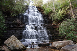
 In the Ocoee District of the Southern Cherokee National Forest in Tennessee is the Ocoee River. It is surrounded by the mountains of the Chillhowee Ridge to its north, and the Cohutta Mountains to its south. While the Chillowhee Mountains are not high at all, just above 2000 feet, it was still rather attractive to check out some of the 20+ miles of trails in the Chillhowee Recreation Area. Benton Falls is the key attraction in the area, as Clear Creek tumbles 65 feet down a natural rock ledge. This hike occurred on Saturday, March 15th, 2014. My plans were to park at the Gazebo Overlook trailhead on Oswald Dome Road, to take the Gazebo Trail to McKamy Lake, then take Benton Falls Trail to Benton Falls, followed by Clemmer Trail to Rim Rock Trail, then take Rim Rock Trail to Clear Creek Trail, and finally use Clear Creek Trail to get back to the trailhead. SummaryR/T Length of Trail: 8 Miles Duration of Hike: 3:30 Type of Hike: Loop Difficulty Rating: 3 out of 10 Pros: All trails are easy to follow and well-marked Cons: There is one relatively steep ascent following a ford of Rock Creek Points of Interest: Benton Falls - 8 stars Trail Blaze Color(s): Gazebo Trail - Dark Blue; McKamy Lake Trail - White; Benton Falls Trail - Blue; Clemmer Trail - Green; Rim Rock Trail - Gray; Clear Creek Trail - Pink; Arbutus Trail - Orange; Elderberry Trail - Dark Gray Best Season(s) to Hike: Spring; Summer Fees: If you start your hike at the Chillhowee Recreation Area/McKamy Lake, you will have to pay a $3 fee per vehicle. No fee is charged at the Gazebo Trailhead. Beginning Point: Gazebo Overlook on Oswald Dome Road Directions: From Cleveland, TN: Take US 64/74 East to the community of Ocoee. Once there, take US 411 North and drive 5.7 miles to Benton. Take a right onto Main Street, and then at the T-shaped intersection, take another right onto TN 314. Drive on TN 314 for 1 mile, and then take a left onto Benton Springs Road. Benton Springs Road will become gravel as soon as it starts climbing, and you will see a sign "High Clearance Vehicles". Do not worry, almost all vehicles can make it up this road, if driving with care. Keep following Benton Springs Road to the summit, and at the T-shaped intersection, take a left onto Oswald Dome Road. Drive 0.3 miles to the parking lot for Gazebo Overlook, on your left. Trail starts across the road. Details I know in the description of this website I said I hike mainly in North Georgia, and yet so far, that was mainly not the case, since I started my site. The thing is, I have hiked so much in North Georgia, that there's not a lot of interesting trails left. I really like Tennessee and North Carolina more. I will still hike in North GA though, as it is much closer to me. For this weekend, I was thinking about checking out an area I have never been in before: The Ocoee District of the Cherokee National Forest. It is a pretty remote area of Polk County, and while as far as I knew the mountains weren't too high, it was still pretty attractive. There are lots of trails in this area, but the only trail system I ever actually heard of before in this area was the Chillhowee Trail System. While I am sure there are lots of other trail systems in this area, I did not go looking for them now, as I meant to go to Chillowhee Trail System for a while. It was in such a location that pretty much escaped each of my trips, but now that I have been there, I will most likely come back in the future. After examining the Chillowhee Trail Map, I came to the conclusion that in the northern section of the trail system, the main point of interest was Benton Falls, but also the Gazebo Overlook was nice. There was also a trail running along the east side of Rock Creek, along the eastern ridge, so there had to be a way to connect these two together for a loop hike. I concluded that I could make an 8 mile loop hike, by hiking the following trails in order: Gazebo Trail, #146 McKamy Lake Trail, #72 Benton Falls Trail, #131 Clemmer Trail, #302 Rim Rock Trail, #77 Clear Creek Trail, #79 Arbutus Trail, #141 Elderberry Trail, #143 With this being settled, I was off. When I reached the trailhead, I immediately saw what the first connector trail, the Gazebo Trail, was named for. Stone steps led from the trailhead to a large rock outcrop. It had a gazebo, with spectacular views of the valley below. I could see Benton and all the farmlands laid out in front of me. After snapping a few pictures at the overlook, I decided not to waste any more time, and start the trail. There were 8 miles ahead of me. The well-marked Gazebo Trail-head is located across the road from the parking lot. The trail is blazed with a dark blue color, and immediately starts to descend gradually to McKamy Lake. The descent is short and very gradual, but nevertheless, you descend a couple hundred feet, so it may be a bit of a bummer on your way back, as you will be returning by this trail. I reached the campground 0.3 miles from the start, crossed the campground loop road in 0.4 miles and again in 0.5 miles. Once you cross the road the second time, you reach the end of the Gazebo Trail. Here the loop section of the trail starts. The McKamy Lake Loop Trail goes both forward and right. My plan was to return from the right, but meanwhile continue forward. I followed the northern shore of the 7-acre lake for 0.3 miles, and I passed several fishing spots, before I reached the Beach area. Keep left here, and if you plan on going to the beach, make sure you don't bring dogs on it. You will pass the Azalea Trail, #140, branching off to your left. If you are staying in the campground, or want to go for a short hike, you can combine McKamy Lake, Azalea, Clear Creek, and Elderberry Trails for a nice 4 mile loop hike. For the purposes of my hike and this trail description, though, I kept right on the McKamy Lake Trail. Shortly afterwards, you will reach the main trailhead (I did not go to this one, so to lengthen my hike and also to escape the $3 fee), and you will see several trail signs and a large trailhead kiosk. If you go straight, you will have the option to go onto the Elderberry Spur Trail or the Beach Trail, but I went right, onto the McKamy Dam. Once I reached the southeastern corner of the lake, there was a bunch of trail junctions. If you turn right, that will take you around the southern shore of the lake and back to the lower part of the campground from where I came from. Going straight would take you onto the white-blazed Forest Walk Trail, which is 0.4 miles long. The Benton Falls Trail, #131, goes downwards to the left. From here, it was 1.5 miles to Benton Falls, the key attraction of my hike. The Benton Falls Trail is blue-blazed. It was a gradual descent, similar to the Gazebo Trail, except longer. It looks like it was covered in sand purposely as well, although in a lot of places, you will see clay instead. You will pass several trail junctions. The Elderberry Trail, #143, branches off to the left towards the main section of the campground. You will then pass the Slick Rock Naked Widow Loop, #85, entrances on your right. About 2/3 of the way to the falls, you will pass the Redleaf Trail, #144, which is another way to shortcut back to the campground. Finally, you will reach a well-marked intersection at 1.3 miles from the start of the Benton Falls Trail. This is the start of the Clemmer Trail, #302. If you are going to Benton Falls, you will probably know where to go following the signs. If you take a left here, you will be at Benton Falls in 0.2 miles. If you keep going forward, you will be on the Clemmer Trail. I went left, and these last 0.2 miles of the Benton Falls Trail, are not only the steepest on this trail, but possibly the steepest of the whole hike. At 0.1 mile, you will reach some wooden railing to the left. If you are careful, you can go left and you will be at the top of the falls. The rocks are slippery, so be very careful, because if you fall, its 65 feet down. It is an interesting perspective of the falls though. From here, it is another 0.1 mile to the base of the falls. I rounded a switchback, and there it was! The waterfall was decently strong, and the water cascaded down a large cliff, so it looked pretty nice. There was a lot of rocks in Rock Creek, and how it looked to me, once you ford the stream, there is an unofficial shortcut trail that goes up to Clear Creek Trail. I didn't see it on any maps though. After spending a little time at the Falls, I made it up back up those switchbacks and large stone steps back to the Clemmer Trail junction. Part 1 of the hike done. I now went onto the Clemmer Trail, and I came across the worst blaze possible to mark trails, one that I never saw in my 3 years of hiking: Green. It blends with the surrounding vegetation, especially in summer. However, the trail was easy to follow, and that was the thing that mattered. You quickly leave the sandy popular trail to Benton Falls onto a much more natural and more remote trail. You will come to a small branch of Rock Creek. This was an easy crossing, over some well-placed rocks. This was not to be the case later though. The trail goes through a forest that has trees that seem to stand in rows but are not too close together. In a little bit, I came to a crossing of another of Rock Creek's numerous tributaries. This one was a little harder. If there is high water, you might need to wade through. However, the water level was normal, and there was a bunch of small, but slippery, rocks, that were not submerged. This crossing is harder than the first one, but if you will be careful, it is still a piece of cake. After this crossing, you will come to several downed trees, which are easily passable, and about 0.8 miles from the Benton Falls/Clemmer Trail junction, you will reach a junction with the Rim Rock Trail, #77. If you keep going south on the Clemmer Trail, it will eventually take you to Highway 30 near Parksville Lake, but for this hike, I went left (east) onto the Rim Rock Trail. Just when I thought trail blazes can't get any worse, they did! The Rim Rock Trail was blazed with grey, a color for blazes even worse than green. I wonder, if there are any worse blaze colors then grey. The grey blazes blended with the tree bark, so it was very hard to see them in a lot of places. Fortunately, the trail was easy to follow, like the Clemmer Trail. While the Rim Rock Trail drops 200 feet in 0.5 miles, the trail was built very well, rounding the hillside, so the descent is barely noticeable, just like the Gazebo Trail. However, with the gradual descent, the sound of rushing water was increasing. Uh-oh. This wasn't any ol' tributary now, this was Rock Creek itself. And no, there was no footbridge here either. The creek was pretty wide, and while there were different rocks here and there, they were all positioned not in a good way to cross. Eventually, I found a way to cross just to the left of where the trail crosses, but it wasn't very safe. The rocks were shaky, and I barely made it across. You can try crossing on rocks, but it is probably easier to wade through the stream. With this said, you won't cross any creeks again, so if you made it across this one, you are all good! Once I crossed the creek, a gradual climb began to the other side of the valley. The trail kept climbing for 0.5 miles, but it wasn't very hard. While the 4 miles I already hiked were taking a toll, the 200 feet I climbed were very gradual, so it did not really make any problems. Once I topped the climb, there was another trail junction. This junction was the approximate halfway point of the hike. This was also the end of the Rim Rock Trail. If you kept going straight here, you will eventually get in a few miles to the southern Clear Creek trailhead on Highway 30. However, to keep following my loop plan, I took a left here onto the Clear Creek Trail northward. There was a sign that said you'll come to the Chillhowee Campground in 1.8 miles, but it wasn't quite correct. More on that later. The Clear Creek Trail is pink-blazed... thank goodness, finally a normal blaze. There will be no climbing on this trail. In fact, you will be gradually descending. You will cross several dried-out stream beds, that were supposed to be tributaries of Rock Creek. You'll soon hear Benton Falls below you. Slowly, the trail comes to creek level. There will be a large tributary of Rock Creek to your left, but guess what! A footbridge was built across this tributary, so no more creek crossings! They probably built it because there were no rocks in this area at all. In a little bit, you will cross Rock Creek itself over another footbridge. Shortly afterwards, you will reach another trail junction. You have now hiked 1.8 miles from the last trail junction. The Clear Creek Trail turns right, towards the campground, and towards the Azalea Trail. To the left goes the Arbutus Trail, #141. They both take you to the same place, but it seemed to me that the Arbutus Trail is a little shorter in taking you to the campground. Maybe just an illusion. The Arbutus Trail is 0.7 miles long, and is orange-blazed. In 0.3 miles, you will reach a junction with the Redleaf Trail. Remember that when you were going down the Benton Falls Trail? Well here is where it came out. Turn right here to keep following the Arbutus Trail. In 0.4 miles, you will exit onto the southeastern end of the campground. It was 2.5 miles since the Rim Rock Trail junction. Oops, what did that sign say back there? Go along the left side of the road here, and you will shortly come to the Elderberry Trail, #143. Take it. The Elderberry Trail is said to be dark grey-blazed, but it actually looked to me be a light grey, almost white. The next 0.3 miles will be a gradual ascent, although it isn't really much. You will then see a junction with the Elderberry Spur Trail, which will take you to the beach. Keep left below the dam on Elderberry Trail, and in another 0.2 miles, I popped out onto the Benton Falls Trail. This was almost the end of the loop. I climbed up to the dam, and I took the McKamy Lake Trail along the southern shore of the lake this time. In 0.3 miles, I crossed a long footbridge, and pooped out onto the Gazebo Trail. From here, it was 0.5 miles back to the parking lot. While the climb was not hard at all, it was a bummer, like I thought it would be, after nearly 8 miles of hiking. When, I came out onto the parking lot, I realized I did this trail in 3.5 hours. Fast. Probably, because this was a mostly easy hike. In summary, this is a nice hike, if you are looking for some exercises while enjoying nature. It is definitely not hard, and the crossing of Rock Creek on Rim Rock Trail is probably the only thing that makes this trail moderate. So put on your pack, and hike on! Find my pictures below. I included a lot of pictures of trail signs, so you will have a good idea where to go. Variations Hike out and back to Benton Falls - 3 Miles There are many ways to add variations to this hike. Click here to view a map of the Chillhowee Recreation Area Trail System. Bonus Stops If you drive south on Oswald Dome Road, you will pass several great roadside vistas of the surrounding areas including Parksville Lake. Pictures
2 Comments
Jeff
7/3/2015 05:04:51 pm
Thanks Mark, I will be doing an overnight hike on these trails next week. You detailed explanation was very helpful.
Mark Oleg
7/29/2015 06:41:41 am
You're welcome. I hope you enjoyed it! Leave a Reply. |
About MeMark Oleg Ozboyd Dear readers: I have invested a tremendous amount of time and effort in this website and the Georgia Waterfalls Database the past five years. All of the work that has gone in keeping these websites updated with my latest trip reports has almost been like a full-time job. This has not allowed me to pick up a paid job to save up money for college, and therefore, I I've had to take out loans. If you find the information on this website interesting, helpful, or time-saving, you can say "thanks" and help me out by clicking the button above and making a contribution. I will be very grateful for any amount of support you give, as all of it will apply toward my college tuition. Thank you!

Coming in 2022-2023?
Other Hiking WebsitesMiles HikedYear 1: 540.0 Miles
Year 2: 552.3 Miles Year 3: 518.4 Miles Year 4: 482.4 Miles Year 5: 259.9 Miles Archives
March 2021
Categories
All
|
 RSS Feed