HIKING THE APPALACHIANS AND BEYOND
  • Home
  • Trail Reports
    • Best Hikes
    • Hikes with Scenic Views
    • Hikes with Water Features
    • Alabama
    • Georgia
    • Florida
    • North Carolina
    • South Carolina
    • Tennessee
    • Vermont
    • Virginia
  • Map
  • Hike List
  • Testimonials
  • Resources
  • Contact Us
  • Southeast Nature Society
    • Our Team
  • Georgia Waterfalls Database

Southern Nantahala Wilderness: Standing Indian Mountain via Lower Ridge Trail, Franklin, NC

5/29/2014

6 Comments

 
Picture
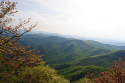
Ahh, there's so many areas that I still haven't explored, including the Southern Nantahala Wilderness, which has escaped my eye up to this hike. The Standing Indian Backcountry Area, along with the Southern Nantahala Wilderness, have both the highest mountain south of the Smokies and the headwaters of the famed Nantahala River. The greenery was superb, when I went here, with few rocks even at the summit. Although the better known Albert Mountain has a fire tower and beautiful views, I decided to tackle the higher and less-visited Standing Indian Mountain, which rivals Albert Mountain in terms of views. There's many ways to access Standing Indian Mountain, although I chose the least-used one. Little did I know how hard it would get. This hike occurred on Saturday, May 25th, 2014. My plan was to park at Standing Indian Campground, and follow the Lower Ridge Trail (#28) all the way to the summit of Standing Indian Mountain and its two overlooks. I would return the same way. 

R/T Length of Trail: 8.5 Miles
Duration of Hike: 5 Hours, 45 Minutes
Type of Hike: Out-and-back
Difficulty Rating: 9 out of 10; Very steep ascent, some rocky and rooty areas
Beginning Point: Parking lot and picnic area near the beginning of Standing Indian Campground
Directions: From Franklin, NC: Follow US-64 West to Old Murphy Road, 12.5 miles after the US-64/US-441 interchange. Turn left onto Old Murphy Road, and follow it for 2 miles until Standing Indian Campground Road. Follow Standing Indian Campground Road for 2 miles until the Standing Indian Campground entrance, and keep right into the campground. The first road that branches off to the left is the parking area.
I've been hiking for 3 years, and I have failed to discover a lot of impressive trail systems. I think I still haven't discovered every. The Standing Indian Backcountry Area is a good example. As I now found out, it has an extensive trail system, including trails within the boundaries of the Southern Nantahala Wilderness. When I decided to go to this area, I had a hard time deciding which trail to choose, as there were numerous options. I decided for Standing Indian Mountain, the highest mountain south of the Smokies at 5499 feet high. There's several ways to get to Standing Indian Mountain. The shortest and easiest way is from Deep Gap Trailhead on Forest Service Road 71. Another option is to go from Forest Service Road 58, following the Deep Gap Trail, and from there to Standing Indian Mountain. From the Timber Ridge Trailhead, you can follow Timber Ridge Trail to the Appalachian Trail, and follow the AT to Standing Indian Mountain. That would have to be an overnight hike though. Finally, the Lower Ridge Trail ascends from the Black Mountain Campground to the top of Standing Indian Mountain in a manageable day hike. I decided to go with the Lower Ridge Trail option, although in the future, I plan on trying out one or more of the others too. 


When I arrived at the Black Mountain Campground, I was quickly faced with the fact that I had to pay $2 for the day-use area, which I didn't know. Oh well. After paying, I was in confusion. The Black Mountain Campground is huge, there are 5 different trails leaving it, and parking was limited. I inquired, and I found out that the main parking area for all of the trails was on the left just after the pay station. There was a Parking and Picnic Area sign. Although the parking lot was far from full, I saw almost no people on the trail, while there were lots of cars at the parking lot. I wasn't sure where all the people were. Maybe the other trails...? Anyway, don't think the trail starts at the parking lot. Once you're parked, go out of the parking lot, and turn left onto the campground road. It's about 0.1 mile down the road to the Nantahala River. Along the way, a blue-blazed path went to the left, signed "Backcountry Information Booth --->". Out of curiosity, I went to check it out. The path crossed a footbridge over Long Branch, and then progressed slightly uphill. And it went, and went, and went. After a little while, I lost interest in continuing further. Wherever the "information booth" was,it wasn't close. I am not sure who would be interested to go that far. I returned back to the road, and then crossed the Nantahala River on a large bridge. On the other side was the actual trailhead, with a big "No Parking" sign. The Kimsey Creek, Park Creek, and Park Ridge Trails were all to the right. The only trail that went left was the Lower Ridge Trail, and that was mine. Don't be deceived by the rating as "More Difficult". The little first section was Easy, but that didn't really have anything to do with the rest 4/5 of the trail. The trail started off by following the banks of the Nantahala River. The trail quickly reached one of the campground loop roads, crossed a bridge on it, and dropped off on the other side. A little later, it crossed the campground loop road again, and then proceeded to follow the smaller Kimsey Creek. After the last crossing of the campground loop road, the "real" trail started. The ascent was slowly ramping up. There was a crossing of Kimsey Creek soon. Although a little tricky, rock hopping was quite possible. There were some logs to help too. The trail steepened after this. Shortly after the creek crossings, the trail crossed an overgrown forest road, and a steady ascent commenced. The trail crossed a couple small streams, and then started switchbacking up the hillside. So far, so good. The ascent, although steady, was never too steep here, due to the aid of switchbacks. 


There were a few fallen trees along the way up the switchbacks. there was one more tributary crossing, and then the trail gradually kept ascending without switchbacks. About 1.5 miles from the start, I reached the Southern Nantahala Wilderness boundary. the sign was lying on the ground. After this, the trail reached a gap on Lower Trail Ridge.It would be following the ridge or staying close to it for the rest of the time. I noticed how green the surroundings were. It seemed like I had arrived right in spring greenery. Beautiful and peaceful. Somewhere in this area I met the only people I would see on the entire trail, minus the campers at the top on the AT. It was a young couple. After the gap, the trail continued a steady ascent to the top of an unnamed mountain. The summit was reached at around 2 miles. Right after the summit, there was a large campsite and good winter views to the north. On this Late May day, though, views were sporadic. After this campsite, the trail steeply descended into John Gap, a large grassy and fern-filled clearing. After this, the trail didn't directly ascend the next mountain, but rather followed the contours of it. The next mile wasn't too comfortable. the path was rocky and rooty, and it kept jumping up and down. It was a nice break to the earlier climbing though. After entering another gap, the trail steeply ascended up Frog Mountain, and bypassed the summit. It reached Frank Gap at around 3 miles, which was when a brief downpour happened. The rain was somewhat heavy, but lasted only 5-10 minutes. After this, the trail started ascending the third and final mountain, Standing Indian Mountain. I found this last ascent to be the hardest part of the hike. At first it was gradual, but without any switchbacks. About 3.5 miles from the start, the trail reached a false "summit". Just before the "summit", it looked like I was finished, but once I reached the "summit", I saw the steepest ascent was still ahead. After a very short break from ascending, the steep part started. It was almost straight up mountains, with few curves, let alone switchbacks. I made it through okay, but it may not be suitable for older people. Near the end, the greenery suddenly turned into rhododendron thickets. Looks like the trail entered a different ecosystem. At 4 miles, the trail reached a junction with the Appalachian Trail. Turning right leads to Deep Gap, while turning left leads to Carters Gap and Albert Mountain. Meanwhile, the Lower Ridge Trail continued forward toward the summit of Standing Indian Mountain. There were several camping spots in the summit area that looked really good. The final stretch of the trail ascended to the top of Standing Indian Mountain, and in a large clearing, to fantastic views. I thought this was the best overlook, but I followed the blue blazes a little farther down the ridge, and reached the end of he trail at 4.1 miles, and the main view. Wow! This was an incredible panorama. 


In front of me (to my west) I could see the Tallulah River headwaters, and beyond that Hiawassee, GA, and Lake Chatuge. To my right (north), I could see the vast expanse of the mountains in the Standing Indian area, as well as the clouds that were putting down rain earlier. To my left (south), I could see the Tallulah River valley, Tate City, GA, and Lake Burton, GA. It seemed like  I was only a couple miles from the NC/GA state line. The panorama was incredible. I could have stayed for hours. 


I spent about 15 minutes here, and then I returned the same way I came up. The descent was steep in many places, and I could feel the pressure on my ankles. Because of this, the descent wasn't that much harder than the ascent. On the unnamed mountain, I heard a deer running, and near the end, just before the campground, a weird crash occurred. Something like a really large tree branch falling. Maybe a bear? 


in summary, the hike to Standing Indian Mountain is highly recommended, but not quite in the way I did. I would recommend accessing Standing Indian Mountain from Deep Gap. You have to be in good shape to hike the Lower Ridge Trail, as it's HARD. No matter how you put it, all the views at the top are an incredible reward. below are my pictures and a video. Happy trails!
6 Comments
Dana Koogler link
5/31/2014 10:32:32 pm

Nice TR. Glad you had a chance to visit as you wanted. :-)

Reply
Matt
3/14/2016 05:15:37 pm

I just finished my hike to the summit of Standing Indian Mountain. I started by taking Kimsey Creek Trail which intersected with the AT. There I took a left (North) on the AT. I continued that trail and passed the standing Indian shelter all the way to the summit, which is about 2 more miles to the right off the trail. I camped at the summit which I highly recommend. The sunset/sunrise was spectacular. I then took the Lower Ridge Trail which was right across the AT from the summit camp area. Was a great 2 days.

Reply
John Dallas
7/10/2017 01:18:36 pm

I am confused by the post. Please explain. First, let me say it is beautifully well written article. But..
Black Mount Campground in over 100 miles northeast of Standing Indian Campground near Mt. Mitchell.
I assume when you said, Lower Ridge Trail, you meant what AT map calls "Lower Trail Ridge Trail" which does go up beside Frog Mt. to the AT which goes to Standing Indian Mt. However, this trail originates from Standing Indian Campground.

Reply
John pressley
1/31/2022 07:44:09 pm

Hes talking about Standing Indian Campground

Reply
Indiana BJ link
1/24/2021 12:19:47 pm

Hi thanks for postingg this

Reply
Edirne baymak servisi link
8/4/2022 06:12:15 am

Edirne baymak servisi için hemen websitemize göz at! https://www.edirneklimaservisi.com/edirne-baymak-servisi/

Reply


Leave a Reply.

    About Me

    Mark Oleg Ozboyd
    I'm an avid outdoor explorer and a hobbyist landscape photographer. I'm 21 years old and have been hiking since 2011. Originally based out of Atlanta, Georgia, I started out by occasionally hiking short trails throughout well-known Georgia State Parks. During 2012 and 2013, I began to expand my trips into adjacent states, as well as into the wilder National Forest areas rather than just State Parks. Throughout the years that followed, as I slowly ran out of popular hiking trails in my area, I began to search for and hike in more seldom-visited areas. Today, you can find me out in the woods every weekend, whether it's on an official trail or bushwhacking through cross-country terrain without any paths. I now attend Washington & Lee University and am exploring Virginia and West Virginia. My other hobbies include chess, science, old music, and meteorology. I have 3 years of amateur weather forecasting experience, having studied a lot of meteorology basics over the years. I am also a student at European School of Music where I learned that music and nature have a lot in common. Listening to good music inspires me to capture nature's beauty on the camera in different aspects that also make me recall many beautiful music pieces that I've heard.​


    Dear readers: I have invested a tremendous amount of time and effort in this website and the Georgia Waterfalls Database the past five years. All of the work that has gone in keeping these websites updated with my latest trip reports has almost been like a full-time job. This has not allowed me to pick up a paid job to save up money for college, and therefore, I I've had to take out loans. If you find the information on this website interesting, helpful, or time-saving, you can say "thanks" and help me out by clicking the button above and making a contribution. I will be very grateful for any amount of support you give, as all of it will apply toward my college tuition. Thank you! 

    Enter your email address to subscribe for trail reports:

    Delivered by FeedBurner


    Picture
    Coming in 2022-2023?

    Other Hiking Websites

    DWHike's Adventures
    Florida's Natural Wonders
    Florida Trailblazer
    Meanderthals
    Mountain Images
    by Bernie Boyer

    North Carolina Waterfalls with
    ​Kevin Adams
    Take-a-Hike!
    Tennessee Landforms
    Waterfall Page
    Waterfall Adventurer
    Zach's Mild Adventures

    Miles Hiked

    Year 1: 540.0 Miles
    Year 2: 552.3 Miles
    ​Year 3: 518.4 Miles
    Year 4: 482.4 Miles
    Year 5: 259.9 Miles

    Archives

    March 2021
    February 2021
    January 2021
    November 2019
    October 2019
    September 2019
    August 2019
    July 2019
    June 2019
    February 2019
    January 2019
    December 2018
    November 2018
    October 2018
    August 2018
    July 2018
    June 2018
    May 2018
    April 2018
    March 2018
    February 2018
    January 2018
    December 2017
    November 2017
    October 2017
    September 2017
    August 2017
    July 2017
    June 2017
    May 2017
    April 2017
    March 2017
    February 2017
    January 2017
    December 2016
    November 2016
    October 2016
    September 2016
    August 2016
    June 2016
    May 2016
    April 2016
    March 2016
    January 2016
    December 2015
    November 2015
    October 2015
    September 2015
    August 2015
    July 2015
    June 2015
    May 2015
    April 2015
    March 2015
    February 2015
    January 2015
    December 2014
    November 2014
    October 2014
    September 2014
    August 2014
    July 2014
    June 2014
    May 2014
    April 2014
    March 2014
    February 2014

    Categories

    All
    Adel
    Adirondack Park
    Alabama
    Alfred A. Ring Park
    Allegheny Trail
    Amicalola Falls State Park
    Anniston Area
    Apalachicola Bluffs And Ravines Preserve
    Apalachicola National Forest
    Apalachicola/Port St. Joe Area
    Apopka
    Appalachian Trail
    Appling
    Art Loeb Trail
    Aska Trail System
    Bakersville
    Balm-Boyette Scrub Preserve
    Balsam Lake Recreation Area
    Bankhead National Forest
    Bartow County Parks
    Bartram Trail
    Basinger
    Beersheba Springs
    Benton
    Benton Mackaye Trail
    Berry College Trail System
    Best Hike
    Big South Fork National Recreation Area
    Black Bear Wilderness
    Black Rock Mountain State Park
    Blairsville
    Blakely
    Blood Mountain Wilderness
    Blowing Rock
    Blue Ridge
    Blue Ridge Parkway
    Boone
    Bradenton
    Bradenton Beach
    Brasstown Bald
    Brasstown Wilderness
    Brevard
    Bryson City
    Buchanan
    Bucks Pocket State Park
    Bulow Creek State Park
    Bulow Plantation Ruins State Park
    Caesars Head State Park
    Caladesi Island State Park
    Calhoun
    Camel's Hump State Park
    Cashiers
    Caspersen Beach Park
    Catfish Creek State Park
    Caves
    CC Putnam State Forest
    Cedar Point Environmental Park
    Chatsworth
    Chattahoochee National Forest
    Chattanooga
    Chattanooga Valley
    Chattooga National Wild And Scenic River
    Cheaha Wilderness
    Cherohala Skyway
    Cherokee
    Cherokee National Forest
    Chiefland Area
    Chillhowee Recreation Area
    Chipley
    Chunky Gal Trail
    Circle B Bar Reserve
    Citico Creek Wilderness
    Citrus Wildlife Management Area
    Clarkesville
    Clayton
    Cleevland
    Cleveland
    Cloudland Canyon State Park
    Cohutta Wilderness
    Collier-Seminole State Park
    Cordele
    Cornelia
    Covington
    Crestview Area
    Crew-land-and-water-trust
    Cullowhee
    Cumberland Trail
    Dahlonega
    Dalton
    Dawson Forest Wildlife Management Area
    Dawsonville
    Dayton
    De Soto National Memorial
    DeSoto State Park
    Dillard
    Double Springs
    Ducktown
    Duncan Ridge Trail
    Dunlap
    Eagle's Rest Park
    Eastpoint
    Econfina Creek Wildife Management Area
    Eglin Air Force Base
    Elizabethton
    Elkins
    Elk Knob Game Lands
    Elk Park
    Ellicott Rock Wilderness
    Ellijay
    Emerson Point Preserve
    Englewood Area
    Enota Retreat
    Erwin
    Falling Waters State Park
    Fayetteville
    Fires Creek Recreation Area
    Fire Tower
    Flint River
    Florence Area
    Florida
    Florida Caverns State Park
    Florida Trail
    Foothills Trail
    Fort Mountain State Park
    Fort Myers Area
    Fort Payne
    Fort Payne Area
    Fort Yargo State Park
    Franklin
    Franklin Delano Roosevelt State Park
    Franklin-Marion State Forest
    Frozen Head State Park
    Gainesville
    Gainesville Area
    Gatlinburg
    George Washington National Forest
    Georgia
    Georgia Veterans Memorial State Park
    Glasgow
    Gorges State Park
    Grandfather Mountain State Park
    Great Smoky Mountains National Park
    Greeneville
    Green River Game Lands
    Gruetli-Laager
    Grundy Forest State Natural Area
    GTM Reserve
    Guana River Wildlife Management Area
    Hayesville
    Helen
    Hiawassee
    High Falls State Park
    Highlands
    Highlands Scenic Highway
    Hillsborough River State Park
    Hinson Conservation & Recreation Area
    Historic Sites
    Honeymoon Island State Park
    Hot Springs
    Huntington
    Inverness Area
    Jackson
    Jasper
    Jefferson National Forest
    Joan M. Durante Park
    Jonathan Dickinson State Park
    Jones Gap State Park
    Joyce Kilmer Slickrock Wilderness
    Joyce Kilmer - Slickrock Wilderness
    Juniper Prairie Wilderness
    Kelly Park
    Keown Falls Recreation Area
    Kolomoki Mounds State Park
    LaFayette
    Lake City Area
    Lake George Wild Forest
    Lake June-in-Winter State Park
    Lakeland Area
    Lake Placid
    Lake Russell Wildlife Management Area
    Lake Wales Ridge State Forest
    Laurel Fork North Wilderness
    Leffis Key Preserve
    Leon Sinks Geological Area
    Lexington
    Lineville
    Linville
    Linville Gorge Wilderness
    Lithia Springs
    Little Frog Wilderness
    Little Manatee River State Park
    Little River Canyon National Preserve
    Longboat Key
    Long Trail
    Lookout Mountain
    Lookout Mountain Battlefield
    Lovingston
    Lula Lake Land Trust
    Lumpkin
    Maggie Valley
    Manatee Springs State Park
    Marianna Area
    Mark Trail Wilderness
    Marlinton
    Mccaysville
    McMinville
    Mentone
    Middlesex
    Mistletoe State Park
    Monongahela National Forest
    Montreat
    Mountain Bridge Wilderness Area
    Mountain City
    Mountains To Sea Trail
    Mountains-to-Sea Trail
    Mount Rogers National Recreation Area
    Myakka River State Park
    Myron B. Hodge City Park
    Nantahala National Forest
    Naples
    Naples Area
    Natural Bridge State Park
    Neal Preserve
    New Castle
    Newport
    New River Gorge National Park
    New York
    North Carolina
    Ocala Area
    Ocala National Forest
    Ocean-to-Lake Trail
    Oconee State Park
    Oconee Station Historic Site
    Okaloacoochee Slough State Forest
    Oldsmar
    Oneida
    Orlando Area
    Ormond Beach
    Oscar Scherer State Park
    Oxford
    Palatka
    Palmetto Trail
    Panama City Area
    Panthertown Valley
    Parrish
    Paynes Creek Historic State Park
    Peaks Of Otter Recreation Area
    Pigeon Crockford Mountain Wildlife Management Area
    Pigeon-Crockford Mountain Wildlife Management Area
    Pigeon-Crockford Wildlife Management Area
    Pine Mountain
    Pinhoti Trail
    Pinnacle Park
    Pisgah Civitan Park
    Pisgah National Forest
    Pittman Center
    Pond Mountain Wilderness
    Ponds/Lakes
    Prentice Cooper State Forest
    Providence Canyon State Park
    Pumpkintown
    Quick Point Nature Preserve
    Raven Cliffs Wilderness
    Reed Bingham State Park
    Reliance
    Rice Creek Conservation Area
    Riverview Pointe Preserve
    Robbinsville
    Robinson Preserve
    Rock Creek Gorge Scenic Area
    Rock Island State Park
    Rome
    Rosman
    Sale Creek
    Salem
    Salt Springs
    Saluda
    Santa Rosa Beach
    Sarasota
    Sarasota Area
    Savage Gulf State Natural Area
    Scenic Views
    Scottsboro Area
    Sebring Area
    Sewanee
    Sheltowee Trace Trail
    Shining Rock Wilderness
    Signal Mountain
    Sipsey Wilderness
    Sky Valley
    Smithgall Woods State Park
    Snowbird Backcountry Area
    Soddy Daisy
    Soddy-Daisy
    Sopchoppy
    South Carolina
    South Cumberland State Park
    Southeastern Cave Conservancy
    Southern Nantahala Wilderness
    Sparta
    Sprewell Bluff Park
    Spring City
    Spring Hill
    Springs
    Spruce Pine
    Standing Indian Backcountry Area
    St. Augustine
    St. George Island State Park
    St. Joseph Bay State Buffer Preserve
    St. Marks Area
    St. Marks National Wildlife Refuge
    Stone Mountain
    Stone Mountain Park
    Suches
    Sumatra
    Sumter National Forest
    Suwannee River
    Swallow Creek Wildlife Management Area
    Sweetwater Creek State Park
    Sylva
    Talladega National Forest
    Tallahassee Area
    Tallulah Falls
    Tallulah Gorge State Park
    Tampa Bay Area
    Tate City
    Tate's Hell State Forest
    Tea Creek Wildlife Management Area
    Tellico Plains
    Tennessee
    Thomaston
    Toccoa
    Topsail Hill State Park
    Torreya State Park
    Townsend
    Tracy City
    Tray Mountain Wilderness
    Trenton
    Triple Creek Preserve
    Troutdale
    Unaka Mountain Wilderness
    Upper Tampa Bay County Park
    Venice
    Vermont
    Virgin Falls State Natural Area
    Virginia
    Virginia Outdoors Foundation
    Vogel State Park
    Wakulla Springs State Park
    Waleska
    Walhalla
    Wartburg
    Water Features
    Waynesville
    Weedon Island Preserve
    Weeki Wachee Preserve
    Wekiwa Springs State Park
    West Palm Beach Area
    West Virginia
    Whitehall
    White Springs
    Winder
    Withlacoochee State Forest
    Young Harris

    RSS Feed

TRAIL REPORTS

Hikes in Alabama
​Hikes in Florida
Hikes in Georgia
Hikes in North Carolina
Hikes in South Carolina
Hikes in Tennessee
Hikes in Virginia

Hiking Resources

Alabama Resources
​
Florida Resources
Georgia Resources
North Carolina Resources
​South Carolina Resources
​
Tennessee Resources

Other

Contact
Map of Hikes
Alphabetical List of Hikes
Southeast Nature Society
© COPYRIGHT 2014-2018
​ALL RIGHTS RESERVED.
Important: I disclaim any responsibility for any damage or personal injury that may occur as a result of the activities and information found on this website. All outdoor activities, especially off-trail hiking, are done at your own risk. Never hike or head into that area that may be above your fitness or experience level.
  • Home
  • Trail Reports
    • Best Hikes
    • Hikes with Scenic Views
    • Hikes with Water Features
    • Alabama
    • Georgia
    • Florida
    • North Carolina
    • South Carolina
    • Tennessee
    • Vermont
    • Virginia
  • Map
  • Hike List
  • Testimonials
  • Resources
  • Contact Us
  • Southeast Nature Society
    • Our Team
  • Georgia Waterfalls Database