HIKING THE APPALACHIANS AND BEYOND
  • Home
  • Trail Reports
    • Best Hikes
    • Hikes with Scenic Views
    • Hikes with Water Features
    • Alabama
    • Georgia
    • Florida
    • North Carolina
    • South Carolina
    • Tennessee
    • Vermont
    • Virginia
  • Map
  • Hike List
  • Testimonials
  • Resources
  • Contact Us
  • Southeast Nature Society
    • Our Team
  • Georgia Waterfalls Database

Rock Island State Park Trail System, McMinville, Tennessee

10/2/2014

1 Comment

 
Picture
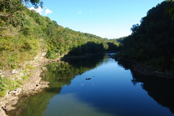
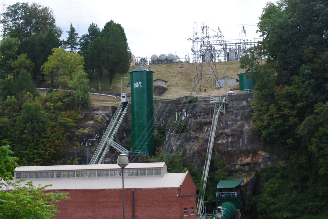
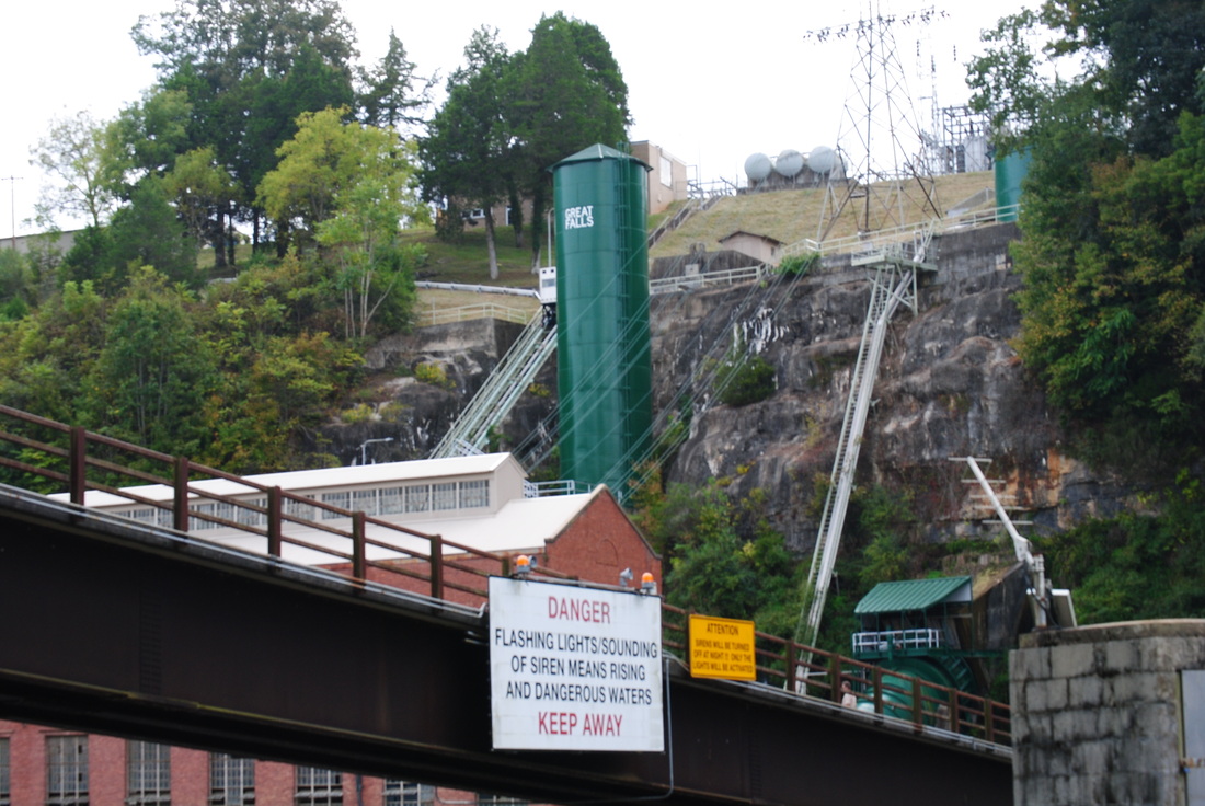
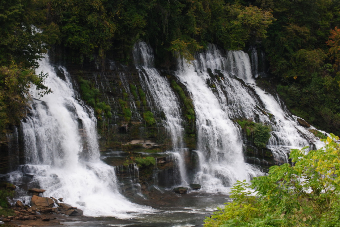
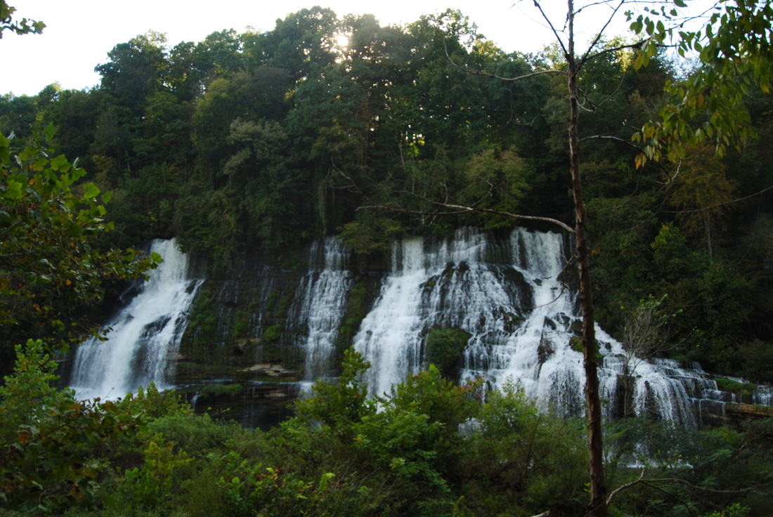
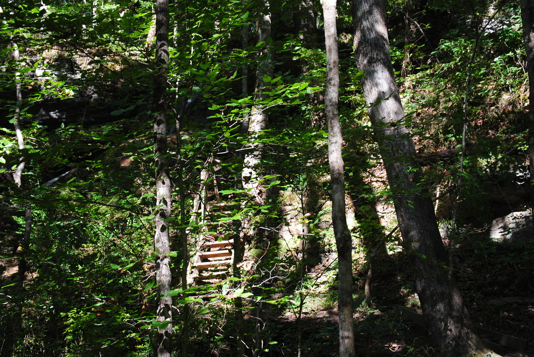
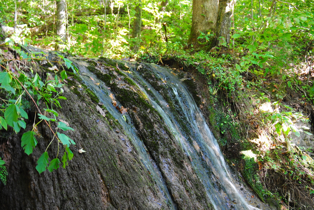
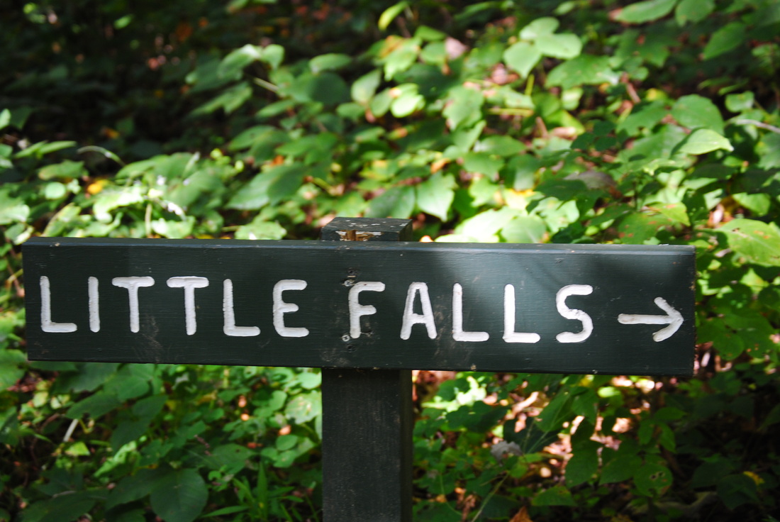
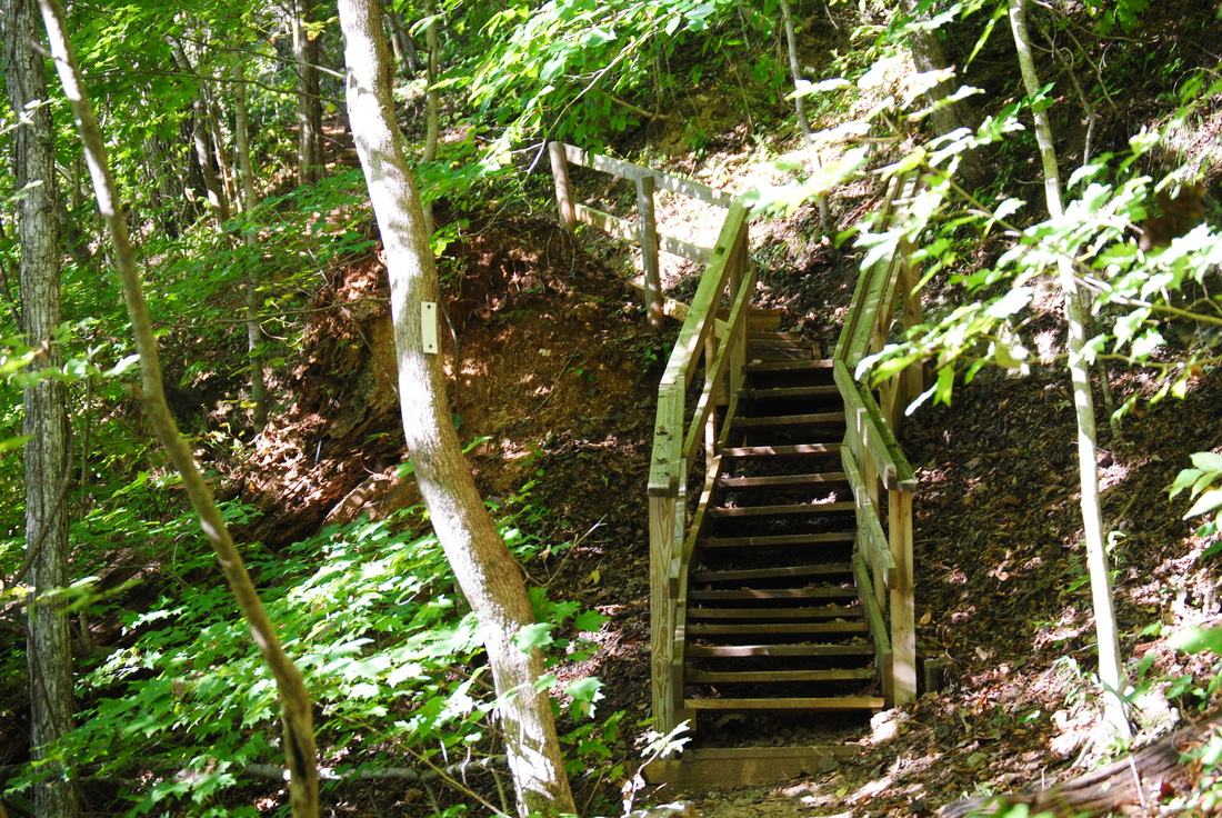
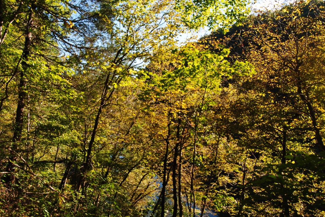
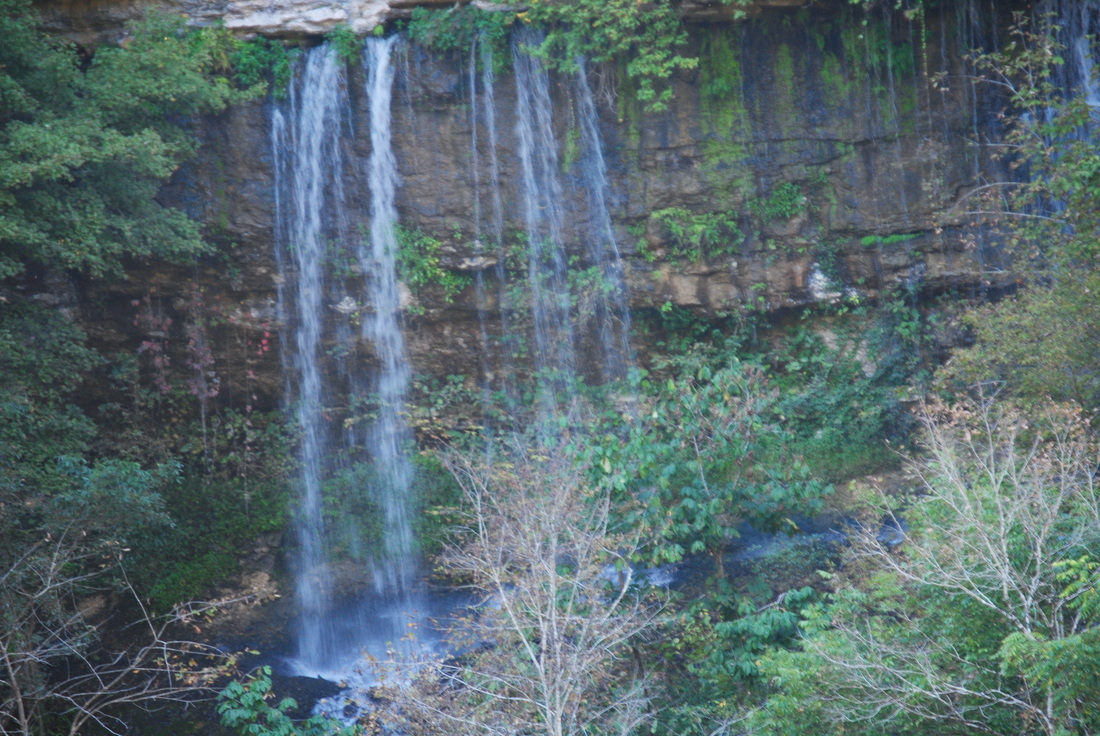
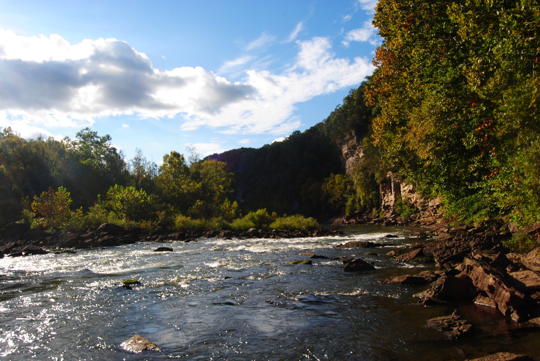
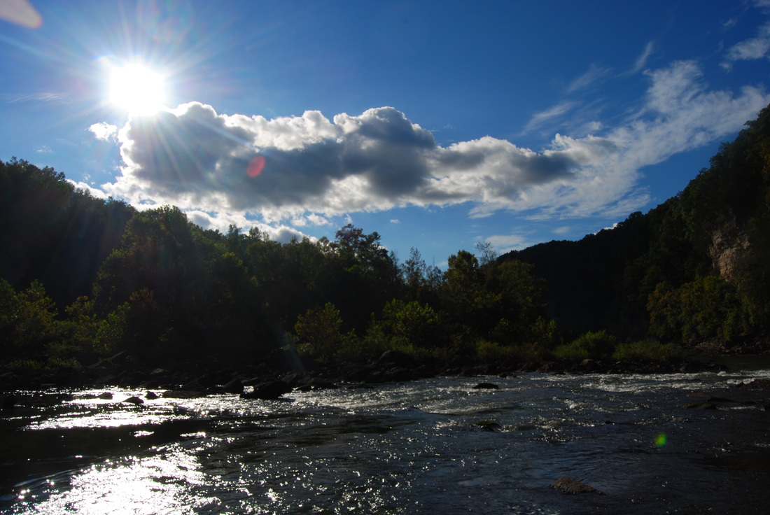
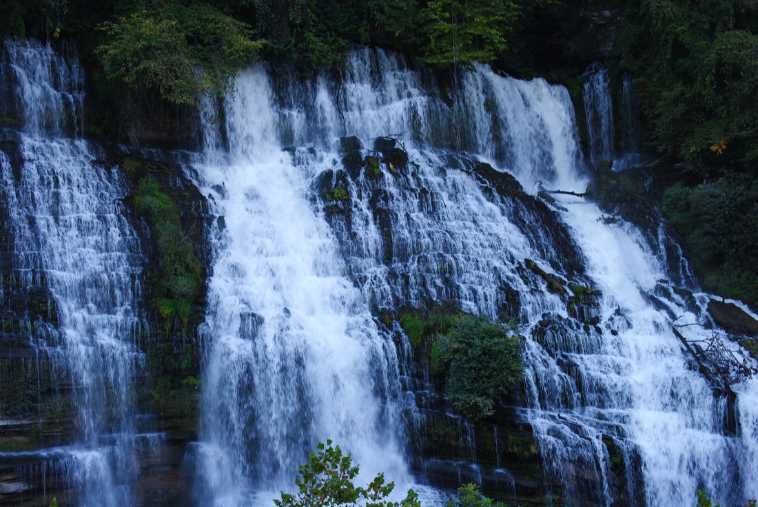
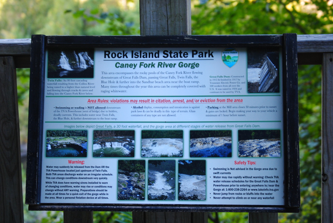
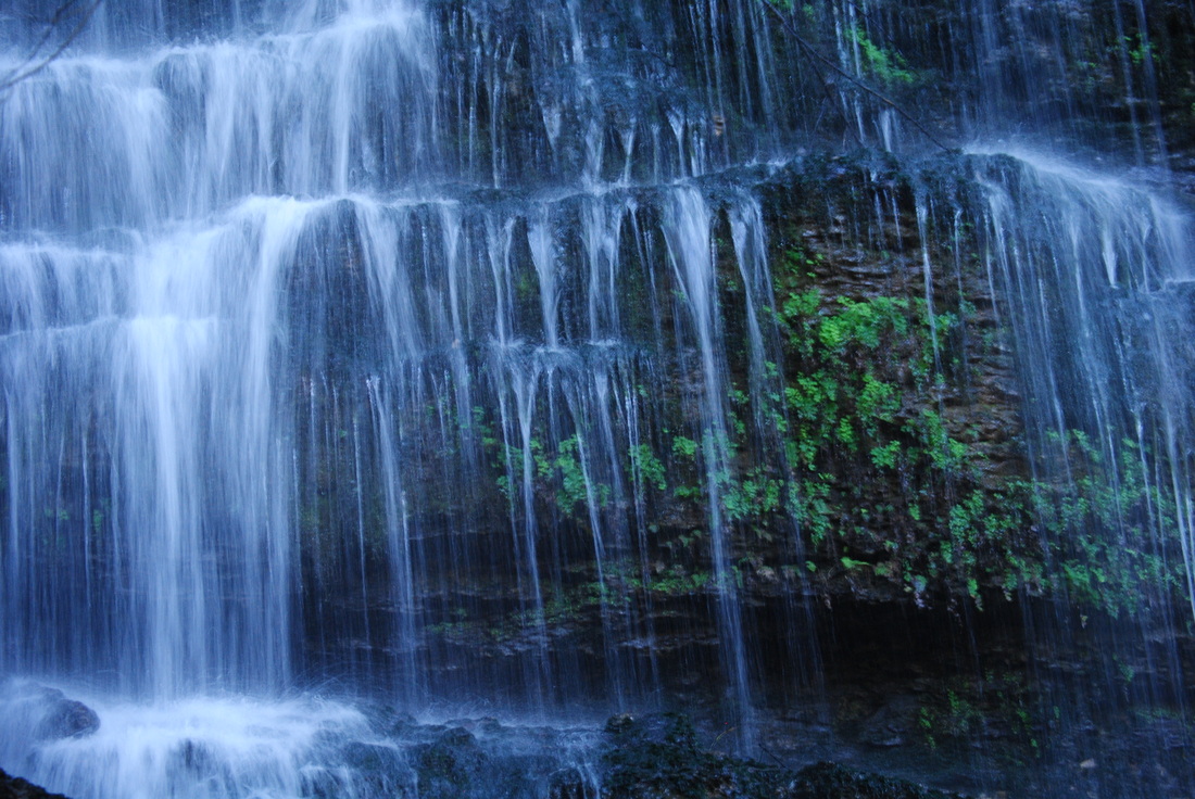
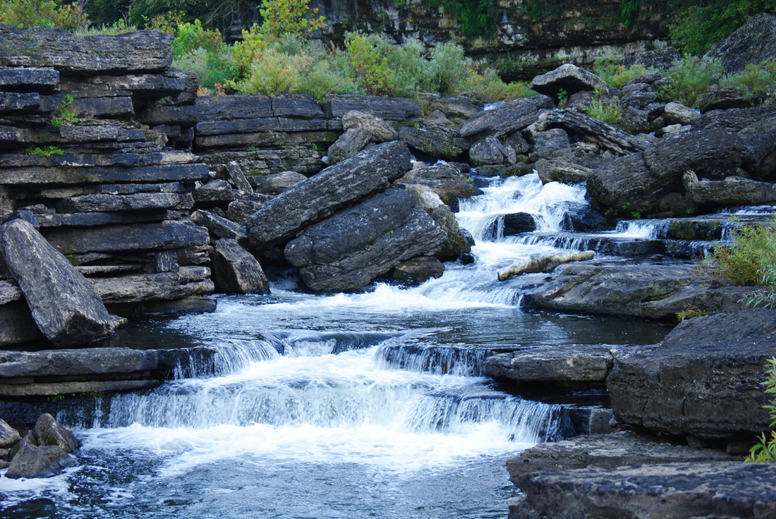
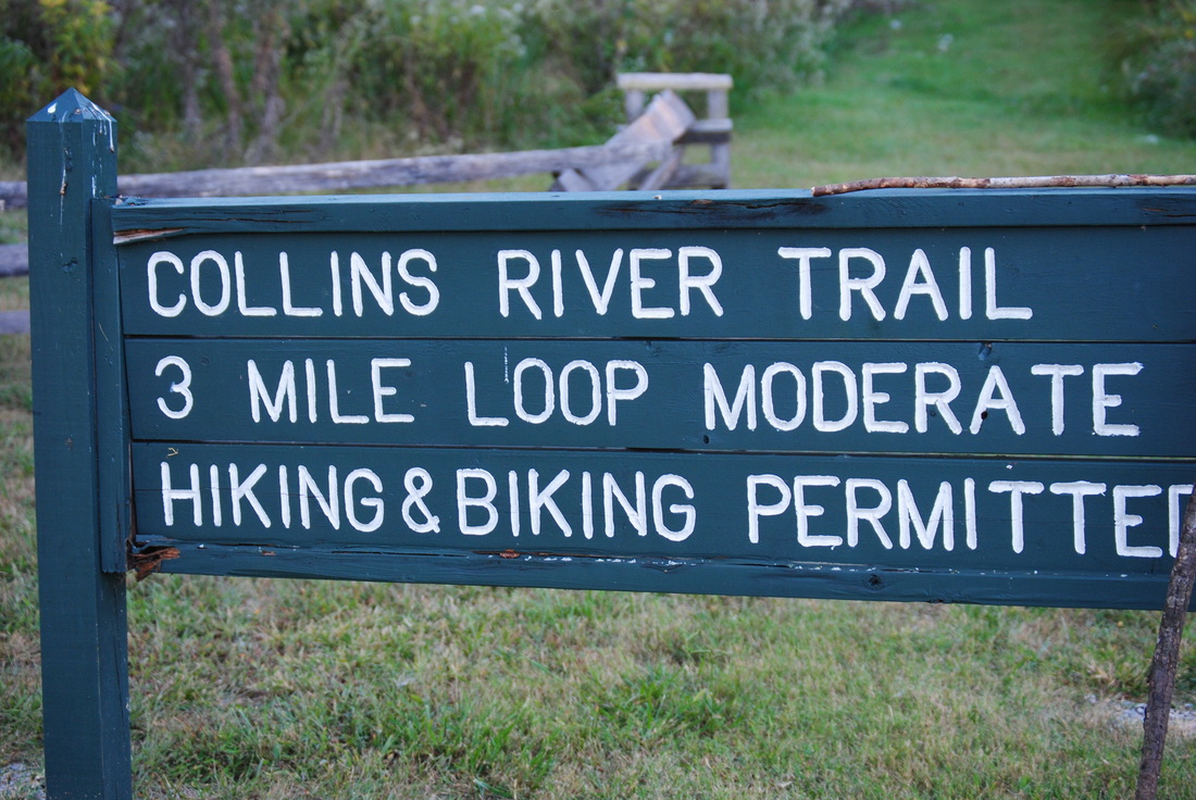
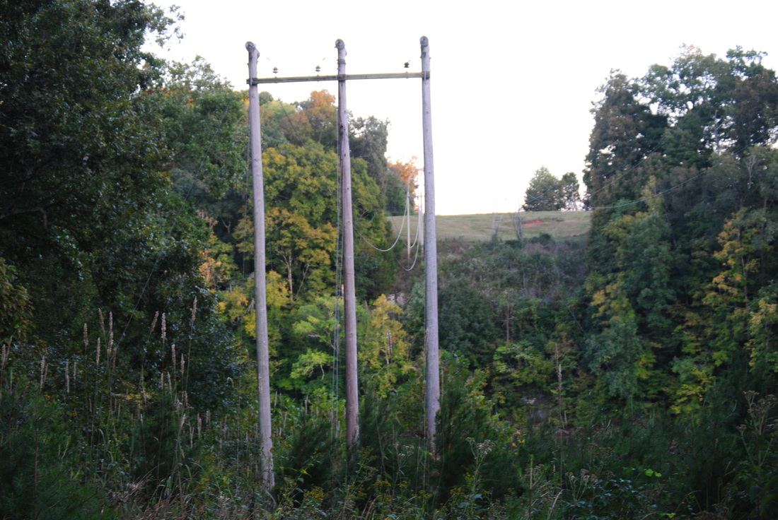
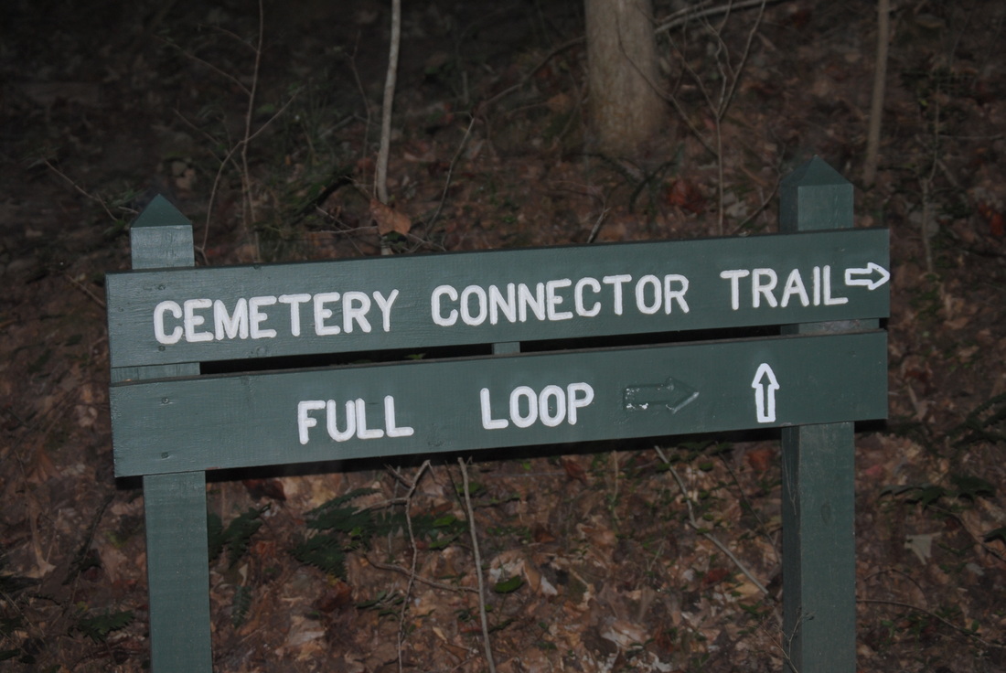
The Caney Fork River starts off in the Cumberland Mountains of Northern Tennessee. On its way to the Cumberland River and eventually Tennessee River, it passes through Scotts Gulf, as you might know, if you have followed this blog for a bit. I have hiked in Scotts Gulf before. Leaving Scotts Gulf, the Caney Fork widens on its way to Nashville. Rock Island State Park protects a rugged gorge in an otherwise mostly flat area. Here, the Rocky River flows into the Collins River, right before the Collins River flows into the lake-like Caney Fork River. Further downstream, you'll find a powerhouse and Great Falls Dam - the source of the lake. However, perhaps the biggest beauty of the park is a unique, one of a kind waterfall. Twin Falls flows out of a cave system, and drops into the Caney Fork. This hike occurred on Saturday, September 25th, 2014. My plan was to hike a few trails across the park, encompassing the best features. Each trail is listed below with a small description. 

Directions: From McMinville, TN to the junction of TN State Route 136 and TN State Route 287 (The center point for hikes at Rock Island State Park): Follow US Highway 70S East to TN State Route 136. Here, turn left onto TN State Route 136 and follow it for 1.7 miles until the junction with TN State Route 287. For directions to each trailhead from this point, follow directions further below in this post.
1st Trail: Downstream Gorge Trail
R/T Length of Trail: 1.7 Miles
Duration of Hike: 1 Hour, 15 Minutes
Type of Hike: Lollipop 
Difficulty Rating: 3 out of 10
Pros: Numerous water features; generally very scenic
Cons: None
Water Features: Twin Falls - 10 stars; Little Falls - 3 stars
Scenic Views: None
Best Season(s) to Hike: Autumn
Trail Blaze Color(s): Downstream Gorge Trail - White; Spur Trails - Blue
Beginning Point: Parking area at the end of Powerhouse Road
Directions: From the junction of HWY-136 and HWY-287: Follow HWY-136 north for 1.2 miles. Right after crossing the Caney Fork River on a bridge, turn left onto Powerhouse Road. Follow Powerhouse Road for 2.2 miles until two parking areas on the right - one large and a smaller one. 
This is probably the most beautiful trail in the park, so if you're going for a trip to the park,  make sure to do this one. That's why I am putting it first. 


This hike begins at the gravel parking area on Powerhouse Road. Take the trail at the far end of the parking. For the first 0.1 mile, it goes steeply downhill to the river. Twin Falls is directly in front of you, and there are several vantage points - both to the left and to the right. My favorite one was on the left. Twin Falls is an amazing waterfall. It is 80 feet high and 200 feet wide.As deceptive as it is, this waterfall didn't exist here all the time. Apparently, there was an unknown cave system here, and when Great Falls Dam was built, the cave system opened up and water started seeping out of it. Originally, Twin Falls was two separate waterfalls, but gradually, the hole became so large that it became one big waterfall coming out of nowhere. I have never seen a waterfall like this before. It is truly unique. 


From Twin Falls, keep following the Downstream Gorge Trail's white blazes westward. Around 0.2 miles, a spur trail to Little Falls heads right. the spur is only 100 yards long, and leads to an interesting "little" waterfall, hence the name. This is actually a small creek that spills acutely down a rock overhang, more like a slide waterfall. However, you can actually walk under this overhang without getting wet, because it is a small cave. On the other side of the cave you get the best view of Little Falls. Retrace your steps to the main trail, and keep going forward on it. Next, there will be three crossings of the branches of the "Little Falls Creek". Each one can be rock hopped. After this, the gorge becomes even more rugged and steep, so the trail ascended some steps and started to follow the steep gorge walls. At one of the staircases, look closely across the gorge - if you have a binocular or zoom lens n your camera, you can see another waterfall coming out of nowhere, out of a hole in the rocks. I am not aware of a name of that waterfall. At 0.5 miles, reach the loop part of the trail. Here, there is an excellent view of the Caney Fork Gorge. The header to this post was taken at this place. It doesn't mater which way to do the loop, but I did it clockwise, so turn left. The trail will be just above the  river for some time, and then, at 0.8 miles, there will be a spur trail to the left that leads to the Blue Hole. This spur trail is only 100 yards, so take it. It leads onto a small beach at the river. This is a beautiful spot, with an amazing view of the surrounding ruggedness. 


Once you have taken in the beauty of the surroundings, retrace your steps to the loop, and keep following it. There will be a brief ascent and then descent ending at the loop junction at 1 mile. Retrace your steps to Twin Falls. For the sake of a difference, instead of taking the route left, go forward past Twin Falls to the powerhouse. The powerhouse is quite a view! Then, ascend the long stairway to the lower parking area, and walk the road back to the original parking. 
2nd Trail: Old Mill Access Trail
R/T Length of Trail: 1 Mile
Duration of Hike: 30 Minutes
Type of Hike: Out-and-back
Difficulty Rating: 3 out of 10

Pros: More waterfalls
Cons: Lots of rocks
Water Features: Great Falls - 5 stars; Unnamed falls on Old Mill Access Trail - 4 stars
Scenic Views: None
Best Season(s) to Hike: Year-round
Trail Blaze Color(s): Old Mill Access Trail - White; Unnamed Falls Spur - Blue
Beginning Point: Old Mill Parking Area
Directions: From the junction of HWY-136 and HWY-287: Turn left and follow HWY-287 for 1.3 miles. The Old Mill Parking Area will be on the right after an old mill. 
The Old Mill Access Trail is nothing much more than, just that, an access. For its first 0.3 miles, it steeply descends down wet, stone steps. They are always wet from all the seeps on the cliffs. At 0.3 miles, the steps end at a tiny spur to a pretty waterfall. It's a small stream that spills over the cliff, but during high water, it can look pretty good. Here, turn right, cross the stream, and proceed through the brush to reach the Caney Fork at 0.4 miles. Then, go a bit downstream and find a place to descend down to water to see Great Falls. It is a pretty nice cascade , as it travels through a narrow passageway. It looks especially beautiful in high water. Also, I have no idea why this trail is rated strenuous. It would get a difficulty rating of 1 if not for all the wet steps and rocks. However, this is the only good access to Great Falls, which is worth seeing, if you're in the park. 
3rd Trail: Collins River Trail 
R/T Length of Trail: 3 Miles
Duration of Hike: 1 Hour
Type of Hike: Loop
Difficulty Rating: 1 out of 10
Pros: Easy; Views of Collins River
Cons: None
Water Features: None
Scenic Views: None 
Trail Blaze Color(s): White
Best Season(s) to Hike: Year-round
Beginning Point: Small, gravel parking area under powerlines on TN-287
Directions: From the junction of HWY-136 and HWY-287: Turn left and follow HWY-287 for 1.7 miles. As you reach the powerlines and a sign, "Great Falls Dam", watch for a small parking area on the left. This is the trailhead. 
The Collins River Trail is generally one of the easiest trails I have done in a long time. Typical to a state park, the trail follows a flat surface on the southeastern end of a peninsula separating the Collins and the Caney Fork. The first mile of the trail stays above the river, with some good views of it through trees. At 1 mile, there is a junction with a Connector Trail that cuts the mileage to 2 miles and passes by an old cemetery. Around this time, you pass under powerlines. At 1.5 miles, pass under powerlines again, and make a gradual turn north, getting closer to the Collins River. There is a bench here to sit and view the water. At 2 miles, the trail makes a sharp turn left. The HWY-287 bridge over Collins River is visible on the right. The trail ascends a bit and then parallels the road to reach a junction with the Connector Trail at 2.4 miles. The rest of the trail is more gentle ascent, although pretty much nothing. The trail tops out on the grassy hill where the powerlines cut through at 3 miles. The parking area is just down the hill. 


In summary, Rock Island State Park has some very nice scenery, and is certainly worth visiting. There's a few trails for excursion too. However, I would not return a second time. I have pretty much seen most of the park's attractions. Below are my pictures and videos. 
1 Comment
Mary Patricia Macy link
2/3/2023 09:08:27 am

Any trails suitable for a person using a walker?

Reply


Leave a Reply.

    About Me

    Mark Oleg Ozboyd
    I'm an avid outdoor explorer and a hobbyist landscape photographer. I'm 21 years old and have been hiking since 2011. Originally based out of Atlanta, Georgia, I started out by occasionally hiking short trails throughout well-known Georgia State Parks. During 2012 and 2013, I began to expand my trips into adjacent states, as well as into the wilder National Forest areas rather than just State Parks. Throughout the years that followed, as I slowly ran out of popular hiking trails in my area, I began to search for and hike in more seldom-visited areas. Today, you can find me out in the woods every weekend, whether it's on an official trail or bushwhacking through cross-country terrain without any paths. I now attend Washington & Lee University and am exploring Virginia and West Virginia. My other hobbies include chess, science, old music, and meteorology. I have 3 years of amateur weather forecasting experience, having studied a lot of meteorology basics over the years. I am also a student at European School of Music where I learned that music and nature have a lot in common. Listening to good music inspires me to capture nature's beauty on the camera in different aspects that also make me recall many beautiful music pieces that I've heard.​


    Dear readers: I have invested a tremendous amount of time and effort in this website and the Georgia Waterfalls Database the past five years. All of the work that has gone in keeping these websites updated with my latest trip reports has almost been like a full-time job. This has not allowed me to pick up a paid job to save up money for college, and therefore, I I've had to take out loans. If you find the information on this website interesting, helpful, or time-saving, you can say "thanks" and help me out by clicking the button above and making a contribution. I will be very grateful for any amount of support you give, as all of it will apply toward my college tuition. Thank you! 

    Enter your email address to subscribe for trail reports:

    Delivered by FeedBurner


    Picture
    Coming in 2022-2023?

    Other Hiking Websites

    DWHike's Adventures
    Florida's Natural Wonders
    Florida Trailblazer
    Meanderthals
    Mountain Images
    by Bernie Boyer

    North Carolina Waterfalls with
    ​Kevin Adams
    Take-a-Hike!
    Tennessee Landforms
    Waterfall Page
    Waterfall Adventurer
    Zach's Mild Adventures

    Miles Hiked

    Year 1: 540.0 Miles
    Year 2: 552.3 Miles
    ​Year 3: 518.4 Miles
    Year 4: 482.4 Miles
    Year 5: 259.9 Miles

    Archives

    March 2021
    February 2021
    January 2021
    November 2019
    October 2019
    September 2019
    August 2019
    July 2019
    June 2019
    February 2019
    January 2019
    December 2018
    November 2018
    October 2018
    August 2018
    July 2018
    June 2018
    May 2018
    April 2018
    March 2018
    February 2018
    January 2018
    December 2017
    November 2017
    October 2017
    September 2017
    August 2017
    July 2017
    June 2017
    May 2017
    April 2017
    March 2017
    February 2017
    January 2017
    December 2016
    November 2016
    October 2016
    September 2016
    August 2016
    June 2016
    May 2016
    April 2016
    March 2016
    January 2016
    December 2015
    November 2015
    October 2015
    September 2015
    August 2015
    July 2015
    June 2015
    May 2015
    April 2015
    March 2015
    February 2015
    January 2015
    December 2014
    November 2014
    October 2014
    September 2014
    August 2014
    July 2014
    June 2014
    May 2014
    April 2014
    March 2014
    February 2014

    Categories

    All
    Adel
    Adirondack Park
    Alabama
    Alfred A. Ring Park
    Allegheny Trail
    Amicalola Falls State Park
    Anniston Area
    Apalachicola Bluffs And Ravines Preserve
    Apalachicola National Forest
    Apalachicola/Port St. Joe Area
    Apopka
    Appalachian Trail
    Appling
    Art Loeb Trail
    Aska Trail System
    Bakersville
    Balm-Boyette Scrub Preserve
    Balsam Lake Recreation Area
    Bankhead National Forest
    Bartow County Parks
    Bartram Trail
    Basinger
    Beersheba Springs
    Benton
    Benton Mackaye Trail
    Berry College Trail System
    Best Hike
    Big South Fork National Recreation Area
    Black Bear Wilderness
    Black Rock Mountain State Park
    Blairsville
    Blakely
    Blood Mountain Wilderness
    Blowing Rock
    Blue Ridge
    Blue Ridge Parkway
    Boone
    Bradenton
    Bradenton Beach
    Brasstown Bald
    Brasstown Wilderness
    Brevard
    Bryson City
    Buchanan
    Bucks Pocket State Park
    Bulow Creek State Park
    Bulow Plantation Ruins State Park
    Caesars Head State Park
    Caladesi Island State Park
    Calhoun
    Camel's Hump State Park
    Cashiers
    Caspersen Beach Park
    Catfish Creek State Park
    Caves
    CC Putnam State Forest
    Cedar Point Environmental Park
    Chatsworth
    Chattahoochee National Forest
    Chattanooga
    Chattanooga Valley
    Chattooga National Wild And Scenic River
    Cheaha Wilderness
    Cherohala Skyway
    Cherokee
    Cherokee National Forest
    Chiefland Area
    Chillhowee Recreation Area
    Chipley
    Chunky Gal Trail
    Circle B Bar Reserve
    Citico Creek Wilderness
    Citrus Wildlife Management Area
    Clarkesville
    Clayton
    Cleevland
    Cleveland
    Cloudland Canyon State Park
    Cohutta Wilderness
    Collier-Seminole State Park
    Cordele
    Cornelia
    Covington
    Crestview Area
    Crew-land-and-water-trust
    Cullowhee
    Cumberland Trail
    Dahlonega
    Dalton
    Dawson Forest Wildlife Management Area
    Dawsonville
    Dayton
    De Soto National Memorial
    DeSoto State Park
    Dillard
    Double Springs
    Ducktown
    Duncan Ridge Trail
    Dunlap
    Eagle's Rest Park
    Eastpoint
    Econfina Creek Wildife Management Area
    Eglin Air Force Base
    Elizabethton
    Elkins
    Elk Knob Game Lands
    Elk Park
    Ellicott Rock Wilderness
    Ellijay
    Emerson Point Preserve
    Englewood Area
    Enota Retreat
    Erwin
    Falling Waters State Park
    Fayetteville
    Fires Creek Recreation Area
    Fire Tower
    Flint River
    Florence Area
    Florida
    Florida Caverns State Park
    Florida Trail
    Foothills Trail
    Fort Mountain State Park
    Fort Myers Area
    Fort Payne
    Fort Payne Area
    Fort Yargo State Park
    Franklin
    Franklin Delano Roosevelt State Park
    Franklin-Marion State Forest
    Frozen Head State Park
    Gainesville
    Gainesville Area
    Gatlinburg
    George Washington National Forest
    Georgia
    Georgia Veterans Memorial State Park
    Glasgow
    Gorges State Park
    Grandfather Mountain State Park
    Great Smoky Mountains National Park
    Greeneville
    Green River Game Lands
    Gruetli-Laager
    Grundy Forest State Natural Area
    GTM Reserve
    Guana River Wildlife Management Area
    Hayesville
    Helen
    Hiawassee
    High Falls State Park
    Highlands
    Highlands Scenic Highway
    Hillsborough River State Park
    Hinson Conservation & Recreation Area
    Historic Sites
    Honeymoon Island State Park
    Hot Springs
    Huntington
    Inverness Area
    Jackson
    Jasper
    Jefferson National Forest
    Joan M. Durante Park
    Jonathan Dickinson State Park
    Jones Gap State Park
    Joyce Kilmer Slickrock Wilderness
    Joyce Kilmer - Slickrock Wilderness
    Juniper Prairie Wilderness
    Kelly Park
    Keown Falls Recreation Area
    Kolomoki Mounds State Park
    LaFayette
    Lake City Area
    Lake George Wild Forest
    Lake June-in-Winter State Park
    Lakeland Area
    Lake Placid
    Lake Russell Wildlife Management Area
    Lake Wales Ridge State Forest
    Laurel Fork North Wilderness
    Leffis Key Preserve
    Leon Sinks Geological Area
    Lexington
    Lineville
    Linville
    Linville Gorge Wilderness
    Lithia Springs
    Little Frog Wilderness
    Little Manatee River State Park
    Little River Canyon National Preserve
    Longboat Key
    Long Trail
    Lookout Mountain
    Lookout Mountain Battlefield
    Lovingston
    Lula Lake Land Trust
    Lumpkin
    Maggie Valley
    Manatee Springs State Park
    Marianna Area
    Mark Trail Wilderness
    Marlinton
    Mccaysville
    McMinville
    Mentone
    Middlesex
    Mistletoe State Park
    Monongahela National Forest
    Montreat
    Mountain Bridge Wilderness Area
    Mountain City
    Mountains To Sea Trail
    Mountains-to-Sea Trail
    Mount Rogers National Recreation Area
    Myakka River State Park
    Myron B. Hodge City Park
    Nantahala National Forest
    Naples
    Naples Area
    Natural Bridge State Park
    Neal Preserve
    New Castle
    Newport
    New River Gorge National Park
    New York
    North Carolina
    Ocala Area
    Ocala National Forest
    Ocean-to-Lake Trail
    Oconee State Park
    Oconee Station Historic Site
    Okaloacoochee Slough State Forest
    Oldsmar
    Oneida
    Orlando Area
    Ormond Beach
    Oscar Scherer State Park
    Oxford
    Palatka
    Palmetto Trail
    Panama City Area
    Panthertown Valley
    Parrish
    Paynes Creek Historic State Park
    Peaks Of Otter Recreation Area
    Pigeon Crockford Mountain Wildlife Management Area
    Pigeon-Crockford Mountain Wildlife Management Area
    Pigeon-Crockford Wildlife Management Area
    Pine Mountain
    Pinhoti Trail
    Pinnacle Park
    Pisgah Civitan Park
    Pisgah National Forest
    Pittman Center
    Pond Mountain Wilderness
    Ponds/Lakes
    Prentice Cooper State Forest
    Providence Canyon State Park
    Pumpkintown
    Quick Point Nature Preserve
    Raven Cliffs Wilderness
    Reed Bingham State Park
    Reliance
    Rice Creek Conservation Area
    Riverview Pointe Preserve
    Robbinsville
    Robinson Preserve
    Rock Creek Gorge Scenic Area
    Rock Island State Park
    Rome
    Rosman
    Sale Creek
    Salem
    Salt Springs
    Saluda
    Santa Rosa Beach
    Sarasota
    Sarasota Area
    Savage Gulf State Natural Area
    Scenic Views
    Scottsboro Area
    Sebring Area
    Sewanee
    Sheltowee Trace Trail
    Shining Rock Wilderness
    Signal Mountain
    Sipsey Wilderness
    Sky Valley
    Smithgall Woods State Park
    Snowbird Backcountry Area
    Soddy Daisy
    Soddy-Daisy
    Sopchoppy
    South Carolina
    South Cumberland State Park
    Southeastern Cave Conservancy
    Southern Nantahala Wilderness
    Sparta
    Sprewell Bluff Park
    Spring City
    Spring Hill
    Springs
    Spruce Pine
    Standing Indian Backcountry Area
    St. Augustine
    St. George Island State Park
    St. Joseph Bay State Buffer Preserve
    St. Marks Area
    St. Marks National Wildlife Refuge
    Stone Mountain
    Stone Mountain Park
    Suches
    Sumatra
    Sumter National Forest
    Suwannee River
    Swallow Creek Wildlife Management Area
    Sweetwater Creek State Park
    Sylva
    Talladega National Forest
    Tallahassee Area
    Tallulah Falls
    Tallulah Gorge State Park
    Tampa Bay Area
    Tate City
    Tate's Hell State Forest
    Tea Creek Wildlife Management Area
    Tellico Plains
    Tennessee
    Thomaston
    Toccoa
    Topsail Hill State Park
    Torreya State Park
    Townsend
    Tracy City
    Tray Mountain Wilderness
    Trenton
    Triple Creek Preserve
    Troutdale
    Unaka Mountain Wilderness
    Upper Tampa Bay County Park
    Venice
    Vermont
    Virgin Falls State Natural Area
    Virginia
    Virginia Outdoors Foundation
    Vogel State Park
    Wakulla Springs State Park
    Waleska
    Walhalla
    Wartburg
    Water Features
    Waynesville
    Weedon Island Preserve
    Weeki Wachee Preserve
    Wekiwa Springs State Park
    West Palm Beach Area
    West Virginia
    Whitehall
    White Springs
    Winder
    Withlacoochee State Forest
    Young Harris

    RSS Feed

TRAIL REPORTS

Hikes in Alabama
​Hikes in Florida
Hikes in Georgia
Hikes in North Carolina
Hikes in South Carolina
Hikes in Tennessee
Hikes in Virginia

Hiking Resources

Alabama Resources
​
Florida Resources
Georgia Resources
North Carolina Resources
​South Carolina Resources
​
Tennessee Resources

Other

Contact
Map of Hikes
Alphabetical List of Hikes
Southeast Nature Society
© COPYRIGHT 2014-2024
​ALL RIGHTS RESERVED.
Important: I disclaim any responsibility for any damage or personal injury that may occur as a result of the activities and information found on this website. All outdoor activities, especially off-trail hiking, are done at your own risk. Never hike or head into that area that may be above your fitness or experience level.
  • Home
  • Trail Reports
    • Best Hikes
    • Hikes with Scenic Views
    • Hikes with Water Features
    • Alabama
    • Georgia
    • Florida
    • North Carolina
    • South Carolina
    • Tennessee
    • Vermont
    • Virginia
  • Map
  • Hike List
  • Testimonials
  • Resources
  • Contact Us
  • Southeast Nature Society
    • Our Team
  • Georgia Waterfalls Database