
The Fall Creek watershed feeding into the Chattooga River in Oconee County, South Carolina, houses a trifecta of attractive yet lesser-known waterfalls that make for a wonderful half-day trip to access. Andrew Ramey Falls, a 30-foot cascading drop, is just a few hundred feet from Fall Creek Road down an obscure scramble path. The little-hiked pathway becomes more intimate and faint following Andrew Ramey Falls, but it stays easy enough to follow - if one pays attention - all the way to the spectacular sights at Pristine Falls and Falls Creek Falls. If you have the extra energy, you have the extra option of continuing an extra one-tenth of a mile down to the Chattooga River for a refreshing swim. Furthermore, solitude is essentially guaranteed on this trek! This hike occurred on Saturday, September 29th, 2018. My plan was to hike out and back to Andrew Ramey Falls, Pristine Falls, and Falls Creek Falls.
Summary
R/T Length of Trail: 3.2 Miles
Duration of Hike: 2:00 plus 1 hour and 45 minutes of stopping and photography Type of Hike: Out and Back Difficulty Rating: 5 out of 10 Total Elevation Gain: 519 Feet Pros: Gorgeous, secluded waterfalls Cons: Path can be a bit hard to discern at times Points of Interest: Andrew Ramey Falls - 6 stars; Pristine Falls - 8 stars; Fall Creek Falls - 9 stars Trail Blaze Colors: None - not an official trail Best Seasons to Hike: Winter; Spring Fees: None Beginning Point: Faint path just past Fall Creek culvert on Fall Creek Road (FS 722). Directions from Walhalla, SC: From the intersection of Main Street (SC 28) and South College Street (SC 183 South) in downtown Walhalla, follow SC 28 North for 10.6 miles. In the community of Mountain Rest, turn left onto Chattooga Ridge Road. Continue another 7.3 miles, and then, turn right onto Fall Creek Road. Turn left in 0.3 miles to stay on Fall Creek Road, which turns into unpaved FS 722. In another 0.5 miles, arrive at the Fall Creek culvert. There is a small pullout on the left with space for two to three cars just beyond the culvert. There is also a larger pullout before the culvert. Map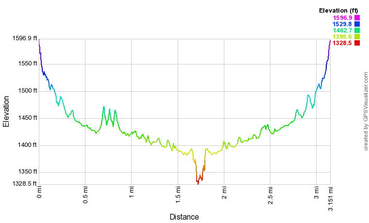
Click the link below to download a .GPX file with a track of this hike.
Details
Despite Oconee County being South Carolina's capital of waterfalls, housing several hundred noteworthy cascades, my travels had rarely taken me to this area and I had hardly made a dent in the regions most beautiful yet lesser-known waterfalls. Thus, on this day, I was excited to knock out the trifecta of seldom-photographed waterfalls in the Fall Creek watershed and round off the evening by later heading to Opposum Creek Falls, which will be described in another trip report.
Start off the hike by looking for the obscure path on the immediate north side of the North Fork Fall Creek culvert. At the time of my hike, the path was oddly blocked by a large pile of small branches and deadfall, making it extra tricky to find. Once you're actually on the path, however, you will find it descending along a very obvious worn track directly alongside the North Fork of Fall Creek. The path first comes out a set of scenic cascades immediately above Andrew Ramey Falls. Bear right slightly and continue the steep descent into the valley. At about 200 feet from the road, look for another path splitting off to the left and descending 50 feet to creek-level and the base of Andrew Ramey Falls (GPS: N34° 49.362' W83° 15.089'). Be sure to make this quick side trip before continuing on down to Pristine Falls and Fall Creek Falls! Andrew Ramey Falls is a picturesque 30-foot sheer drop that forms a set of delicate cascades over the stairstep rock ledge. The shallow pool in front - perfect for wading - is strewn with colorful pebbles. This waterfall doesn't frequently receive high marks from people who have seen Pristine Falls and Fall Creek Falls, but I encourage you to think otherwise, as I really like this waterfall. Past Andrew Ramey Falls, the path becomes a bit fainter as it descends through a rhododendron jungle near North Fork Fall Creek. You will shortly pass a couple of small cascading waterfalls, sometimes called Midway Falls and Rhodo Falls respectively. After crossing a small tributary, the path reaches the flatter bottomlands along Fall Creek around 0.3 mile and becomes very overgrown with dog hobble. Even though the path is discernible, you will definitely need to keep a close eye as you are pushing through the vegetation. 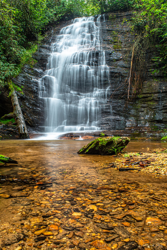
30-foot Andrew Ramey Falls is a very picturesque cascade that hikers get treated to at the start of the Fall Creek trek.
At 0.6 miles, reach a junction with another faint path that leaves left and heads toward Pristine Falls. It is important to recognize this junction if you wish to see Pristine Falls. The intersection is located almost directly across from the confluence of North Fork Fall Creek and Fall Creek. Turning on the Pristine Falls path, you will instantly come to a shallow ford of North Fork Fall Creek. The water is only ankle-deep; it may even be possible to rock hop in times of lower water, but the waterfalls will not be as dynamic in those conditions. On the other side, walk about 100 feet through an open flat before picking up the trail along an old logging road that moderately ascends the ridge on the north side of Fall Creek. One-tenth of a mile from the Fall Creek path, at 0.7 miles, look for a narrow but well-worth leaving the main logging road at an angle to the right. This is the path to Pristine Falls. The path meanders along the slope for a bit before dropping to Fall Creek in the form of a muddy scramble. You can see Pristine Falls from here, but for the best views, rock hop and wade 200 feet upstream, reaching the base of Pristine Falls at 0.8 miles.
Pristine Falls (GPS: N34° 49.313' W83° 15.388') is a powerful, complex waterfall in a secluded grotto. The waterfall starts out as a steep slide/sheer drop before transforming into a curtain-like free-fall. Although the total height is over 50 feet, you can only see the waterfall's most impressive 25-30 feet when standing at the base. I also really like the more distant view of the waterfall from downstream, because it highlights the conglomerate of jagged, mossy boulders lying immediately below the waterfall's small sandy pool. Pristine Falls was christened and discovered by Christopher Cockfield on Google Earth. I know I speak on the behalf of the whole waterfalling community when I saw that we are thankful for the discovery of such a spectacular, hidden waterfall so close to the main trail to Falls Creek Falls, adding even more allure to this backwoods trek! Retrace your steps to the main trail, returning to the Fall Creek Falls Path at 1.0 mile. Resume following the trail downstream along the now-larger Fall Creek, which stays quite placid along its sandy course. At 1.05 miles, pass the remains of a chimney at an old homesite to the left (this is a good landmark to determine whether or not you have passed the Pristine Falls junction). The trail alternates between travelling a bit higher on the hillside and immediately alongside the creek, and it continues to be a little overgrown in the flats near the creek. Reach a particularly confusing area around 1.35 miles, where the trail seems to dead-end at an old campsite. The trail actually bears right through a muddy area and then uncomfortably traces the very edge of Fall Creek. 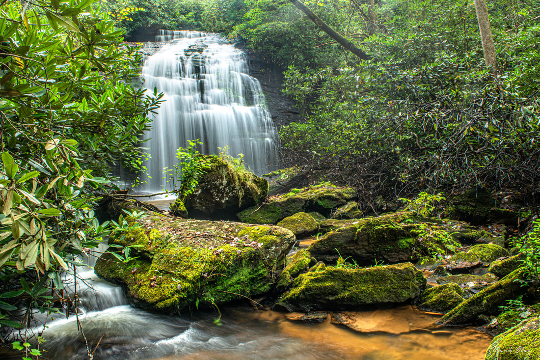
Pristine Falls is a spectacular, powerful waterfall located one-tenth of a mile off the main path to Fall Creek Falls.
Finally, at 1.65 miles, the path approaches the top of Fall Creek Falls. The flat rock slabs at the top of the falls are relatively safe to walk out on, but as always, be sure you stay away from the waterfall's dangerous edge! The main path curves right and makes a broad arc away from the waterfall on its north side, tracing the base of a cliff line. Avoid the temptation of scrambling down to the waterfall too quickly, and simply keep following the path downstream. You will soon arrive at a spot that appears like a switchback. While a very faint path continues ahead to the Chattooga Rive, you must turn sharply left to access the base of Fall Creek Falls, which you'll reach at 1.75 miles (GPS: N34° 49.133' W83° 15.992').
Fall Creek Falls is a stunning finale to this hike, for its structure is exquisite! I love how this 40-foot waterfall drops over the sheer ledge at the top, hits a small flat outcrop, and drops of another equally sheer drop before consolidating into the gentle slide to the sandy pool at the bottom. A portion of the waterfall is free-falling, adding further character. It was also beautiful to observe the lush moss growing behind the delicate curtains of water flowing down the sheer ledges. The pool is full of subtle patterns in the sand, constantly being crafted by the gentle flow of water. At Fall Creek Falls, you have the option of continuing along Fall Creek downstream to its confluence with the Chattooga River, which lies a little over one-tenth of a mile downstream. Although I did not have time to extend my hike there, I know that you get to see one more small, cascading waterfall right where the creek reaches the Chattooga, and the mighty Chattooga is a sight all in itself. The primary drawback of continuing to the Chattooga is that the path is almost non-existent and not much better a bushwhack beyond Fall Creek Falls, though chances are you would have no problem navigating it if you have already gotten this far. At any rate, if you simply choose to retrace your steps from Fall Creek Falls, you will return to your vehicle at 3.2 miles, concluding the hike. Even though the entire hike back to Fall Creek Road is at an easy to moderate uphill grade, it never feels difficult except the final quarter-mile near Andrew Ramey Falls, and besides, you will be feeling much more refreshed by now from having seen these beautiful water features. Be sure to keep a close eye on the faint path and not deviate anywhere on your return trip! Mileage
0.0 - Fall Creek Road
0.05 - Andrew Ramey Falls 0.6 - Pristine Falls Trail Jct 0.8 - Pristine Falls 1.0 - Back on Main Trail 1.05 - Old Homesite 1.75 - Fall Creek Falls 3.2 - Fall Creek Road Videos
1 Comment
Angela
6/30/2021 01:53:42 pm
I visited this location in 2018 after Reedy Branch Falls on a raining day. After finding the trail entrance, I hiked down steep trail and scramble to the falls, standing in front of it in the rain. According to your webiste, the falls where I was is Andrew Leave a Reply. |
About MeMark Oleg Ozboyd Dear readers: I have invested a tremendous amount of time and effort in this website and the Georgia Waterfalls Database the past five years. All of the work that has gone in keeping these websites updated with my latest trip reports has almost been like a full-time job. This has not allowed me to pick up a paid job to save up money for college, and therefore, I I've had to take out loans. If you find the information on this website interesting, helpful, or time-saving, you can say "thanks" and help me out by clicking the button above and making a contribution. I will be very grateful for any amount of support you give, as all of it will apply toward my college tuition. Thank you!

Coming in 2022-2023?
Other Hiking WebsitesMiles HikedYear 1: 540.0 Miles
Year 2: 552.3 Miles Year 3: 518.4 Miles Year 4: 482.4 Miles Year 5: 259.9 Miles Archives
March 2021
Categories
All
|
||
 RSS Feed