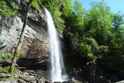
 The Cumberland Trail is a beautiful trail. While it is not fully completed yet, each of its sections is quite beautiful, and I enjoy each of my hikes along the trail. The Cumberland Trail follows the Cumberland Plateau in Central Tennessee, and it has both waterfalls and scenic views. The unique geography of the Cumberland Plateau always makes the hikes interesting. There are dozens of small but steep gorges, and there's rocks everywhere. This hike occured on Saturday, May 3rd, 2014. My plan was to hike a portion of the Cumberland Trail in the Laurel-Snow Pocket Wilderness. I planned visiting Laurel Falls and Bryan Overlook, and then go up the opposite side of the gorge to Buzzard Point Overlook. While there were a couple unexpected things throughout the hike, my plan got fulfilled. R/T Length of Trail: 10.5 Miles Duration of Hike: 6 Hours Type of Hike: Out and back with Y-shape designation Difficulty Rating: 6 out of 10; moderate, but several strenuous sections, including one steep rock scrambling section; two creek fords Beginning Point: Laurel-Snow Pocket Wilderness Trailhead at the end of Pocket Wilderness Road near Dayton, Tennessee. Directions: From Chattanooga, TN: Follow US-27 North to Dayton. In Dayton, turn left onto TN State Route 30 (3rd Avenue). Drive 0.3 miles, and turn right onto TN State route 30 (Market Street). Drive 0.2 miles, and turn left onto TN State Route 30 (Dayton Mountain Highway). In 0.9 miles, turn right onto Black Valley Road. Follow Black Valley Road for 1.4 miles. When there will be an old church on your right, turn left onto a gravel road (Pocket Wilderness Road). Pass through gates, and follow Pocket Wilderness Road for 1 mile until dead-end at the trailhead parking area. A large waterfall, expansive 240 degree vistas, miles of trails, what could be better? Unfortunately, while this is the perfect environment for hikers like me, don't expect to be alone on this trail. In fact, not even close. The ease of access to Laurel Falls makes this a very popular destination, and at least a third of the people goes further to the overlooks. When I arrived at the trailhead, I found myself in a line of cars! Seems like everybody was waiting for parking spots, and I was getting worried when I saw cars backed up along the shoulder of the last 0.1 miles of the Pocket Wilderness Road. Fortunately, I found an empty parking spot in the parking area, but there was at least 20 cars altogether - maybe over 30. Also, the gates at the beginning of the trailhead road are locked at sunset. It's best to get out before sunset, but if you get out after hours, call the local county police department. Don't let the first mile of the hike lure you into believe that this will be a short afternoon stroll. While this is obviously not in the hardest hikes category, there are some hard sections that will get you panting. The first 1.2 miles of the trail will follow an old railroad. Thus, this part of the hike was quite easy, as the trail was wide and flat. The trail will start off following Richland Creek to its left. Almost right away, the trail will cross a tributary via rock hop. There will be a small bridge over a muddy area as well. Around 0.2 miles from the start, the entrance to the Richland Mine will be on the right. Do not enter, even though it is ungated, as it could be potentially life-threatening, because of flooding and crumbling of the mine. The trail will stay flat, while crossing numerous small streams and two bridges. The terrain of this part of the trail is rocky and rooty, though, so it can be a little slow. About a mile from the start of the hike, the trail abruptly narrowed and became more like a traditional path. At 1.2 miles, the main trail will switchback to the right up the mountain, while forward, an unofficial trail leads to the old Dayton Reservoir in 0.1 miles. You don't have to come there, but I went, and I could see the remnants of the dam. There was a nice small waterfall at the remnants of the dam. Back to the main trail, it started the ascent up the north side of the Richland Creek gorge. During the series of switchbacks up the mountain, DO NOT make shortcuts! It is just a few steps more following the trail, so what is the point? I noticed that blazes were frequent on the trail, so it was hard to lose it. After the several switchbacks, the trail leveled out and even started going downhill a bit as it approached Laurel Creek. And then at 1.7 miles since the start of the hike... surprise! The bridge over Laurel Creek was impassable due to a fallen tree on it. Thus, I had to cross via rock hop. I slipped on one of the rocks, and fell in. No harm done to me, but the camera was half submerged. After this, the camera malfunctioned the rest of the day, so you will see some pictures from my other camera in the gallery below. I know they look bad, but it is the best idea I could get to you of how the hike after Laurel Falls looked like. Right after the crossing, there was a trail junction. The main route of the Cumberland Trail turned left, in the direction of Buzzard Point and Snow Falls, while the Laurel Falls Trail turned right towards Laurel Falls and Bryan Overlook. I opted for the latter first. The trail started off following the banks of Laurel Creek. Soon, there was a small cascade, unofficially known as Lower Laurel Falls. After this, the trail climbed up some rocks and reached an interesting spot. Here, the trail went through a hole in the rocks, where you actually had to crawl through like through a cave opening. After the rocks, the trail continued the ascent of the mountain. There were several switchbacks and some downed trees, but overall, nothing too hard. 0.7 miles from the Laurel Falls Trail junction , the trail reached the spur trail to Laurel Falls on a switchback. I went to the base of the falls, and then scrambled up to its side. According to what I read, Laurel Falls is about 80 feet high. After taking a short break at Laurel Falls, I continued up the Laurel Falls Trail. It temporarily leveled out, but it reached the bluff line of the top of the gorge, so the trail was becoming more rocky. It passed by some large rock cliffs, and then the real climb started. This was probably the hardest part of the trail, and it was very steep! It first went steeply up a hill, and then sharply turned right at a double blaze. Here, there was some steep rock scrambling needed. There were large rocks in the way, and the views were growing as I ascended above the bluff line. Once I reached the top, it was a relief. The climb was very hard. After this, the trail leveled out, and reached a spur trail to Laurel Falls Campsites. It was now 0.2 miles since Laurel Falls. After the campsite, the trail passed through a dense forest, and it was quite flat and easy. However, another surprise was just around the corner. I could hear the sound of water approaching, and it was Laurel Creek. What I didn't know, though, was that I had to wade through. I reached the ford at 0.4 miles from Laurel Falls. I pondered for a second whether to cross or not, but it wasn't long. I did cross the Conasauga River 18 times with water knee-high last week, right? Plus, I already had a bath in Laurel Creek further down. At this crossing, Laurel Creek was about ankle deep here, with a few places halfway to the knee. I crossed, and continued following the trail. It quickly ascended above Laurel Creek, and then followed the flat contours of the plateau. 0.4 miles from the crossing, the trail reached a large campsite area and and overlook. The official trail ended here, although an old road turned left. I am not sure where the old road leads to, but I did not go any further. The views from the overlook encompassed the Richland Creek and Henderson Creek gorge. I could see my second destination on the other side of the gorge. I wish I got a better picture from the overlook, but at least you'll have an idea of how it looks like. After a break at the overlook, I headed back down the Laurel Falls Trail. Back over the creek, back past the campsites, back down the steep rocky descent, back past Laurel Falls, back through the hole in the rocks, and back to the junction with the Cumberland Trail. Seeing that I still had some time left for my hike, I took the Cumberland Trail westward towards Snow Falls. I didn't have time to go all the way to Snow Falls, but I planned going to Buzzard Roost Overlook. The trail almost right away passed a side trail to Henderson Creek campsites. The main creek was now Henderson Creek (it becomes Richland Creek after Laurel Creek falls in). The trail briefly ascended, and then slowly descended, all the while following the base of the mountainside. At 0.4 miles from Laurel Falls Trail, the Cumberland Trail sharply turned right onto a large rock pathway, and then around the corner, it reached a 150-foot long bridge over Henderson Creek. On the other side of the bridge, the Cumberland Trail ended. From here, it wasn't built yet, although it is supposed to follow Henderson Creek another 5 miles to a future trailhead. Meanwhile, the trail from here was the Snow Falls Trail, which I followed. The trail started off by descending down to the river bank. 0.3 miles from the bridge, the trail began a long ascent. There was around a half dozen of long switchbacks as it slowly ascended up the mountainside. The ascent was so gradual that sometimes I was wondering, if I was descending or ascending. Eventually, the trail reached the bluffs, and I was about to think that here would be something like on the Laurel Falls Trail. However, the trail went through a pass between the bluffs, and reached a junction at the top of the ridge. It was now 1.4 miles since the bridge. The main Snow Falls Trail turned right, but in order to get to Buzzard Roost Overlook the quickest way, turn left onto an unmarked side trail. This trail reached a dirt road in 0.1 miles. I'm not entirely sure where the road goes to the right, but I turned left. From here, it was 0.4 miles to the end of the road and Buzzard Roost Overlook. Once I reached the overlook... WOW! There were views of both the Richland Creek and Morgan Creek gorges. In addition, I could see the town of Dayton in the valley ahead of me. I put one bad picture in the gallery below, to give you a good idea of how it looks like from the overlook. In my opinion, the view was even better than from the Bryan Overlook. After taking in the views, I headed back. Don't miss the side trail going off the road. It is located at a small turn in the road. From there, it was down the side trail, down all the switchbacks, back over the bridge, and back to the Laurel Falls Trail. Then it was over Laurel Creek, down more switchbacks, and the hike ended with a mile of nice flat trail. When I arrived at the car, it took me exactly 6 hours to hike the 10.5 miles in the Laurel-Snow Wilderness. In summary, this was another great hike on the Cumberland Plateau. After enjoying this hike so much, I think I will come for even more hiking in this area soon. I recommend for everyone hiking the trail to Laurel Falls. Getting up to Bryan Overlook can be tough, but it is not too hard, so if you have the strength, do it! The hike to Buzzard Roost Overlook is not hard at all, and the rewards are even bigger than at Bryan Overlook, so I highly recommend going there. Below are my pictures, and even a few videos. The last 4 pictures are from my other camera.
3 Comments
Jamie
3/27/2016 10:47:24 pm
This is the best explanation of this trail I have read thus far. Thank you - great pictures!
Mark Oleg
3/27/2016 11:18:19 pm
It's a great hike. Enjoy!
mike aguado
12/10/2020 06:53:09 pm
Nice description. How long would it take for a slow poke to go from parking area to buzzards point?Thanks! Leave a Reply. |
About MeMark Oleg Ozboyd Dear readers: I have invested a tremendous amount of time and effort in this website and the Georgia Waterfalls Database the past five years. All of the work that has gone in keeping these websites updated with my latest trip reports has almost been like a full-time job. This has not allowed me to pick up a paid job to save up money for college, and therefore, I I've had to take out loans. If you find the information on this website interesting, helpful, or time-saving, you can say "thanks" and help me out by clicking the button above and making a contribution. I will be very grateful for any amount of support you give, as all of it will apply toward my college tuition. Thank you!

Coming in 2022-2023?
Other Hiking WebsitesMiles HikedYear 1: 540.0 Miles
Year 2: 552.3 Miles Year 3: 518.4 Miles Year 4: 482.4 Miles Year 5: 259.9 Miles Archives
March 2021
Categories
All
|
 RSS Feed