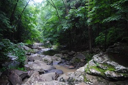
 The Cumberland Trail. It's a beautiful trail, and the more I hike it, the more I like it. The Cumberland Plateau is the southern section of the Appalachian Plateau, and it covers Eastern Kentucky, Central Tennessee, portions of Northeast/Central Alabama, and a small portion of Northwest Georgia. The Plateau is littered with many sandstone outcroppings and bluffs, which in my opinion, give the Cumberland Plateau its characteristics. The Cumberland Trail, when it will be finished, will follow the eastern rim of the plateau known as Walden Ridge throughout Tennessee. The trail begins at Signal Point near Signal Mountain, Tennessee and ends at Cumberland Gap National Historic Park near Cumberland Gap, Kentucky. While many of its sections are under construction or even not planned out, it still provides great section hiking opportunities, and remains one of my personally more favorite long distance hiking trails. While the AT (Appalachian Trail) is much more grand from most hikers' point of view, the lesser traveled CT is in no way less attractive, and in some cases, rivals the AT. This hike occurred on Saturday, June 21st, 2014. My plan was to start at the Cumberland Trail parking pullout on Heiss Mountain Road near TN State Route 111, and to follow the CT through the Blanchard Creek Gorge. Following that, I would ascend to Bare Point, and then descend into the Big Possum Creek Gorge, only to ascend to Perkins Point. From Perkins Point, I would descend into the Little Possum Creek Gorge before reaching Imodium Falls. I would return the same way. R/T Length of Trail: 10.2 Miles Duration of Hike: 6 Hours, 55 Minutes Type of Hike: Out and Back Difficulty Rating: 8 out of 10 Pros: Multiple water features including waterfalls; scenic views; large rock formations; three gorges Cons: Very slow and relatively long trail; lots of rocks; 6 descents and 6 ascents; very few flat areas making rest on the trail almost impossible Beginning Point: Small pullout with space for several cars on Heiss Mountain Road. Directions: From Soddy-Daisy, TN: Follow US-27 North and take the left lanes onto Tennessee State Route 111. Drive around 4 miles until the exit for Jones Gap Road. Take exit ,and ten turn right onto Jones Gap Road. Take the first right onto Heiss Mountain Road. Drive another 0.5 miles on Heiss Mountain Road until you see two signs on the left side of the road: Cumberland Trail State Park and Roadwalk to HWY 111. Park in the small gravel pullout. Demanding. That one word says it all. This hike follows one of the most beautiful sections of the Cumberland Trail, and it is very rewarding, but no matter what, don't discount the hard part of this hike. No! While there's no "extended" ascents like in some of the Blue Ridge Mountains, there is almost no areas to rest on the trail, with over 8 miles out of 10 being ascent or descent. I wasn't quite ready for this but I didn't realize how hard it would be. Anyway, enough with the warnings. When I was on US 27 approaching the trailhead, I had to drive through a classic supercell with pretty good structure. I included a picture of the structure in the gallery below. However, when I turned off onto TN 111, I escaped the main core of the rain. And it even was sunny for the first part of the hike. Key word is "first". More on that later. The parking lot is a small pullout on Heiss Mountain Road with space for several cars. Go the direction where it says Cumberland Trail State Park. The trail reaches a kiosk right away with information about this section of the CT. The downhill steepens after this. Right off the bat, there will be a flight of stone steps and a switchback through a gap between two boulders. 0.1 miles from the start, the trail crossed over one of the branches of Blanchard Creek on a footbridge. A steady descent continued. The trail crossed a field, which appears to be an overgrown very old road. At 0.7 miles the trail reached a small bridge over another of the tributaries of Blanchard Creek. Here, the main stream had a nice cascade. One of the branches of Blanchard Creek is acidic from strip mining, and thus, drinking water from it may be harmful to health. After the bridge, the trail curves around Bare Point, and steeply climbs up to it via more switchbacks and steps at 0.9 miles. Sporadic views appear, and I could make out the Big Possum Creek Gorge and Blanchard Creek Gorge. Little Possum Creek Gorge was hidden behind Hughes Ridge. After Bare point, the trail started descending again without any flat section. There were a couple switchbacks followed by innumerable rock steps. At one point, there was a little natural rock bridge on the trail. After another switchback, the trail started following the bluff line, which just kept getting taller and taller. There were some impressive rockhouses too. Afterwards, the trail left the bluff line, and steeply switchbacked through countless rocks and steps. So far, so good. Pretty much nothing but descent yet, except one very short uphill section. At 1.4 miles, the trail reached the Big Possum Creek bridge. This was the turning point of the hike. The bridge has a very good structure, but surprise... there was a fallen tree on the bridge! Fortunately, the bridge was still intact, and all I had to do is just duck under. On the other side of the bridge, the trail got to the ascent right away. The steepest part was in the beginning, as the trail ascended several sets of stone steps. After the first climb, the trail descended slightly into a small "valley" between the main ridge and cliff line and a smaller ridge on the other side, which I had just ascended. the trail shortly reached an old road from the mining days at 1.5 miles. Here, you have to turn right. Shortly, turn left and ascend another steep set of stone steps to the base of the bluff line. The trail follows the bluff line for the next 0.5 miles. Near the end of the bluff line, there were two piles of coal on the side of the trail. Not sure where they originated from. After this, the trail started ascending more steeply. The cliff line came to an end, and there were several switchbacks that led to the top of Hughes Ridge into a pine forest at 2.7 miles. This was about the time when a heavy thunderstorm came in with lots of thunder, lightning, and heavy rain. The views quickly became much more limited than before as the rain rolled in. The trail reached the Perkins Point area, although it never actually went to the very end of the point. After this, the descent started. At 2.8 miles, the trail reached the spur trail to Perkins Point Overlook. While I can't say this is the best overlook I've seen on the Cumberland Plateau, it's certainly worth the 100-foot side trip. Because of the fog/rain, the vies were limited only to the next ridgeline, but on a clear day, you can possibly see as far as the Southern Appalachians. I backtracked to the CT, and started descending towards Little Possum Creek. The trail descended on rock steps steeply, and then made several switchbacks. Steeper sections had rock steps all the while. After a set of switchbacks, the trail started following the bluff line. There were several fallen trees here, and one of them involved a small scramble around the tree. The trail was still descending. At 3.2 miles, the trail reached the Little Possum South Campsite. It had a short spur to the left. After this, the trail briefly ascended before resuming the descent to Little Possum Creek, which was now seen below. At 3.4 miles the trail reached Little Possum Creek Bridge and crossed it. After this, yet ANOTHER ASCENT started!! This was getting tiring by now! The trail ascended via switchbacks to the cliff line again, and followed it. The trail reached an interesting rock formation, known as Stack Rock, at one of the switchbacks (stocked with both stone and wooden steps) at 3.6 miles. Stack Rock is like a lone-standing rock tower. The trail ascended to the top of the rock, and there were sporadic views. After this, more switchbacks and more steps. At 3.9 miles, the trail ascends one more set of steps and reaches an old mining road. Turn left onto it. Don't go straight or right; that is private property. The next mile of the trail was the easiest of the whole hike. It followed the old road flatly. There were a couple small stream crossings, and some serious blowdowns. I had to crawl under one of them. At 5 miles, the trail descended via several switchbacks and rock steps back to Little Possum Creek. At 5.1 miles, you can clearly hear Imodium Falls. An unsigned rock staircase turns off the CT to the left. Follow it steeply to the bank of the creek. Imodium Falls could be seen from here. The name comes from the drug Imodium. As far as I know, kayakers say that when they approach the falls, they feel like they need Imodium. It says that the falls is possible to navigate by very experienced kayakers. However, water was way too low for any kayaks. And that was after a heavy thunderstorm! The waterfall wasn't that impressive. The gorge was more so. My backtrack on the trail was eventful: I actually realized how hard this trail was. In summary, this is a hard hike not for a novice, but quite rewarding. Below are my pictures and videos.
0 Comments
Leave a Reply. |
About MeMark Oleg Ozboyd Dear readers: I have invested a tremendous amount of time and effort in this website and the Georgia Waterfalls Database the past five years. All of the work that has gone in keeping these websites updated with my latest trip reports has almost been like a full-time job. This has not allowed me to pick up a paid job to save up money for college, and therefore, I I've had to take out loans. If you find the information on this website interesting, helpful, or time-saving, you can say "thanks" and help me out by clicking the button above and making a contribution. I will be very grateful for any amount of support you give, as all of it will apply toward my college tuition. Thank you!

Coming in 2022-2023?
Other Hiking WebsitesMiles HikedYear 1: 540.0 Miles
Year 2: 552.3 Miles Year 3: 518.4 Miles Year 4: 482.4 Miles Year 5: 259.9 Miles Archives
March 2021
Categories
All
|
 RSS Feed