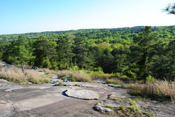
 There's a few places in the Atlanta Metro area that are ideal for hikers like me. Most people would go for a walk in their local park after a work day. However, I am not most people. Lake Lanier, Sweetwater Creek State Park, Kennesaw Mountain, and Stone Mountain are, in my opinion, the best hiking spots in Metro Atlanta. Stone Mountain is a massive monadnock, surrounded by lakes and streams. The Stone Mountain Park has a village with different fun for children, a railroad track, two hotels, lakes with boats, and most importantly for me and you, a variety of hiking trails, ranging from 3/4 of a mile long to 5 miles long. This hike occurred on Wednesday, April 16, 2014. My plan was to park at the Stone Mountain Walk-Up Trailhead, follow the Stone Mountain Walk-Up Trail to the Cherokee Trail, and from there, hike the Cherokee Loop Trail counter-clockwise back to the starting point. Summary R/T Length of Trail: 5.3 Miles Duration of Hike: 2:50 Type of Hike: Circuit Difficulty Rating: 3 out of 10 Pros: This hike is mostly easy and well-marked on wide, level trails Cons: There is one section of the trail that requires walking and sometimes scrambling across exposed rock on the west side of Stone Mountain Points of Interest: Numerous views of and from Stone Mountain; Venable Lake; Stone Mountain Lake Trail Blaze Color(s): Cherokee Trail - White Best Season(s) to Hike: Year-round Fees: The fees here are rather upscale for a hiking destination - you must pay $15 per vehicle upon entering the park, and there is also an annual pass that costs $40. However, do not consider Stone Mountain as a hiking destination. Instead, consider it is a touristic attraction. Beginning Point: Stone Mountain Walk-Up Trail Parking Lot Directions: From Atlanta, GA: Follow US 78 East. Once you merge into US 78 (Freeway), drive 8.3 miles to Exit 8 (Stone Mountain Park Main Entrance). Take Exit 8. Pay entrance fee at booth, and drive up Jefferson Davis Drive to T-shaped intersection. Take a right onto Jefferson Davis Drive, and drive 1 mile to the large parking lot on the left. The parking lot can be full even on weekdays. I arrived around 6 PM on a weekday, and there were few parking lots in the front end. There were more spaces in the back end, but in my previous trips here, even back end spaces were limited. Details This past weekend, I was busy, so I wasn't able to go hiking as I usually do. However, I had some time Wednesday afternoon and evening, and I decided I could go hiking somewhere in Metro Atlanta. I have been to Stone Mountain many times, and I have hiked this trail many times, but I keep hiking it again, due to its proximity to my house. It was a beautiful sunny day, and the weather was unusually cool for this time of the year (low 60s). When I arrived at the trailhead for the trail, I was surprised to find very few parking spaces in the front end. This place does get busy n weekends, but on weekdays I did not think it would be so busy. Fortunately most people go on the Walk-Up Trail to the top of Stone Mountain, which wasn't in my plans today. To get onto the Cherokee trail though, I first needed to hike up part of the Walk-Up Trail. At the start of the trail, you will cross railroad tracks, and then immediately begin the ascent. The whole Walk-Up Trail is on stone, so take your time up the ascent. No scrambling is needed, but there's lots of rocks... rocks, everywhere. At 0.1 mile, there will be a group of flags to the right. At 0.3 miles, there will be an intersection with the white-blazed Cherokee Trail. It really doesn't matter whether to go left or right. I have done it both ways, and there doesn't seem to be any measurable difference. Today, I decided to take a right. After the first 0.3 miles on the Walk-Up Trail, you are pretty much done with the climbing for the rest of the day. The Cherokee Trail starts out level, but don't get used to it for the near term. Shortly, you will cross a service road used by park maintenance workers to drive to the top of the mountain. After this, the trail starts descending the elevation you gained on the Walk-Up Trail. The trail opens up onto an open rock face, which is pretty steep. Follow the white blazes on the rocks. This is probably the hardest section of the hike, but if you will be careful, it will be a piece of cake. At the same time, there will be nice views to your right (south). On a good day, you could see downtown Atlanta, if you look back to your west. Around 0.5 miles after the start of the Cherokee Trail, the trail will exit the rock face and enter the forest. There will be a rock hop over a small stream, and then you will need to cross the railroad again. You could have escaped all the climbing and descent by following the road, but isn't that boring? After the railroad, there will be a trail junction. To the right, an orange-blazed connector trail leads to the Nature Garden Trail, and eventually back to the parking lot. Meanwhile, the Cherokee Trail turns left. There will soon be an old chimney on the right, and then it is all down, down, down. Soon, you will be paralleling Jefferson Davis Drive. There will be a large downed tree at one point, and then a series of steps will take you up and over Jefferson Davis Drive. The trail then follows a playground on its right, before popping up onto the dam of a small lake (Howell Lake). the trail crosses a small footbridge at the end of the dam, and then goes down to the level of Venable Lake. There will be another footbridge over another creek shortly, and then the trail will reach a different road (Stonewall Jackson Drive). Here, there is an option. The Cherokee Trail crosses the road and keeps paralleling the right bank of Venable Lake, while across the bridge over the lake, an orange-blazed connector trail follows the left bank of the lake. Both options lead to the same spot, because both trails meet at the dam of Venable Lake. I tried both, and it doesn't really matter which one to take. Today, I decided to do the connector along the left side of the lake. To get there, you will need to go along the road, cross the bridge over the lake, and then go right. The trail will cross a feeder stream of the lake by footbridge, and then cross several smaller streams via rock hop. The trail winds along the banks of the shore seemingly endlessly, although eventually, you will reach a junction with the Cherokee Trail again. The Cherokee Trail goes straight and to the right,. Going t the right would make a nice loop if you started somewhere near the bridge and just want to go around the lake. I went forward, however. The new, bigger lake is now Stone Mountain Lake to your right. The trail will keep following the banks of the lake, occasionally crossing feeder streams. There will be a couple of small open rock faces along the way. Keep following the white blazes over the rocks to not lose the trail. But this has to end at some point, right? Yes. Eventually, the trail reached a road and a covered bridge. The road was Covered Bridge Lane, and the covered bridge is said to be very old. I took a picture of it, as well as the information sign about the bridge, and included the pictures below. On the other side of the bridge, there was a small island, and a nice 3/4 mile long trail, which I did last fall. It it easy to lose the trail here too. It seems like there's nowhere to go but up the road, but the trail actually bears right over the road, and then parallels it. It follows a narrow area of land between the road and the lake. Shortly afterwards, it reaches a paved part of the trail that goes right along the waters edge. Basically, this was made for fishermen to be able to fish with ease. The trail regains its dirt tread shortly, and follows another of the numerous fingers of the lake. On this next finger, there was a confusing section of trail. There was an unmarked pathway that went forward toward the road, while the Cherokee Trail turned right onto a bridge leading to an old mill. On this day, the mill wasn't active, although on previous visits, I saw that it was. The bridge rounds the mill building, and then goes onto the other bank of the finger. Here, the trail turned left, finally leaving the lake for good. It followed a small channel of water used for the mill, and then there will be several turns as it winds its way towards the road. Just follow the signs and white blazes, and you will be fine. Eventually the trail crosses the road, and becomes much wider on the other side. It shortly crosses the railroad, and then starts following a small stream. However, there is more confusion ahead. The trail soon turns right onto a service road, and immediately turns left. This section would have been really confusing without the numerous signage. I should say that the park did a very good job of marking and blazing the trail. After the service road crossing, the trail reaches the laser lawn area and a paved pathway. Here, the trail follows the paved path by bearing left. It follows the edge of the large lawn, and skirts a small lake. The massive, steep granite face of Stone Mountain is visible best from this area. After rounding the lawn, the trail goes off the paved pathway and turns left onto a wide dirt path. Soon, it will start climbing slowly up the mountain back to the starting point. At the start of the gradual climb, there will be an unsigned connector trail that goes to the right. This connector trail leads to another trailhead for the trail. The Cherokee Trail keeps going forward, with a very gradual climb, and soon reaches another connector trail. Here, you have an option. The Connector goes to the right straight to the parking lot with no climbing, while the Cherokee Trail starts a steep climb to the Walk-Up Trail. The Cherokee Trail option is both harder and longer, so I usually take the Connector. You can take the Cherokee Trail option if you want some additional exercise. The connector trail is less visible then the Cherokee Trail. It will cross several large rock faces ,and a service road. Eventually, it exits onto a paved path that led out onto the parking lot. This was a very nice hike, especially being so close to my house. The combination of nice views, numerous water features, and good exercise, makes this a manageable half-day hike. The only downside is that there is a $8 fee at the entrance, but if you close by and come often, then a yearly pass (35) is a good idea. I have the yearly pass, and I make the best of it. Enjoy my pictures in the gallery below, and check back time to time, to see if I write any updates to this trail (as I hike it pretty often). Variations Hike the Walk-up Trail to the summit of Stone Mountain and the Kings Island Trail, in addition to the Cherokee Trail - 7.9 Miles Bonus Stops Check out the historic village and its attractions at the base of Stone Mountain on the north side of the park. Pictures
2 Comments
Great article. I ran across it while I was trying to find an answer to a curiosity that I have maybe you know the answer. Q: Why do signs and other information say that the trail to the Stone Mountain summit is 1 mile? According to my Fitbit it is actually about a mile and a half. Just wondering. HIKE ON!!! 8/3/2022 05:30:24 pm
Edirne ECA servisi en uygun fiyat ve en hızlı servis garantisi ile sizlerle. https://www.edirneklimaservisi.com/edirne-eca-servisi/ Leave a Reply. |
About MeMark Oleg Ozboyd Dear readers: I have invested a tremendous amount of time and effort in this website and the Georgia Waterfalls Database the past five years. All of the work that has gone in keeping these websites updated with my latest trip reports has almost been like a full-time job. This has not allowed me to pick up a paid job to save up money for college, and therefore, I I've had to take out loans. If you find the information on this website interesting, helpful, or time-saving, you can say "thanks" and help me out by clicking the button above and making a contribution. I will be very grateful for any amount of support you give, as all of it will apply toward my college tuition. Thank you!

Coming in 2022-2023?
Other Hiking WebsitesMiles HikedYear 1: 540.0 Miles
Year 2: 552.3 Miles Year 3: 518.4 Miles Year 4: 482.4 Miles Year 5: 259.9 Miles Archives
March 2021
Categories
All
|
 RSS Feed