HIKING THE APPALACHIANS AND BEYOND
  • Home
  • Trail Reports
    • Best Hikes
    • Hikes with Scenic Views
    • Hikes with Water Features
    • Alabama
    • Georgia
    • Florida
    • North Carolina
    • South Carolina
    • Tennessee
    • Vermont
    • Virginia
  • Map
  • Hike List
  • Testimonials
  • Resources
  • Contact Us
  • Southeast Nature Society
    • Our Team
  • Georgia Waterfalls Database

Chattahoochee National Forest: Brasstown Bald via Jack's Knob Trail

6/8/2014

2 Comments

 
Picture
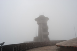
The highest mountain in Georgia is Brasstown Bald, just shy of 4800 feet. The mountain is surrounded by the Brasstown Wilderness, which has some animal and plant species not found anywhere further south. Brasstown Bald is accessible by several trails, and a road. The views from the top are 360 degrees, and you can see miles... but not on days like this day. This hike occurred on Saturday, May 31st, 2014. My plan was to take the Jack's Knob Trail from the parking at the beginning of GA State Route 180-Spur, and follow the trail all the way to the Brasstown Bald parking lot. From there, I would follow the Summit Trail to the tower at the top, and then, retrace my steps. However, I didn't quite mean for a heavy thunderstorm to be included in this plan. 

R/T Length of Trail: 4.5 Miles
Duration of Hike: 4 Hours
Type of Hike: Out-and-Back
Difficulty Rating: 7 out of 10; very good trail condition, but steep ascent that seems to last longer than it actually is
Beginning Point: Small parking pullout on the corner of GA State Route 180 and GA State Route 180-Spur
'Tis a warm and sunny Saturday morning. Wispy clouds are drifting across blue skies. You'd think there wouldn't be rain on a day like this, right? Well you're wrong. I didn't have much time for hiking this weekend, but I figured I would fit in a few hours for a short hike somewhere. Obviously, I couldn't go farther than the Chattahoochee National Forest, and I decided that I could try to check out Brasstown Bald, since I haven't been there since last November. So far, I had ascended Brasstown Bald twice via the Arkaquah Trail (Over 12 miles roundtrip) from the west side. The second trail that leads to Brasstown Bald, and the shortest (if you don't count parking at the upper parking lot and just hiking up and down the paved path or taking the shuttle), is the Jack's Knob Trail. The Jack's Knob Trail technically starts from the upper parking lot just below the Brasstown Bald summit. From there, it follows Wolfpen Ridge to the south, before steeply descending to GA State Route 180, where there is another trailhead. From there, the trail goes deep into the Mark Trail Wilderness, and ends at the Appalachian Trail at Chattahoochee Gap. Chattahoochee Gap is where the spring that gives birth to the Chattahoochee River is located. Today, I didn't have time to hike the whole trail, which is 9 miles roundtrip, but I figured that i had just enough time to hike from GA State Route 180 to the Brasstown Bald summit and back. This is also a good way to escape the $3 fee, if you park near the top. As I was driving north on GA State Route 400, the cumulonimbus clouds kept building... and building... and building. By the time I crossed over the Appalachian Trail divide on US Route 129, the horizon revealed itself in a mass of dark gray, and the Brasstown Bald summit was shrouded in dark clouds. Uh-oh. I try to hike every weekend, whether it is rain or shine, but I wasn't totally prepared for this unexpected weather change. Just as I reached the trailhead, it started raining. And it became a downpour fast. I waited for the first round of rain (and thunder) to pass, and when it lightened up, I started on the trail. I took an umbrella with me, because the sky was definitely saying that there was going to be more rain soon. 


The parking lot for the trail here is pretty small. There's space for maybe 8 cars at most, although on the day I came, there were only 2 others. I am pretty sure this lot is filled on good weekends, as there's quite a few people who'd want to save money, even if it is only $3. Once you have parked, you need to walk a little bit up the road to the trailhead kiosk, which talks about the $3 fee, and has some information regarding the area. This kiosk had me thinking that I needed to pay the fee here too, but I never found where to pay, so I figured it meant for anyone parked inside of the gate on GA State Route 180-Spur. The trail immediately entered the woods, and there was a weird sign saying the trail is closed to mountain bikers, horses, and "pack stock". Who in the world would bring pack stock on a trail? This was the first time I ever saw anything like that on a warning sign. Anyway, the trail paralleled the road for about 0.1 miles. However, the trail quickly crossed an old and gated road, and started the ascent. While this trail was easier than the one I did last week, it was mainly easier due to length. It would probably have been harder, if the length was the same. The trail did have some switchbacks as it ascended, but they weren't helping much, as they were short. The first part wasn't very steep yet, as the trail kept crossing "steps" on the ascent, and there were brief flat sections due to that. However, the final steep climb started around 0.6 miles from the start. This climb had switchbacks, but like I mentioned before, they didn't help much. It seemed longer than it actually was. Closer to the 1 mile mark, the rain started again. And it was heavy. Somehow I got drenched even with the umbrella. The conclusion of my ascent was greeted with a loud thunder clap. The top of Wolfpen Ridge was partially in the clouds and fog. Along the ridgetop trail there were several blooming rhododendron bushes. At 1.3 miles, the trail reached a campsite, and there was a small overlook on the right. All I could see was fog though. Fog, fog, and fog. What happened to the blue skies at home? At the overlook, the trail turned left and started descending. The descent was without switchbacks but short. At 1.6 miles from the start, the trail emptied itself into the Brasstown Bald Summit Trail Parking Lot, and there was a trailside kiosk at the end of the Jack's Knob Trail. 


From the end of the Jack's Knob Trail, you have to cross the huge parking lot to the visitor center. Here, a paved path starts. There is a sign that the Brasstown Bald Summit is 0.6 miles away. The paved path, although with switchbacks, seems like the steepest part of the hike to me. The trail reaches the Wagon Train Trail at 0.1 miles. The trail goes to the right into the Brasstown Bald Wilderness to reach the Young Harris College eventually. That was a hike for another day. The Summit Trail then passes through some rhododendron tunnels, which are beautiful in spring, and passes some benches for those who are too tired. The trail crosses the Summit Shuttle Road at 0.5 miles, and then makes the final push to the summit. When I was at the big parking lot a little lower, I could see that Brasstown Bald was gone in the clouds. Now that i finished the ascent, I could see nothing outside of the summit. There was some mountain laurel and more rhododendron at the summit, but the mountain laurel wasn't fully blooming yet. I ascended the steps to the fire tower, and looked around. I knew how the view looks like, because I was here in November, but today it was completely different. It looked like an abyss, as everything was  shrouded in fog. Not a whole lot to look at.  I stayed for a bit ,but nothing changed. On my way back down the Jack's Knob Trail, the rain started again. It wasn't as heavy as before, but it was still enough to get me wet further. Oh well, I didn't need to care by now. The descent in the rain seemed endless, but eventually it ended. 


In summary, this is a hard but relatively short hike for those who want to save some money. Most people, ho are in fair shape can probably do it, but make sure to take your time. It isn't as easy as it seems. Below are my pictures.
2 Comments
Sue Crowe link
10/22/2018 02:13:56 pm

American Trails is a non-profit trail organization that hosts the National Recreation Trails Database, by agreement, with the National Park Service and the Forest Service.

We are in the process of updating the software application to a map based platform.

The Jacks Knob Trail is a designated National Recreation Trail. Would it be possible to use a couple of your photos for the database, with proper photo credit? The photo will appear in the search feature: http://www.nrtdatabase.org/trailDetail.php?recordID=204

Reply
Edirne ECA servisi link
8/3/2022 05:43:09 pm

Edirne ECA servisi en uygun fiyat ve en hızlı servis garantisi ile sizlerle. https://www.edirneklimaservisi.com/edirne-eca-servisi/

Reply


Leave a Reply.

    About Me

    Mark Oleg Ozboyd
    I'm an avid outdoor explorer and a hobbyist landscape photographer. I'm 21 years old and have been hiking since 2011. Originally based out of Atlanta, Georgia, I started out by occasionally hiking short trails throughout well-known Georgia State Parks. During 2012 and 2013, I began to expand my trips into adjacent states, as well as into the wilder National Forest areas rather than just State Parks. Throughout the years that followed, as I slowly ran out of popular hiking trails in my area, I began to search for and hike in more seldom-visited areas. Today, you can find me out in the woods every weekend, whether it's on an official trail or bushwhacking through cross-country terrain without any paths. I now attend Washington & Lee University and am exploring Virginia and West Virginia. My other hobbies include chess, science, old music, and meteorology. I have 3 years of amateur weather forecasting experience, having studied a lot of meteorology basics over the years. I am also a student at European School of Music where I learned that music and nature have a lot in common. Listening to good music inspires me to capture nature's beauty on the camera in different aspects that also make me recall many beautiful music pieces that I've heard.​


    Dear readers: I have invested a tremendous amount of time and effort in this website and the Georgia Waterfalls Database the past five years. All of the work that has gone in keeping these websites updated with my latest trip reports has almost been like a full-time job. This has not allowed me to pick up a paid job to save up money for college, and therefore, I I've had to take out loans. If you find the information on this website interesting, helpful, or time-saving, you can say "thanks" and help me out by clicking the button above and making a contribution. I will be very grateful for any amount of support you give, as all of it will apply toward my college tuition. Thank you! 

    Enter your email address to subscribe for trail reports:

    Delivered by FeedBurner


    Picture
    Coming in 2022-2023?

    Other Hiking Websites

    DWHike's Adventures
    Florida's Natural Wonders
    Florida Trailblazer
    Meanderthals
    Mountain Images
    by Bernie Boyer

    North Carolina Waterfalls with
    ​Kevin Adams
    Take-a-Hike!
    Tennessee Landforms
    Waterfall Page
    Waterfall Adventurer
    Zach's Mild Adventures

    Miles Hiked

    Year 1: 540.0 Miles
    Year 2: 552.3 Miles
    ​Year 3: 518.4 Miles
    Year 4: 482.4 Miles
    Year 5: 259.9 Miles

    Archives

    March 2021
    February 2021
    January 2021
    November 2019
    October 2019
    September 2019
    August 2019
    July 2019
    June 2019
    February 2019
    January 2019
    December 2018
    November 2018
    October 2018
    August 2018
    July 2018
    June 2018
    May 2018
    April 2018
    March 2018
    February 2018
    January 2018
    December 2017
    November 2017
    October 2017
    September 2017
    August 2017
    July 2017
    June 2017
    May 2017
    April 2017
    March 2017
    February 2017
    January 2017
    December 2016
    November 2016
    October 2016
    September 2016
    August 2016
    June 2016
    May 2016
    April 2016
    March 2016
    January 2016
    December 2015
    November 2015
    October 2015
    September 2015
    August 2015
    July 2015
    June 2015
    May 2015
    April 2015
    March 2015
    February 2015
    January 2015
    December 2014
    November 2014
    October 2014
    September 2014
    August 2014
    July 2014
    June 2014
    May 2014
    April 2014
    March 2014
    February 2014

    Categories

    All
    Adel
    Adirondack Park
    Alabama
    Alfred A. Ring Park
    Allegheny Trail
    Amicalola Falls State Park
    Anniston Area
    Apalachicola Bluffs And Ravines Preserve
    Apalachicola National Forest
    Apalachicola/Port St. Joe Area
    Apopka
    Appalachian Trail
    Appling
    Art Loeb Trail
    Aska Trail System
    Bakersville
    Balm-Boyette Scrub Preserve
    Balsam Lake Recreation Area
    Bankhead National Forest
    Bartow County Parks
    Bartram Trail
    Basinger
    Beersheba Springs
    Benton
    Benton Mackaye Trail
    Berry College Trail System
    Best Hike
    Big South Fork National Recreation Area
    Black Bear Wilderness
    Black Rock Mountain State Park
    Blairsville
    Blakely
    Blood Mountain Wilderness
    Blowing Rock
    Blue Ridge
    Blue Ridge Parkway
    Boone
    Bradenton
    Bradenton Beach
    Brasstown Bald
    Brasstown Wilderness
    Brevard
    Bryson City
    Buchanan
    Bucks Pocket State Park
    Bulow Creek State Park
    Bulow Plantation Ruins State Park
    Caesars Head State Park
    Caladesi Island State Park
    Calhoun
    Camel's Hump State Park
    Cashiers
    Caspersen Beach Park
    Catfish Creek State Park
    Caves
    CC Putnam State Forest
    Cedar Point Environmental Park
    Chatsworth
    Chattahoochee National Forest
    Chattanooga
    Chattanooga Valley
    Chattooga National Wild And Scenic River
    Cheaha Wilderness
    Cherohala Skyway
    Cherokee
    Cherokee National Forest
    Chiefland Area
    Chillhowee Recreation Area
    Chipley
    Chunky Gal Trail
    Circle B Bar Reserve
    Citico Creek Wilderness
    Citrus Wildlife Management Area
    Clarkesville
    Clayton
    Cleevland
    Cleveland
    Cloudland Canyon State Park
    Cohutta Wilderness
    Collier-Seminole State Park
    Cordele
    Cornelia
    Covington
    Crestview Area
    Crew-land-and-water-trust
    Cullowhee
    Cumberland Trail
    Dahlonega
    Dalton
    Dawson Forest Wildlife Management Area
    Dawsonville
    Dayton
    De Soto National Memorial
    DeSoto State Park
    Dillard
    Double Springs
    Ducktown
    Duncan Ridge Trail
    Dunlap
    Eagle's Rest Park
    Eastpoint
    Econfina Creek Wildife Management Area
    Eglin Air Force Base
    Elizabethton
    Elkins
    Elk Knob Game Lands
    Elk Park
    Ellicott Rock Wilderness
    Ellijay
    Emerson Point Preserve
    Englewood Area
    Enota Retreat
    Erwin
    Falling Waters State Park
    Fayetteville
    Fires Creek Recreation Area
    Fire Tower
    Flint River
    Florence Area
    Florida
    Florida Caverns State Park
    Florida Trail
    Foothills Trail
    Fort Mountain State Park
    Fort Myers Area
    Fort Payne
    Fort Payne Area
    Fort Yargo State Park
    Franklin
    Franklin Delano Roosevelt State Park
    Franklin-Marion State Forest
    Frozen Head State Park
    Gainesville
    Gainesville Area
    Gatlinburg
    George Washington National Forest
    Georgia
    Georgia Veterans Memorial State Park
    Glasgow
    Gorges State Park
    Grandfather Mountain State Park
    Great Smoky Mountains National Park
    Greeneville
    Green River Game Lands
    Gruetli-Laager
    Grundy Forest State Natural Area
    GTM Reserve
    Guana River Wildlife Management Area
    Hayesville
    Helen
    Hiawassee
    High Falls State Park
    Highlands
    Highlands Scenic Highway
    Hillsborough River State Park
    Hinson Conservation & Recreation Area
    Historic Sites
    Honeymoon Island State Park
    Hot Springs
    Huntington
    Inverness Area
    Jackson
    Jasper
    Jefferson National Forest
    Joan M. Durante Park
    Jonathan Dickinson State Park
    Jones Gap State Park
    Joyce Kilmer Slickrock Wilderness
    Joyce Kilmer - Slickrock Wilderness
    Juniper Prairie Wilderness
    Kelly Park
    Keown Falls Recreation Area
    Kolomoki Mounds State Park
    LaFayette
    Lake City Area
    Lake George Wild Forest
    Lake June-in-Winter State Park
    Lakeland Area
    Lake Placid
    Lake Russell Wildlife Management Area
    Lake Wales Ridge State Forest
    Laurel Fork North Wilderness
    Leffis Key Preserve
    Leon Sinks Geological Area
    Lexington
    Lineville
    Linville
    Linville Gorge Wilderness
    Lithia Springs
    Little Frog Wilderness
    Little Manatee River State Park
    Little River Canyon National Preserve
    Longboat Key
    Long Trail
    Lookout Mountain
    Lookout Mountain Battlefield
    Lovingston
    Lula Lake Land Trust
    Lumpkin
    Maggie Valley
    Manatee Springs State Park
    Marianna Area
    Mark Trail Wilderness
    Marlinton
    Mccaysville
    McMinville
    Mentone
    Middlesex
    Mistletoe State Park
    Monongahela National Forest
    Montreat
    Mountain Bridge Wilderness Area
    Mountain City
    Mountains To Sea Trail
    Mountains-to-Sea Trail
    Mount Rogers National Recreation Area
    Myakka River State Park
    Myron B. Hodge City Park
    Nantahala National Forest
    Naples
    Naples Area
    Natural Bridge State Park
    Neal Preserve
    New Castle
    Newport
    New River Gorge National Park
    New York
    North Carolina
    Ocala Area
    Ocala National Forest
    Ocean-to-Lake Trail
    Oconee State Park
    Oconee Station Historic Site
    Okaloacoochee Slough State Forest
    Oldsmar
    Oneida
    Orlando Area
    Ormond Beach
    Oscar Scherer State Park
    Oxford
    Palatka
    Palmetto Trail
    Panama City Area
    Panthertown Valley
    Parrish
    Paynes Creek Historic State Park
    Peaks Of Otter Recreation Area
    Pigeon Crockford Mountain Wildlife Management Area
    Pigeon-Crockford Mountain Wildlife Management Area
    Pigeon-Crockford Wildlife Management Area
    Pine Mountain
    Pinhoti Trail
    Pinnacle Park
    Pisgah Civitan Park
    Pisgah National Forest
    Pittman Center
    Pond Mountain Wilderness
    Ponds/Lakes
    Prentice Cooper State Forest
    Providence Canyon State Park
    Pumpkintown
    Quick Point Nature Preserve
    Raven Cliffs Wilderness
    Reed Bingham State Park
    Reliance
    Rice Creek Conservation Area
    Riverview Pointe Preserve
    Robbinsville
    Robinson Preserve
    Rock Creek Gorge Scenic Area
    Rock Island State Park
    Rome
    Rosman
    Sale Creek
    Salem
    Salt Springs
    Saluda
    Santa Rosa Beach
    Sarasota
    Sarasota Area
    Savage Gulf State Natural Area
    Scenic Views
    Scottsboro Area
    Sebring Area
    Sewanee
    Sheltowee Trace Trail
    Shining Rock Wilderness
    Signal Mountain
    Sipsey Wilderness
    Sky Valley
    Smithgall Woods State Park
    Snowbird Backcountry Area
    Soddy Daisy
    Soddy-Daisy
    Sopchoppy
    South Carolina
    South Cumberland State Park
    Southeastern Cave Conservancy
    Southern Nantahala Wilderness
    Sparta
    Sprewell Bluff Park
    Spring City
    Spring Hill
    Springs
    Spruce Pine
    Standing Indian Backcountry Area
    St. Augustine
    St. George Island State Park
    St. Joseph Bay State Buffer Preserve
    St. Marks Area
    St. Marks National Wildlife Refuge
    Stone Mountain
    Stone Mountain Park
    Suches
    Sumatra
    Sumter National Forest
    Suwannee River
    Swallow Creek Wildlife Management Area
    Sweetwater Creek State Park
    Sylva
    Talladega National Forest
    Tallahassee Area
    Tallulah Falls
    Tallulah Gorge State Park
    Tampa Bay Area
    Tate City
    Tate's Hell State Forest
    Tea Creek Wildlife Management Area
    Tellico Plains
    Tennessee
    Thomaston
    Toccoa
    Topsail Hill State Park
    Torreya State Park
    Townsend
    Tracy City
    Tray Mountain Wilderness
    Trenton
    Triple Creek Preserve
    Troutdale
    Unaka Mountain Wilderness
    Upper Tampa Bay County Park
    Venice
    Vermont
    Virgin Falls State Natural Area
    Virginia
    Virginia Outdoors Foundation
    Vogel State Park
    Wakulla Springs State Park
    Waleska
    Walhalla
    Wartburg
    Water Features
    Waynesville
    Weedon Island Preserve
    Weeki Wachee Preserve
    Wekiwa Springs State Park
    West Palm Beach Area
    West Virginia
    Whitehall
    White Springs
    Winder
    Withlacoochee State Forest
    Young Harris

    RSS Feed

TRAIL REPORTS

Hikes in Alabama
​Hikes in Florida
Hikes in Georgia
Hikes in North Carolina
Hikes in South Carolina
Hikes in Tennessee
Hikes in Virginia

Hiking Resources

Alabama Resources
​
Florida Resources
Georgia Resources
North Carolina Resources
​South Carolina Resources
​
Tennessee Resources

Other

Contact
Map of Hikes
Alphabetical List of Hikes
Southeast Nature Society
© COPYRIGHT 2014-2024
​ALL RIGHTS RESERVED.
Important: I disclaim any responsibility for any damage or personal injury that may occur as a result of the activities and information found on this website. All outdoor activities, especially off-trail hiking, are done at your own risk. Never hike or head into that area that may be above your fitness or experience level.
  • Home
  • Trail Reports
    • Best Hikes
    • Hikes with Scenic Views
    • Hikes with Water Features
    • Alabama
    • Georgia
    • Florida
    • North Carolina
    • South Carolina
    • Tennessee
    • Vermont
    • Virginia
  • Map
  • Hike List
  • Testimonials
  • Resources
  • Contact Us
  • Southeast Nature Society
    • Our Team
  • Georgia Waterfalls Database