HIKING THE APPALACHIANS AND BEYOND
  • Home
  • Trail Reports
    • Best Hikes
    • Hikes with Scenic Views
    • Hikes with Water Features
    • Alabama
    • Georgia
    • Florida
    • North Carolina
    • South Carolina
    • Tennessee
    • Vermont
    • Virginia
  • Map
  • Hike List
  • Testimonials
  • Resources
  • Contact Us
  • Southeast Nature Society
    • Our Team
  • Georgia Waterfalls Database

Berry College Trail System: House O' Dreams Loop via Longleaf Trail, Rome, Georgia

1/10/2015

3 Comments

 
Picture
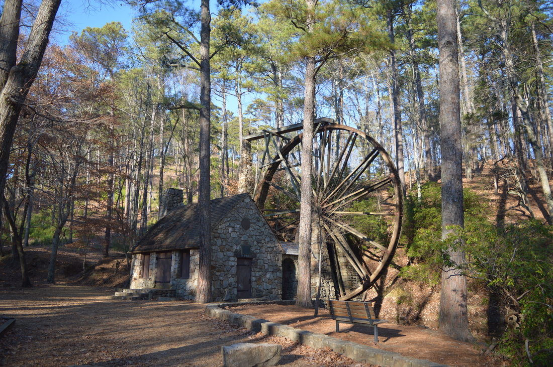
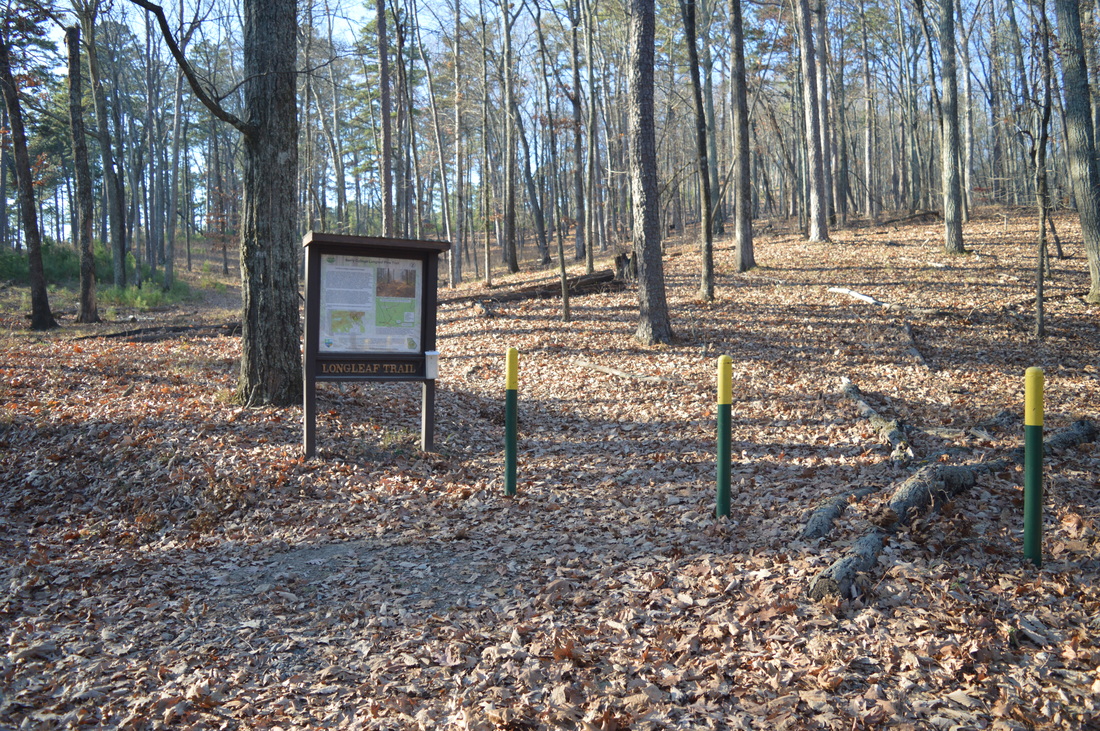
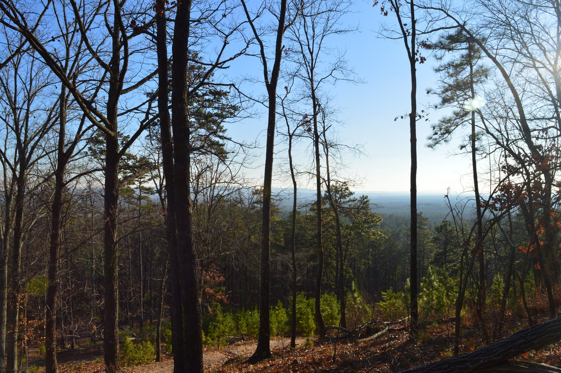
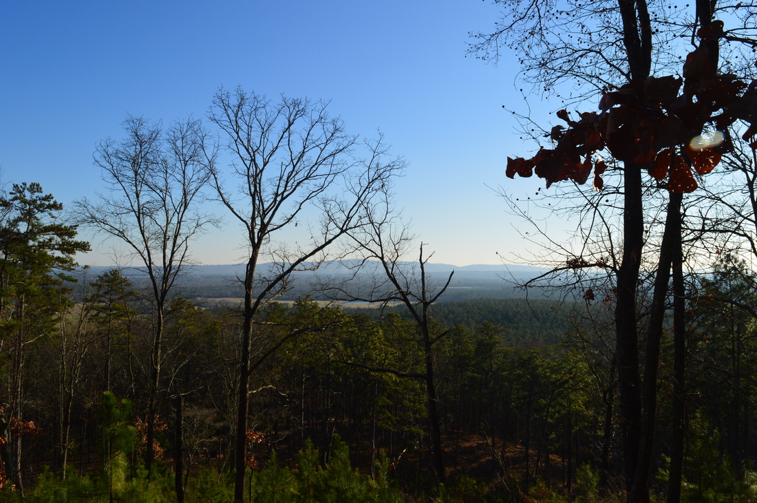
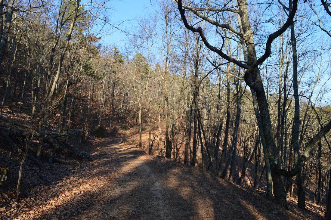
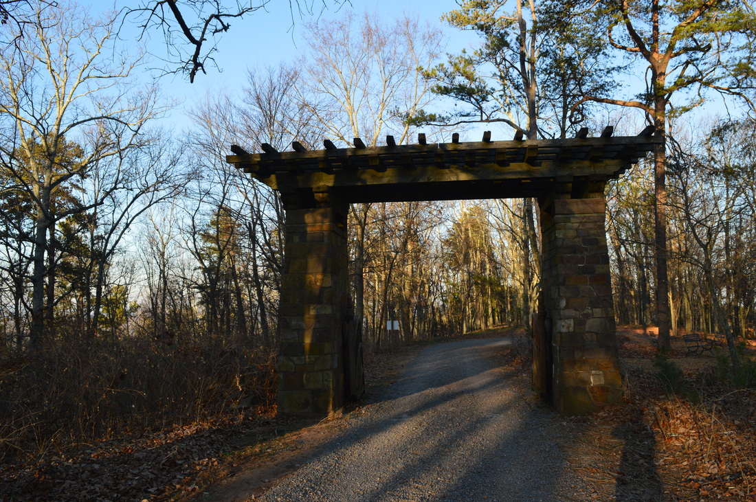
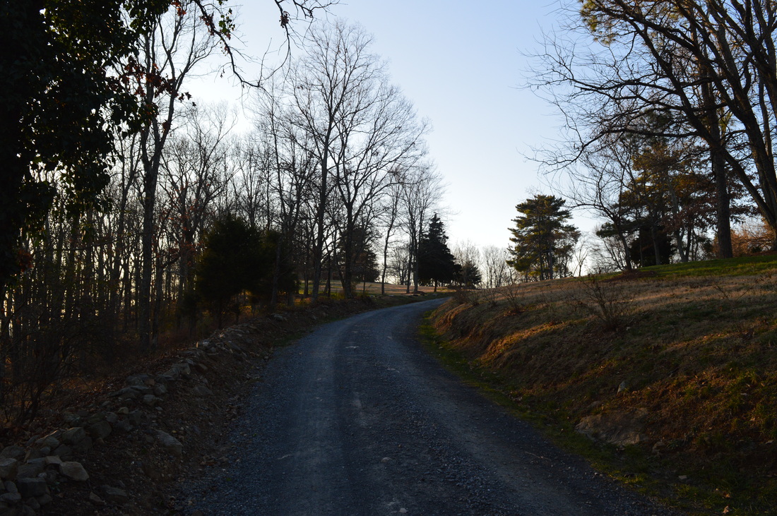
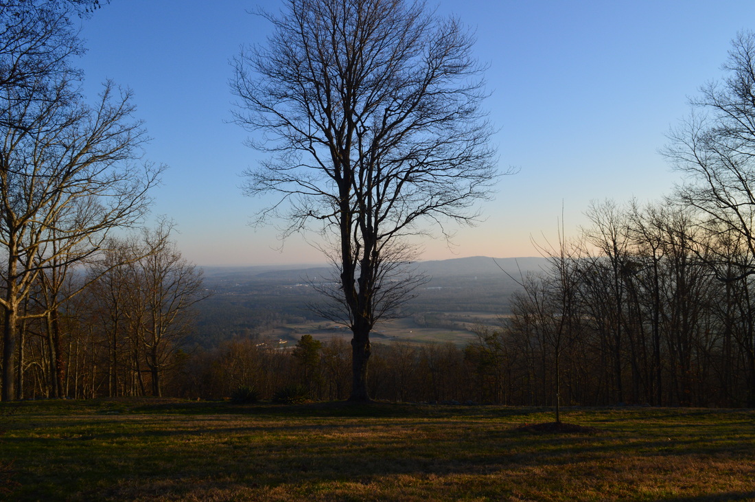
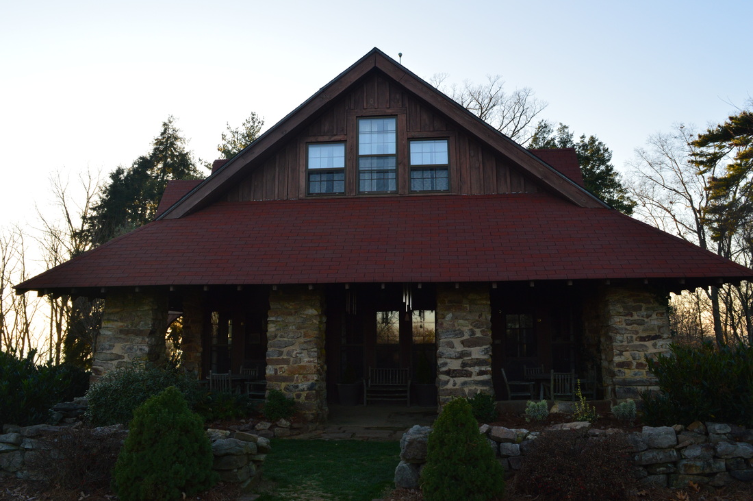
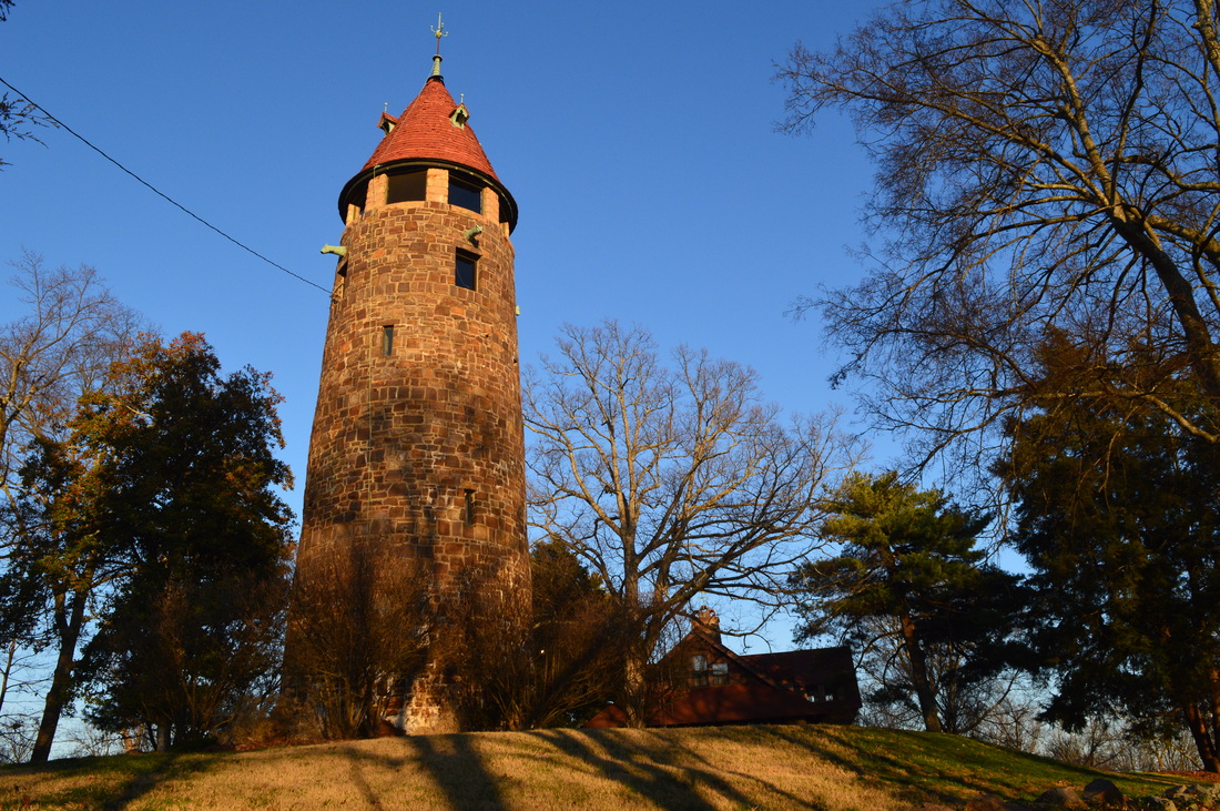
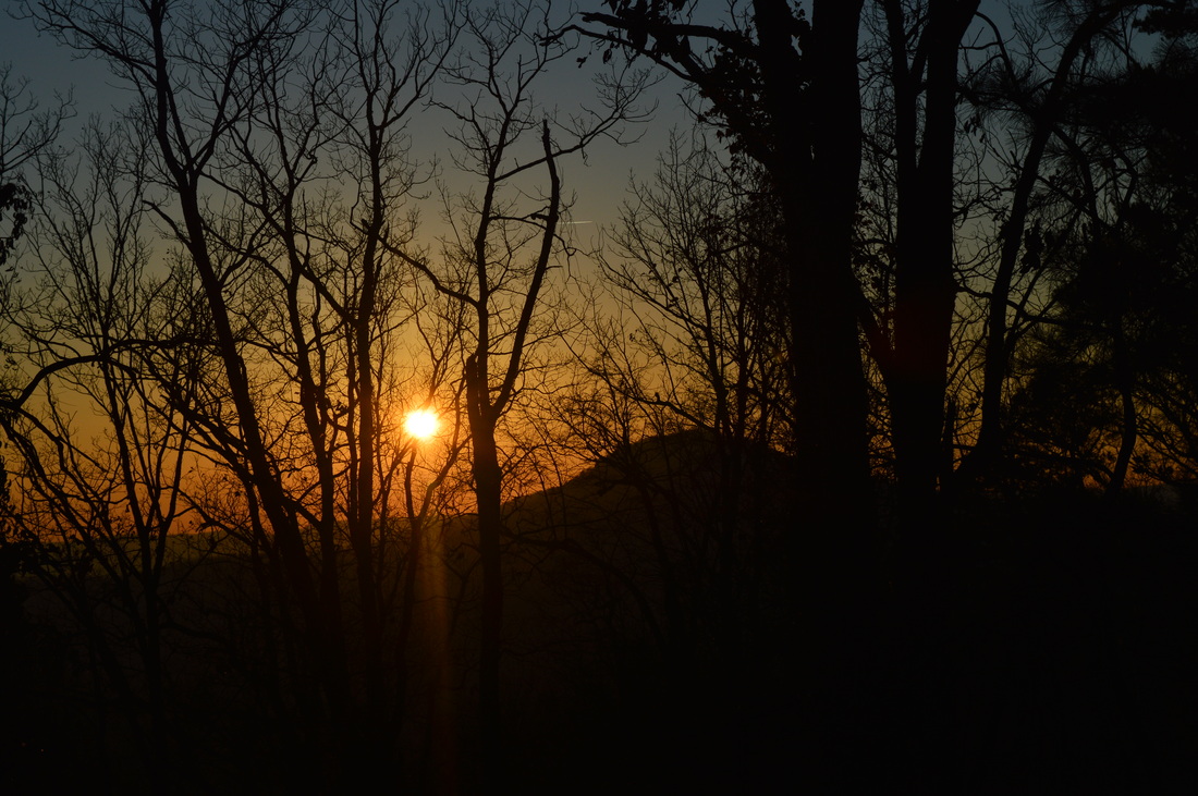
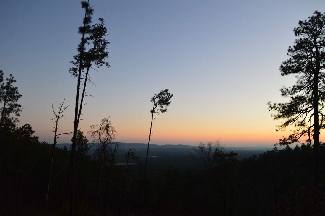
Berry College has a campus of 30,000 acres - the largest in the world. It was Martha's Berry dream to create a good school for mountain children, and it started way back in 1902. 20 years later, the grateful students of Marta's school built her a resort house on the summit of Lavender Mountain. While she would rarely spend the night in the house, she would often invite guests to the house and spend days with them together. From the house, you have good views of the Oostanaula River Valley, as well as some views of Berry College's campus. Below the mountain, the Old Mill is a historical attraction that attracts many people on good days. The Longleaf Trail goes through an experimental longleaf pine forest - controlled burns along that trail open up various views. This hike occurred on Saturday, December 13th, 2014. My plan was to park at the Old Mill, then go down the gravel road to Longleaf Trail. Next, I planned to hike the steep Longleaf Trail to the House O' Dreams Loop. My plan was to turn right and follow first the old forest road, then the gravel road, to the House O' Dreams. From there, I would follow the Hike/Bike Trail over Lavender Mountain back to the old forest road, and turn left to go back to Longleaf Trail and close the loop. 

R/T Length of Trail: 6.1 Miles
Duration of Hike: 2:20 
Type of Hike: Lollipop 
Difficulty Rating: 5 out of 10
Pros: Historical features; good views
Cons: Plenty of old road walking 
Scenic Views: Views from Longleaf Trail - 3 out of 10; Views from Lavender Mountain - 4 out of 10
Water Features: None
Trail Blaze Color(s): None 
Best Season(s) to Hike: Winter 
Beginning Point: Old Mill on Berry College's Mountain Campus 
Directions: From Rome, Georgia: Follow US Route 27 north for 4 to 5 miles. Take a left at the traffic light for Berry College. In 0.3 miles, reach the roundabout. Take the first right, and in 0.3 miles, take a left onto Memorial Drive. Drive for 3.5 miles until you reach the Mountain Campus. Here, take the road that goes diagonally right. In 0.2 miles, reach a T-shaped intersection. Turn left here, and in 0.2 miles, bear left again. Follow this road for 0.7 miles until the parking area - the last 0.3 miles are unpaved. 
If you like historical hikes, this short one is for you. There are plenty of historical features, starting from the Old Mill right at the parking area. The Old Mill is pretty high - with a height of 42 feet! There are no trails to set foot on right from the Old Mill though. You have to walk down the road a bit from the parking area, reaching the start of the Longleaf Trail on the left at 0.2 miles. The star of the trail is marked by an informational kiosk. There will be several more of these interpretive kiosks along the Longleaf Trail. Most of the Longleaf Trail is steep climbing -  interrupted by the occasional eroded switchback. Luckily though, the trail is short. At 0.3 miles, a short spur trail leads off to the left with a view of the Old Mill below. I didn't take this trail. Take a right to follow the main trail. At 0.4 miles, views open up into the Oostanaula River Valley and Berry College's campus. These views are more or less visible for the remainder of the Longleaf Trail, due to the thin woods. In winter, the views are enhanced. The trail rounds a small hill and reaches a gap at 0.5 miles. One more short, stiff climb brings you up to a junction with the House O' Dreams Loop at 0.6 miles. This is where the loop section starts. There is barely ant difference in the direction you choose for the loop, but this description will describe the loop counter-clockwise. 


At the junction with the old road at 0.6 miles, take a right. This old forest road provides good winter views and also partial summer views at a powerline cut. Then, there will be an old gate, just before the old road dead-ends at a gravel road at 1.2 miles. I believe this road is open to vehicles. If you turn right, it will lead you back down to Berry College's Mountain Campus. Turning left leads to House O' Dreams, so turn left. You should shortly see a sign for House O' Dreams - 1.8 miles left to get there! The gravel road ascends more than the old forest road, but still gradually along the slopes of Lavender Mountain. At 1.9 miles, the road makes a U-Turn up onto the ridge, while an old road goes off to the right down the ridge. That road also leads down to Berry College. Keep following the gravel road through the gates for House O' Dreams. The road is now ascending along Lavender Mountain's main ridge, but soon, the ridge gets too steep, so a couple of long switchbacks ease the climb. After the switchbacks, you're almost there. You will know you are getting close, when you see the open lawns ahead of you. The gravel road makes one final climb up to the summit of Lavender Mountain. This is the site of House O' Dreams. There are views to both the south and north, with the artificially-cleared views to the south being the better ones. Take a minute and peek around the house. It is a very simple house, but in a beautiful place. I really like the garden in the front. Behind the house is an old water tower that also served as an observation tower.  Public access is restricted to the tower. 


Once you've seen everything at and around the house, take the Hike/Bike Trail on the west side of the summit. The trail may be marked as a Biking Trail, but it's for both hikers and bikers. The trail first rounds the west end of the summit then follows the ridge to the west of Lavender Mountain. This ridge provides excellent winter views. I managed to get a good picture of the sun setting over the reservoir that is the source of Berry College's water. There is a trail that leads to the reservoir as well, but it was not on the agenda on this day. From Lavender Mountain's summit, the trail crosses several small knobs on the ridge, but mainly descends. The descent is steep without any switchbacks. After the steep descent, reach the familiar dirt road at 4.2 miles. There is a signpost here, but nothing on the post - one day there must have been a sign indicating where the road and trail go. As far as I now, the road to the right (up from the gap) leads towards the reservoir. Meanwhile, the left way (downhill) is the way the hike goes, back to Longleaf Trail. This section along the old road is flat to downhill. Good winter views continue. The road follows the slopes for most of the time, thus the views to the south. Just past 5 miles, the old road starts rounding a ridge, rounding it at around 5.3 miles. Then, the valley with the college comes in view. You know you're close to Longleaf Trail now. Don't miss the turn - it can be esy to miss. The ridge is one of the facts that the trail is close - also there is a nice view at the intersection. At the intersection, you have hiked 5.5 miles and you have closed the loop. Turn right on Longleaf Trail and come back to your car the way you came, finishing the hike at 6.1 miles.   


This short hike can work as a stroll after work during the longer daylight months, and a good short hike any time of year, although best in winter with all the winter views. And if you're a fan of historical features, you shouldn't miss this hike. There are ways to extend it west too, past the reservoir, if you're interested in doing so to add mileage. Below are my pictures. 
3 Comments
Susan
8/11/2016 07:39:07 pm

It is called Sun gates. Look at the wood work on the gates.

Reply
Mark Parkinson
3/6/2017 12:51:02 pm

Thanks buddy, very informative. Will be a great help!

Reply
Edirne ECA servisi link
8/3/2022 05:36:36 pm

Edirne ECA servisi en uygun fiyat ve en hızlı servis garantisi ile sizlerle. https://www.edirneklimaservisi.com/edirne-eca-servisi/

Reply


Leave a Reply.

    About Me

    Mark Oleg Ozboyd
    I'm an avid outdoor explorer and a hobbyist landscape photographer. I'm 21 years old and have been hiking since 2011. Originally based out of Atlanta, Georgia, I started out by occasionally hiking short trails throughout well-known Georgia State Parks. During 2012 and 2013, I began to expand my trips into adjacent states, as well as into the wilder National Forest areas rather than just State Parks. Throughout the years that followed, as I slowly ran out of popular hiking trails in my area, I began to search for and hike in more seldom-visited areas. Today, you can find me out in the woods every weekend, whether it's on an official trail or bushwhacking through cross-country terrain without any paths. I now attend Washington & Lee University and am exploring Virginia and West Virginia. My other hobbies include chess, science, old music, and meteorology. I have 3 years of amateur weather forecasting experience, having studied a lot of meteorology basics over the years. I am also a student at European School of Music where I learned that music and nature have a lot in common. Listening to good music inspires me to capture nature's beauty on the camera in different aspects that also make me recall many beautiful music pieces that I've heard.​


    Dear readers: I have invested a tremendous amount of time and effort in this website and the Georgia Waterfalls Database the past five years. All of the work that has gone in keeping these websites updated with my latest trip reports has almost been like a full-time job. This has not allowed me to pick up a paid job to save up money for college, and therefore, I I've had to take out loans. If you find the information on this website interesting, helpful, or time-saving, you can say "thanks" and help me out by clicking the button above and making a contribution. I will be very grateful for any amount of support you give, as all of it will apply toward my college tuition. Thank you! 

    Enter your email address to subscribe for trail reports:

    Delivered by FeedBurner


    Picture
    Coming in 2022-2023?

    Other Hiking Websites

    DWHike's Adventures
    Florida's Natural Wonders
    Florida Trailblazer
    Meanderthals
    Mountain Images
    by Bernie Boyer

    North Carolina Waterfalls with
    ​Kevin Adams
    Take-a-Hike!
    Tennessee Landforms
    Waterfall Page
    Waterfall Adventurer
    Zach's Mild Adventures

    Miles Hiked

    Year 1: 540.0 Miles
    Year 2: 552.3 Miles
    ​Year 3: 518.4 Miles
    Year 4: 482.4 Miles
    Year 5: 259.9 Miles

    Archives

    March 2021
    February 2021
    January 2021
    November 2019
    October 2019
    September 2019
    August 2019
    July 2019
    June 2019
    February 2019
    January 2019
    December 2018
    November 2018
    October 2018
    August 2018
    July 2018
    June 2018
    May 2018
    April 2018
    March 2018
    February 2018
    January 2018
    December 2017
    November 2017
    October 2017
    September 2017
    August 2017
    July 2017
    June 2017
    May 2017
    April 2017
    March 2017
    February 2017
    January 2017
    December 2016
    November 2016
    October 2016
    September 2016
    August 2016
    June 2016
    May 2016
    April 2016
    March 2016
    January 2016
    December 2015
    November 2015
    October 2015
    September 2015
    August 2015
    July 2015
    June 2015
    May 2015
    April 2015
    March 2015
    February 2015
    January 2015
    December 2014
    November 2014
    October 2014
    September 2014
    August 2014
    July 2014
    June 2014
    May 2014
    April 2014
    March 2014
    February 2014

    Categories

    All
    Adel
    Adirondack Park
    Alabama
    Alfred A. Ring Park
    Allegheny Trail
    Amicalola Falls State Park
    Anniston Area
    Apalachicola Bluffs And Ravines Preserve
    Apalachicola National Forest
    Apalachicola/Port St. Joe Area
    Apopka
    Appalachian Trail
    Appling
    Art Loeb Trail
    Aska Trail System
    Bakersville
    Balm-Boyette Scrub Preserve
    Balsam Lake Recreation Area
    Bankhead National Forest
    Bartow County Parks
    Bartram Trail
    Basinger
    Beersheba Springs
    Benton
    Benton Mackaye Trail
    Berry College Trail System
    Best Hike
    Big South Fork National Recreation Area
    Black Bear Wilderness
    Black Rock Mountain State Park
    Blairsville
    Blakely
    Blood Mountain Wilderness
    Blowing Rock
    Blue Ridge
    Blue Ridge Parkway
    Boone
    Bradenton
    Bradenton Beach
    Brasstown Bald
    Brasstown Wilderness
    Brevard
    Bryson City
    Buchanan
    Bucks Pocket State Park
    Bulow Creek State Park
    Bulow Plantation Ruins State Park
    Caesars Head State Park
    Caladesi Island State Park
    Calhoun
    Camel's Hump State Park
    Cashiers
    Caspersen Beach Park
    Catfish Creek State Park
    Caves
    CC Putnam State Forest
    Cedar Point Environmental Park
    Chatsworth
    Chattahoochee National Forest
    Chattanooga
    Chattanooga Valley
    Chattooga National Wild And Scenic River
    Cheaha Wilderness
    Cherohala Skyway
    Cherokee
    Cherokee National Forest
    Chiefland Area
    Chillhowee Recreation Area
    Chipley
    Chunky Gal Trail
    Circle B Bar Reserve
    Citico Creek Wilderness
    Citrus Wildlife Management Area
    Clarkesville
    Clayton
    Cleevland
    Cleveland
    Cloudland Canyon State Park
    Cohutta Wilderness
    Collier-Seminole State Park
    Cordele
    Cornelia
    Covington
    Crestview Area
    Crew-land-and-water-trust
    Cullowhee
    Cumberland Trail
    Dahlonega
    Dalton
    Dawson Forest Wildlife Management Area
    Dawsonville
    Dayton
    De Soto National Memorial
    DeSoto State Park
    Dillard
    Double Springs
    Ducktown
    Duncan Ridge Trail
    Dunlap
    Eagle's Rest Park
    Eastpoint
    Econfina Creek Wildife Management Area
    Eglin Air Force Base
    Elizabethton
    Elkins
    Elk Knob Game Lands
    Elk Park
    Ellicott Rock Wilderness
    Ellijay
    Emerson Point Preserve
    Englewood Area
    Enota Retreat
    Erwin
    Falling Waters State Park
    Fayetteville
    Fires Creek Recreation Area
    Fire Tower
    Flint River
    Florence Area
    Florida
    Florida Caverns State Park
    Florida Trail
    Foothills Trail
    Fort Mountain State Park
    Fort Myers Area
    Fort Payne
    Fort Payne Area
    Fort Yargo State Park
    Franklin
    Franklin Delano Roosevelt State Park
    Franklin-Marion State Forest
    Frozen Head State Park
    Gainesville
    Gainesville Area
    Gatlinburg
    George Washington National Forest
    Georgia
    Georgia Veterans Memorial State Park
    Glasgow
    Gorges State Park
    Grandfather Mountain State Park
    Great Smoky Mountains National Park
    Greeneville
    Green River Game Lands
    Gruetli-Laager
    Grundy Forest State Natural Area
    GTM Reserve
    Guana River Wildlife Management Area
    Hayesville
    Helen
    Hiawassee
    High Falls State Park
    Highlands
    Highlands Scenic Highway
    Hillsborough River State Park
    Hinson Conservation & Recreation Area
    Historic Sites
    Honeymoon Island State Park
    Hot Springs
    Huntington
    Inverness Area
    Jackson
    Jasper
    Jefferson National Forest
    Joan M. Durante Park
    Jonathan Dickinson State Park
    Jones Gap State Park
    Joyce Kilmer Slickrock Wilderness
    Joyce Kilmer - Slickrock Wilderness
    Juniper Prairie Wilderness
    Kelly Park
    Keown Falls Recreation Area
    Kolomoki Mounds State Park
    LaFayette
    Lake City Area
    Lake George Wild Forest
    Lake June-in-Winter State Park
    Lakeland Area
    Lake Placid
    Lake Russell Wildlife Management Area
    Lake Wales Ridge State Forest
    Laurel Fork North Wilderness
    Leffis Key Preserve
    Leon Sinks Geological Area
    Lexington
    Lineville
    Linville
    Linville Gorge Wilderness
    Lithia Springs
    Little Frog Wilderness
    Little Manatee River State Park
    Little River Canyon National Preserve
    Longboat Key
    Long Trail
    Lookout Mountain
    Lookout Mountain Battlefield
    Lovingston
    Lula Lake Land Trust
    Lumpkin
    Maggie Valley
    Manatee Springs State Park
    Marianna Area
    Mark Trail Wilderness
    Marlinton
    Mccaysville
    McMinville
    Mentone
    Middlesex
    Mistletoe State Park
    Monongahela National Forest
    Montreat
    Mountain Bridge Wilderness Area
    Mountain City
    Mountains To Sea Trail
    Mountains-to-Sea Trail
    Mount Rogers National Recreation Area
    Myakka River State Park
    Myron B. Hodge City Park
    Nantahala National Forest
    Naples
    Naples Area
    Natural Bridge State Park
    Neal Preserve
    New Castle
    Newport
    New River Gorge National Park
    New York
    North Carolina
    Ocala Area
    Ocala National Forest
    Ocean-to-Lake Trail
    Oconee State Park
    Oconee Station Historic Site
    Okaloacoochee Slough State Forest
    Oldsmar
    Oneida
    Orlando Area
    Ormond Beach
    Oscar Scherer State Park
    Oxford
    Palatka
    Palmetto Trail
    Panama City Area
    Panthertown Valley
    Parrish
    Paynes Creek Historic State Park
    Peaks Of Otter Recreation Area
    Pigeon Crockford Mountain Wildlife Management Area
    Pigeon-Crockford Mountain Wildlife Management Area
    Pigeon-Crockford Wildlife Management Area
    Pine Mountain
    Pinhoti Trail
    Pinnacle Park
    Pisgah Civitan Park
    Pisgah National Forest
    Pittman Center
    Pond Mountain Wilderness
    Ponds/Lakes
    Prentice Cooper State Forest
    Providence Canyon State Park
    Pumpkintown
    Quick Point Nature Preserve
    Raven Cliffs Wilderness
    Reed Bingham State Park
    Reliance
    Rice Creek Conservation Area
    Riverview Pointe Preserve
    Robbinsville
    Robinson Preserve
    Rock Creek Gorge Scenic Area
    Rock Island State Park
    Rome
    Rosman
    Sale Creek
    Salem
    Salt Springs
    Saluda
    Santa Rosa Beach
    Sarasota
    Sarasota Area
    Savage Gulf State Natural Area
    Scenic Views
    Scottsboro Area
    Sebring Area
    Sewanee
    Sheltowee Trace Trail
    Shining Rock Wilderness
    Signal Mountain
    Sipsey Wilderness
    Sky Valley
    Smithgall Woods State Park
    Snowbird Backcountry Area
    Soddy Daisy
    Soddy-Daisy
    Sopchoppy
    South Carolina
    South Cumberland State Park
    Southeastern Cave Conservancy
    Southern Nantahala Wilderness
    Sparta
    Sprewell Bluff Park
    Spring City
    Spring Hill
    Springs
    Spruce Pine
    Standing Indian Backcountry Area
    St. Augustine
    St. George Island State Park
    St. Joseph Bay State Buffer Preserve
    St. Marks Area
    St. Marks National Wildlife Refuge
    Stone Mountain
    Stone Mountain Park
    Suches
    Sumatra
    Sumter National Forest
    Suwannee River
    Swallow Creek Wildlife Management Area
    Sweetwater Creek State Park
    Sylva
    Talladega National Forest
    Tallahassee Area
    Tallulah Falls
    Tallulah Gorge State Park
    Tampa Bay Area
    Tate City
    Tate's Hell State Forest
    Tea Creek Wildlife Management Area
    Tellico Plains
    Tennessee
    Thomaston
    Toccoa
    Topsail Hill State Park
    Torreya State Park
    Townsend
    Tracy City
    Tray Mountain Wilderness
    Trenton
    Triple Creek Preserve
    Troutdale
    Unaka Mountain Wilderness
    Upper Tampa Bay County Park
    Venice
    Vermont
    Virgin Falls State Natural Area
    Virginia
    Virginia Outdoors Foundation
    Vogel State Park
    Wakulla Springs State Park
    Waleska
    Walhalla
    Wartburg
    Water Features
    Waynesville
    Weedon Island Preserve
    Weeki Wachee Preserve
    Wekiwa Springs State Park
    West Palm Beach Area
    West Virginia
    Whitehall
    White Springs
    Winder
    Withlacoochee State Forest
    Young Harris

    RSS Feed

TRAIL REPORTS

Hikes in Alabama
​Hikes in Florida
Hikes in Georgia
Hikes in North Carolina
Hikes in South Carolina
Hikes in Tennessee
Hikes in Virginia

Hiking Resources

Alabama Resources
​
Florida Resources
Georgia Resources
North Carolina Resources
​South Carolina Resources
​
Tennessee Resources

Other

Contact
Map of Hikes
Alphabetical List of Hikes
Southeast Nature Society
© COPYRIGHT 2014-2018
​ALL RIGHTS RESERVED.
Important: I disclaim any responsibility for any damage or personal injury that may occur as a result of the activities and information found on this website. All outdoor activities, especially off-trail hiking, are done at your own risk. Never hike or head into that area that may be above your fitness or experience level.
  • Home
  • Trail Reports
    • Best Hikes
    • Hikes with Scenic Views
    • Hikes with Water Features
    • Alabama
    • Georgia
    • Florida
    • North Carolina
    • South Carolina
    • Tennessee
    • Vermont
    • Virginia
  • Map
  • Hike List
  • Testimonials
  • Resources
  • Contact Us
  • Southeast Nature Society
    • Our Team
  • Georgia Waterfalls Database