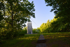
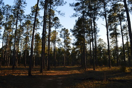
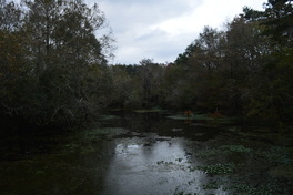
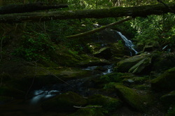
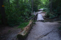
The Lake Russell trail system is often overlooked by hikers, who are interested in the "true" mountain hiking just a short drive to the north of Cornelia. The Lake Russell Recreation Area does not sit in the actual mountains, but these foothills provide quality hiking nonetheless. Several hiking trails can be found around Lake Russell and Nancytown Lake. On this hike, you will first see a couple of waterfalls on Nancytown Creek, before hiking along the shores of Nancytown Lake and then Russell Lake. The route becomes more difficult as the hike follows a seldom-used trail to the top of Chenocetah Mountain, where an old fire tower stands. Before your return to Nancytown Lake along a different trail, make sure to stop by the two clearings on Chenocetah Mountain that provide some views of Lake Russell and the distant Blue Ridge Mountains. This hike occurred on Saturday, May 7th, 2016. My plan was to hike several of the trails in the Lake Russell trail system. First, I would hike the Sourwood Trail. Then, I would take the Nancytown Lake Trail along the eastern shore of the lake, before connecting to the Lake Russell Loop and hiking the eastern and southern sides of the loop. From there, I would walk a short section of Lake Russell Road before taking the Campground Trail to the top of Chenocetah Mountain. I would return to Nancytown Lake using the Rhododendron Trail.
2 Comments
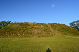
Kolomoki Mounds State Park is home to one of three large complexes of historical Indian mounds in Georgia. The park has the largest and oldest site in the Southeast that used to be occupied by the Woodland Indians. The park's tallest mound - known as the Temple Mound - rises 57 feet high. In addition to the mounds, the park has two lakes and several hiking trails that meander through hilly forest around the lakes. This hike occurred on Saturday, April 16, 2016. My plan was to hike the Temple Mound Trail to the Temple Mound and a couple of other small mounds next to it. Then, I would follow the White Oak Trail through mostly dry forest and across a pair of small streams back to the trailhead.
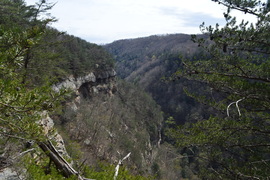
You have probably heard about Cloudland Canyon. Cloudland Canyon State Park's Sitton Gulch and Daniel Creek's waterfalls are known very well throughout the hiking community. The park's West Rim Trail is also known quite well. However, many hikers are not aware of another hiking trail in the park - and one that is much more secluded: the Bear Creek Backcountry Trail. The Bear Creek Trail passes through the Bear Creek gorge and then cruises over hills in the eastern section of the park, before reaching a fantastic vista of Cloudland Canyon. Unfortunately, as of March 21, 2016, the Bear Creek Backcountry Trail is closed east of Bear Creek indefinitely. This hike occurred on Saturday, March 19th, 2016. My plan was to check out the "tourist overlook" of Cloudland Canyon near the trailhead. From there, I would hike the Overlook Trail to the Bear Creek Backcountry Trail. Then, I would hike the entire Bear Creek Backcountry Trail - my plan was to hike the loop section counter-clockwise and then return the same way. On my way back, I planned to hike the park's Backcountry Loop clockwise.
729-foot Amicalola Falls is famous for being the highest waterfall in Georgia. Nestled in Amicalola Falls State Park, the falls attracts a crowd of tourists all throughout the year. A network of hiking trails and pathways is positioned around the falls and both to the west and east of it. For those seeking a more intimidating hike that relatively has some solitude, the park has two trails that head out into nearby Chattahoochee National Forest. The Hike Inn Trail leads to a lodge that is accessible only by foot five miles from the park, while the AT Approach Trail acts as the access trail to Springer Mountain - the southern terminus of the Appalachian Trail. You'll be treated to continuous winter views and several year-round viewpoints on both trails. This hike occurred on Saturday, March 4, 2016. My plan was to take the AT Approach Trail from the Visitor Center past Amicalola Falls and to the Hike Inn parking area and trailhead. From there, I would take the Hike Inn Trail to the Len Foote Hike Inn and then to the AT Approach Trail near Amicalola Mountain. Then, I would take the AT Approach Trail to Springer Mountain. I would return to the Hike Inn Trailhead using solely the AT Approach Trail. From the Hike In Trailhead, I would take East Ridge Trail to the Visitor Center.
 It's a rare occurrence to find a relatively major trail system in inland southern Georgia. The Georgia coastline features a number of parks and hiking trails, but as you head inland, there's very few preserved areas that you can find west of the Okefenokee Swamp. Georgia Veterans Memorial State Park is one of these few places. In this extensive state park located on the eastern shore of Lake Blackshear, explore several miles of trails along a finger of Lake Blackshear and through a longleaf pine forest. This hike occurred on Saturday, January 30, 2016. My plan was to hike the Lake Shore Trail and the Yucca Trace Trail. It appears that the trail map on the Georgia State Parks website is outdated, and there is a new Walk-in-the-Pines Trail. Thus, I was able to use this new trail to connect the other two trails.
 There's not many hiking trails across southern Georgia, as nearly all of the land is developed. There are several state parks such as Reed Bingham State Park that have short hiking trails showcasing the few wilder areas of southern Georgia. Reed Bingham State Park protects a several-mile section of the Little River with a small lake at the southern end. The park's hiking trails travel through uplands just east of Little River, with several sections of trail along the river. This hike occurred on Saturday, November 21st, 2015. My plan was to hike some of the Upland Loop to get onto the Little River Trail along Little River. I would return to the trailhead using Birdwalk Trail.
Franklin Delano Roosevelt State Park: Dowdell Knob Loop via Hines Gap Road, Pine Mountain, Georgia12/17/2015  The Pine Mountain Trail is a 23 mile trail that travels across the majority of Pine Mountain Range, an elevated tract of land located in southwest Georgia. The ridge is the southernmost area of land in the eastern US that is higher than 1000 feet above sea level, and in fact, the ridge's high point, Dowdell Knob, that this hike visits, is nearly 1400 feet high. The ridge stretches from Lake Harding on the AL/GA border to the Flint River near Thomaston. This hike occurred on Saturday, November 7, 2015. My plan was to follow the Pine Mountain Trail from Hines Gap Road over Dowdell Knob to the second junction with Boottop Trail. I would then return via the Boottop Trail.
 The Lookout Mountain Battlefield is a large tract of conserved land that covers the better portion of Lookout Mountain's slopes. The area that this tract covers is the site of the Battle of Lookout Mountain (a battle that was a part of the US Civil War's Chattanooga Campaign). The area is home to an assortment of interesting sights, most notably several rather large springs, as well as many important historic sights and even some good vistas. The mountain is crisscrossed by trails, and there are many ways to create long day hikes on Lookout Mountain. This hike occurred on October 10th, 2015. My plan was to hike to a number of features on the west side of Lookout Mountain: Skyuka Spring, Sunset Rock, and Gum Spring, but due to some confusing intersections, the total mileage of the hike had to be increased to the point that only Skyuka Spring was seen in the daylight. My plan was to start on the Kiddie Trail. I would then take the Skyuka Trail to Skyuka Spring, and follow the John Smartt Trail and later the Jackson Gap Trail to the Bluff Trail. The Bluff Trail would be followed to Sunset Rock, and then using the Gum Spring Trail and Lower Gum Spring Trail, I would return to the trailhead. As you'll see below, this plan didn't quite work out.
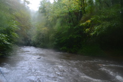
The Eastern Continental Divide is a geographically important mountain ridge that separates the waters of the Tennessee River from the waters of the Savannah River. When hiking the Hemp Top Trail, you'll be on top of this very ridge. Just to the west of the ridge, the Cohutta Mountains' most famous river, Jacks River, is a must-see after heavy rainfall in flood stage. Just don't try to ford it... even though I forded it several times on this day (it was in flood stage), it would be a risky procedure when the river is as high as it was on this day. This hike occurred on Saturday, October 3rd, 2015. My original plan was to hike the Penitentiary Loop - to first hike the Hemp Top Trail until the Penitentiary Branch Trail. I would then hike the Penitentiary Branch Trail. I would reach the Jacks River and follow the Jacks River Trail back to the trailhead, fording the Jacks River 18 times in the meantime. However, circumstances made me hike out and back to the Jacks River area at the end of Penitentiary Branch Trail.
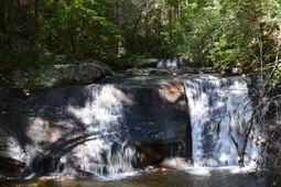
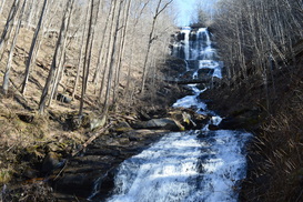
Emery Creek is a mountain stream located on the southern fringe of the Cohutta Mountains. The creek is full of waterfalls and cascades, with five waterfalls visible from near the trail and many more smaller cascades. To see all of the waterfalls on Emery Creek, you'll have to get a bit wet, with two dozen fords roundtrip, but it's worth it. Additionally, you can extend your hike to Little Bald Mountain, where in the winter, the views are extensive, and in the summer, the trail goes through whole fields of ferns. This hike occurred on Saturday, September 12th, 2015. My plan was to hike the Emery Creek Trail out and back from the southern terminus near Holly Creek to the northern terminus near Little Bald Mountain.
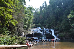
Panther Creek is a popular destination for folks all across north Georgia - in fact, you're unlikely to find solitude on weekends at Panther Creek Falls, the primary destination of most people who hike the Panther Creek Trail. However, what most hikers don't know about is that the full Panther Creek Trail is considerably more strenuous and longer; the trail doesn't just end at Panther Creek Falls. By hiking the full length of the Panther Creek Trail, you will experience a lot more solitude, see more of the creek's more turbulent stretches, and overcome a challenge - as hiking the east half of the Panther Creek Trail is a task that's not for the faint-hearted. This hike occurred on Saturday, September 5th, 2015. My plan was to hike the entire Panther Creek Trail from the eastern terminus near Yonah Dam to the western terminus at Old US Highway 441 and back.
Are you looking for a remote, scenic hike in the busy Atlanta metro area? The trail system at Sweetwater Creek State Park may be right for you. The park's constantly expanding trail system lies on both the west and east sides of beautiful Sweetwater Creek. You can explore the historic mill ruins and the numerous rapids on Sweetwater Creek, visit the historic farming area on Jack's Hill, or traverse the dry ridges on the east side of Sweetwater Creek. This hike was a partial redo of a previous hike of mine at Sweetwater Creek State Park. This hike occurred on August 29th, 2015. My plan was to hike the Red Trail to its southern terminus and then follow the White Trail over Jack's Hill and back to the trailhead.
Smithgall Woods State Park, one of the largest state parks in Georgia, is a low-elevation woodlands tract near the tourist town of Helen. Through the center of the park flows Dukes Creek.This hike revolves around Dukes Creek, visiting several waterfalls on tributaries as well as the main show, Dukes Creek Falls. This hike occurred on Saturday, August 8th, 2015. My plan was to hike the Laurel Ridge Trail clockwise, and then follow Tsalaki Trail (a paved road that is closed to vehicles) to several various trails: Wetlands Loop, Martin's Mine Trail, Cathy Ellis Trail, and Ash Creek Trail. After completing all of these trails, I would also head upstream along Dukes Creek and take the Dukes Creek Falls Access Trail to Dukes Creek Falls.
Springer Mountain is not any regular mountain. It's a special place. Springer Mountain is the southern terminus of the famous Appalachian Trail. Every year, thousands of hikers start a journey here that will last many months. Other hikers finish their long thru-hikes at this point, and when they reach the summit of the mountain, after hiking in from Three Forks, they've achieved an accomplishment. On this day hike, you'll feel almost like those southbound thru-hikers as you make the southernmost climb on the Appalachian to reach the first (or last) white blaze on the Appalachian Trail. You'll return using a lesser-traveled route using the alternative Benton Mackaye Trail. This hike occurred on Saturday, August 1st, 2015. My plan was to follow the Appalachian Trail from Three Forks to the summit of Springer Mountain. I would return back to Three Forks via the Benton Mackaye Trail.
Located in central Georgia, High Falls is the most impressive waterfall in the Georgia Piedmont. Located on the Towaliga River, this water feature is an unusual sight for area this far south. This short leg-stretcher is a good option, if you're travelling I-75. In addition, if you're looking for a longer hike, you can try some of the other trails in the park to add a few miles. This hike occurred on Thursday, June 25th, 2015. My plan was to do the quick walk to the falls and back from the parking area.
|
About MeMark Oleg Ozboyd Dear readers: I have invested a tremendous amount of time and effort in this website and the Georgia Waterfalls Database the past five years. All of the work that has gone in keeping these websites updated with my latest trip reports has almost been like a full-time job. This has not allowed me to pick up a paid job to save up money for college, and therefore, I I've had to take out loans. If you find the information on this website interesting, helpful, or time-saving, you can say "thanks" and help me out by clicking the button above and making a contribution. I will be very grateful for any amount of support you give, as all of it will apply toward my college tuition. Thank you!

Coming in 2022-2023?
Other Hiking WebsitesMiles HikedYear 1: 540.0 Miles
Year 2: 552.3 Miles Year 3: 518.4 Miles Year 4: 482.4 Miles Year 5: 259.9 Miles Archives
March 2021
Categories
All
|
 RSS Feed