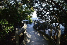
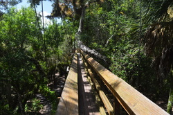
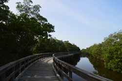
 The barrier island of Longboat Key is home to a series of upscale development along the Longboat Key beach, generally referred to as the town of Longboat Key. By now, nearly the entire island is developed with very few of the native salt marshes and mangrove jungles left. Joan M. Durante Park preserves one of the last wild spots on Longboat Key, a place where you can hike on easy nature trails through salt marshes to the mangrove-lined shores of Sarasota Bay. This hike occurred on Monday, November 23rd, 2015. My plan was to hike the largest loop of the nature trails in Joan M. Durante Park.
0 Comments
Florida Trail: Bell Springs to Robinson Branch Falls and Big Shoals, White Springs, Florida9/20/2015 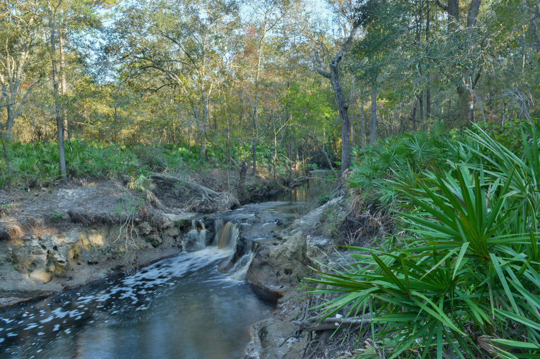
Have you ever wanted to see a waterfall in Florida? Here's your chance. The waterfall on this hike is not high at all, but it's interesting in other aspects, not to mention that it's pretty powerful. Besides the waterfall, you'll get to experience the beauty of the Suwanee River Valley. Additionally, the hike continues to an anomalous natural sight: one of only two Class III whitewater rapids in Florida. This hike occurred on Sunday, July 19th, 2015. My plan was to hike the Florida Trail from the trailhead at Bell Springs to at least Robinson Branch Falls. Depending on conditions, I wanted to visit the Big Shoals on the Suwannee River, but a deep-looking ford of Robinson Branch happened to be my turnaround point, as I didn't have the proper gear for fording at the time. On Saturday, November 4th, 2017, I returned to the Bell Springs section of the Florida Trail at a time of lower water conditions. This time, with proper gear for fording the creek, I hiked all the way to Big Shoals, and the trail report has been updated for the trail between Robinson Branch Falls and Big Shoals.
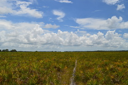
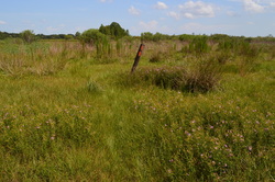
Once upon a time, the prairie was the key component of the nature of central Florida. Nowadays, not much of the prairie land is left, but fortunately, the majority of it is protected by tracts such as Myakka River State Park and Kissimmee Prairie State Park. On this long, strenuous (by Florida standards, of course) hike, you'll get to see the Florida prairie and the type of flora and fauna it is home to. However, you'll have to be sure that you bring sufficient water to enjoy this hike to its fullest. This hike occurred on Sunday, July 19th, 2015. My plan was to hike Fox's Low Road to the Myakka Hiking Trailhead. From here, I would do a large clockwise loop on the Myakka Hiking Trail. I would use Bobcat Crosstrail to shortcut the full 39-mile loop. I would end up back at the Myakka Hiking Trailhead at Fox's Low Road, and I would take Fox's Low Road back to the parking area.
Myakka River State Park is one of the largest state parks in Florida. Protecting a large section of the Myakka River watershed, including two lakes, this massive park has all kinds of outdoor recreational opportunities. Most importantly for us hikers is a 39-mile hiking only loop trail that is located in the center of the park. The park also has many miles of dirt roads suitable for both hiking and biking, and even a few nature trails, like this one. This hike occurred on July 19th, 2015. My plan was to hike the short nature trail clockwise. I would then move on to hiking half of the park's main hiking loop, although that hike will be described in a separate post.
Little Manatee River State Park: Little Manatee River/Cypress Creek Loop, Parrish, Florida8/27/2015 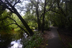
Close to the large Tampa metro area, this hike along the Little Manatee River showcases the beauty of Florida's rivers. Despite how short this hike is, you'll get to see a variety of ecosystems, including miniature palmetto prairies, swamps, and a river habitat. If you're lucky, you may spot an alligator in or near the river - although maybe that's not something you exactly want to wish for. This hike occurred on Wednesday, July 15th, 2015. My plan was to hike the main hiking loop in Little Manatee River State Park counter-clockwise. Along the way, I would also take the short spur trail to the primitive campsite.
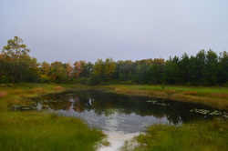
Lake June-in-Winter State Park: Bobcat Trail, Deer Trail, and Eagle Trail, Lake Placid, Florida8/24/2015 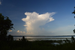 One of the larger lakes in the vicinity of the small town of Lake Placid, Lake June-in-Winter is home to a relatively new state park. Located on the western shore of the lake, the small park has several short trails that showcase the beauty of Lake Wales Ridge, although the condition of the park leaves something to be desired. Lake Wales Ridge is a low ridge that stretches through central Florida. This hike occurred on Sunday, July 12th, 2015. My plan was to hike the main loop in the park that consists of the Bobcat Trail, Deer Trail, and Eagle Trail, and then, time-permitting, to hike the short Tomoka Run Nature Trail.
The Kissimmee River is one of the largest rivers in Florida. In its large floodplain lies the route of the Florida Trail. The section of the Florida Trail that continues southeast from US Route 98 is known as the Chandler Slough section. The piece that I did on this day was overgrown and sometimes underwater. I eventually had to revise my plans, as this is one of those Florida hikes that is best done during winter. This hike occurred on Sunday, July 12th, 2015. My plan was to hike the Florida Trail from the Micco Landing Trailhead on US 98 to the Chandler Slough West Trailhead that is also on US 98. Unfortunately, I only did a short part of my plan due to the poor conditions of the trail.
The Ocala National Forest is home to the endangered sand scrub pine habitat. In the Ocala is the largest unbroken tract of this habitat in the world. This long but beautiful hike on the Florida Trail showcases the beauty of the sand scrub pine habitat and the vast prairies that surround it. On this excursion, you will also see Hidden Pond, a small pond in the middle of the prairie land, and you will see the Long Cemetery, a small, old cemetery located on the historic Yearling Trail. This hike occurred on Sunday, July 5th, 2015. My plan was to hike the Florida Trail from the trailhead on Florida State Route 40 to the junction with the Yearling Trail 10 miles later. From there, I would take the Yearling Trail to the Long Cemetery. I would return the same way.
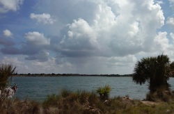
The salt marshes that dot the regions near the ocean can be some of the most scenic environments for hiking in Florida. On this hike, you can escape the urban feelings of the city of Bradenton for an afternoon walk in a relatively little-known preserve just outside of the city limits. On this hike, you'll traverse many miles of salt marshes, travel to the shoreline of Tampa Bay, and climb up an observation tower to a sweeping vista of Tampa Bay and the surrounding salt marshes. This hike occurred on Wednesday, July 1st, 2015. My plan was to hike the Osprey Loop counter-clockwise. Along the way, I would take the spur trail to the Manatee Overlook observation tower, as well as Tern Trail and Gull Trail. If I would have any leftover time, I would also take the Spoonbill Trail to the Ibis Trail and take the short Ibis Trail to a view of Perico Bayou.
Florida hiking is unlike any hiking in the mountains. Instead of mountain vistas, most of the time you're looking for prairies; instead of waterfalls, with a few notable exceptions, you are looking for lakes and springs. This was my first Florida hike ever, and I was impressed. The bright blue lakes of Weeki Wachee Preserve provide excellent scenery on this hike. In addition, you can extend your hike into a bear habitat with the chance to see some wildlife or their traces. This hike occurred on Sunday, June 28th, 2015. My plan was to at least hike the main loop in the preserve (all on old jeep roads). I would first take Burnt Road, and then turn onto Loop Road and follow the western shorelines of the lakes. After crossing between two lakes, I would take South Lake Road to the second entrance to the preserve. From here, I would follow the paved road (which is open to vehicles only on the 2nd and 4th Saturday of every month) to the trailhead for Burnt Road, and I would follow Burnt Road back to the parking area. Depending on the conditions by the end of the hike, I also had the option of doing an out-and-back hike along Bear Claw Road.
|
About MeMark Oleg Ozboyd Dear readers: I have invested a tremendous amount of time and effort in this website and the Georgia Waterfalls Database the past five years. All of the work that has gone in keeping these websites updated with my latest trip reports has almost been like a full-time job. This has not allowed me to pick up a paid job to save up money for college, and therefore, I I've had to take out loans. If you find the information on this website interesting, helpful, or time-saving, you can say "thanks" and help me out by clicking the button above and making a contribution. I will be very grateful for any amount of support you give, as all of it will apply toward my college tuition. Thank you!

Coming in 2022-2023?
Other Hiking WebsitesMiles HikedYear 1: 540.0 Miles
Year 2: 552.3 Miles Year 3: 518.4 Miles Year 4: 482.4 Miles Year 5: 259.9 Miles Archives
March 2021
Categories
All
|
 RSS Feed