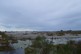
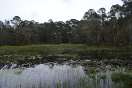
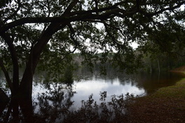
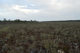
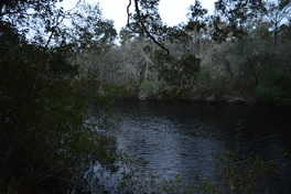
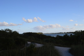
 One of two primitive trails at St. Marks National Wildlife Refuge, the Stoney Bayou Loop follows several old forest roads through several different ecosystems, including pine flatwoods, a cypress swamp, and an open marsh. On this hike, you will get the chance to see an alligator or two, and you will be presented with good birding opportunities near the open marshes. To top of this excellent hike, you will have a vista of Stoney Bayou Loop #1, a large lake that touches the trail. This hike occurred on Friday, January 1st, 2016. My plan was to hike five nature trails at St. Marks National Wildlife Refuge on this day, as well as one of the primitive trails. This was my final stop of the day, and I was going to hike the Stoney Bayou Loop, a primitive trail, clockwise.
2 Comments
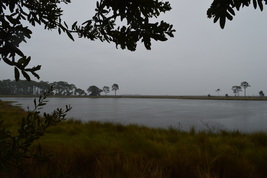
 The St. Marks Lighthouse is the second oldest lighthouse in Florida. The lighthouse marks the mouth of the St. Marks River. The town of St. Marks just to the northwest used to be an important port back in the early 1800s. In 1831, construction of the St. Marks Lighthouse was completed to help guide boats to the port at St. Marks. On the Lighthouse Levee Trail, you will travel along a dike near Lighthouse Pond to a promontory extending out into the Gulf of Mexico, before reaching the historic St. Marks Lighthouse. This hike occurred on Friday, January 1st, 2016. My plan was to hike five nature trails at St. Marks National Wildlife Refuge on this day, as well as one of the primitive trails. I was planning to hike the Lighthouse Levee Nature Trail out and back from the boat ramp parking to the historic lighthouse.
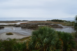
 A relatively new nature trail at St. Marks National Wildlife Refuge, the Cedar Point Trail follows a dike between a salt marsh and a dredged boating channel to a wild location where the waves of the Gulf of Mexico hit a pristine shoreline. This hike occurred on Friday, January 1st, 2016. My plan was to hike five nature trails at St. Marks National Wildlife Refuge on this day, as well as one of the primitive trails. This trail was my third stop of the day. Each trail just kept getting better - there are beautiful views to be seen from the Cedar Point Trail, despite its short length. My plan was to hike the trail out and back.
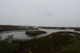
 Tower Pond and Headquarters Pond are two small ponds in the southern section of the St. Marks Unit of St. Marks NWR. Two nature trails visit these ponds. On the Tower Pond Nature Trail, you will visit an old fire tower before circling Tower Pond via a number of paths and forest roads. You will also see some salt marshes. Along the way, don't miss the photo blind for great birding opportunities. On the shorter Headquarters Pond Trail, which leaves the same trailhead, you will take a quick walk to an observation platform overlooking Headquarters Pond, a small body of water full of lily pads. If you're lucky, you might even spot an alligator. This hike occurred on Friday, January 1st, 2016. My plan was to hike five nature trails at St. Marks National Wildlife Refuge on this day, as well as one of the primitive trails. These two trails were my second stop of the day, after the Plum Orchard Nature Trail. I planned to hike the Tower Pond Trail clockwise, and then, I would hike the Headquarters Pond Trail out and back.
 One of the shortest nature trails at St. Marks National Wildlife Refuge, Plum Orchard Nature Trail packs several interesting sights in its 0.7 miles, including a small pond that is good for birding, a boardwalk across a marsh, and a dense corridor of saw palmetto. This hike occurred on Friday, January 1st, 2016. My plan was to hike five nature trails at St. Marks National Wildlife Refuge on this day, as well as one of the primitive trails. The Plum Orchard Nature Trail was the first nature trail I hiked on this day. My plan was to hike the short loop clockwise.
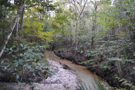
 Coming in at over 600,000 acres, Apalachicola National Forest is Florida's largest national forest - it is the home to the famed Bradwell Bay Wilderness, one of the wildest swamps in Florida. While the forest may be best-known for the large swamp expanse of Bradwell Bay, it is also home to an uncommon sight - numerous pitcher plant bogs scattered throughout the area. One particular hiking trail, the Wright Lake Loop, visits several of these pitcher plant bogs in the western section of the forest that are easy to get to. However, after a month of historical rains, they may not be quite so easy to get to. This hike occurred on Thursday, December 31, 2015. My plan was to hike the entire Wright Lake Loop, but due to impassable sections of trail with pretty severe flooding ongoing in all of the nearby creeks, I was forced to abandon my plan and hike merely a small segment of the Wright Lake Loop.
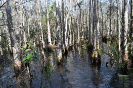
 Located along Florida's Gulf Coast, Tate's Hell State Forest is one of Florida's largest state forests - and one of its wildest. Tate's Hell State Forest is home to several dwarf cypress swamps, one of the most bizarre sights to be seen in Florida. On this short boardwalk, you will get a chance to see one of the largest dwarf cypress swamps in Tate's Hell, where none of the cypress trees are taller than 15 feet, and some are over 300 years old. This hike occurred on Tuesday, December 29th, 2015. My plan was to follow the Ralph G. Kendrick Dwarf Cypress Boardwalk out and back to an observation area overlooking the dwarf cypress swamp.
 The Sopchoppy River is a minor river that originates in the Apalachicola National Forest in Florida's Big Bend region. On its way south to the Gulf of Mexico, it flows into the Ochlockonee River and becomes part of an important estuary network at Ochlockonee Bay. The small, historic town of Sopchoppy, based in 1894 and currently with a population of less than 500 people, sits on the banks of the Sopchoppy River. The town's park does not amount to much when one thinks of hiking trails, but its short nature trail leads to and along the river, allowing visitors to see the blackwater river and the habitats found along it up-close. This hike occurred on Monday, December 28th, 2015. My plan was to simply hike the short nature trail from the Sopchoppy City Park to some views of the Sopchoppy River.
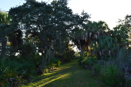
 The city of Gainesville has a lot of preserves with short nature trails that uncover the urban beauty found in the city. Gainesville's first nature preserve, 21-acre Alfred A. Ring Park, has a short trail with views of the pretty Hogtown Creek ravine that is uncommon in central Florida's flat landscape. Throughout this short hike, you will travel across hills and boardwalks exploring the creek valley. Go in the spring, and you may even spot some wildflower such as Solomon's seal. This hike occurred on Sunday, November 29th, 2015. My plan was to hike the trail along Hogtown Creek out and back, returning via the playground and garden.
 Protecting over 2000 acres of land along and near Old Tampa Bay, this park is an important preserve of one of the few natural habitats along Tampa Bay, where most of the shoreline is now developed and the native ecosystems are gone. The park has three trails that explore different ecosystems near the bay. The Otter Trail is the park's longest trail - it explores upland forest near an estuarine creek known as Double Branch Creek. This hike occurred on Saturday, November 28th, 2015. My plan was to hike the Otter Trail clockwise. This was the third and final trail in the park that I hiked on this day.
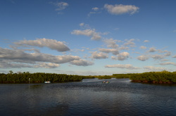 Protecting over 2000 acres of land along and near Old Tampa Bay, this park is an important preserve of one of the few natural habitats along Tampa Bay, where most of the shoreline is now developed and the native ecosystems are gone. The park has three trails that explore different ecosystems near the bay. On this short trail, you'll get to see some of the salt marshes and marl prairies that are found along this section of Old Tampa Bay. You'll also take a close look at Double Branch Creek, an estuary near Old Tampa Bay. This hike occurred on Saturday, November 28th, 2015. My plan was to hike the Bobcat Trail counter-clockwise. This would be the second out of three trails in the park that I hiked on this day.
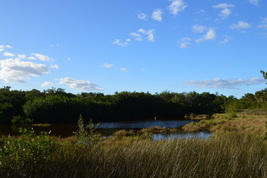 Protecting over 2000 acres of land along and near Old Tampa Bay, this park is an important preserve of one of the few natural habitats along Tampa Bay, where most of the shoreline is now developed and the native ecosystems are gone. On a short half-mile trail in the park, you can explore some of Old Tampa Bay's native salt marshes and get a view of the bay itself. This hike occurred on Saturday, November 28th, 2015. My plan was to hike the Eagle Trail out and back to a view of Upper Tampa Bay. I would then hike two other short trails in the park - they are described separately.
 At the southern tip of Anna Maria Island lies the small island known as Leffis Key. This location is one of the few undeveloped areas on Anna Maria Island. Leffis Key has been the center of restoration efforts to restore the area's natural habitats, such as the mangroves and salt marshes. On this hike, you'll see some of the results of the restoration efforts, and you'll walk to a number of vistas of Sarasota Bay. This hike occurred on Friday, November 27th, 2015. My plan was to hike the largest loop in the preserve with a side trip to the top of the hill on Leffis Key.
 You have probably wanted to see the famous swamp network known as the Everglades... from the safety of a wide, dry boardwalk. But have you wanted to see this enormous, wild swamp the hard way? Collier-Seminole State Park, on the western edge of the Everglades, protects a section of the swamp where black bears and Florida panthers abound. The primary focus on hiking in the park is the "Adventure Trail", a nearly 7-mile long slog across the dark swamp waters into one of Florida's most remote areas. This hike occurred on Thursday, November 26th, 2015 (Thanksgiving Day). My plan was to hike the Adventure Hiking Trail loop counter-clockwise, although by the time I was 2/3 of the way through, I was confident that the opposite direction would've been better.
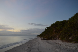 In southwest Florida, there's very few beaches left that are not developed, but thanks to conservation efforts, a few wild strips of beach remain. One of them is Caspersen Beach, a several-mile long section of preserved, wild beach near Venice. The small, linear county park that protects the beach also has a couple of nature trails that lead to and along the Intracoastal Waterway. This hike occurred on Tuesday, November 24th, 2015. My plan was to hike the short nature trail to the Intracoastal Waterway and near the beach. I would then hike the old road/trail that follows the strip of land between the beach and the Intracoastal Waterway to the southern boundary of the park. I would return via Caspersen Beach.
|
About MeMark Oleg Ozboyd Dear readers: I have invested a tremendous amount of time and effort in this website and the Georgia Waterfalls Database the past five years. All of the work that has gone in keeping these websites updated with my latest trip reports has almost been like a full-time job. This has not allowed me to pick up a paid job to save up money for college, and therefore, I I've had to take out loans. If you find the information on this website interesting, helpful, or time-saving, you can say "thanks" and help me out by clicking the button above and making a contribution. I will be very grateful for any amount of support you give, as all of it will apply toward my college tuition. Thank you!

Coming in 2022-2023?
Other Hiking WebsitesMiles HikedYear 1: 540.0 Miles
Year 2: 552.3 Miles Year 3: 518.4 Miles Year 4: 482.4 Miles Year 5: 259.9 Miles Archives
March 2021
Categories
All
|
 RSS Feed