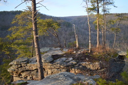
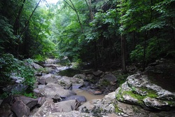
 The Three Gorges segment of the Cumberland Trail is a very beautiful area, part of the Bowater Paper Company's former lands. The three main gorges on this segment of the Cumberland Trail get better in succession from south to north. It starts with the Soddy Creek Gorges, which are the only ones I haven't visited yet on this section (although I heard that they are not very interesting with few attractions). Just to the north, the Possum Creek Gorges are considerably more scenic, with more waterfalls and a few small views. The best of the three is Rock Creek Gorge, described in this post. The Rock Creek Gorge is full of pristine wilderness with many small cascades and outstanding views of the gorge from multiple viewpoints on the east rim. This hike occurred on Saturday, December 20th, 2014. My plan was starting from the Retro-Hughes Trailhead to hike the Cumberland Trail north into the Rock Creek Gorge. Once I would get to the end of the current Cumberland Trail section here, I would complete the short Rock Creek Loop with the side trip to the outstanding views from Leggett Point, then return the way I came on the Cumberland Trail.
13 Comments
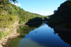
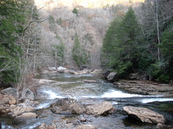 The Southern Cumberland Plateau is an incredibly scenic area. There's dozens of scenic gorges, full of waterfalls and rugged cliffs. North Chickamauga Creek Gorge is one of my ultimate favorites in this area after doing this hike. The rugged mountain streams in this gorge have beautiful waters, the gorge floor is incredibly beautiful, and the views of the upper section of the gorge are.... simply amazing. This hike occurred on Saturday, November 22nd, 2014. My plan was to start this hike from the gate at the end of the open Barker Camp Road, and follow Barker Camp Road on foot to the old turnaround. From there, I would follow an old jeep road to the Cumberland Trail, and take the Cumberland Trail south into North Chickamauga Creek Gorge. Before plunging into the gorge, I would stop at Panther Creek Overlook. Once in the gorge, I would ford Cooper Creek and reach the destination at Stevenson Branch Falls. My original destination was Boston Branch Overlook, but by seeing how much time it took to reach Stevenson Branch Falls, and seeing the deteriorating nature of the trail after Stevenson Branch Falls, I had to cut my plans by some.
 Big Frog Mountain is the highest mountain in southeastern Tennessee, topping out at over 4000 feet. The mountain and surrounding areas are protected by the combined Cohutta - Big Frog Wilderness. The newest addition to the area, though, is the Little Frog Wilderness, a smaller tract of land across from Big Frog Wilderness and US Highway 64. This tract protects the Panther Knob area, the better portion of Dry Pond Lead, and Rock Creek/Pressley Cove. Two trails, the Dry Pond Lead Trail and the Rock Creek Trail, provide access to the wilderness area, and you won't regret hiking them. This hike occurred on November 15th, 2014. My plan was to hike through most of the Little Frog Wilderness by starting at the Rock Creek Trailhead and hiking the entire Rock Creek Trail to the junction with the Dry Pond Lead Trail/Benton Mackaye Trail. Here, I would turn south onto the Dry Pond Lead Trail and follow it to US-64 and Ocoee Powerhouse No. 3. Then, I would enter the Tanasi Trail System, and take the Thunder Rock Express Trail to the Chestnut Mountain Trail. Next, I would follow the Chestnut Mountain Trail east, before exiting onto the Bear Paw Paw Trail that would lead down to Ocoee Whitewater Center. I would close the loop by hitchhiking 0.8 miles of US-64 to Rock Creek Trailhead (something I wouldn't recommend you to do!).
 Polk County, Tennessee, is the Gateway to the Cherokee National Forest. In this beautiful corner of extreme southeast Tennessee, the rivers cut their way through valleys, bordered by the low-lying peaks of the Unicoi Mountains. The Benton Mackaye Trail's route goes straight through the area, following rolling hills and wooded slopes. One of the more prominent landmarks in the area is called Buck Bald, a small mountain with the summit being nothing more than a grassy clearing accessible via Buck Bald Road. While the BMT doesn't directly go over the top, it passes close by, and access to the bald is easy. This hike occurred on Saturday, October 25th, 2014. My plan was from Highway 68 to follow the Benton Mackaye Trail north to Buck Bald Road, and then take Buck Bald Road to the summit of Buck Bald. This short hike is an excellent way to spend your afternoon and watch the sunset.
Great Smoky Mountains National Park: Mount LeConte via Alum Cave Trail, Gatlinburg, Tennessee11/3/2014 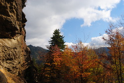 Mount LeConte is one of the most famous mountains in the Southeast. 3rd highest in the Great Smoky Mountains, it has as many as five access trails to the summit. I have done only one, but it is beautiful. Along the way up to LeConte, pass Arch Rock - an arch formed by water over the course of millions of years, and Alum Cave Bluffs - a huge rock overhang of Anakeesta Rock. Also, see the red squirrels, unique to the Southeast, that are found in this area. Near the summit, visit Mount LeConte Lodge and spend the night in the romantic-based lodge or cabins, or if you're like me, squeeze it all in a day hike. It's not that hard. This hike occurred on Saturday, October 18th, 2014. My plan was starting at the Alum Cave Bluffs Trailhead to follow the Alum Cave Trail all the way to the summit of Mt. LeConte. Then, I would visit Cliff Tops, Myrtle Point, and High Point. However, my plans did not include an excellent day changing to wind, fog, and drizzle.
 The Caney Fork River starts off in the Cumberland Mountains of Northern Tennessee. On its way to the Cumberland River and eventually Tennessee River, it passes through Scotts Gulf, as you might know, if you have followed this blog for a bit. I have hiked in Scotts Gulf before. Leaving Scotts Gulf, the Caney Fork widens on its way to Nashville. Rock Island State Park protects a rugged gorge in an otherwise mostly flat area. Here, the Rocky River flows into the Collins River, right before the Collins River flows into the lake-like Caney Fork River. Further downstream, you'll find a powerhouse and Great Falls Dam - the source of the lake. However, perhaps the biggest beauty of the park is a unique, one of a kind waterfall. Twin Falls flows out of a cave system, and drops into the Caney Fork. This hike occurred on Saturday, September 25th, 2014. My plan was to hike a few trails across the park, encompassing the best features. Each trail is listed below with a small description.
Virgin Falls State Natural Area: Virgin Falls Trail and Caney Fork River Trail, Sparta, Tennessee8/29/2014  The Caney Fork River's sources are in the northern Cumberland Plateau. On its way to the Tennesee River, it cuts a dramatic gorge known as "Scotts Gulf" near Sparta, TN. The Bridgestone-Firestone Centennial Wilderness protects Scotts Gulf, and an additional tract of land is Virgin Falls State Natural Area. Virgin Falls State Natural Area protects a number of features, with the key feature known as Virgin Falls. The 110-foot high cataract is very rare - it flows out of a cave and disappears int a pit in the ground that leads into an underground cave system. Additionally, Virgin Falls State Natural Area encompasses two more, smaller waterfalls, and a great overlook of Scott's Gulf itself. This hike occurred on Saturday, August 9, 2014. My plan was to do a loop hike with the Virgin Falls Trail, Caney Fork River Trail, and a Connector leading back up to Scott's Gulf Road. Also, on the way, I would check out Sheep Cave, Big Laurel Falls, Big Branch Falls, and Martha's Pretty Point Overlook. However, the plan had to be abandoned as the Caney Fork River Trail's condition deteriorated rapidly. The result was an out and back hike on Virgin Falls Trail and an extension along the Caney Fork River Trail.
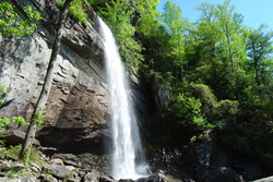
 The Fiery Gizzard Trail is one of the most beautiful and diverse trails in the state of Tennessee. Also, Backpacker Magazine lists it in the top 25 trails in the US. The nature in this part of the South Cumberland Plateau is beautiful. The Fiery Gizzard Trail starts on the southern edge of the city limits of Tracy City, and travels for 12 miles through rugged canyons in the Fiery Gizzard Creek watershed to Foster Falls Day Use Area. Foster Falls, a 60-foot single drop waterfall, makes for an exciting end to the trail. This hike occurred on Saturday, August 2nd, 2014. Starting the hike in the Foster Falls Day Use Area, I first checked out the Foster Falls Overlook. Then, I took the Fiery Gizzard Trail to pass above Foster Falls, and continued all the way to Laurel Gorge Overlook. My original plan was to stop here, but I decided to continue and make the rugged descent into the Laurel Branch Gorge. Then, I retraced my steps all the way back to the Climbers Access 2 to the Climbers Access Trail. This rugged trail descends down to Little Gizzard Creek and crosses just below Foster Falls on a swinging bridge, before ascending to the top of the rim and ending at the parking area.
 There's an assortment of waterfalls throughout the Smokies. Waterfalls aren't really my thing, but there are exceptions to that. Ramsey Cascades is the tallest waterfall in the park that is accessed by trail. Mill Creek Falls is slightly taller, but accessible by off-trail means only. Ramsey Cascades is around a hundred feet high, but what makes this waterfall more unusual than other is that it is not a "single drop waterfall", but rather, water cascading straight down a number of rock ledges. Not only is the destination of this hike rewarding, but the trail is too. On the trail, you will cross Ramsey Prong several times, as well as pass through an old-growth forest that contains some of the largest trees in the park. This hike occurred on Saturday, June 28, 2014. My plan was to follow the Ramsey Cascades Trail to Ramsey Cascades, and return the same way, since there were no other ways to return from the waterfall.
 The Cumberland Trail. It's a beautiful trail, and the more I hike it, the more I like it. The Cumberland Plateau is the southern section of the Appalachian Plateau, and it covers Eastern Kentucky, Central Tennessee, portions of Northeast/Central Alabama, and a small portion of Northwest Georgia. The Plateau is littered with many sandstone outcroppings and bluffs, which in my opinion, give the Cumberland Plateau its characteristics. The Cumberland Trail, when it will be finished, will follow the eastern rim of the plateau known as Walden Ridge throughout Tennessee. The trail begins at Signal Point near Signal Mountain, Tennessee and ends at Cumberland Gap National Historic Park near Cumberland Gap, Kentucky. While many of its sections are under construction or even not planned out, it still provides great section hiking opportunities, and remains one of my personally more favorite long distance hiking trails. While the AT (Appalachian Trail) is much more grand from most hikers' point of view, the lesser traveled CT is in no way less attractive, and in some cases, rivals the AT. This hike occurred on Saturday, June 21st, 2014. My plan was to start at the Cumberland Trail parking pullout on Heiss Mountain Road near TN State Route 111, and to follow the CT through the Blanchard Creek Gorge. Following that, I would ascend to Bare Point, and then descend into the Big Possum Creek Gorge, only to ascend to Perkins Point. From Perkins Point, I would descend into the Little Possum Creek Gorge before reaching Imodium Falls. I would return the same way.
Great Smoky Mountains National Park: Gregory Bald via Gregory Ridge Trail, Townsend, Tennessee6/10/2014 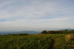 The Great Smoky Mountains National Park in East Tennessee/West North Carolina is an incredible diversity of wildlife, not to speak of the incredible hiking opportunities. I've been to the Smokies a handful of times, and one of my favorite experiences was Chimney Tops on Newfound Gap Road. However, this is only the second time I've been to the Smokies before I started the blog where I am writing at. Gregory Bald is most famous for the flame azalea that blooms in early to mid June on its summit. In addition, Gregory Bald has a 2 acre grassy area at the top (hence the name "bald"), and the views are pretty much 360 degrees. My main problem on this hike was summer haze limiting the views somewhat, but it was still beautiful. This hike occurred on Saturday, June 7th, 2014. My plan was to hike the Gregory Ridge Trail from the end of Forge Creek Road to Rich Gap. Rich Gap is where the Appalachian Trail used to pass through before it was rerouted. From Rich Gap, my plan was to turn right onto the Gregory Bald Trail and follow it to the summit of Gregory Bald. I would return the same way to the trailhead.
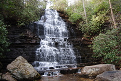
 The Cumberland Trail is a beautiful trail. While it is not fully completed yet, each of its sections is quite beautiful, and I enjoy each of my hikes along the trail. The Cumberland Trail follows the Cumberland Plateau in Central Tennessee, and it has both waterfalls and scenic views. The unique geography of the Cumberland Plateau always makes the hikes interesting. There are dozens of small but steep gorges, and there's rocks everywhere. This hike occured on Saturday, May 3rd, 2014. My plan was to hike a portion of the Cumberland Trail in the Laurel-Snow Pocket Wilderness. I planned visiting Laurel Falls and Bryan Overlook, and then go up the opposite side of the gorge to Buzzard Point Overlook. While there were a couple unexpected things throughout the hike, my plan got fulfilled.
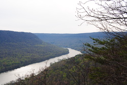 The Cumberland Trail is a state trail of Tennessee. It runs around 300 miles from its southern terminus at Signal Mountain, TN, to its northern terminus at Cumberland Gap, TN. It is not fully completed yet, but a lot of sections are open. It passes over the Cumberland Plateau of Tennessee, and is a very beautiful trail. I hope to hike many sections of it in the future. One of the most beautiful sections of it was the Tennessee River Gorge, my destination for this hike. This hike occurred on Saturday, April 5th, 2014. My plan was to hike the Cumberland Trail from its southern terminus at Signal Point Overlook to Edwards Point Overlook, and then return the same way.
 In the Ocoee District of the Southern Cherokee National Forest in Tennessee is the Ocoee River. It is surrounded by the mountains of the Chillhowee Ridge to its north, and the Cohutta Mountains to its south. While the Chillowhee Mountains are not high at all, just above 2000 feet, it was still rather attractive to check out some of the 20+ miles of trails in the Chillhowee Recreation Area. Benton Falls is the key attraction in the area, as Clear Creek tumbles 65 feet down a natural rock ledge. This hike occurred on Saturday, March 15th, 2014. My plans were to park at the Gazebo Overlook trailhead on Oswald Dome Road, to take the Gazebo Trail to McKamy Lake, then take Benton Falls Trail to Benton Falls, followed by Clemmer Trail to Rim Rock Trail, then take Rim Rock Trail to Clear Creek Trail, and finally use Clear Creek Trail to get back to the trailhead.
|
About MeMark Oleg Ozboyd Dear readers: I have invested a tremendous amount of time and effort in this website and the Georgia Waterfalls Database the past five years. All of the work that has gone in keeping these websites updated with my latest trip reports has almost been like a full-time job. This has not allowed me to pick up a paid job to save up money for college, and therefore, I I've had to take out loans. If you find the information on this website interesting, helpful, or time-saving, you can say "thanks" and help me out by clicking the button above and making a contribution. I will be very grateful for any amount of support you give, as all of it will apply toward my college tuition. Thank you!

Coming in 2022-2023?
Other Hiking WebsitesMiles HikedYear 1: 540.0 Miles
Year 2: 552.3 Miles Year 3: 518.4 Miles Year 4: 482.4 Miles Year 5: 259.9 Miles Archives
March 2021
Categories
All
|
 RSS Feed