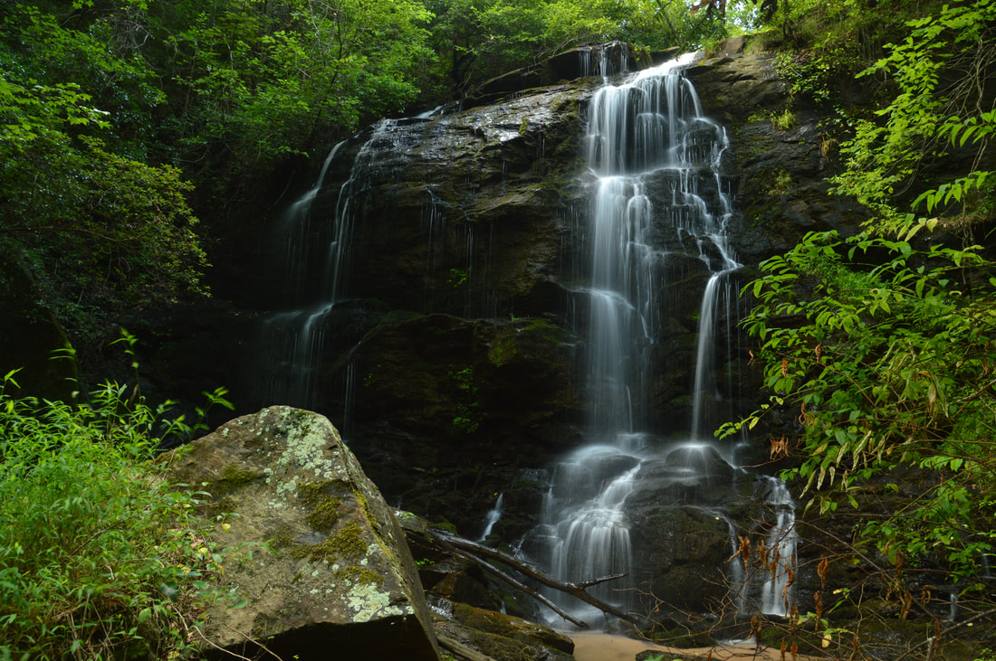
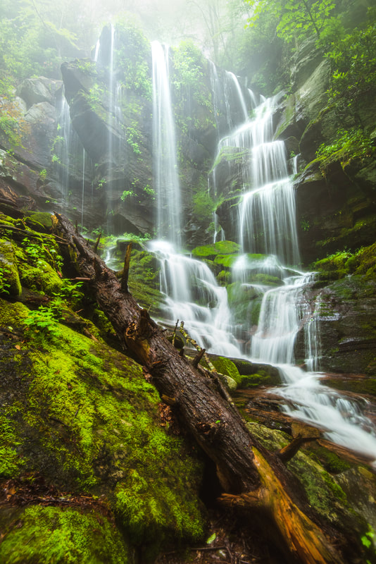
Mill Creek is one of the most scenic small streams in the Cohutta Mountains of Northwest Georgia. In a little more than a half-mile, the creek comes over four waterfalls and many smaller cascades, and an easy unofficial trail follows the creek with access to all of the gorgeous scenery. The third and largest waterfall, in particular, is a beautiful steep slide that drops over 30 feet into a sparkling pool. The last part of the trail is a steep scramble to the base of the third falls, but it still definitely is doable to most folks and well worth the effort. This hike occurred on Saturday, September 16th, 2017. My plan was to hike the Mill Creek Trail out and back from Hickey Gap Campground past the 1st Falls and 2nd Falls to the 3rd Falls on Mill Creek. I would also make a short creek scramble to the 4th Falls from the 3rd Falls.
1 Comment
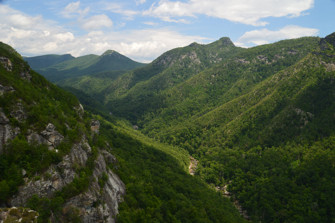
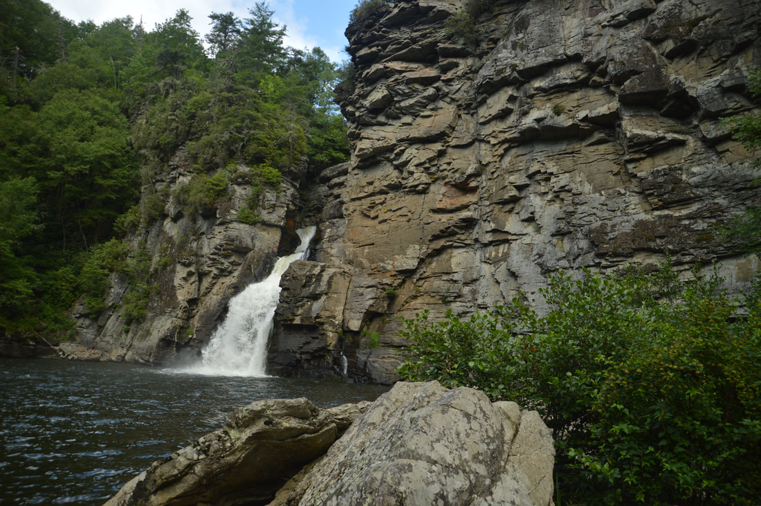
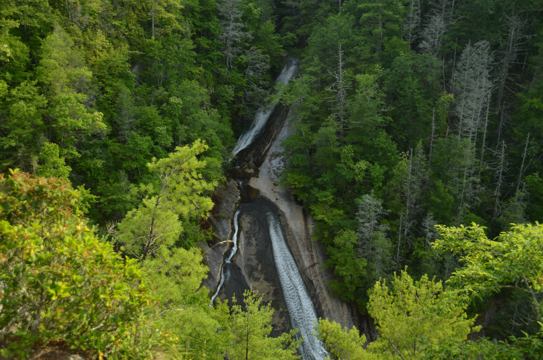
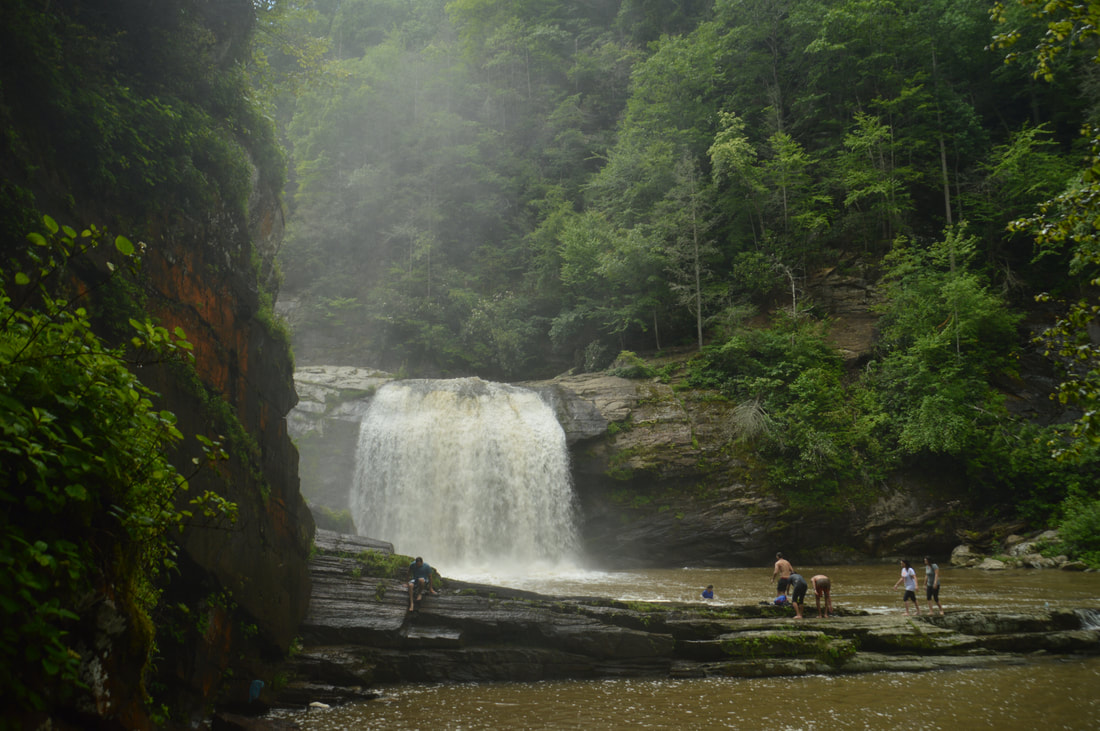
The Whitewater River is one of the most spectacular rivers in the Southeastern US. In its 15-mile length, the river plummets over two of the region's tallest and most breathtaking waterfalls, through a rare narrow slot canyon, and over nearly a dozen smaller waterfalls. Most folks familiar with the Whitewater River only know about Upper & Lower Whitewater Falls. This report focuses on the area immediately upstream, known as the Upper Whitewater River area, which is one of the most rugged, pristine, and gorgeous stretches of river that I've hiked. The Upper Whitewater Slot Canyon is a particularly unique location, where the mighty Whitewater River squeezes into a narrow canyon about 300 feet long and only a feet wide, lined by sheer cliffs rising dozens of feet. The river even crashes over two significant waterfalls - Sculpted Falls & Little Canyon Falls - in the canyon, as well as two others - Entrance Falls and Exit Falls - at both ends of it. While the waterfalls around the canyon are this hike's biggest highlight, many other photogenic waterfalls such as 55 MPH Falls lie between the canyon and Route 281, and the scenic Hornet Falls on Democrat Creek, a Whitewater River tributary, is a great bonus too. Seeing all of the waterfalls along the Upper Whitewater River requires a cross-country trek about as challenging as any in the North Carolina mountains, although access to a few selected waterfalls by themselves is easier. This hike occurred on Saturday, September 9th, 2017. Placing one car at NC 281 and another on Heady Mountain Road, my plan was to follow the easiest route downstream along the Whitewater River between the two parking areas, making sure to visit all waterfalls on the river as well as Hornet Falls on Democrat Creek.
The beauty of the Conasauga River's rushing waters attracts many hikers and campers to the west side of the Cohutta Wilderness. Every single trail in this part of the wilderness crosses and follows the Conasauga at some point, but no other trail is as notable as the Conasauga River Trail. This trail follows its namesake river for nearly a dozen miles, as it gradually grows from a small rivulet at the headwaters area near Betty Gap to a wide boulder-strewn river lined by cliffs and full of swift rapids below the confluences of Rough Creek, Thomas Creek, and Hickory Creek. A whopping 38 fords of the Conasauga River - some of which are up to waist-deep - make this a fairly challenging aqua-hike, but those who choose to shuttle the full trail will be rewarded by countless scenic cascades and small waterfalls. An out-and-back hike from either end of the trail is worthwhile as well, as beautiful water features are scattered evenly throughout the river. This hike occurred on Saturday, September 2nd, 2017. My plan was to hike the Conasauga River Trail from its southern trailhead at Betty Gap on FS 64 to its northern trailhead at FS 17B. I arranged to have two cars for this point-to-point hike: one at FS 64 and the other at FS 17B.
The Jacks River is known best for its spectacular huge waterfall Jacks River Falls, but much further upstream is another waterfall that is much smaller and less-known but still quite scenic: Shadow Falls. Located on the South Fork of the Jacks River, 20-foot Shadow Falls is easily accessible via the South Fork Trail. The waterfall is situated between two knobs near Jacks River Fields Campground in an area of the Jacks River watershed that otherwise has only gradual elevation loss along the course of the river. If you choose to turn the short waterfall hike into a much longer day hike or overnight, a few historic features around Flat Top Mountain await. In addition, you'll find plenty of solitude on the little-used trails on this hike, perhaps with an exception around Shadow Falls and Jacks River Fields. This hike occurred on Saturday, August 26th, 2017. My plan was to hike the South Fork Trail from the trailhead near Elliot Road, shortly joining the Benton Mackaye Trail, south to Shadow Falls and the small lower waterfall. From there, I'd hike the Benton Mackaye Trail to Flat Top Mountain, where there is a historic homestead and the foundations of an old fire tower. I would also make a side trip to the historic Dyer Cemetery along the way. I would then return along the BMT to FS Road 64 and follow FS 64 West past Jacks River Fields Campground to Buddy Cove Gap. I would conclude the hike by following the Pinhoti Trail northward back to South Fork Trail and Elliot Road.
Chattahoochee National Forest: Big Thunder Falls & Canyon on Clear Creek, Sky Valley, Georgia8/29/2017 
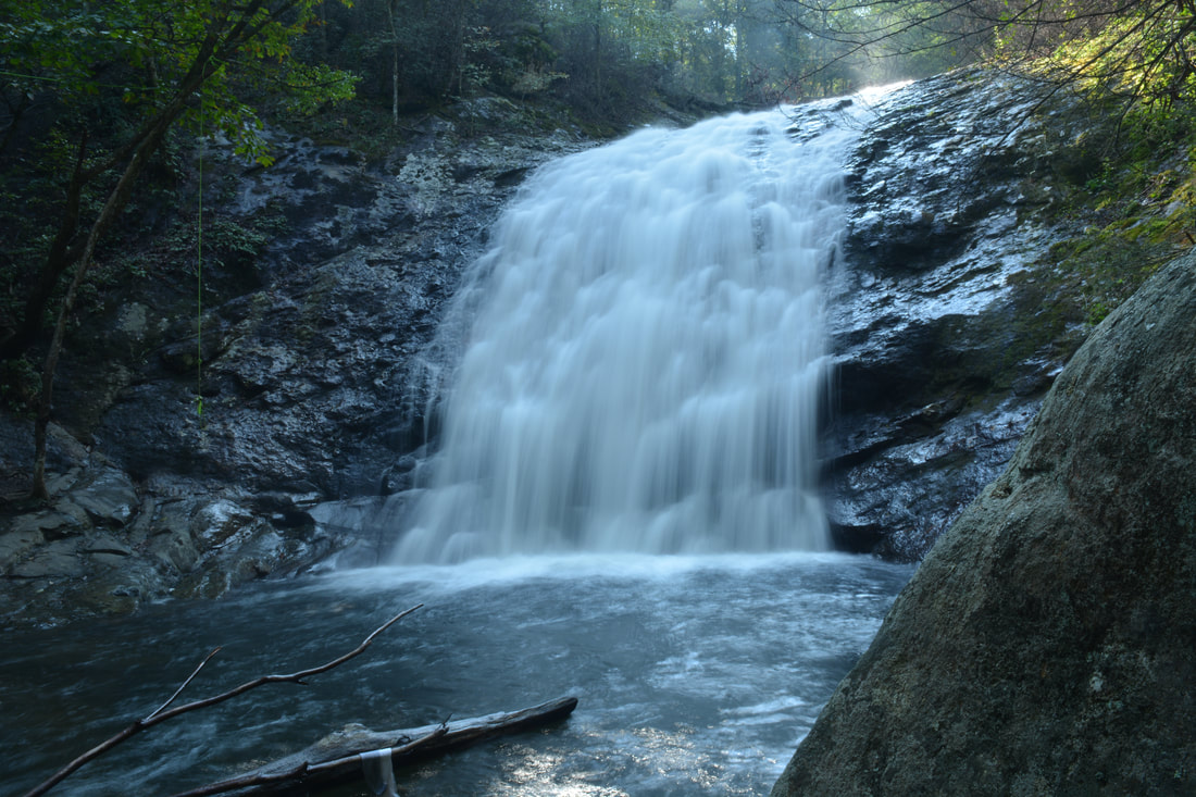
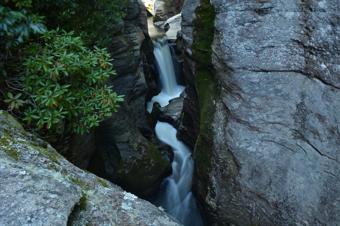
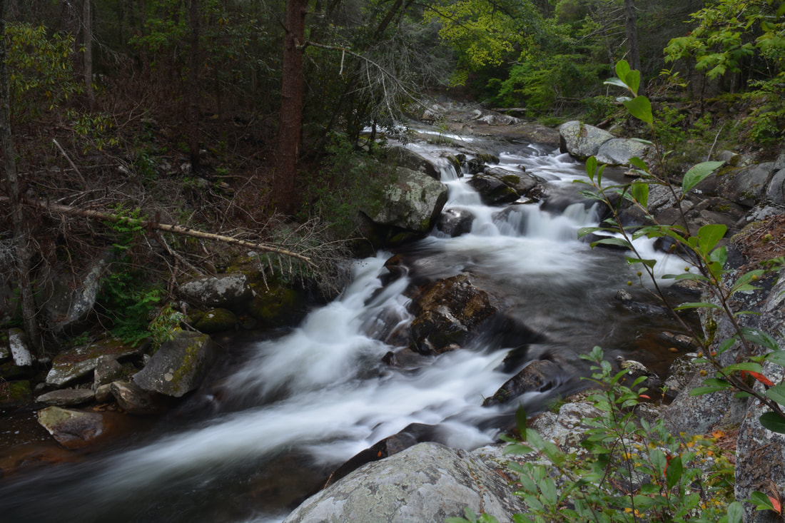
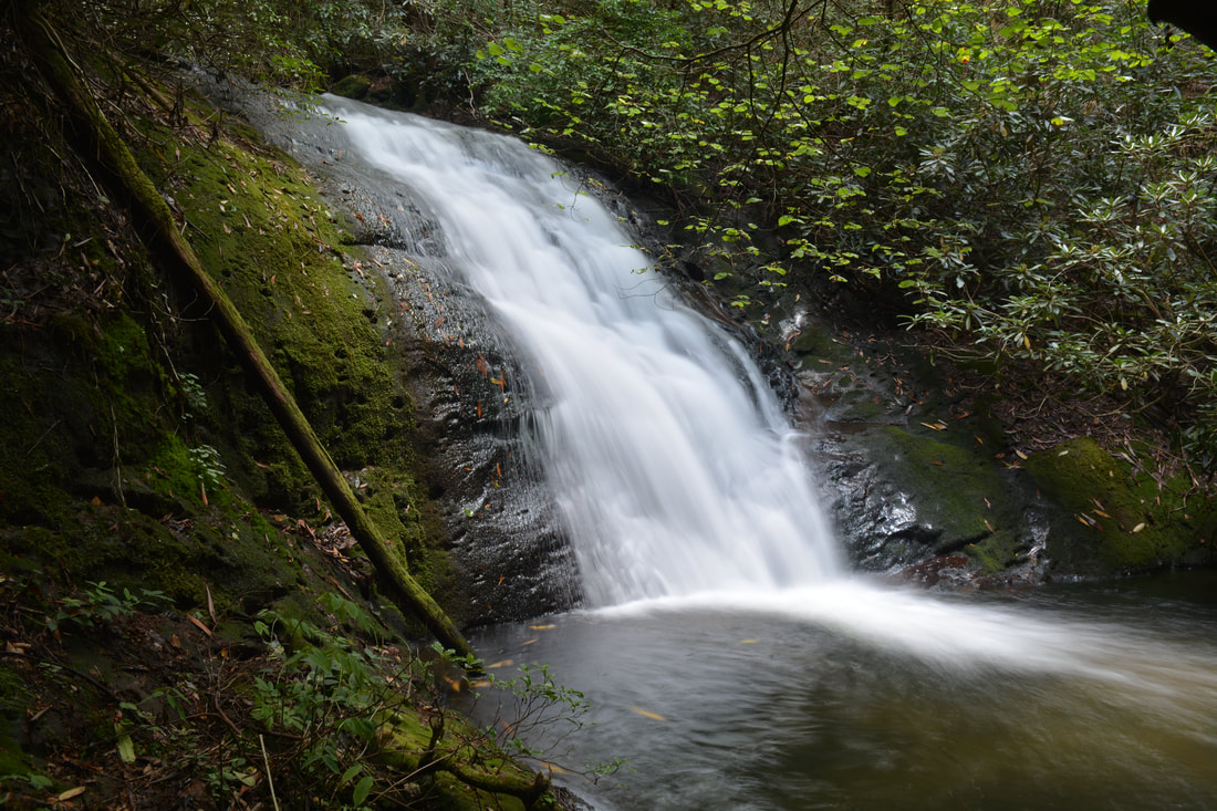
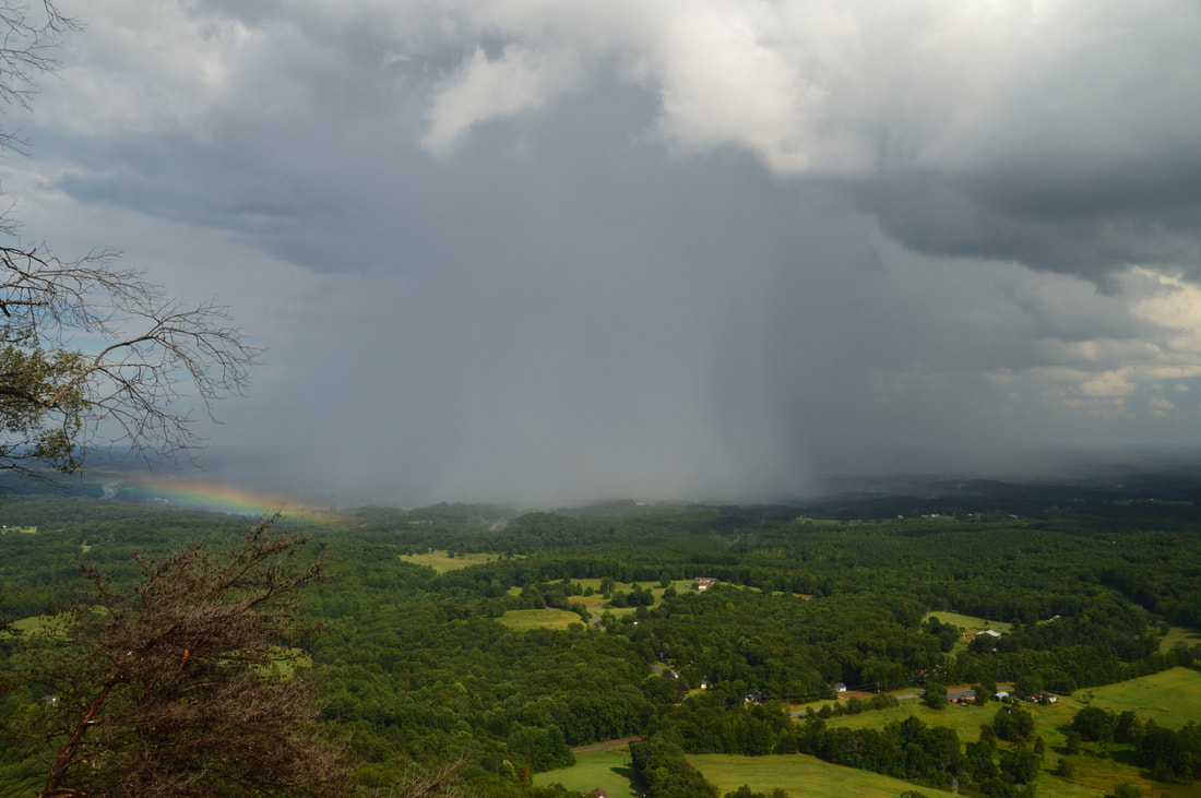
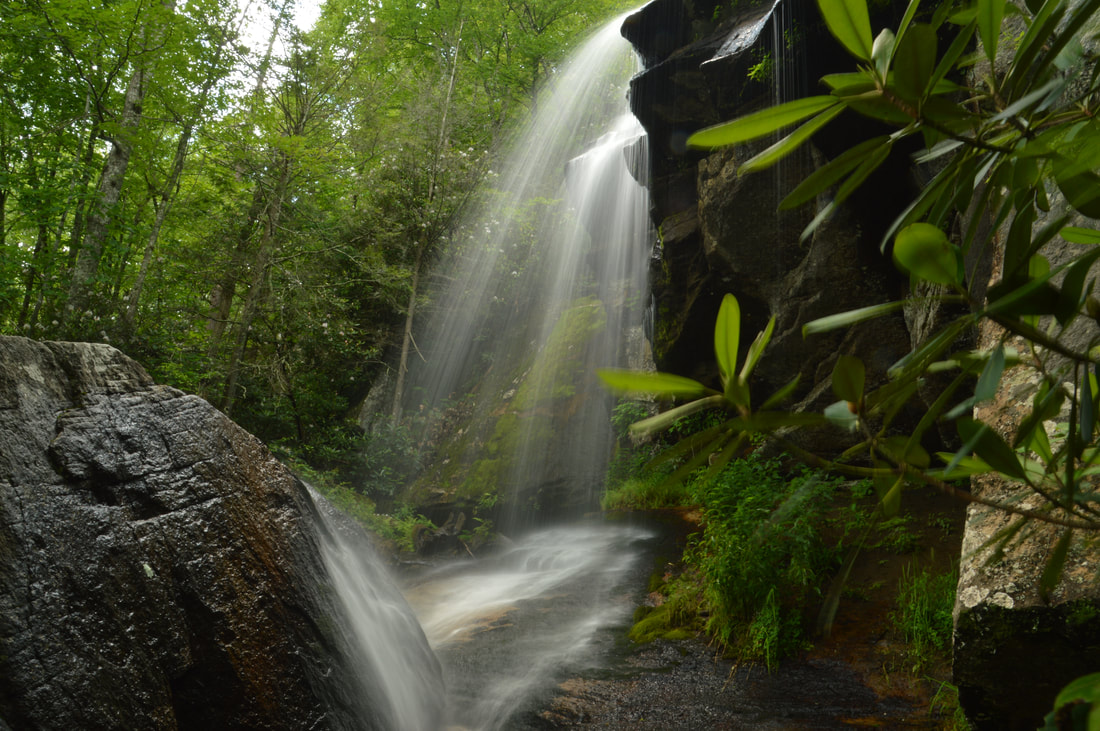
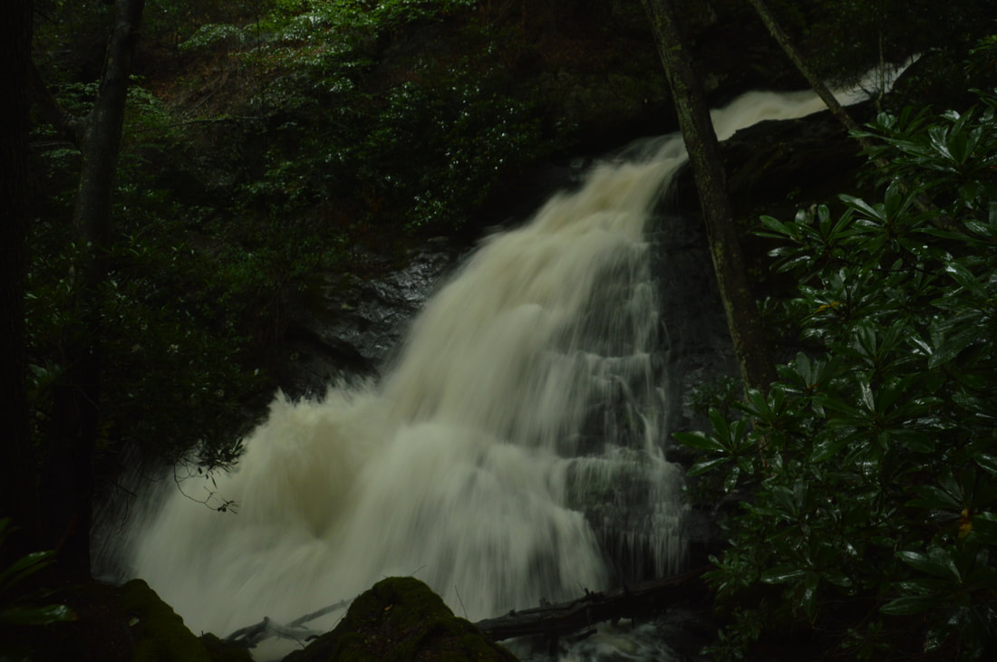
Overflow Creek in extreme northeast Rabun County is well known for its spectacular kayaking opportunities due to the creek's numerous powerful rapids and cascades. Overflow Creek has few major tributaries until it ties into the West Fork Chattooga River at Three Forks. The largest Georgia tributary is Clear Creek, a sizable stream on its own that flows from an adjacent North Carolina valley. Between the point where it enters Georgia and where it joins Overflow Creek, Clear Creek drops down two large waterfalls - the second of which is perhaps the most unique waterfall in the state. Accurately named Big Thunder Falls, this waterfall consists of a 35-foot drop hidden in an extremely narrow canyon, and while you may hear the waterfall long before you get to the canyon, you will find it very difficult to get any decent view of the falls itself. But even if you can't put your eye on Big Thunder Falls proper, the destination - an incredible very rare slot canyon in a pristine setting - is well worth the effort required to get there. The hike to Big Thunder Falls is absolutely not for beginners, as it consists of a long cross-country trek without the benefit of trails, but experienced waterfall enthusiasts and hikers seeking adventure will enjoy it immensely. This hike occurred on Friday, August 18th, 2017. My plan was to hike along a very overgrown gated forest road from the end of Billingsley Creek Road (FS 86B) to the vicinity of Clear Creek, where I would find a way to travel upstream to Big Thunder Falls. I would also make a brief detour to see Put-In Falls on Overflow Creek near the trailhead.
The northeast sector of Lake Russell Wildlife Management Area is home to the Toccoa's area best-known peak: Currahee Mountain. Even though this prominent mountain has a relatively low elevation of 1740 feet above sea level, it still is situated well above the surrounding valleys and provides commanding long-range views to the north, east, and south. A steep trail used mostly by rock climbers leads from Highway 184 to the cliffs and views atop Currahee Mountain, from where one can reach the Frady Branch Trail System with some roadwalk. Even though much of the Upper Frady Branch Trail System follows broad forest roads, it has a surprising amount of points of interest, including three historic homesites, a small quarry, an ancient cemetery, and perhaps most importantly: a 50-foot waterfall in the headwaters of Big Leatherwood Creek. Even though Big Leatherwood Falls is less than a quarter-mile from an official trail, it is a very little-known waterfall in a gorgeous pristine setting, and getting to it can be tricky due to the lack of a good path. This hike occurred on Saturday, August 12th, 2017. My plan was to hike the Currahee Mountain Trail to the summit of Currahee Mountain. There, I would follow Currahee Mountain Road to the Latham Cemetery Trailhead. I would then make a loop along the upper portions of the Frady Branch Trail System, making side trips to four historic sites and BIg Leatherwood Falls. I would retrace my earlier steps once I re-emerged on Currahee Mountain Road.
The Lake Russell Wildlife Management Area covers the southeastern extremity of Chattahoochee National Forest. This low-elevation sector of the forest is not known for pleasant hiking trails and spectacular waterfalls/overlooks to the extent that other parts of the forest are. But despite its low elevation, the Lake Russell area is home to a number of waterfalls, most of which have slipped under the radar of hikers and waterfall enthusiasts for years. One of the most spectacular waterfalls is a 50-foot sheer drop - historically referenced to as Tabor Falls - that is located well up an unnamed tributary of the Middle Fork Broad River. Even though a distinct path leads almost to the base of Tabor Falls, the waterfall is largely unknown to the outdoors community, and you're unlikely to see other people in this remote corner of Lake Russell WMA - although there may be exceptions during hunting season. This hike occurred on Saturday, August 12th, 2017. My plan was to find the easiest route from Sellers Road to a waterfall that I discovered on terrain and satellite imagery on an unnamed tributary of the Middle Fork Broad River, learning after my hike that the waterfall's historical name is Tabor Falls. I was surprised to find an unofficial trail in great condition leading almost to the base of the waterfall with only a short off-trail scramble at the end.
*UPDATE 11/12/2023: Logging operations have ended along this hike, but the trail to Tabor Falls has become more difficult to hike. For the first quarter mile from the right turn off FR 89A, the trail has been widened to a logging road and full of small downed tree trunks placed for erosion control. Don't expect a smooth path until the second right turn at the bottom of the hill.
 A 50-foot waterfall that spouts water from all sides of a jagged sheer cliff, accessible by a steep and tricky yet short path from the Blue Ridge Parkway: that's the matching description for English Falls. Located in Northwest North Carolina not far from the quaint town of Spruce Pine, English Falls possesses charm of a level that few other of the state's waterfalls seem to reach. The setting of the waterfall is magical, due to the lush greenery that peppers the cliffs and boulders at and around the falls. A small drawback of English Falls is that it is on a small unnamed stream, so the flow can be low during parts of the year. Nevertheless, visiting English Falls at the right time will yield one of the most unusual and photogenic waterfalls that you'll ever see. This hike occurred on Tuesday, July 11th, 2017, and a revisit occurred on Wednesday, June 17th, 2020. My plan was to hike out and back to English Falls via the access path from the Blue Ridge Parkway. In 2017, this hike was the tenth and final of ten hikes that I did during a seven-day trip to the mountains of northwest North Carolina.
Update 6/23/20: I have finally revisited English Falls almost three years later. The trail has changed in several ways. English Falls has seen an explosion in visitation over the last few years so the trail is now very trampled down and eroded. As a result, the hike has actually become more difficult. The slope is very slick with few footholds or handholds. Agility and experience with ropes are a must to complete this scramble safely. The trip report has been revised with the most recent directions plus information about Upper English Falls. UPDATE JULY 2023: ROADSIDE PARKING IS NOW PROHIBITED ALL ALONG THE BLUE RIDGE PARKWAY NEAR ENGLISH FALLS. ILLEGALLY-PARKED VEHICLES WILL BE TICKETED. The nearest authorized parking area is over a mile away. The status of the scramble path itself is unclear. Most of the path lies on National Park Service land. It is widely rumored to be closed but no official word has been obtained from the NPS. 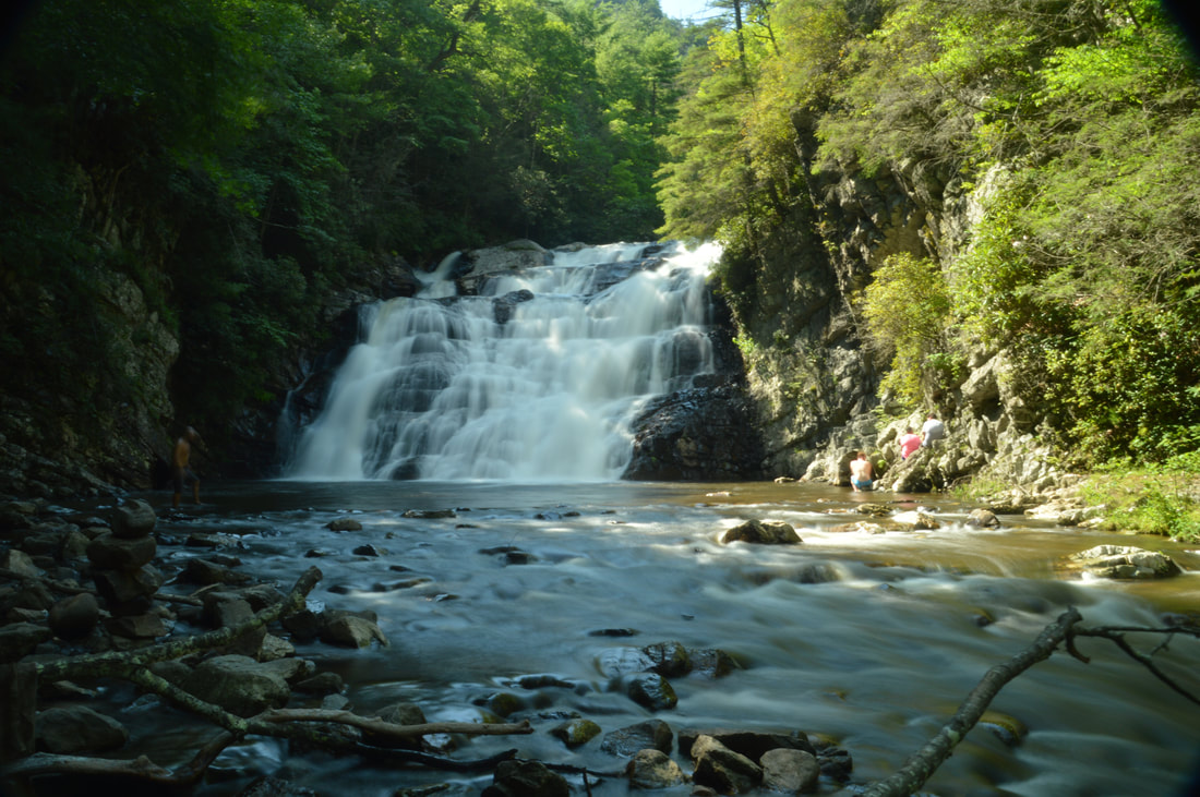
The 55-foot Laurel Falls is one of Northeast Tennessee's most breathtaking waterfalls. Located just outside of the community of Hampton and off the Appalachian Trail in Pond Mountain Wilderness, access to Laurel Falls is fairly easy, making it a destination that can often be crowded, but the falls and the whole hike is still worthwhile - for there is a lot more to see along this stretch of the AT. Above Laurel Falls, an unofficial side trail makes a steep scramble to the pointy summit of Potato Top, where there are several excellent views of the Laurel Fork Gorge and surrounding wilderness. In addition, the Appalachian Trail between US 321 and Dennis Cove Road passes a lot of pretty creekside scenery and several spectacular cliffs that rise along Laurel Fork Creek. This hike occurred on Sunday, July 9th, 2017. My plan was to hike out and back along the Hampton Blueline Trail and then Appalachian Trail from the trailhead off US 321 near Hampton to the Dennis Cove Trailhead. Along the way, I would take the side trails to Potato Top and Laurel Falls, and on my way back, I would take the high-water bypass route past Laurel Fork Shelter above Laurel Falls for a bit of variation. This hike was the eighth of ten hikes that I did during a seven-day trip to the mountains of northwest North Carolina.
The Linville Gorge Wilderness of Pisgah National Forest, North Carolina's third largest wilderness area, encompasses an area that is one of the most rugged areas in the Southeast: Linville Gorge. Flowing along the bottom of the gorge is the boulder-strewn Linville River, located as much as over 1500 feet below the gorge's rims at its deepest spots. The Linville Gorge Trail runs through nearly the entire length of the gorge, passing countless obstacles as it follows the steep banks of the Linville River for miles. An array of trails and roads runs along the rims of the gorge, and a number of extremely steep paths provide access to the gorge floor, allowing one to hike loops of varying length encompassing both the gorge floor and rim. One of those loops is the Rock Jock Loop: a spectacular yet grueling hike that passes at least six particularly breathtaking vistas and many other smaller views as well as numerous cataracts on the Linville River and one tall waterfall on its tributary. While it is possible to hike the Rock Jock Loop in one day like I did, it will be very tiring, and in order to get the most enjoyable and relaxing experience, turning the Rock Jock Loop into a weekend backpacking trip could be a good idea. This hike occurred on Saturday, July 8th, 2017. My plan was to hike the Rock Jock Loop/Linville Gorge Loop counter-clockwise from the Conley Cove Trailhead. This hike was the seventh of ten hikes that I did during a seven-day trip to the mountains of northwest North Carolina.
Linville Falls is one of the most photographed waterfalls in North Carolina. Located on the Linville River at the very head of Linville Gorge, the falls cascades over a hundred feet via multiple tiers, crashing into a huge plunge pool lined by tall cliffs at the end of the final 45-foot tier of the falls. A network of popular trails, stemming from the Linville Falls Visitor Center, weaves around the falls and leads to five different viewpoints of it (including the base itself). In addition, a bonus waterfall known as Duggers Creek Falls can be seen from one of the trails. This hike occurred on Friday, July 7th, 2017. My plan was to hike out and back to each of the five viewpoints of Linville Falls as well as Duggers Creek Falls from Linville Falls Visitor Center. This hike was the fifth of ten hikes that I did during a seven-day trip to the mountains of northwest North Carolina.
The Wilson Creek watershed in the Grandfather Ranger District of Pisgah National Forest is well-known for its numerous hiking trails and backpacking opportunities. One of the largest tributaries of Wilson Creek is Harper Creek. Harper Creek and its tributaries are home to several spectacular waterfalls in the shadow of Grandfather Mountain. Particularly impressive is South Harper Creek Falls: a massive 120-foot double sliding waterfall that can be viewed from three distinct locations: the base, the midpoint, and the cliffs on the other side of Harper Creek. If you hike the Harper Creek Loop, you'll also pass triple-tier Harper Creek Falls - that isn't too shabby either - and have the option to take a lengthy side trail to Bard Falls on North Harper Creek. However, it is best to be prepared for overgrown trails and over a dozen wet crossings of Harper Creek if you do hike the full loop. This hike occurred on Thursday, July 6th, 2017. My plan was to hike the Harper Creek Loop counter-clockwise from Brown Mountain Beach Road, following the Harper Creek Trail and then the Raider Camp Trail. Along the way, I would take a side trip to Bard Falls along the North Harper Creek Trail, and I would also take short side trails to Harper Creek Falls and three different viewpoints for South Harper Creek Falls. This hike was the fourth of ten hikes that I did during a seven-day trip to the mountains of northwest North Carolina.
The Elk River is best known for its spectacular upper waterfall, Elk River Falls. But as the Elk River enters Tennessee, it encounters a twisting passage with a series of waterfalls collectively known as Twisting Falls that is even more jaw-dropping. The 35-foot lowermost drop of Twisting Falls, locally known as Compression Falls, creates one of the area's most impressive sights as it crashes with a deafening roar into a deep pool flanked by tall cliffs. The trail to the base of the falls is no joke though - the unofficial path descends over 400 feet to the Elk River in just a quarter-mile! The destination waterfall is well worth it, but be prepared to huff and puff on the way back up. This hike occurred on Wednesday, July 5th, 2017. My plan was to hike out and back to the base of the lowermost drop of Twisting Falls (aka Compression Falls). This hike was the second of ten hikes that I did during a seven-day trip to the mountains of northwest North Carolina.
If you're looking for the perfect combination of beauty and ease of access to a waterfall in North Carolina, Elk River Falls has to be at the top of your list. A well-used relaxing trail leads along the banks of the mighty Elk River to the base of Elk River Falls, a tight sheer 50-foot drop into a huge plunge pool that is known for its swimming opportunities. Most folks who hike to Elk River Falls don't know that another excellent waterfall can be reached fairly easily from the same trailhead. 100-foot Jones Falls is on a small tributary of the Elk River and during the wetter months is a sight no less impressive than Elk River Falls. A signed spur trail from the Appalachian Trail facilitates access to this gorgeous spot. Hikers will be able to see both waterfalls with a hike of fewer than four miles. This hike occurred on Wednesday, July 5th, 2017. My plan was to hike out and back to Elk River Falls and then to follow a forest road and unofficial connector path to the Appalachian Trail, which I would use to reach Jones Falls. I would return the same way. This hike was the first of ten hikes that I did during a seven-day trip to the mountains of northwest North Carolina.
Canada Creek is one of my favorite mountain streams in North Georgia, due to a perfect combination of beauty, remoteness, and ease of access at each of the creek's four scenic waterfalls. A network of unofficial trails used by fishers and hunters weave around Canada Creek and provide fairly easy access to each of its waterfalls. The hikes to each particular waterfall aren't too long, but seeing all of the waterfalls together will take a good part of the day. A topographic map and compass are recommended for hikers who venture into the Canada Creek area, because many disorienting trail junctions are found throughout the trail system, and some of the paths are faint. This hike occurred on Saturday, July 1st, 2017. My original plan was to hike out and back to Yukon Falls on Canada Creek from the Upper Canada Creek Trailhead. After seeing the roaring state of the Yukon Falls though, I decided to use a connector to access Alberta Falls on Canada Creek and then loop back using a couple of roads.
|
About MeMark Oleg Ozboyd Dear readers: I have invested a tremendous amount of time and effort in this website and the Georgia Waterfalls Database the past five years. All of the work that has gone in keeping these websites updated with my latest trip reports has almost been like a full-time job. This has not allowed me to pick up a paid job to save up money for college, and therefore, I I've had to take out loans. If you find the information on this website interesting, helpful, or time-saving, you can say "thanks" and help me out by clicking the button above and making a contribution. I will be very grateful for any amount of support you give, as all of it will apply toward my college tuition. Thank you!

Coming in 2022-2023?
Other Hiking WebsitesMiles HikedYear 1: 540.0 Miles
Year 2: 552.3 Miles Year 3: 518.4 Miles Year 4: 482.4 Miles Year 5: 259.9 Miles Archives
March 2021
Categories
All
|
 RSS Feed