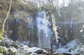
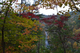
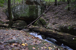
The Citico Creek Wilderness is one of the wildest areas in southeast Tennessee. A network of trails provides foot access into the pristine watershed. Falls Branch Falls, located at the head of a remote valley on a tributary of South Fork Citico Creek, is the tallest waterfall in the Citico Creek Wilderness. From the Cherohala Skyway, take a short trail into the Falls Branch Scenic Area and through an old-growth forest to Falls Branch and the 80-foot falls. This hike occurred on Saturday, February 27, 2016. My plan was to hike the Falls Branch Falls Trail out and back from the Cherohala Skyway to Falls Branch Falls. After this short hike, I would drive to nearby Beech Gap on the Cherohala Skyway and complete a longer hike, detailed in a separate trail report.
0 Comments
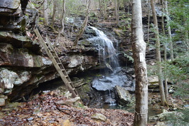 If there ever was a hike that you must absolutely not miss, no matter where you have hiked or are planning to hike, then this is it. As my personal favorite hike on the Cumberland Trail (at least to this date), this is one segment of the famous long-distance trail that has just about everything that you can find on the Cumberland Plateau, from tall bluff lines that stretch on for miles, to spectacular vistas of one of the area's most picturesque gorges, Chickamauga Gulch, to remote waterfalls set in some of the best settings I've yet to see in this area. This is truly one spectacular hike by all means. This hike occurred on Saturday, January 16th, 2016. My plan was to hike the Cumberland Trail from the trailhead on Montlake Road to Panther Branch Overlook. However, due to time-consuming photography of the countless points of interest on this hike, as well as to the extremely rugged and slow nature of the latter part of the hike, I was only able to reach Stevenson Branch Falls. That was okay with me, however, as I have hiked the excellent section of the Cumberland Trail north of Stevenson Branch Falls, and the section to the south, that I hiked on this day, proved to be even more spectacular.
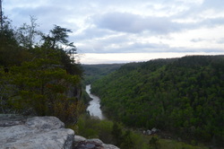
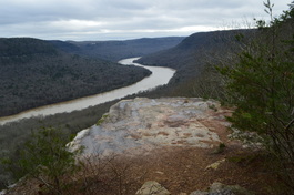 The Tennessee River is Tennessee's grand river. Near the city of Chattanooga, the river carves a passage through a deep gorge before becoming Nickajack Lake. On this hike atop a finger of the Cumberland Plateau that juts out into the Tennessee River Gorge, you will see several vistas of the river, a bizarre geological formation called the Natural Bridge, and a number of wet-weather waterfalls - they really are invisible, unless you happen to hike the trail in the middle or after a notable flooding event. Expect quite a workout curving throughout countless hollows before arriving at Ransom Hollow Overlook, one of the best vistas on the southern Cumberland Plateau. This hike occurred on Saturday, December 26th, 2015. My plan was to hike the Pot Point Loop clockwise from the Snoopers Rock Trailhead.
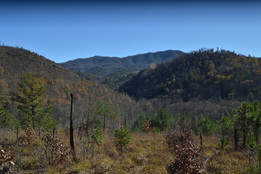 The Warriors Passage Trail is one of two National Recreational Trails in Cherokee National Forest. This seldom-traveled pathway traverses a couple of low-elevation stream valleys before climbing up to Waucheesi Mountain, a small bald summit with views across the Tellico Ranger District. This hike occurred on Saturday, November 14th, 2015. My plan was to hike the entire Warriors Passage Trail out and back from Lyons Creek Trailhead to Waucheesi Mountain.
 Two large rivers are the highlights of southern Cherokee National Forest's Ocoee/Hiwassee Ranger District: the Ocoee River and the Hiwassee River. Both rivers run through gorgeous canyons and are full of whitewater rapids. The John Muir Trail (and partially in conjunction with the Benton Mackaye Trail) runs along the northern shores of the Hiwassee River for a distance of nearly 20 miles, presenting opportunities to see the river's rapids and rock formations up close. This hike occurred on October 24th, 2015. My plan was to hike the John Muir Trail/Benton Mackaye Trail from the Big Bend Recreation Area to the Coker Creek footbridge at Duckett Ridge Trailhead. I would return almost the same way, although on the return trip, I would attempt to follow the old route of the John Muir Trail past Apalachia Powerhouse.
 The Lookout Mountain Battlefield is a large tract of conserved land that covers the better portion of Lookout Mountain's slopes. The area that this tract covers is the site of the Battle of Lookout Mountain (a battle that was a part of the US Civil War's Chattanooga Campaign). The area is home to an assortment of interesting sights, most notably several rather large springs, as well as many important historic sights and even some good vistas. The mountain is crisscrossed by trails, and there are many ways to create long day hikes on Lookout Mountain. This hike occurred on October 10th, 2015. My plan was to hike to a number of features on the west side of Lookout Mountain: Skyuka Spring, Sunset Rock, and Gum Spring, but due to some confusing intersections, the total mileage of the hike had to be increased to the point that only Skyuka Spring was seen in the daylight. My plan was to start on the Kiddie Trail. I would then take the Skyuka Trail to Skyuka Spring, and follow the John Smartt Trail and later the Jackson Gap Trail to the Bluff Trail. The Bluff Trail would be followed to Sunset Rock, and then using the Gum Spring Trail and Lower Gum Spring Trail, I would return to the trailhead. As you'll see below, this plan didn't quite work out.
Franklin-Marion State Forest is a large tract of conserved land on the southern Cumberland Plateau, totaling to nearly 8000 acres. An assortment of hiking trails circles the forest, leading to various vistas of the surrounding coves and several small waterfalls. Unfortunately, the trail system has been let down in recent years and now receives mainly horse traffic. The horse traffic makes this hike rather unattractive, but still, it has its rewards. This hike occurred on Saturday, September 19th, 2015. My plan was to hike the Cave Spring Trail to the West Rim Trail and then follow the West Rim Trail to its northern terminus. From there, I would do the North Rim Trail out and back. Finally, I would do the Sweden Cove Trail to TN State Route 156 and return to the trailhead via TN 156.
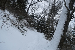
Deep in the mountains of northwestern North Carolina and northeastern Tennessee lie the Highlands of Roan. This widely-known name represents one of the most beautiful spots in the Southeast, and perhaps the entire Appalachian Mountains. This series of mountain balds lies on the route of the Appalachian Trail, and quite a scenic of a hike it is. Whether you're coming here for the spring wildflowers, the autumn foliage show, or after a winter snowstorm, you're not likely to be disappointed (except it may be a little too cold in winter). Although only the most seasoned hiker will be able to do this physically difficult and tiring trek in a single day, there are several variations that can split this hike into several, and then, there's always the backpacking option. This hike occurred on Saturday, June 13th, 2015. My plan was to hike the Appalachian Trail from Carvers Gap over Round Bald, Jane Bald, and Little Hump Mountain, finishing at Big Hump Mountain. I would return the same way. I would also take the spur trails to Grassy Ridge Bald and Overmountain Shelter.
The Big South Fork of the Cumberland River is one of the biggest to bisect the Cumberland Plateau. It flows through a rugged gorge in extreme northern Tennessee and then into Kentucky, before flowing into the Cumberland River near Somerset. This hike is one of the best for your first visit to the area, as it encompasses the shear beauty of the gorge and surroundings, culminating in one of the most beautiful overlooks I have ever encountered anywhere - Angel Falls Overlook - making this one of the best hikes in Tennessee. This hike occurred on Thursday, April 16, 2015. My plan was to start my hike at the East Rim Trailhead. I'd first see East Rim Overlook and do the short hike to Sunset Overlook. And then, I would do the Leatherwood Loop and follow the John Muir Trail to Angel Falls Overlook and back.
Cumberland Trail: Shut-in Gap Road (East Trailhead) to White Pine Cascades, Spring City, Tennessee4/21/2015 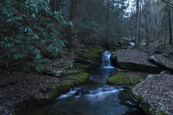
The Piney River is one of the larger waterways that the Cumberland Trail intersects or follows. Amidst its large watershed, the Cumberland Trail visits five cascades and waterfalls, and also provides excellent water views. In addition, visit Twin Rocks Overlook and make a fun rock scramble to reach the views at the top. This hike occurred on Saturday, March 28th, 2015. My plan was to hike the Cumberland Trail from the Piney River/Shut-in Gap Road Trailhead to at least White Pine Cascades with a side trip to Twin Rocks Overlook. Time permitting, I would continue all the way to the western Shut-In Gap Road Trailhead.
Located to the north of the Cherohala Skyway in southeastern Tennessee, the Citico Creek watershed offers rugged, wilderness hiking opportunities for true hiking enthusiasts. On this hike, you'll have a chance to see three waterfalls in the beautiful setting of the headwaters of North Fork Citico Creek. In addition, you have an option of continuing past the waterfalls and attempting to return down Brushy Mountain Trail - maybe your luck will be better than mine. This hike occurred on Saturday, March 21st, 2015. My plan was to hike the South Fork Trail to the place where North Fork Trail starts, and then to follow the North Fork Trail to Cold Springs Gap Trail or perhaps to Cherry Log Gap. I would either take the Benton Mackaye Trail or Cold Springs Gap Trail to Brushy Mountain Trail. Then, I would start down the Brushy Mountain Trail and hopefully make it down back to South Fork Trail without any major problems. My plan didn't materialize, and I ended up backtracking from about 1 mile down the Brushy Mountain Trail.
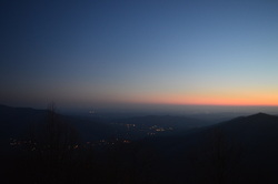
Mount LeConte is the most famous mountain in Great Smoky Mountains National Park. Being in the list of the top 25 highest peaks in the eastern US, it is also the tallest peak in the eastern US measured directly from its base near Gatlinburg. The mountain is home to a hikers lodge, accessed only by foot. The lodge provides amenities in all times of the year except winter. Due to the popularity of LeConte, five trails lead to the summit. If you have followed this blog for a little bit, you might have seen that I have already hiked to Mount LeConte via Alum Cave Trail. Unfortunately, I came to a fogged in overlook. This was my second attempt of seeing the views on Mount LeConte, with an even more challenging hike. And this time, due to my hiking partner not being in shape, the 4000-foot climb took considerably more time than expected. I arrived at the summit in the dark, but at least I was able to capture a good night picture of Pigeon Forge - even that wasn't possible last time. One day I'll set out on my third attempt to hike up to LeConte to see the views, and I know I won't fail that time. This hike occurred on February 28, 2015. My plan was to hike up to Mount LeConte via Rainbow Falls Trail, see the views from Cliff Tops, Myrtle Point, and Rocky Spur, and then return by Bullhead Trail.
 The Tellico River watershed is home to some of the most pristine and beautiful streams in Tennessee. Two wilderness areas, Bald River Gorge Wlderness and Citico Creek Wilderness, protect some of its major tributaries, and many hiking trails pass through the region. One of the more notable trails is the Benton Mackaye Trail, a nearly 300-mile trail that start in northern Georgia and ends in the Smoky Mountains. The section of the Benton Mackaye Trail described here is long and hard, but the view at the end is stunning. However, if you go, don't be like me and end up hiking nearly 30 miles instead of no more than 17 from one mistake. This hike occurred on January 31st, 2015. My plan was to hike the Benton Mackaye Trail from Tellico Trout Hatchery at the Tellico River to Whiggs Meadow. Much of this hike would also be along Sycamore Creek Trail. From Whiggs Meadow, I opted for a shorter return route, along Whiggs Ridge Trail... except I didn't find the trail. I will explain more on this later.
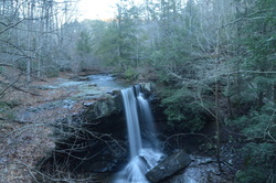
 The Cumberland Mountains is the Cumberland Plateau with a twist - the same canyons but higher elevations and better views. Frozen Head State Park has some of the best the Cumberland Mountains have to offer: two waterfalls and a fire tower with panoramic views. This hike occurred on January 24th, 2015. My plan was to hike the Panther Branch Trail to North Old Mac Trail, and take the North Old Mac Trail to Frozen Had Lookout Tower. Along the way, I would stop at DeBord Falls and do the spur trail to Emory Gap Falls. From the Lookout Tower, I would return by Lookout Tower Trail back to the main park road, and then follow it back to the trailhead.
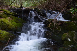
 South Cumberland State Park is one of the most beautiful and diverse areas in Tennessee. The park is not your regular state park. Spread over several counties and in many different land tracts, the state park protects some of the most scenic streams and waterfalls on the Cumberland Plateau. The Savage Gulf State Natural Area, one of the largest sections of South Cumberland State Park, houses nearly a dozen of these waterfalls, and on this hike, you'll get a chance to see five. In addition to the waterfalls, panoramic views abound at the Stone Door Overlook - get to see into the heart of Savage Gulf and hike through a narrow crack in the plateau rim known as the Stone Door. This hike occurred on Saturday, January 17, 2015. My plan was to start my hike at the Greeter Falls Trailhead, and hike the Greeter Falls Loop past Greeter Falls, Upper Greeter Falls, and Boardtree Falls, before taking the Greeter Trail. Following the Greeter Trail, I would take the Big Creek Rim Trail to the panoramic views at the Stone Door. From there, I would take the Stone Door Trail to Laurel Falls and return the same way to the Stone Door. From here, I would take the Big Creek Gulf Trail with a side trip to Ranger Creek Falls, before returning to the Greeter Trail junction and retrace my steps to the trailhead.
|
About MeMark Oleg Ozboyd Dear readers: I have invested a tremendous amount of time and effort in this website and the Georgia Waterfalls Database the past five years. All of the work that has gone in keeping these websites updated with my latest trip reports has almost been like a full-time job. This has not allowed me to pick up a paid job to save up money for college, and therefore, I I've had to take out loans. If you find the information on this website interesting, helpful, or time-saving, you can say "thanks" and help me out by clicking the button above and making a contribution. I will be very grateful for any amount of support you give, as all of it will apply toward my college tuition. Thank you!

Coming in 2022-2023?
Other Hiking WebsitesMiles HikedYear 1: 540.0 Miles
Year 2: 552.3 Miles Year 3: 518.4 Miles Year 4: 482.4 Miles Year 5: 259.9 Miles Archives
March 2021
Categories
All
|
 RSS Feed