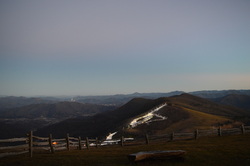
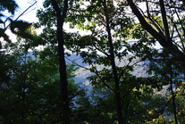
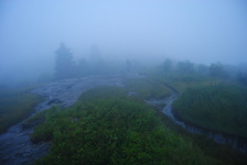
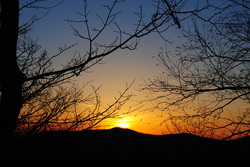
 The Cataloochee area of the Great Smoky Mountains National Park is an overlooked and very scenic region. Cataloochee Divide marks the eastern boundary of GSMNP in this area, separating Cataloochee Valley and Maggie Valley. Cataloochee Divide Trail might be one of the most spectacular trail in the entire park, if hiked during winter. Views sprout in all directions. However, the section described here is a good hike even during summer, with amazing views from Hemphill Bald and Purchase Knob. Along the way back, take a minute to stop at and explore the Ferguson Cabin located just below Purchase Knob. This hike occurred on Thursday, December 25th, 2014. My plan was to park at the gate on Purchase Road, and then hike up Purchase Road to Purchase Knob. From there, I would pick up the Cataloochee Divide Trail and follow it past the The SWAG to Hemphill Bald. I would retrace my steps back, but instead of climbing back up Purchase Knob, I would shortcut it using the Ferguson Cabin Trail.
2 Comments
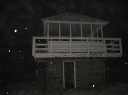 The Cowee Mountains is the highest mountain range in the Highlands-Cashiers area, with many mountains approaching 5000 feet. This hike leads to the highest point in the Cowee Mountains as well as the highest point in the entire Highlands-Cashiers area, Yellow Mountain. Yellow Mountain rises to 5127 feet, and has a historic, renovated fire lookout. You'll also pass over several other mountains with great winter views and some viewpoints as well. Chances are you will be tired by the time you make it back to the trailhead at Cole Gap, and although the fact that the route back is almost as hard as the way in is pretty major, the rewards will sill be worth it, especially on a clear day. This hike occurred on Thursday, November 27th, 2014. My plan was to hike the Yellow Mountain Trail from Cole Gap to Yellow Mountain, and then return the same way.
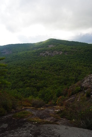
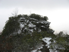 The Plott Balsam Mountains of Western North Carolina, sometimes considered part of the Great Smoky Mountains, is one of the most scenic areas along the southern Blue Ridge Parkway. A long history exists behind the land covering the western Plotts. Until 1991, the area now called Pinnacle Park was a watershed providing the town of Sylva's residents' water. Then, Sylva's residents were in need of a better water supply, and the watershed was transformed into a public park maintained by The Pinnacle Park Foundation. The main reason of this was to allow public access to the Pinnacle, a jagged rock outcrop on the very western end of the Plott Balsams, making for a sharp ending to the long ridgeline. Nearby, the exceptionally steep and rugged peak of Blackrock was previously on private land, until just a handful of years ago when the Blackrock Ridge Tract was purchased. Since then, these two features are fully connected to trails extending from the Blue Ridge Parkway. This hike occurred on Saturday, November 1st, 2014. My plan was to hike the West Fork Trail from the Pinnacle Park trailhead to the summit of Blackrock, and if time would permit, to Waterrock Knob. Along the way, I would take the side trail to The Pinnacle.
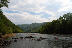
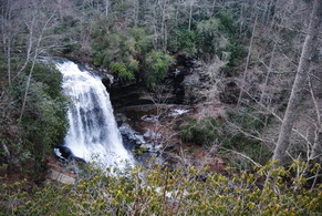
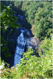 I have hiked a bit on the Foothills Trail, but in general I have underestimated it. This primer on the Foothills Trail in extreme upstate South Carolina is about as good as it can get while hiking - in fact, this is one of my favorite hikes not only this year, but in the past few years. The Whitewater River starts in the mountains near Cashiers, and grows on its way to Lake Jocassee. There are six waterfalls on the Whitewater River, but two waterfalls are the biggest ones, and more importantly, will take your breath. First, Upper Whitewater Falls is a gigantic double-tiered waterfall, claimed to be the highest waterfall east of the Mississippi River. Following this, the Whitewater River plunges with whitewater through the Whitewater River Gorge, exiting the gorge with another dramatic drop at Lower Whitewater Falls, into Lake Jocassee. This hike occurred on Saturday, October 11th, 2014. My plan was to take the Bad Creek Access Trail to the Foothills Trail, and first take the Foothills Trail east to the Lower Whitewater Falls Trail, and follow it to the Lower Whitewater Falls Overlook. Following this, I would backtrack to the Bad Creek Access Trail, and take the Foothills Trail northwest to Upper Whitewater Falls. After this, I would return the same way to the trailhead.
 The Tusquitee Mountains of Southwest North Carolina are a beautiful mountain sub-range located near Hayesville. The highest mountain, Tusquitee Bald, tops out higher than 5000 feet. In a deep valley shaded by the mountains' crests flows Fires Creek. This clear, mountain stream houses a population of trout, rarely found in some of the mountains. The Fires Creek Rim Trail is the main trail that goes around the Tusquitee Mountains. However, there are also access trails, and the Chunky Gal Trail, which comes from the southeast. This hike occurred on October 4th, 2014. My original plan was to hike to Tusquitee Bald, but some roads were closed (possibly for hunting season), so I had to change my plan to starting at the Bristol Horse Camp, and doing the Bristol Trail to Fires Creek Rim Trail. Then, I would take the Fires Creek Rim Trail to the right (south-southwest) and follow it to Fires Creek Picnic Area. I wanted to return by the Cover Trail, but after quickly realizing that it has 18 fords, certainly not inviting in 40-degree weather, I bailed out and decided to return by the Fires Creek Road.
 Highlands and Cashiers are two small, wealthy towns in the mountains of Southwest North Carolina surrounded by mountains with great views and great hiking trails. The Panthertown Valley Recreation Area is one of the best hiking destinations in the area, with several mountains with great views, and at least a dozen accessible waterfalls. Panthertown Valley, nicknamed "The Yosemite of the East". Mountains like Little Green Mountain alone are worth doing this hike - traversing it's open rocky faces with incredible views is quite a feeling. This hike occurred on Saturday, September 13th, 2014. My plan was as follows (and it's a long one): From the Packs Gap Trailhead, take the Blackrock Spur Trail to Blackrock Trail. From there, I'd follow the Blackrock Trail to Overlook Trail. I would take the Overlook Trail to Blackrock Mountain Overlook and to the Powerline Trail. I would turn right on the Powerline Trail and go all the way to Panthertown Valley Trail. Along the way, I would do the short out-and-back to Wardens Falls. Then, I would turn left on Panthertown Valley Trail, followed by turning right onto Little Green Trail. After visiting Schoolhouse Falls, I would summit Little Green Mountain and on the other side of the mountain, turn left on Mac's Gap Trail. Then, I would turn right onto Big Green Trail and follow it to Great Wall Trail. I would turn left onto the Great Wall Trail and follow it to Granny Burrel Falls Trail. After doing the short out-and-back to Granny Burrell Falls, I would continue on the Great Wall Trail to Deep Gap Trail. I would turn left onto Deep Gap Trail, and immediately right onto Wilderness Falls Trail. Finally, I would finish by turning left onto the Panthertown Valley Trail and ascend to Packs Gap.
 Hot Springs is a small, tourist town, with a lot of history and legends behind it. It used to be bigger, but following two consecutive hotel fires, the current resort there is much smaller, so there's not as many people as used to come. For hikers like us, though, the main point of Hot Spring is that the AT passes right through the town, and follows the Main Street sidewalk for a mile. On this hike, there will be multiple features of interest - Lovers Leap Overlook, Mill Ridge, and most importantly, Rich Mountain Fire Tower. This hike occurred on August 30, 2014. Start off by following a section of the Appalachian Trail from Silvermine Trailhead to Rich Mountain. You'll return by a much shorter, albeit steeper way down the Roundtop Ridge Trail back into Hot Springs.
 The Fishawk Mountains west of Highlands are a small ridgeline and part of the Bartram Trail's route. In this area, the mountains house massive rock faces and fantastic panoramas of the Little Tennessee River Valley and Nantahala Mountains. This is easily one of the best hikes in the Highlands area. This hike occurred on Saturday, August 16th, 2014. My plan was to start my hike at the Jones Gap Trailhead and hike on the Bartram Trail to Wolf Rock. I would return the same way. Also, I would check out Jones Knob and Whiterock Mountain along the way. I would skip the Fishawk Mountain spur, though.
 The North Carolina High Country is a beautiful area. It is part of the Pisgah National Forest, and part of it is also classified as the Shining Rock Wilderness. The NC High Country is where the mountain tops are bald, black balsam trees/forests are abundant, and steep, rushing streams descend into the valleys below to form some of the bigger rivers in the area. The drainages on the south side eventually end up in the Mills River, whereas the drainages on the north side end up in the Pigeon River. Yellowstone Prong is one of the major tributaries of the Mills River on the south side. Just below the bald summit of Black Balsam Mountain, Yellowstone Prong begins its journey southward towards the Mills River, and on the way, it passes through an outlier: a somewhat swampy, lush mountain meadow known as Graveyard Fields. This hike occurred on Saturday, July 19th, 2014, My original plan was to start at the Graveyard Fields Overlook on the Blue Ridge Parkway, hike down into Graveyard Fields via the Graveyard Fields Loop on the west side, and then take the spur trail to Upper Falls out and back. From there, I would take the Graveyard Ridge Connector to the Graveyard Ridge Trail, and the Graveyard Ridge Trail west to the Mountains-to-Sea Trail. Next, I would take the M-t-S to Black Balsam Road, and then the Art Loeb Trail over the bald summits of Black Balsam Mountain and Tennent Mountain to Ivestor Gap. From here, I would return by taking the Graveyard Ridge Trail southward back to the M-t-S. However, to add variety, I would turn left onto the M-t-S at the junction, and then return via the M-t-S Connector to Graveyard Fields Loop. Finally, I would return via the paved path out of Graveyard Fields to the parking area at the overlook. Sounds good enough, eh? Well, what actually happened was a little different. I got to a false gap what I thought was Ivestor Gap, and when I couldn't find Graveyard Ridge Trail, I took the old logging road that went to the left and connected with Ivestor Gap Trail. I followed Ivestor Gap Trail to Black Balsam Road, and finished the hike with 3 miles of roadwalk. This description will follow the actual route of my hike.
Appalachian Trail: Nantahala Outdoor Center (NOC) to Wesser Bald, Bryson City, North Carolina7/14/2014 
The Nantahala River is a premiere location for whitewater rafting and water slalom. The Nantahala Outdoor Center is situated right along the banks of the Nantahala's rushing waters, and on a good weekend, you can expect at least a hundred people here. Meanwhile, there's something for us hikers too. The Appalachian Trail passes through the NOC, crossing the busy US 74 and the Nantahala River. The Appalachian Trail offers a couple destinations in this area, including Cheoah Bald and Wesser Bald. While both are not easy to reach, both have ultimate rewarding views. This hike occurred on Friday, July 4th, 2014. My plan was to follow the Appalachian Trail from the NOC southward to the Jump-Up, and then even further to Wesser Bald and its fire tower. I would come back the same way.
Southern Nantahala Wilderness: Standing Indian Mountain via Lower Ridge Trail, Franklin, NC5/29/2014 
Ahh, there's so many areas that I still haven't explored, including the Southern Nantahala Wilderness, which has escaped my eye up to this hike. The Standing Indian Backcountry Area, along with the Southern Nantahala Wilderness, have both the highest mountain south of the Smokies and the headwaters of the famed Nantahala River. The greenery was superb, when I went here, with few rocks even at the summit. Although the better known Albert Mountain has a fire tower and beautiful views, I decided to tackle the higher and less-visited Standing Indian Mountain, which rivals Albert Mountain in terms of views. There's many ways to access Standing Indian Mountain, although I chose the least-used one. Little did I know how hard it would get. This hike occurred on Saturday, May 25th, 2014. My plan was to park at Standing Indian Campground, and follow the Lower Ridge Trail (#28) all the way to the summit of Standing Indian Mountain and its two overlooks. I would return the same way.
Blue Ridge Parkway: Sam Knob - Flat Laurel Creek - Chestnut Bald Loop Trail, Brevard, North Carolina5/13/2014  The Blue Ridge Parkway has some of the best hiking destinations in North Carolina, and this is only the second time I've been there (after Mount Pisgah three years ago). The Black Balsam/Sam Knob area is a small triangle between two wilderness areas and the Parkway. The views are grand from the whole hike, and many mountain tops are treeless. According to what I've heard, Sam Knob originally was only grass and rock, but it is being gradually covered up by brush and bushes. The views are incredible, nevertheless. This hike occurred on Saturday, May 10th, 2014. My plan was to take the Sam Knob trail from the Black Balsam Trailhead. At the junction with the Summit Trail, I planned taking the Summit Trail to the top of Sam Knob, and then go back down to the Sam Knob trail, and down to Flat Laurel Creek. After Flat Laurel Creek, I planned taking the Flat Laurel Creek Trail to the Little Sam Knob Trail, and from there, follow the Little Sam Knob Trail to the Mountains-to-Sea Trail. Finally, I planned finishing by taking the MtS to the Art Loeb Trail, and following the Art Loeb Trail to Black Balsam Road. The last part of the hike would be a road walk on Black Balsam Road.
 When you hear about the Black Mountains of Western North Carolina, Mt. Mitchell and the Craggy Gardens usually come to mind. However, there is something else besides that most people don't know about, especially those who live farther away. Below Mt. Mitchell and its 6000' brethren is the Asheville watershed, and to the east of the watershed is a small private community called Montreat. And what most people don't know, besides the ones who live there, is that there are 20 miles of hiking trails in Montreat, and a lot of them are strenuous. This hike occurred on Saturday, March 8th, 2014. My plans were to take the Graybeard Trail from the trailhead in Montreat up to Graybeard Mountain Overlook and descend back to Montreat via the West Ridge Trail on Seven Sisters Ridge and then down Big Piney Ridge Trail.
 The mountains of Southwestern NC are one of the most beautiful areas outside of the Smokies. In fact, a lot of these mountains have huge cliff faces, one of the biggest in the entire Eastern US. One of the more well-know mountains is Scaly Mountain, and the nearby Cullasja River Gorge, has an incredibly scenic road, and several beautiful waterfalls, including Dry Falls. I did this hike on Saturday, March 1st, 2014. My plans were to start at the Osage Overlook Trailhead for the Bartram Trail on NC Route 106, and take the Bartram Trail northward to the summit of Scaly Mountain, but my plans did not quite materialize.
 On the southern side of the Great Smoky Mountains National Park, flows the Oconaluftee River. In the foothills of the Smokies, lies Smokemont Campground. There are many hiking opportunities in the campground area, and they become useful, when Newfound Gap Road closes during snow, leaving the Campground as the only option for hiking. The Smokemont Loop Trail, a combination of the Bradley Fork Trail, Smokemont Trail, and Benton Mackaye Trail. The trail follows Bradley Fork, which flows into the Oconaluftee, before climbing a high rudge, named Richland Mountain. I hiked this trail on Saturday, February 15th, 2014, after a moderate snowstorm. My plan was to start at the old church and hike the Smokemont Loop clockwise.
|
About MeMark Oleg Ozboyd Dear readers: I have invested a tremendous amount of time and effort in this website and the Georgia Waterfalls Database the past five years. All of the work that has gone in keeping these websites updated with my latest trip reports has almost been like a full-time job. This has not allowed me to pick up a paid job to save up money for college, and therefore, I I've had to take out loans. If you find the information on this website interesting, helpful, or time-saving, you can say "thanks" and help me out by clicking the button above and making a contribution. I will be very grateful for any amount of support you give, as all of it will apply toward my college tuition. Thank you!

Coming in 2022-2023?
Other Hiking WebsitesMiles HikedYear 1: 540.0 Miles
Year 2: 552.3 Miles Year 3: 518.4 Miles Year 4: 482.4 Miles Year 5: 259.9 Miles Archives
March 2021
Categories
All
|
 RSS Feed