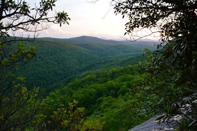
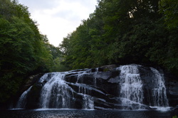
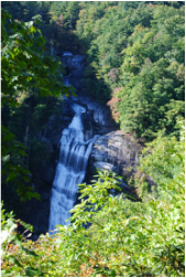
 Panthertown Valley is a mecca for outdoor recreation, with over a dozen waterfalls and many mountains that provide spectacular views. Some locations, such as Schoolhouse Falls and Little Green Mountain, are very popular. Other locations, such as Riding Ford Falls and Panthertail Mountain, are seldom visited or even heard of. On this hike, you will get to see as many as five waterfalls, with several others just a short ways off. Also, you'll visit two mountaintop vistas, with a third one nearby. Just make sure not to stray off too far on the unclear trail system on Panthertail Mountain, because you might have a long way back. This hike occurred on Saturday, May 28th, 2016. My plan was to begin this hike at Cold Mountain Gap, where I would take the Mac's Gap Trail to Greenland Creek. After hiking te short spur trail to Greenland Creek Falls, I would take the Greenland Creek Trail downstream along Greenland Creek, before turning onto an unofficial trail that led past Mac's Falls and Pothole Falls to Schoolhouse Falls. From Schoolhouse Falls, I would follow the Devil's Elbow Trail to its terminus at Shelton-Pisgah Trail, (with a short side trip to Riding Ford Falls along the way). Then, I would take the Shelton-Pisgah Trail across Shelton-Pisgah Mountain, before venturing onto a set of unofficial trails to Panthertail Mountain. From here, my plan was to return to Panthertown Valley by way of Little Green Creek, but things turned out otherwise, and I ended up following an unknown-to-me trail to Cold Mountain Gap Road.
0 Comments
The Unicoi Mountains straddle the Tennessee/North Carolina border in the Cherohala Skyway area. Bob Bald is one of the higher mountains in the range. At an elevation of 5294 feet, Bob Bald provides extensive views of the Citico Creek Wilderness and Joyce Kilmer-Slickrock Wilderness. There are several different ways to reach Bob Bald, but the easiest one is from Beech Gap on the Cherohala Skyway. You will first follow an abandoned forest road along the State Line Ridge, before taking off onto a singletrack trail that leads straight to Bob Bald. This hike occurred on Saturday, February 27, 2016. My plan was to hike closed Forest Road 217H from Beech Gap to the Bob Bald Connector Trail. From there, I would take the Bob Bald Connector Trail to the summit of Bob Bald. After visiting Bob Bald, I would return the same way.
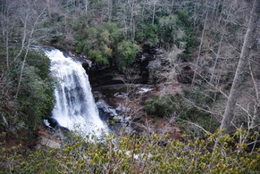
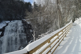 Gorges State Park is North Carolina's newest and westernmost state park, located in the area where Georgia, South Carolina, and North Carolina meet. The crown jewel of this still-developing park is the Rainbow Falls Trail, a normally easy hike that leads you to four spectacular waterfalls in the Horsepasture River gorge. On a day with 14-18 inches of fresh snow on the ground, however, the hike may not be so easy. This hike occurred on Saturday, January 23rd, 2016. My plan was to hike the Rainbow Falls Trail in the park out and back, visiting Stairstep Falls, Rainbow Falls, Turtleback Falls, and Drift Falls. I also planned to visit Raymond Fisher Pond and perhaps try some of the other short trails in the park. However, my plans were altered due to a heavy snowstorm that hit the region on the day before. All of western North Carolina got upwards of a half-foot of snow, with some areas (such as Gorges State Park) receiving as much as 18 inches. This caused Gorges State Park to be closed, and when I did this hike, I hiked the entrance road which added several miles more to my hike. Additionally, I was the first person to hike the Rainbow Falls Trail after snow, and with there being no previous footprints, it was a very slow and difficult hike. Thus, I was only able to hike the Rainbow Falls Trail to Rainbow Falls, Turtleback Falls, and Drift Falls.
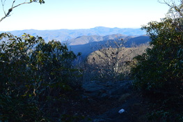 The Standing Indian Backcountry Area and the Southern Nantahala Wilderness comprise one unbroken tract of mountains and deep river valleys near the town of Franklin. The headquarters of Nantahala River, one of North Carolina's best-known rivers, are located here. Dozens of miles of hiking trails weave through the area. Two mountains are the key destinations in the region: Albert Mountain and Standing Indian Mountain. On this hike, you'll have the opportunity to use seldom-traveled trails in a loop or shuttle hike that visits the summit of Albert Mountain. This hike occurred on December 5th, 2015. My plan was to hike the Bearpen Gap Trail from the lower end near the Nantahala River to the upper end at the Appalachian Trail. From there, I would follow the Appalachian Trail up and over Albert Mountain to the Long Branch Trail. Using the Long Branch Trail, I would return to FS 67 and the Nantahala River area. I would finish by walking FS 67 back to the Bearpen Trail.
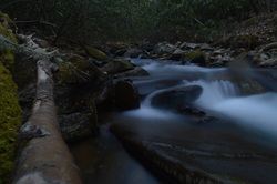
Deep in the Cheoah Ranger District of Nantahala National Forest flows a pristine wilderness waterway, Snowbird Creek. Snowbird Creek, encompassed by the large Snowbird Backcountry Area, is one of the more remote regions in western North Carolina, where trails can be overgrown streamside paths and where the junctions often go unsigned. Snowbird Creek and its tributaries sport numerous waterfalls, even some large ones - on this hike you'll get to see as many as four sizable waterfalls. It's no walk in the park to get as far as Upper Falls though - be prepared to traverse faint, steep paths on Burntrock Ridge and along Snowbird Creek. This hike occurred on Saturday, August 15th, 2015. My plan was to hike the Snowbird Creek Trail to the Sassafras Creek Trail, and then take Sassafras Creek Trail upstream along Sassafras Creek past Sassafras Creek Trail. Next, I would take the Burntrock Ridge Trail over Burntrock Ridge, ending up again on the Snowbird Creek Trail. I would take the Snowbird Creek Trail upstream to Upper Falls and then downstream to Middle Falls, Big Falls, and back to the trailhead.
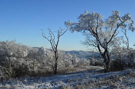
Southern Nantahala Wilderness is one of only two wilderness areas in Nantahala National Forest. However, it covers some very rugged and beautiful terrain across extreme southern North Carolina and a small section of north Georgia. The Tallulah River is one of the main rivers that eventually forms the Savannah River. Its headwaters are here. On this hike, you'll have a chance to see several of the headwater streams, at least two waterfalls, and an outstanding view. One thing though - be prepared for everything except an easy hike. This hike occurred on Saturday, March 7th, 2015. My plan was to hike the Deep Gap Branch Trail from the Dreamcatcher Cove Trailhead to its end on the Appalachian Trail at Deep Gap. From there, I would follow the Appalachian Trail to check out the vista on Standing Indian Mountain, this time in it's winter state, and then continue to Beech Gap. From Beech Gap, I would take an overgrown connector trail to Beech Creek Trail, and then continue down Beech Creek Trail to its end near the North Carolina/Georgia state line. I would finish the hike with a little roadwalk.
 The Chunky Gal Trail is a 21-mile long hiking trail that connects the Nantahala Mountains with the Tusquitee Mountains. Despite its unfortunate name, it has many great vistas and is a good trail. This is the first time I visited it, but I was pretty happy with it - and I will return. The trail visits key peaks of the area such as Tusquitee Bald and Boetler Peak, as well as Muskrat Creek Shelter on the Appalachian Trail, which is where it ends. This hike occurred on February 14th, 2015. Originally, my plan was to hike the Chunky Gal Trail westward from Tusquitee Gap all the way to Tusquitee Bald, but it turned out to be a much longer hike than information had suggested, so I decided to turn around at some cascades on Tuni Creek.
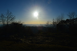
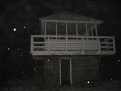 The Cowee Mountains is the highest mountain range in the Highlands-Cashiers area, with many mountains approaching 5000 feet. This hike leads to the highest point in the Cowee Mountains as well as the highest point in the entire Highlands-Cashiers area, Yellow Mountain. Yellow Mountain rises to 5127 feet, and has a historic, renovated fire lookout. You'll also pass over several other mountains with great winter views and some viewpoints as well. Chances are you will be tired by the time you make it back to the trailhead at Cole Gap, and although the fact that the route back is almost as hard as the way in is pretty major, the rewards will sill be worth it, especially on a clear day. This hike occurred on Thursday, November 27th, 2014. My plan was to hike the Yellow Mountain Trail from Cole Gap to Yellow Mountain, and then return the same way.
 I have hiked a bit on the Foothills Trail, but in general I have underestimated it. This primer on the Foothills Trail in extreme upstate South Carolina is about as good as it can get while hiking - in fact, this is one of my favorite hikes not only this year, but in the past few years. The Whitewater River starts in the mountains near Cashiers, and grows on its way to Lake Jocassee. There are six waterfalls on the Whitewater River, but two waterfalls are the biggest ones, and more importantly, will take your breath. First, Upper Whitewater Falls is a gigantic double-tiered waterfall, claimed to be the highest waterfall east of the Mississippi River. Following this, the Whitewater River plunges with whitewater through the Whitewater River Gorge, exiting the gorge with another dramatic drop at Lower Whitewater Falls, into Lake Jocassee. This hike occurred on Saturday, October 11th, 2014. My plan was to take the Bad Creek Access Trail to the Foothills Trail, and first take the Foothills Trail east to the Lower Whitewater Falls Trail, and follow it to the Lower Whitewater Falls Overlook. Following this, I would backtrack to the Bad Creek Access Trail, and take the Foothills Trail northwest to Upper Whitewater Falls. After this, I would return the same way to the trailhead.
 The Tusquitee Mountains of Southwest North Carolina are a beautiful mountain sub-range located near Hayesville. The highest mountain, Tusquitee Bald, tops out higher than 5000 feet. In a deep valley shaded by the mountains' crests flows Fires Creek. This clear, mountain stream houses a population of trout, rarely found in some of the mountains. The Fires Creek Rim Trail is the main trail that goes around the Tusquitee Mountains. However, there are also access trails, and the Chunky Gal Trail, which comes from the southeast. This hike occurred on October 4th, 2014. My original plan was to hike to Tusquitee Bald, but some roads were closed (possibly for hunting season), so I had to change my plan to starting at the Bristol Horse Camp, and doing the Bristol Trail to Fires Creek Rim Trail. Then, I would take the Fires Creek Rim Trail to the right (south-southwest) and follow it to Fires Creek Picnic Area. I wanted to return by the Cover Trail, but after quickly realizing that it has 18 fords, certainly not inviting in 40-degree weather, I bailed out and decided to return by the Fires Creek Road.
 Highlands and Cashiers are two small, wealthy towns in the mountains of Southwest North Carolina surrounded by mountains with great views and great hiking trails. The Panthertown Valley Recreation Area is one of the best hiking destinations in the area, with several mountains with great views, and at least a dozen accessible waterfalls. Panthertown Valley, nicknamed "The Yosemite of the East". Mountains like Little Green Mountain alone are worth doing this hike - traversing it's open rocky faces with incredible views is quite a feeling. This hike occurred on Saturday, September 13th, 2014. My plan was as follows (and it's a long one): From the Packs Gap Trailhead, take the Blackrock Spur Trail to Blackrock Trail. From there, I'd follow the Blackrock Trail to Overlook Trail. I would take the Overlook Trail to Blackrock Mountain Overlook and to the Powerline Trail. I would turn right on the Powerline Trail and go all the way to Panthertown Valley Trail. Along the way, I would do the short out-and-back to Wardens Falls. Then, I would turn left on Panthertown Valley Trail, followed by turning right onto Little Green Trail. After visiting Schoolhouse Falls, I would summit Little Green Mountain and on the other side of the mountain, turn left on Mac's Gap Trail. Then, I would turn right onto Big Green Trail and follow it to Great Wall Trail. I would turn left onto the Great Wall Trail and follow it to Granny Burrel Falls Trail. After doing the short out-and-back to Granny Burrell Falls, I would continue on the Great Wall Trail to Deep Gap Trail. I would turn left onto Deep Gap Trail, and immediately right onto Wilderness Falls Trail. Finally, I would finish by turning left onto the Panthertown Valley Trail and ascend to Packs Gap.
 The Fishawk Mountains west of Highlands are a small ridgeline and part of the Bartram Trail's route. In this area, the mountains house massive rock faces and fantastic panoramas of the Little Tennessee River Valley and Nantahala Mountains. This is easily one of the best hikes in the Highlands area. This hike occurred on Saturday, August 16th, 2014. My plan was to start my hike at the Jones Gap Trailhead and hike on the Bartram Trail to Wolf Rock. I would return the same way. Also, I would check out Jones Knob and Whiterock Mountain along the way. I would skip the Fishawk Mountain spur, though.
Appalachian Trail: Nantahala Outdoor Center (NOC) to Wesser Bald, Bryson City, North Carolina7/14/2014 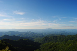
The Nantahala River is a premiere location for whitewater rafting and water slalom. The Nantahala Outdoor Center is situated right along the banks of the Nantahala's rushing waters, and on a good weekend, you can expect at least a hundred people here. Meanwhile, there's something for us hikers too. The Appalachian Trail passes through the NOC, crossing the busy US 74 and the Nantahala River. The Appalachian Trail offers a couple destinations in this area, including Cheoah Bald and Wesser Bald. While both are not easy to reach, both have ultimate rewarding views. This hike occurred on Friday, July 4th, 2014. My plan was to follow the Appalachian Trail from the NOC southward to the Jump-Up, and then even further to Wesser Bald and its fire tower. I would come back the same way.
Southern Nantahala Wilderness: Standing Indian Mountain via Lower Ridge Trail, Franklin, NC5/29/2014 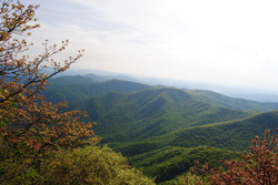
Ahh, there's so many areas that I still haven't explored, including the Southern Nantahala Wilderness, which has escaped my eye up to this hike. The Standing Indian Backcountry Area, along with the Southern Nantahala Wilderness, have both the highest mountain south of the Smokies and the headwaters of the famed Nantahala River. The greenery was superb, when I went here, with few rocks even at the summit. Although the better known Albert Mountain has a fire tower and beautiful views, I decided to tackle the higher and less-visited Standing Indian Mountain, which rivals Albert Mountain in terms of views. There's many ways to access Standing Indian Mountain, although I chose the least-used one. Little did I know how hard it would get. This hike occurred on Saturday, May 25th, 2014. My plan was to park at Standing Indian Campground, and follow the Lower Ridge Trail (#28) all the way to the summit of Standing Indian Mountain and its two overlooks. I would return the same way.
 The mountains of Southwestern NC are one of the most beautiful areas outside of the Smokies. In fact, a lot of these mountains have huge cliff faces, one of the biggest in the entire Eastern US. One of the more well-know mountains is Scaly Mountain, and the nearby Cullasja River Gorge, has an incredibly scenic road, and several beautiful waterfalls, including Dry Falls. I did this hike on Saturday, March 1st, 2014. My plans were to start at the Osage Overlook Trailhead for the Bartram Trail on NC Route 106, and take the Bartram Trail northward to the summit of Scaly Mountain, but my plans did not quite materialize.
|
About MeMark Oleg Ozboyd Dear readers: I have invested a tremendous amount of time and effort in this website and the Georgia Waterfalls Database the past five years. All of the work that has gone in keeping these websites updated with my latest trip reports has almost been like a full-time job. This has not allowed me to pick up a paid job to save up money for college, and therefore, I I've had to take out loans. If you find the information on this website interesting, helpful, or time-saving, you can say "thanks" and help me out by clicking the button above and making a contribution. I will be very grateful for any amount of support you give, as all of it will apply toward my college tuition. Thank you!

Coming in 2022-2023?
Other Hiking WebsitesMiles HikedYear 1: 540.0 Miles
Year 2: 552.3 Miles Year 3: 518.4 Miles Year 4: 482.4 Miles Year 5: 259.9 Miles Archives
March 2021
Categories
All
|
 RSS Feed